Boysen Dam

Last updated
Boysen Dam
Boysen Dam in 2012.jpg
Boysen Dam in 2012
USA Wyoming location map.svg
Red pog.svg
Location of Boysen Dam in the state of Wyoming.
CountryUnited States
Location Fremont County, Wyoming
Coordinates 43°25′02″N108°10′39″W / 43.41722°N 108.17750°W / 43.41722; -108.17750 Coordinates: 43°25′02″N108°10′39″W / 43.41722°N 108.17750°W / 43.41722; -108.17750
StatusIn use
Construction began1947
Opening date1952
Construction cost$18.5 million
Owner(s) U.S. Bureau of Reclamation
Dam and spillways
Type of dam Rockfill
Impounds Wind River
Height220 ft (67 m)
Length1,143 ft (348 m)
Elevation at crest4,758 ft (1,450 m)
Width (crest)30 ft (9.1 m)
Width (base)919 ft (280 m)
Dam volume1,527,386 cu yd (1,167,770 m3)
Spillways 2
Spillway typeConcrete chute and river outlets
Spillway capacity26,300 cu ft/s (740 m3/s)
Reservoir
Creates Boysen Reservoir
Total capacity952,400 acre⋅ft (1,174,800 dam3)
Active capacity802,000 acre⋅ft (989,000 dam3)
Inactive capacity150,400 acre⋅ft (185,500 dam3)
Catchment area 7,700 sq mi (20,000 km2)
Surface area19,560 acres (7,920 ha)
Maximum water depth117 ft (36 m)
Normal elevation4,732 ft (1,442 m) (max)
Power Station
Turbines 2
Installed capacity 15 MW
Annual generation 37,856,600 KWh

The Boysen Dam is a rockfill dam on the Wind River in the U.S. state of Wyoming. The dam lies at the head of Wind River Canyon through the Owl Creek Mountains in western Wyoming and creates Boysen Reservoir. It is owned by the U.S. Bureau of Reclamation and furnishes irrigation water supply to the Bighorn Basin as well as providing flood control and hydroelectric power.

Contents

History

The first dam to be built at the Wind River Canyon site was actually in 1908, when Asmus Boysen supervised the construction of a small concrete run-of-the-river structure that generated 710 kilowatts of electricity. This early dam, located just downriver of the present Boysen Dam, silted up by 1925 and was removed in 1948. [1] As early as 1904, the Bureau of Reclamation also made investigative forays into the area for the construction of a dam, although a final report was not completed until 1942. Initially, by a suggestion of the U.S. Army Corps of Engineers, the Boysen Dam would be built right over the site of the old dam, but the location was changed to about one and a half miles (2.4 km) upstream in order to reduce cost. [2]

Construction

Hydroelectric turbine installation at Boysen Dam 1947-1951 Boysen Dam Construction on the Boysen Project - Pick-Sloan Missouri Basin Program, 1947-1952 -throwbackthursday.jpg
Hydroelectric turbine installation at Boysen Dam 1947-1951

Preliminary work for construction of Boysen Dam was begun on September 9, 1946 and included the installation of government buildings, an employee camp, warehouses, electrical transmission lines and the relocation of U.S. Highway 20 and the Chicago, Burlington and Quincy Railway to bypass the construction site. The contract for the dam itself and the rerouting of the rail line was awarded to the Morrison-Knudsen Company for $13.9 million. Most of the preparatory work including foundation excavations and the various camp facilities were completed by the end of autumn 1947, and official groundbreaking was on September 19 of that year. [3]

In February 1948, excavation of the river diversion tunnel began and work continued on the relocation of the railway, which would run under the dam and portions of the future reservoir through a tunnel 7,131 feet (2,174 m) long. By March 1949, the diversion tunnel was successfully complete and the rail realignment mostly finished despite several minor setbacks including a rockslide and a fire that destroyed the concrete mixing plant. On December 23, 1949 a cofferdam across the Wind was finished and the river began flowing through the diversion tunnel, allowing work to proceed on the main section of the dam. As the embankment rose, the train tunnel was completed and opened on September 5, 1950 and work begun on the dam's power plant. Contracts for clearing the reservoir area were awarded beginning in September and came out to about $637,000. [3]

Construction on the powerhouse continued through 1951 and equipment began coming into the dam site beginning in July of that year. The total cost of the generators and other apparatus came to $604,501. The embankment of the dam was completed a month later, and on October 11, 1951, the diversion tunnel was sealed and Boysen Reservoir began to rise. The powerhouse was finished in December 1951 and the entire dam was completed on February 16, 1952 at a cost of $18,576,405. [3] The dam was declared operational on December 11, 1952.

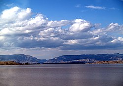
Structure and operations

View of Boysen Reservoir Boysen Reservoir.jpg
View of Boysen Reservoir

Boysen Dam is an earth and rock fill structure 220 feet (67 m) high from the foundations and 1,143 ft (348 m) long. The hydraulic head is only about 117 ft (36 m) because of the great depth to bedrock from the riverbed, thus necessitating a large amount of excavation for the dam foundations. The reservoir has a storage capacity of 952,400 acre-feet (1.1748 km3), of which 520,679 acre⋅ft (0.642248 km3) is reserved for annual flood storage and 144,229 acre⋅ft (0.177904 km3) for agricultural and municipal uses. The dam provides electricity for regions of Wyoming ranging from Alcova to Thermopolis. [2] [4]

The dam also serves an important purpose of flood control, and has prevented about $75 million of damages from its completion to 1998. Its spillway is a concrete lined, over the crest structure controlled by two radial gates with a capacity of 25,000 cubic feet per second (710 m3/s). [5]

Energy Generation Data

See also

Related Research Articles

<span class="mw-page-title-main">Glen Canyon Dam</span> Dam in Arizona

Glen Canyon Dam is a concrete arch-gravity dam in the southwestern United States, located on the Colorado River in northern Arizona, near the town of Page. The 710-foot-high (220 m) dam was built by the Bureau of Reclamation (USBR) from 1956 to 1966 and forms Lake Powell, one of the largest man-made reservoirs in the U.S. with a capacity of more than 25 million acre-feet (31 km3). The dam is named for Glen Canyon, a series of deep sandstone gorges now flooded by the reservoir; Lake Powell is named for John Wesley Powell, who in 1869 led the first expedition to traverse the Colorado River's Grand Canyon by boat.

<span class="mw-page-title-main">Trinity Dam</span> Dam in Trinity County, California

Trinity Dam is an earthfill dam on the Trinity River located about 7 miles (11 km) northeast of Weaverville, California in the United States. The dam was completed in the early 1960s as part of the federal Central Valley Project to provide irrigation water to the arid San Joaquin Valley.

<span class="mw-page-title-main">Pathfinder Dam</span> Dam in Wyoming, USA

Pathfinder Dam is a masonry dam, located on the North Platte River, approximately 47 miles (76 km) southwest of Casper, Wyoming. It was originally constructed from 1905 to 1909 as part of the North Platte Project and has been modified several times since then. It is included on the National Register of Historic Places. Construction of the dam created Pathfinder Reservoir which provides water storage for 226,000 acres (910 km2) of irrigation in Wyoming and Nebraska. The dam is named for General John Charles Fremont, who had explored the area in 1842 and was nicknamed the "Pathfinder of the West."

<span class="mw-page-title-main">Flaming Gorge Dam</span> Dam on the Green River in Utah, United States

Flaming Gorge Dam is a concrete thin-arch dam on the Green River, a major tributary of the Colorado River, in northern Utah in the United States. Flaming Gorge Dam forms the Flaming Gorge Reservoir, which extends 91 miles (146 km) into southern Wyoming, submerging four distinct gorges of the Green River. The dam is a major component of the Colorado River Storage Project, which stores and distributes upper Colorado River Basin water.

<span class="mw-page-title-main">Blue Mesa Dam</span> Dam in Colorado, United States

Blue Mesa Dam is a 390-foot-tall (120 m) zoned earthfill dam on the Gunnison River in Colorado. It creates Blue Mesa Reservoir, and is within Curecanti National Recreation Area just before the river enters the Black Canyon of the Gunnison. The dam is upstream of the Morrow Point Dam. Blue Mesa Dam and reservoir are part of the Bureau of Reclamation's Wayne N. Aspinall Unit of the Colorado River Storage Project, which retains the waters of the Colorado River and its tributaries for agricultural and municipal use in the American Southwest. Although the dam does produce hydroelectric power, its primary purpose is water storage. State Highway 92 passes over the top of the dam. Blue Mesa Dam houses two turbine generators and produces an average of 264,329,000 kilowatt-hours each year.

<span class="mw-page-title-main">Morrow Point Dam</span> Dam on the Gunnison River in Colorado

Morrow Point Dam is a 468-foot-tall (143 m) concrete double-arch dam on the Gunnison River located in Colorado, the first dam of its type built by the U.S. Bureau of Reclamation. Located in the upper Black Canyon of the Gunnison, it creates Morrow Point Reservoir, and is within the National Park Service-operated Curecanti National Recreation Area. The dam is between the Blue Mesa Dam (upstream) and the Crystal Dam (downstream). Morrow Point Dam and reservoir are part of the Bureau of Reclamation's Wayne N. Aspinall Unit of the Colorado River Storage Project, which retains the waters of the Colorado River and its tributaries for agricultural and municipal use in the American Southwest. The dam's primary purpose is hydroelectric power generation.

<span class="mw-page-title-main">Navajo Dam</span> Dam in San Juan and Rio Arriba Counties, New Mexico

Navajo Dam is a dam on the San Juan River, a tributary of the Colorado River, in northwestern New Mexico in the United States. The 402-foot (123 m) high earthen dam is situated in the foothills of the San Juan Mountains about 44 miles (71 km) upstream and east of Farmington, New Mexico. It was built by the U.S. Bureau of Reclamation (Reclamation) in the 1960s to provide flood control, irrigation, domestic and industrial water supply, and storage for droughts. A small hydroelectric power plant was added in the 1980s.

<span class="mw-page-title-main">Wind River Canyon</span>

Wind River Canyon is a scenic Wyoming canyon on the Wind River. It is located between the towns of Shoshoni and Thermopolis and is a popular stop for visitors to Yellowstone National Park. It is accessible by U.S. Highway 20 and Wyoming Highway 789. It was designated as a Wyoming Scenic Byway in 2005.

<span class="mw-page-title-main">Jackson Lake Dam</span> Dam in Wyoming, in Grand Teton National Park

Jackson Lake Dam is a concrete and earth-fill dam in the western United States, at the outlet of Jackson Lake in northwestern Wyoming. The lake and dam are situated within Grand Teton National Park in Teton County. The Snake River emerges from the dam and flows about eight hundred miles (1,300 km) through Wyoming, Idaho, Oregon, and Washington to its mouth on the Columbia River in eastern Washington.

<span class="mw-page-title-main">Yellowtail Dam</span> Dam in Big Horn County, Montana

Yellowtail Dam is a dam across the Bighorn River in south central Montana in the United States. The mid-1960s era concrete arch dam serves to regulate the flow of the Bighorn for irrigation purposes and to generate hydroelectric power. The dam and its reservoir, Bighorn Lake, are owned by the U.S. Bureau of Reclamation.

<span class="mw-page-title-main">Auburn Dam</span> Dam in Near Auburn, California

Auburn Dam was a proposed concrete arch dam on the North Fork of the American River east of the town of Auburn, California, in the United States, on the border of Placer and El Dorado Counties. Slated to be completed in the 1970s by the U.S. Bureau of Reclamation, it would have been the tallest concrete dam in California and one of the tallest in the United States, at a height of 680 feet (210 m) and storing 2,300,000 acre-feet (2.8 km3) of water. Straddling a gorge downstream of the confluence of the North and Middle Forks of the American River and upstream of Folsom Lake, it would have regulated water flow and provided flood control in the American River basin as part of Reclamation's immense Central Valley Project.

<span class="mw-page-title-main">Buffalo Bill Dam</span> Dam in Wyoming

Buffalo Bill Dam is a concrete arch-gravity dam on the Shoshone River in the U.S. state of Wyoming. It is named after the famous Wild West figure William "Buffalo Bill" Cody, who founded the nearby town of Cody and owned much of the land now covered by the reservoir formed by its construction. The dam is part of the Shoshone Project, successor to several visionary schemes promoted by Cody to irrigate the Bighorn Basin and turn it from a semi-arid sagebrush-covered plain to productive agricultural land. Known at the time of its construction as Shoshone Dam, it was renamed in 1946 to honor Cody.

<span class="mw-page-title-main">Fontenelle Dam</span> Dam on the Green River in Wyoming

Fontenelle Dam was built between 1961 and 1964 on the Green River in southwestern Wyoming. The 139-foot (42 m) high zoned earthfill dam impounds the 345,360-acre-foot (0.42600 km3) Fontenelle Reservoir. The dam and reservoir are the central features of the Seedskadee Project of the U.S. Bureau of Reclamation, which manages the Fontenelle impoundment primarily as a storage reservoir for the Colorado River Storage Project. The dam suffered a significant failure in 1965, when the dam's right abutment developed a leak. Emergency releases from the dam flooded downstream properties, but repairs to the dam were successful. However, in 1983 the dam was rated "poor" under Safety Evaluation of Existing Dams (SEED) criteria, due to continuing seepage, leading to an emergency drawdown. A concrete diaphragm wall was built through the core of the dam to stop leakage.

<span class="mw-page-title-main">Risks to the Glen Canyon Dam</span> Aspect of dam construction

Glen Canyon Dam, a concrete arch dam on the Colorado River in the American state of Arizona, is viewed as carrying a large amount of risk, most notably due to siltation. The Colorado and San Juan rivers deposit large volumes of silt into Lake Powell, slowly decreasing its capacity. The sediment will eventually build up against the dam and could affect its safe operation and lead to its failure.

<span class="mw-page-title-main">Seminoe Dam</span> Dam in Carbon County, Wyoming

Seminoe Dam is a concrete thick-arch dam on the North Platte River in the U.S. state of Wyoming. The dam stores water for irrigation and hydroelectricity generation, and is owned and operated by the U.S. Bureau of Reclamation. It is the uppermost dam on the North Platte River and is located directly upstream from the Kortes Dam. It lies in a narrow, isolated canyon formed by the North Platte cutting through the Seminoe Mountains about 40 miles (64 km) northeast of Rawlins. The 295-foot (90 m) dam forms Seminoe Reservoir, which covers more than 20,000 acres (8,100 ha) when full. Seminoe State Park is adjacent to the reservoir. The small village of Seminoe Dam abuts the dam and reservoir, and provides residence for the dam attendants and park services personnel.

<span class="mw-page-title-main">Pactola Dam</span> Dam in Pennington County, South Dakota

Pactola Dam is an embankment dam on Rapid Creek in Pennington County, South Dakota, about 10 miles (16 km) west of Rapid City. The dam was completed in 1956 by the U.S. Bureau of Reclamation to provide flood control, water supply and recreation. Along with the nearby Deerfield Dam, it is part of the Rapid Valley Unit of the Pick-Sloan Missouri Basin Program. U.S. Route 385 runs along the crest of the dam. The dam forms Pactola Lake, which at over 1,200 acres (490 ha) is the largest and deepest body of water in the Black Hills.

<span class="mw-page-title-main">San Juan–Chama Project</span> Water management project in New Mexico and Colorado

The San Juan–Chama Project is a U.S. Bureau of Reclamation interbasin water transfer project located in the states of New Mexico and Colorado in the United States. The project consists of a series of tunnels and diversions that take water from the drainage basin of the San Juan River – a tributary of the Colorado River – to supplement water resources in the Rio Grande watershed. The project furnishes water for irrigation and municipal water supply to cities along the Rio Grande including Albuquerque and Santa Fe.

<span class="mw-page-title-main">Gibson Dam</span> Dam in Lewis and Clark/Teton Counties, Montana

Gibson Dam is a concrete arch dam on the Sun River, a tributary of the Missouri River, about 60 miles (97 km) west of Great Falls, Montana in the United States. Located on the eastern edge of the Rocky Mountains, the dam was built by the U.S. Bureau of Reclamation (USBR) between 1926 and 1929 as part of the Sun River Project to develop about 93,000 acres (38,000 ha) of irrigated land in the Sun River Valley.

<span class="mw-page-title-main">Angostura Dam (U.S.)</span> Dam in Fall River County, South Dakota

Angostura Dam is an embankment dam across the Cheyenne River in Fall River County in southwestern South Dakota in the United States, about 75 miles (121 km) south of Rapid City. The dam consists of an earth-fill embankment with a concrete spillway section, 193 feet (59 m) high and 2,030 feet (620 m) long; it withholds the 195,121-acre-foot (0.240678 km3) Angostura Reservoir. The dam was conceived as early as 1913, but it was not until the 1930s when a regional drought caused crop failures that the project received widespread support from farmers. Built from 1946 to 1949, the dam is part of the Angostura Division of the Pick-Sloan Missouri Basin Program, and is operated by the U.S. Bureau of Reclamation.

<span class="mw-page-title-main">Middle Rio Grande Project</span>

The Middle Rio Grande Project manages water in the Albuquerque Basin of New Mexico, United States. It includes major upgrades and extensions to the irrigation facilities built by the Middle Rio Grande Conservancy District and modifications to the channel of the Rio Grande to control sedimentation and flooding. The bulk of the work was done by the United States Bureau of Reclamation and the United States Army Corps of Engineers in the 1950s, but construction continued into the 1970s and maintenance is ongoing. The project is complementary to the San Juan-Chama Project, which transfers water from the San Juan River in the Colorado River Basin to the Rio Grande. Although distribution of water from the two projects is handled through separate allotments and contracts, there is some sharing of facilities including the river itself. The ecological impact on the river and the riparian zone was the subject of extended litigation after a group of environmentalists filed Rio Grande Silvery Minnow v. Bureau of Reclamation in 1999.

References

  1. "History of Boysen Reservoir". Wyoming Parks and Cultural Resources. Angler Guide. Archived from the original on 2011-07-19. Retrieved 2011-04-05.
  2. 1 2 "Boysen Division". Pick Sloan Missouri Basin Program. U.S. Bureau of Reclamation. 2010-08-03. Retrieved 2011-04-05.
  3. 1 2 3 Simonds, Joe (1999). "The Boysen Unit - Boysen Division, Pick Sloan Missouri Basin Program" (PDF). Bureau of Reclamation History Program. U.S. Bureau of Reclamation. Retrieved 2011-04-05.
  4. "Boysen Dam Dimensions". Boysen Division. U.S. Bureau of Reclamation. 2008-11-05. Retrieved 2011-04-05.
  5. "Boysen Dam Hydraulics & Hydrology". Boysen Division. U.S. Bureau of Reclamation. 2008-11-05. Retrieved 2011-04-05.
  6. "Hydromet: ARC050, Daily Data for One Year". Bureau of Reclamation. Retrieved 11 August 2021.
  7. "Hydromet: ARC050, Daily Data for One Year". Bureau of Reclamation. Retrieved 11 August 2021.