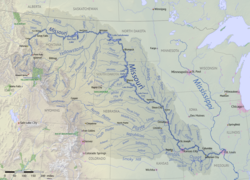
This is a list of dams in the watershed of the Missouri River , a tributary of the Mississippi River, in the United States. There are an estimated 17,200 dams and reservoirs in the basin, most of which are small, local irrigation structures. Reservoirs in the watershed total a capacity of approximately 141,000,000 acre feet (174 km3). [1]
Name | State | Reservoir | Height | Storage capacity | Capacity (MW) | ||
---|---|---|---|---|---|---|---|
ft | m | acre.ft | km3 | ||||
Toston Dam | MT | 56 | 17 | 3,000 | 0.004 | 10 | |
Canyon Ferry Dam | MT | Canyon Ferry Lake | 225 | 69 | 1,973,000 | 2.434 | 50 |
Hauser Dam | MT | Hauser Lake | 80 | 24 | 98,000 | 0.121 | 19 |
Holter Dam | MT | Holter Lake | 124 | 38 | 243,000 | 0.300 | 48 |
Black Eagle Dam | MT | Long Pool | 13 | 4 | 2,000 | 0.002 | 21 |
Rainbow Dam | MT | 29 | 9 | 1,000 | 0.001 | 36 | |
Cochrane Dam | MT | 59 | 18 | 3,000 | 0.004 | 64 | |
Ryan Dam | MT | 61 | 19 | 5,000 | 0.006 | 60 | |
Morony Dam | MT | 59 | 18 | 3,000 | 0.004 | 48 | |
Fort Peck Dam | MT | Fort Peck Lake | 250 | 76 | 18,690,000 | 23.053 | 185 |
Garrison Dam | ND | Lake Sakakawea | 210 | 64 | 23,800,000 | 29.356 | 515 |
Oahe Dam | SD | Lake Oahe | 245 | 75 | 23,500,000 | 28.986 | 786 |
Big Bend Dam | SD | Lake Sharpe | 95 | 29 | 1,910,000 | 2.356 | 493 |
Fort Randall Dam | SD | Lake Francis Case | 165 | 50 | 5,700,000 | 7.031 | 320 |
Gavins Point Dam | NE SD | Lewis and Clark Lake | 74 | 23 | 492,000 | 0.607 | 132 |
All tributary dams with a storage capacity greater than 250,000 acre feet (0.31 km3) are listed in the table below.
The Missouri River is the longest river in North America. Rising in the Rocky Mountains of western Montana, the Missouri flows east and south for 2,341 miles (3,767 km) before entering the Mississippi River north of St. Louis, Missouri. The river drains a sparsely populated, semi-arid watershed of more than 500,000 square miles (1,300,000 km2), which includes parts of ten U.S. states and two Canadian provinces. Although nominally considered a tributary of the Mississippi, the Missouri River above the confluence is much longer and carries a comparable volume of water. When combined with the lower Mississippi River, it forms the world's fourth longest river system.
The Tuolumne River flows for 149 miles (240 km) through Central California, from the high Sierra Nevada to join the San Joaquin River in the Central Valley. Originating at over 8,000 feet (2,400 m) above sea level in Yosemite National Park, the Tuolumne drains a rugged watershed of 1,958 square miles (5,070 km2), carving a series of canyons through the western slope of the Sierra. While the upper Tuolumne is a fast-flowing mountain stream, the lower river crosses a broad, fertile and extensively cultivated alluvial plain. Like most other central California rivers, the Tuolumne is dammed multiple times for irrigation and the generation of hydroelectricity.
Fort Peck Lake, or Lake Fort Peck, is a major reservoir in Montana, formed by the Fort Peck Dam on the Missouri River. The lake lies in the eastern prairie region of Montana approximately 140 miles (230 km) east of Great Falls and 120 miles (190 km) north of Billings, reaching into portions of six counties.
Clear Lake Reservoir is a reservoir in the Klamath Basin and the Modoc National Forest, in northwestern Modoc County, California.
The Bog Brook Reservoir is a 379-acre (153 ha) reservoir in the Croton Watershed in southern New York State, part of the New York City water supply system. It is located in the town of Southeast in Putnam County, approximately 38 miles (61 km) north of New York City. It was formed by the damming of Bog Brook, a small tributary of the East Branch of the Croton River. The reservoir was put into service in 1892, making it one of the older in the system.
The Croton Falls Reservoir is a reservoir in the New York City water supply system in the Putnam County, New York townships of Carmel, and Southeast, roughly 50 miles (80 km) north of New York City. Part of the system's Croton Watershed, it was formed by impounding the West Branch and Middle Branch of the Croton River, tributaries of the Croton River, which flows into the Hudson River.
The Ware River is a 35.4-mile-long (57.0 km) river in central Massachusetts. It has two forks, the longer of which begins in Hubbardston, Massachusetts. The Ware River flows southwest through the middle of the state, joins the Quaboag River at Three Rivers, Massachusetts, to form the Chicopee River on its way to the Connecticut River.
The Millers River is a 52.1-mile-long (83.8 km) river in northern Massachusetts, originating in Ashburnham and joining the Connecticut River just downstream from Millers Falls, Massachusetts. The river was formerly known as Paquag or Baquag, a Nipmuc word meaning "clear water". Sections of the river are used for whitewater kayaking, and a section upriver is popular with flatwater racers.
Yellowtail Dam is a dam across the Bighorn River in south central Montana in the United States. The mid-1960s era concrete arch dam serves to regulate the flow of the Bighorn for irrigation purposes and to generate hydroelectric power. The dam and its reservoir, Bighorn Lake, are owned by the U.S. Bureau of Reclamation.
The Sierra Madre Dam is a dam on Little Santa Anita Creek, at the mouth of Little Santa Anita Canyon, in Los Angeles County, California. It is in the San Gabriel Mountains, south of the Angeles National Forest, on the northern border of Sierra Madre.
The Colorado River Storage Project is a United States Bureau of Reclamation project designed to oversee the development of the upper Colorado River basin. The project provides hydroelectric power, flood control and water storage for participating states along the upper portion of the Colorado River and its major tributaries.
Spring Creek Debris Dam is an earthfill dam on Spring Creek, a tributary of the Sacramento River, in Shasta County in the U.S. state of California. Completed in 1963, the dam, maintained by the U.S. Bureau of Reclamation, serves primarily to collect severe acid mine drainage stemming from the Iron Mountain Mine. The dam forms the Spring Creek Reservoir, less than 1 mile (1.6 km) long. Spring Creek and South Fork Spring Creek flow into the reservoir from a 16-square-mile (41 km2) watershed. The dam is directly upstream from the city of Keswick, California and the Keswick Reservoir. The operation is part of the Trinity River Division of the Central Valley Project.
Stony Brook is a stream largely running through Lincoln and Weston, Massachusetts, then forming the Weston/Waltham boundary, and emptying into the Charles River across from the Waltham/Newton boundary. It has two tributaries, Cherry Brook and Hobbs Brook, and its watershed includes about half of Lincoln and Weston as well as parts of Lexington and Waltham. Since 1887, it has been the water supply for Cambridge.
Pactola Dam is an embankment dam on Rapid Creek in Pennington County, South Dakota, about 10 miles (16 km) west of Rapid City. The dam was completed in 1956 by the U.S. Bureau of Reclamation to provide flood control, water supply and recreation. Along with the nearby Deerfield Dam, it is part of the Rapid Valley Unit of the Pick-Sloan Missouri Basin Program. U.S. Route 385 runs along the crest of the dam. The dam forms Pactola Lake, which at over 1,200 acres (490 ha) is the largest and deepest body of water in the Black Hills.
The San Juan–Chama Project is a U.S. Bureau of Reclamation interbasin water transfer project located in the states of New Mexico and Colorado in the United States. The project consists of a series of tunnels and diversions that take water from the drainage basin of the San Juan River – a tributary of the Colorado River – to supplement water resources in the Rio Grande watershed. The project furnishes water for irrigation and municipal water supply to cities along the Rio Grande including Albuquerque and Santa Fe.
Lovewell Reservoir is a reservoir in Jewell County, Kansas, United States. Built and managed by the U.S. Bureau of Reclamation, it is used for flood control, irrigation, and recreation. Lovewell State Park is located on its north shore.
Angostura Dam is an embankment dam across the Cheyenne River in Fall River County in southwestern South Dakota in the United States, about 75 miles (121 km) south of Rapid City. The dam consists of an earth-fill embankment with a concrete spillway section, 193 feet (59 m) high and 2,030 feet (620 m) long; it withholds the 195,121-acre-foot (0.240678 km3) Angostura Reservoir. The dam was conceived as early as 1913, but it was not until the 1930s when a regional drought caused crop failures that the project received widespread support from farmers. Built from 1946 to 1949, the dam is part of the Angostura Division of the Pick-Sloan Missouri Basin Program, and is operated by the U.S. Bureau of Reclamation.
Shadehill Dam is a dam on the Grand River in Perkins County in northwestern South Dakota in the United States, about 10 miles (16 km) south of Lemmon. The dam and its impoundment, Shadehill Reservoir, serve mainly for flood and silt control, wildlife conservation and recreation. Located directly below the confluence of the North and South Forks of the Grand River, the dam is operated by the U.S. Bureau of Reclamation, and is part of the Shadehill Unit of the Pick-Sloan Missouri Basin Program.
The Kirk Lake is a reservoir in the hamlet of Mahopac in the town of Carmel in Putnam County, New York. It lies due west and sharply below considerably larger Lake Mahopac. It is one of three controlled lakes in the New York City water supply system's Croton Watershed.