The North Platte River is a major tributary of the Platte River and is approximately 716 miles (1,152 km) long, counting its many curves. In a straight line, it travels about 550 miles (890 km), along its course through the U.S. states of Colorado, Wyoming, and Nebraska.

San Luis Dam, also known as B.F. Sisk Dam, is a major earth-filled dam in Merced County, California, which forms San Luis Reservoir, the largest off-stream reservoir in the United States. The dam and reservoir are located in the Diablo Range to the east of Pacheco Pass and about 10 miles (16 km) west of Los Banos. San Luis Dam, a jointly-owned state and federal facility, stores more than 2 million acre feet (2.5 km3) of water for the California State Water Project and the federal Central Valley Project. Although the dam is located in the valley of San Luis Creek, the majority of its water comes from man-made aqueducts which are supplied from other rivers in Northern California.

The Colorado–Big Thompson Project is a federal water diversion project in Colorado designed to collect West Slope mountain water from the headwaters of the Colorado River and divert it to Colorado's Front Range and plains. In Colorado, approximately 80% of the state's precipitation falls on the West Slope, in the Rocky Mountains, while around 80% of the state's growing population lives along the eastern slope, between the cities of Fort Collins and Pueblo.

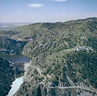
Pathfinder Dam is a masonry dam, located on the North Platte River, approximately 47 miles (76 km) southwest of Casper, Wyoming. It was constructed from 1905 to 1909 as part of the North Platte Project and has been modified several times since then. It is included on the National Register of Historic Places. Construction of the dam created Pathfinder Reservoir which provides water storage for 226,000 acres (910 km2) of irrigation in Wyoming and Nebraska. The dam is named for General John Charles Fremont, who had explored the area in 1842 and was nicknamed the "Pathfinder of the West."
Palisades Dam is an earth-fill dam in the western United States, on the upper Snake River in eastern Idaho. Located in Bonneville County near the Wyoming border, the dam was completed 67 years ago in 1957.

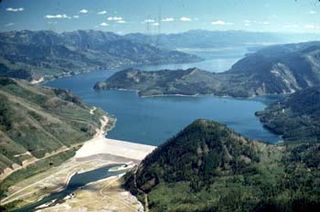
Flaming Gorge Dam is a concrete thin-arch dam on the Green River, a major tributary of the Colorado River, in northern Utah in the United States. Flaming Gorge Dam forms the Flaming Gorge Reservoir, which extends 91 miles (146 km) into southern Wyoming, submerging four distinct gorges of the Green River. The dam is a major component of the Colorado River Storage Project, which stores and distributes upper Colorado River Basin water.

The Shoshone Project is an irrigation project in the U.S. state of Wyoming. The project provides irrigation for approximately 107,000 acres (430 km2) of crops in the Big Horn Basin, fulfilling the vision of local resident and developer Buffalo Bill Cody, who hoped to make the semi-arid basin into agricultural land. Buffalo Bill Dam on the Shoshone River impounds water for the project in Buffalo Bill Reservoir. In addition to its role in irrigation, the project provides flood control on the Shoshone and generates power, using the 350-foot (110 m) height of Buffalo Bill Dam, once a world record, and the considerable fall of the river through Shoshone Canyon to generate hydroelectric power. Chief crops in the Big Horn Basin are sugar beets, alfalfa, barley, oats, corn and beans.
Lake McConaughy is a reservoir on the North Platte River. It is located 9 miles (14 km) north of Ogallala, Nebraska, United States, near U.S. Highway 26 and Nebraska Highway 61. The reservoir was named for Charles W. McConaughy, a grain merchant and mayor of Holdrege, Nebraska, one of the leading promoters of the project. Although he did not live to see the completion of the project, his leadership and perseverance eventually culminated in a public power and irrigation project that helped Nebraska become one of the nation's leading agricultural states.

The Colorado River Storage Project is a United States Bureau of Reclamation project designed to oversee the development of the upper basin of the Colorado River. The project provides hydroelectric power, flood control and water storage for participating states along the upper portion of the Colorado River and its major tributaries.

Glendo Reservoir is a reservoir located on the North Platte River in Platte County and Converse County in the U.S. State of Wyoming. The reservoir is formed by Glendo Dam. The earthfill dam is 2,096 feet (639 m) feet long and 190 feet (58 m) high and contains two hydroelectric turbines capable of generating 38 megawatts of power. The reservoir retains a maximum of 1,170,505 acre-feet (1.443797×10⁹ m3) of water used primarily for irrigation and flood control.

Guernsey Dam is an earthfill dam on the North Platte River in Platte County in the U.S. State of Wyoming. The dam creates Guernsey Reservoir, the last of the 5 major reservoirs on the North Platte River in Wyoming. The dam contains a hydroelectric plant capable of 6.4 megawatts of electricity. The total capacity of the reservoir is 71,040 acre-feet (87,630,000 m3) of water which is used mainly for irrigation. Morrison-Knudsen and Utah Construction Company constructed Guernsey Dam and the hydroelectric plant as part of the North Platte Project to provide irrigation to eastern Wyoming and western Nebraska. Guernsey helps control the river flow and stores water released from the project's primary storage upstream at Pathfinder Reservoir. About 8 miles (13 km) downstream of the dam the Whalen Diversion Dam diverts water into the Fort Laramie and Interstate Canals that service farms in Wyoming and Nebraska.

The Minidoka Project is a series of public works by the U.S. Bureau of Reclamation to control the flow of the Snake River in Wyoming and Idaho, supplying irrigation water to farmlands in Idaho. One of the oldest Bureau of Reclamation projects in the United States, the project involves a series of dams and canals intended to store, regulate and distribute the waters of the Snake, with electric power generation as a byproduct. The water irrigates more than a million acres (4,000 km²) of otherwise arid land, producing much of Idaho's potato crop. Other crops include alfalfa, fruit and sugar beets. The primary irrigation district lies between Ashton in eastern Idaho and Bliss in the southwestern corner of the state. Five main reservoirs collect water, distributing it through 1,600 miles (2,600 km) of canals and 4,000 miles (6,400 km) of lateral distribution ditches.

The Boysen Dam is a rockfill dam on the Wind River in the U.S. state of Wyoming. The dam lies at the head of Wind River Canyon through the Owl Creek Mountains in western Wyoming and creates Boysen Reservoir. It is owned by the U.S. Bureau of Reclamation and furnishes irrigation water supply to the Bighorn Basin as well as providing flood control and hydroelectric power.

Alcova Dam is a 265-foot (81 m) tall zoned earthfill dam in central Wyoming, built in 1935-38 on the North Platte River and operated by the U.S. Bureau of Reclamation for water storage and hydroelectric power generation. The dam was built as part of the Kendrick Project, formerly the Casper-Alcova Project, whose central features are Alcova and Seminoe dams.
The Seedskadee Project is a water resources development project of the U.S. Bureau of Reclamation. The project focuses on the upper Green River in western Wyoming, storing the river's waters in Fontenelle Reservoir. The project is associated with the Colorado River Storage Project, retaining the waters of the Green for use in the upper Colorado Basin. Water held behind Fontenelle Dam, built from 1961 to 1968, is used for hydroelectric power generation and industrial use. The reservoir supports recreational use.

Gibson Dam is a concrete arch dam on the Sun River, a tributary of the Missouri River, about 60 miles (97 km) west of Great Falls, Montana in the United States. Located on the eastern edge of the Rocky Mountains, the dam was built by the U.S. Bureau of Reclamation (USBR) between 1926 and 1929 as part of the Sun River Project to develop about 93,000 acres (38,000 ha) of irrigated land in the Sun River Valley.

Kortes Dam is a dam in Carbon County, Wyoming.