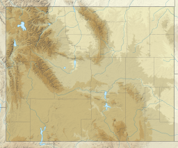
The Missouri River is the longest river in the United States. Rising in the Eastern Centennial Mountains of the Bitteroot Range of the Rocky Mountains of Southwestern Montana, the Missouri flows east and south for 2,341 miles (3,767 km) before entering the Mississippi River north of St. Louis, Missouri. The river drains a sparsely populated, semi-arid watershed of more than 500,000 square miles (1,300,000 km2), which includes parts of ten U.S. states and two Canadian provinces. Although a tributary of the Mississippi, the Missouri River is slightly longer and carries a comparable volume of water. When combined with the lower Mississippi River, it forms the world's fourth longest river system.

The Snake River is a major river of the greater Pacific Northwest region in the United States. At 1,078 miles (1,735 km) long, it is the largest tributary of the Columbia River, in turn, the largest North American river that empties into the Pacific Ocean. The Snake River rises in western Wyoming, then flows through the Snake River Plain of southern Idaho, the rugged Hells Canyon on the Oregon–Idaho border and the rolling Palouse Hills of Washington, emptying into the Columbia River at the Tri-Cities in the Columbia Basin of Eastern Washington.

The South Platte River is one of the two principal tributaries of the Platte River. Flowing through the U.S. states of Colorado and Nebraska, it is itself a major river of the American Midwest and the American Southwest/Mountain West. Its drainage basin includes much of the eastern flank of the Rocky Mountains in Colorado, much of the populated region known as the Colorado Front Range and Eastern Plains, and a portion of southeastern Wyoming in the vicinity of the city of Cheyenne. It joins the North Platte River in western Nebraska to form the Platte, which then flows across Nebraska to the Missouri. The river serves as the principal source of water for eastern Colorado. In its valley along the foothills in Colorado, it has permitted agriculture in an area of the Colorado Piedmont and Great Plains that is otherwise arid.

Shoshoni is a town in Fremont County, Wyoming, United States. The population was 471 at the 2020 census, down from 649 at the 2010 census. The town has gained notoriety as a speed trap due to numerous references citing its aggressive enforcement of traffic laws. According to available data, the town has a 32% ticket to resident rate, suggesting a disproportionate number of traffic tickets issued to drivers passing through the area. This has led to criticism and controversy surrounding the town's policing practices. The town is named for the Shoshone Indian tribe, most of whom live on the nearby Wind River Indian Reservation.

Thermopolis is the county seat and most populous town in Hot Springs County, Wyoming, United States. As of the 2020 U.S. Census, the town population was 2,725.
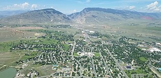
Cody is a city in Northwest Wyoming and the seat of government of Park County, Wyoming, United States. It is named after Buffalo Bill Cody for his part in the founding of Cody in 1896.

Evanston is a city in and the county seat of Uinta County, Wyoming, United States. The population was 11,747 at the 2020 census. It is located near the border with Utah.
The Bighorn River is a tributary of the Yellowstone, approximately 461 miles (742 km) long, in the states of Wyoming and Montana in the western United States. The river was named in 1805 by fur trader François Larocque for the bighorn sheep he saw along its banks as he explored the Yellowstone.

The Green River, located in the western United States, is the chief tributary of the Colorado River. The watershed of the river, known as the Green River Basin, covers parts of the U.S. states of Wyoming, Utah, and Colorado. The Green River is 730 miles (1,170 km) long, beginning in the Wind River Mountains of Wyoming and flowing through Wyoming and Utah for most of its course, except for a short segment of 40 miles (64 km) in western Colorado. Much of the route traverses the arid Colorado Plateau, where the river has carved some of the most spectacular canyons in the United States. The Green is slightly smaller than Colorado when the two rivers merge but typically carries a larger load of silt. The average yearly mean flow of the river at Green River, Utah is 6,121 cubic feet (173.3 m3) per second.
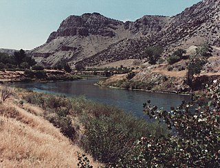
The Wind River is the name applied to the upper reaches of the Bighorn River in Wyoming in the United States. The Wind River is 185 miles (298 km) long. The two rivers are sometimes referred to as the Wind/Bighorn.

Curecanti National Recreation Area is a National Park Service unit located on the Gunnison River in western Colorado. Established in 1965, Curecanti National Recreation Area is responsible for developing and managing recreational facilities on three reservoirs, Blue Mesa Reservoir, Morrow Point Reservoir and Crystal Reservoir, constructed on the upper Gunnison River in the 1960s by the U.S. Bureau of Reclamation to better utilize the vital waters of the Colorado River and its major tributaries. A popular destination for boating and fishing, Curecanti offers visitors two marinas, traditional and group campgrounds, hiking trails, boat launches, and boat-in campsites. The state's premiere lake trout and Kokanee salmon fisheries, Curecanti is a popular destination for boating and fishing, and is also a popular area for ice-fishing in the winter months.
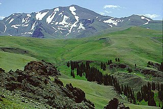
Shoshone National Forest is the first federally protected National Forest in the United States and covers nearly 2,500,000 acres (1,000,000 ha) in the state of Wyoming. Originally a part of the Yellowstone Timberland Reserve, the forest is managed by the United States Forest Service and was created by an act of Congress and signed into law by U.S. President Benjamin Harrison in 1891. Shoshone National Forest is one of the first nationally protected land areas anywhere. Native Americans have lived in the region for at least 10,000 years, and when the region was first explored by European adventurers, forestlands were occupied by several different tribes. Never heavily settled or exploited, the forest has retained most of its wildness. Shoshone National Forest is a part of the Greater Yellowstone Ecosystem, a nearly unbroken expanse of federally protected lands encompassing an estimated 20,000,000 acres (8,100,000 ha).

The San Luis Reservoir is an artificial lake on San Luis Creek in the eastern slopes of the Diablo Range of Merced County, California, approximately 12 mi (19 km) west of Los Banos on State Route 152, which crosses Pacheco Pass and runs along its north shore. It is the fifth largest reservoir in California. The reservoir stores water taken from the San Joaquin-Sacramento River Delta. Water is pumped uphill into the reservoir from the O'Neill Forebay which is fed by the California Aqueduct and is released back into the forebay to continue downstream along the aqueduct as needed for farm irrigation and other uses. Depending on water levels, the reservoir is approximately nine miles (14 km) long from north to south at its longest point, and five miles (8 km) wide. At the eastern end of the reservoir is the San Luis Dam, the fourth largest embankment dam in the United States, which allows for a total capacity of 2,041,000 acre-feet (2,518,000 dam3). Pacheco State Park lies along its western shores.

Dillon Reservoir, sometimes referred to as Lake Dillon, is a large fresh water reservoir located in Summit County, Colorado, United States, south of I-70 and bordered by the towns of Frisco, Silverthorne, and Dillon. It is a reservoir for the city of Denver, and its waters are under the control of Denver Water. Popular ski areas are close to the reservoir, including Copper Mountain, Keystone, Arapahoe Basin, and Breckenridge.

Blue Mesa Reservoir is an artificial reservoir located on the upper reaches of the Gunnison River in Gunnison County, Colorado. The largest lake located entirely within the state, Blue Mesa Reservoir was created by the construction of Blue Mesa Dam, a 390 feet (120 m) tall earthen fill dam constructed on the Gunnison by the U.S. Bureau of Reclamation in 1966 for the generation of hydroelectric power. Managed as part of the Curecanti National Recreation Area, a unit of the National Park Service, Blue Mesa Reservoir is the largest lake trout and Kokanee salmon fishery in Colorado.

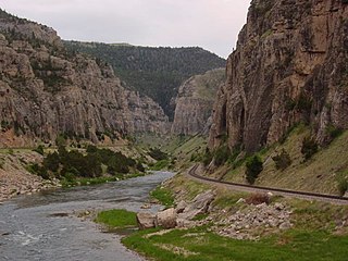
Boysen State Park is a public recreation area surrounding the Boysen Reservoir, an impoundment of the north-flowing Wind River, in Fremont County, Wyoming. The state park covers more than 35,000 acres (14,000 ha) at the south end of the Owl Creek Mountains at the mouth of the Wind River Canyon.

Sinks Canyon State Park is a public recreation and nature preservation area located in the Wind River Mountains, six miles (9.7 km) southwest of Lander, Wyoming, on Wyoming Highway 131. The state park is named for a portion of the Middle Fork of the Popo Agie River where it flows into an underground limestone cavern, named "the Sinks," and emerges a quarter-mile down the canyon in a pool named "the Rise." The park is managed by the Wyoming Division of State Parks and Historic Sites.
McGregor Lake is an elongated reservoir in Southern Alberta. McGregor Lake was created in 1920 by the completion of two dams bracketing water flowing through in Snake Valley. It is situated 100 km (62 mi) southeast of Calgary in the Vulcan County.

The Boysen Dam is a rockfill dam on the Wind River in the U.S. state of Wyoming. The dam lies at the head of Wind River Canyon through the Owl Creek Mountains in western Wyoming and creates Boysen Reservoir. It is owned by the U.S. Bureau of Reclamation and furnishes irrigation water supply to the Bighorn Basin as well as providing flood control and hydroelectric power.