
Point of Rocks is an unincorporated community in Sweetwater County, Wyoming, United States. As of the 2000 census, Point of Rocks had a total population of three, when it was a census-designated place (CDP).
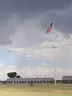
Fort Larned National Historic Site preserves Fort Larned which operated from 1859 to 1878. It is approximately 5.5 miles (8.9 km) west of Larned, Kansas, United States.

Fort Laramie was a significant 19th-century trading post, diplomatic site, and military installation located at the confluence of the Laramie and the North Platte rivers. They joined in the upper Platte River Valley in the eastern part of the U.S. state of Wyoming. The fort was founded as a private trading post in the 1830s to service the overland fur trade; in 1849, it was purchased by the United States Army. It was located east of the long climb leading to the best and lowest crossing point of the Rocky Mountains at South Pass and became a popular stopping point for migrants on the Oregon Trail. Along with Bent's Fort on the Arkansas River, the trading post and its supporting industries and businesses were the most significant economic hub of commerce in the region.

Fort D. A. Russell, also known as Fort Francis E. Warren, Francis E. Warren Air Force Base and Fort David A. Russell, was a post and base of operations for the United States Army, and later the Air Force, located in Cheyenne, Wyoming. The fort had been established in 1867 to protect workers for the Union Pacific Railroad. It was named in honor of David Allen Russell, a Civil War general killed at the Battle of Opequon. In 1930, the fort's name was changed to Fort Francis E. Warren. In 1949, it became Francis E. Warren Air Force Base.

The Laramie Plains is an arid highland at an elevation of approx. 8,000 feet (2,400 m) in south central Wyoming in the United States. The plains extend along the upper basin of the Laramie River on the east side of the Medicine Bow Range. The city of Laramie is the largest community in the valley. The plains are separated from the Great Plains to the east by the Laramie Mountains, a spur of the Front Range that extends northward from Larimer County, Colorado west of Cheyenne. The high altitude of the region makes for a cold climate and a relatively short growing season. Unsuitable to most cultivation, the plains have historically been used for livestock raising, primarily of sheep and cattle.

South Pass City is an unincorporated community in Fremont County, Wyoming, United States. It is located 2 miles (3 km) south of the intersection of highways 28 and 131. A former station on the Oregon Trail, it became a ghost town after later gold mines were closed. The entire community is listed on the National Register of Historic Places. The closest town is Atlantic City. Some people have returned.
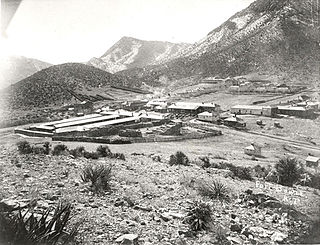
Fort Bowie was a 19th-century outpost of the United States Army located in southeastern Arizona near the present day town of Willcox, Arizona. The remaining buildings and site are now protected as Fort Bowie National Historic Site.

The path followed by the Oregon Trail, California Trail and Mormon Trail spans 400 miles (640 km) through the U.S. state of Wyoming. The trail entered from Nebraska on the eastern border of the state near the present day town of Torrington and exited on the western border near the towns of Cokeville and Afton. An estimated 350,000 to 400,000 settlers traveled on the trail through Wyoming between 1841 and 1868. All three trails follow the same path through most of the state. The Mormon Trail splits at Fort Bridger and enters Utah, while the Oregon and California Trails continue to Idaho.

The Great Platte River Road was a major overland travel corridor approximately following the course of the Platte River in present-day Nebraska and Wyoming that was shared by several popular emigrant trails during the 19th century, including the Trapper's Trail, the Oregon Trail, the Mormon Trail, the California Trail, the Pony Express route, and the military road connecting Fort Leavenworth and Fort Laramie. The road, which extended nearly 800 miles (1,300 km) from the Second Fort Kearny to Fort Laramie, was utilized primarily from 1841 to 1866. In modern times it is often regarded as a sort of superhighway of its era, and has been referred to as "the grand corridor of America's westward expansion".

The Geraldine Lucas–Fabian Place Historic District in Jackson Hole, Wyoming is significant as the 1913 home of Geraldine Lucas, a single woman pioneer in a harsh environment. It later became the home of Harold Fabian, vice president of the Snake River Land Company, which assembled much of the land that became Jackson Hole National Monument for John D. Rockefeller, Jr..
Point of Rocks may refer to:
The Overland Trail was a stagecoach and wagon trail in the American West during the 19th century. While portions of the route had been used by explorers and trappers since the 1820s, the Overland Trail was most heavily used in the 1860s as a route alternative to the Oregon, California, and Mormon trails through central Wyoming. The Overland Trail was famously used by the Overland Stage Company owned by Ben Holladay to run mail and passengers to Salt Lake City, Utah, via stagecoaches in the early 1860s. Starting from Atchison, Kansas, the trail descended into Colorado before looping back up to southern Wyoming and rejoining the Oregon Trail at Fort Bridger. The stage line operated until 1869 when the completion of the First Transcontinental Railroad eliminated the need for mail service via Thais' stagecoach.

Fort Halleck was a military outpost that existed in the 1860s along the Overland Trail and stage route in what was then the Territory of Idaho, now the U.S. state of Wyoming. The fort was established in 1862 to protect emigrant travelers and stages transporting mail between Kansas and Salt Lake City, Utah, and named for Major General Henry Wager Halleck, commander of the Department of the Missouri and later General-in-chief of the Union armies.

The Powder River Crossing, officially known as Powder River Station-Powder River Crossing , is an abandoned settlement located on the east bank of the Powder River in southeast Johnson County about twenty-four miles east of Kaycee, Wyoming. It developed after a wooden toll bridge was built across the Powder River in 1877, at a site that was originally used as a ford. With crossing secured, a settlement developed here in the late 19th century, incorporating a stage stop on the Bozeman Trail. The site is notable for having well-preserved wagon ruts from the pioneer era.
Fort Steele, also known as Fort Fred Steele, was established to protect the newly built Union Pacific Railroad from attacks by Native Americans during construction of the transcontinental railroad in the United States. The fort was built in 1868 where the railroad crossed the North Platte River in Carbon County, Wyoming. Work on the fort was carried out by military and civilian labor. Fort Steele was one of three forts built on the line. Fort Sanders near Laramie and Fort D.A. Russell at Cheyenne were the other railroad forts. Fort Steele was named for the recently deceased General Frederick Steele.
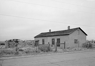
Granger Station State Historic Site, also known as Granger Stage Station, South Bend Station and Ham's Fork Station, is a Wyoming state park dedicated to the interpretation of the station, the Pony Express and the Overland Trail. A settlement was first established about 1856 at the meeting of Ham's Fork with Black's Fork of the Green River, where a ferry crossed Ham's Fork. This became a station on the Pony Express in 1860-1861, then was a station on the Overland Trail in 1862. By this time it was known as the South Bend Station. In 1868 the trail was superseded when the Union Pacific Railroad arrived at the site. The station was deeded to the State of Wyoming in 1930. It is operated as a state historic site. The Granger Station was placed on the National Register of Historic Places on February 26, 1970.

Vallecito, in San Diego County, California is an oasis of cienegas and salt grass along Vallecito Creek and a former settlement on the edge of the Colorado Desert in the Vallecito Valley. Its Spanish name is translated as "little valley". Vallecito was located at the apex of the gap in the Carrizo Badlands created by Carrizo Creek and its wash in its lower reach, to which Vallecito Creek is a tributary. The springs of Vallecito, like many in the vicinity, are a product of the faults that run along the base of the Peninsular Ranges to the west.
Richardson's Overland Trail Ranch is a complex of seven ranch buildings at the crossing of the Big Laramie River by the Overland Trail. The ranch's main residence was built as a stage station for the trail in 1862. A corduroy road was built at the same time. By 1864 ranching became established around the stage station, primarily by Tom Alsop, Edward Creighton and Charlie Hutton. With Creighton's death in 1874 the land was divided between Alsop on the west side of the river and Hutton on the east side. The ranch on the west side became known as the Heart or Hart Ranch. The ranches at the river crossing became part of the larger Riverside Livestock Company.
The Platte River Crossing, also known as Bennett's Crossing, is the point at which the Overland Trail crossed the North Platte River in Carbon County, Wyoming. The site is a natural ford created by an island in the middle of the river with a firm river bottom on either side. The location was used as a ford by Native Americans before the arrival of Europeans in the West. The first Europeans to use the site were members of the William Henry Ashley fur-trading expedition of 1825, followed by John C. Frémont in 1843. In 1850, Howard Stansbury camped at the site, noting the presence of remnant Native American encampments around the site. By the time the Overland Stage Line was established in 1861, the crossing had been used by emigrants for several years. In later years, a ferry was operated at the site by Ed Bennett, leading to the site becoming known as Bennett's Crossing. When the Union Pacific Railway laid tracks through the region in 1868, the crossing fell out of use.
The Dug Springs Station Site is a former way station on the Overland Trail in Sweetwater County, Wyoming. Constructed about 1862, the station was built with rock slab walls, between Laclede Station and Duck Lake Station. The site was placed on the National Register of Historic Places on December 6, 1978.


