Related Research Articles
The Horner Site, also known as the Creek Site and Horner's Corner Site, and designated by the Smithsonian trinomial 48PA29, is an important archaeological site near Cody, Wyoming. It is the type site for the Cody complex. It was declared a National Historic Landmark in 1961.

This is a list of the National Register of Historic Places listings in Park County, Wyoming.

This is a list of the National Register of Historic Places listings in Converse County, Wyoming.
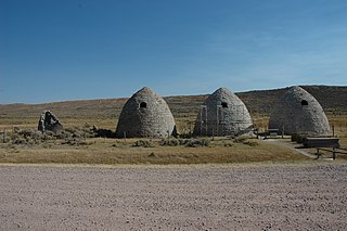
The Piedmont Charcoal Kilns in Piedmont, Wyoming, are a remnant of a once-extensive charcoal-making industry in southwestern Wyoming. The kilns were built by Moses Byrne around 1869 near the Piedmont Station along the Union Pacific Railroad. The three surviving beehive-shaped kilns were built of local sandstone about 30 feet (9.1 m) in circumference and about 30 feet (9.1 m) high, with 24-inch-thick (61 cm) walls. A granite marker reads:
Charcoal Kilns were built by Moses Byrne, 1869, to supply the pioneer smelters in the Utah Valley.
Several sections of the Bozeman Trail in Wyoming are listed on the National Register of Historic Places. Typically there are sections of trail that are concentrated at geographic features such as fords or crossings of divides, where the trail consolidates from a broad swath of parallel, poorly defined paths to a small area where remnants of the trail are visible.

Medicine Lodge State Archeological Site is a Wyoming state park that interprets the Medicine Lodge Creek Site, a prehistoric Native American archeological site near Hyattville, Wyoming. It is administered by the Wyoming Division of State Parks and Historic Sites. The site is at the base of a steep limestone outcropping near the point where the dry and running portions of Medicine Lodge Creek join. for a protected location with ready access to water. The site includes petroglyphs and pictographs on the rock face. Excavations starting in the 1970s have found twelve levels of habitation in 10.5 feet of stratum, ranging from historic times to 8300 years before the present. The site comprises a portion of the former Wickwire Ranch, which was purchased by the state in 1972 and became to Medicine Lodge Wildlife Habitat Management Area of 12,000 acres (4,900 ha). The archeological site was designated in 1973. The site is managed as a state park, with campgrounds and a visitor center. It was added to the National Register of Historic Places on July 5, 1973.
The Garrett Allen Prehistoric Site is an archeological site in Carbon County, Wyoming. The site was used in the Late Middle Prehistoric Period and into the Late Prehistoric Period. The site was used as an animal butchering location. Excavations by George Frison in the late 1960s and early 1970s revealed a continuous series of layers containing tools, stone flakes and projectile points. This site was placed on the National Register of Historic Places on August 7, 1974.
The Sage Creek Station Site is a former way station on the Overland Trail in Carbon County, Wyoming. Constructed about 1862, the station was built of logs with an adobe fireplace and a dirt roof over pole rafters. The site burned on June 8, 1865, but may have been rebuilt. All that remains of the station are its foundations. The site was placed on the National Register of Historic Places on December 6, 1978.
The Midway Station Site is a former way station on the Overland Trail in Carbon County, Wyoming. Built in 1850, the station was on a heavily traveled stage and emigration route, halfway between Saratoga and Walcott, providing its name. Nothing remains of the station beyond depressions in the earth. The site was placed on the National Register of Historic Places on December 6, 1978.
The Pine Grove Station Site is a former way station on the Overland Trail in Carbon County, Wyoming, near Bridger's Pass. It was built in 1862 by Robert Foote for $1500 and was described as a log building about 25 feet (7.6 m) by 60 feet (18 m) with an adjoining corral. The station was burned in 1865 and 1867 by Indians. Nothing remains of the station. The site was placed on the National Register of Historic Places on December 6, 1978.
The Washakie Station Site is a former way station on the Overland Trail in Carbon County, Wyoming. Built in 1862, the station was on a heavily traveled stage and emigration route. The station was a stone structure with a dirt roof over pole rafters. Remains of the station consist of foundations and ruined sandstone walls. The site was placed on the National Register of Historic Places on December 6, 1978.
The Muddy Creek Archeological Complex is an archeological location Carbon County, Wyoming. The complex's three sites are dated to the Late Plains Archaic period. Stone points place the users of the site in the Besant Cultural Complex, representing one of the southernmost Besant sites. The sites were was bison hunting and processing locations and feature many bison remains, as well as tipi rings. The complex was placed on the National Register of Historic Places on May 16, 2012.
The Dug Springs Station Site is a former way station on the Overland Trail in Sweetwater County, Wyoming. Constructed about 1862, the station was built with rock slab walls, between Laclede Station and Duck Lake Station. The site was placed on the National Register of Historic Places on December 6, 1978.
The Dean Decker Site is an archeological site in Sweetwater and Fremont counties in Wyoming. The site extends for 6.5 kilometres (4.0 mi) along the terraces of Red Creek and Lower Sand Creek, with many Native American hearths and worked stone fragments. The site appears to have been used from the Middle Archaic Period to the Protohistoric Period. It was added to the National Register of Historic Places on March 12, 1986.
The Eldon-Wall Terrace Site is an archeological site in Sweetwater County, Wyoming. The site occupies about 600 metres (2,000 ft) of a terrace on Blacks Fork in the Green River Basin. The site includes numerous hearth sites, with stone chips and tools. A projectile point dates the site to the Middle Archaic period. The site was listed on the National Register of Historic Places on December 13, 1985.

The Castle Gardens Petroglyph Site is a 6-mile (9.7 km) by 1-mile (1.6 km) region of vertical cliff faces in Fremont County, Wyoming, United States, with extensive petroglyph images incised in the rock faces. The glyphs include images of water turtles and circular shields, as well as human and animal figures. The figures with circular shields are particular to the area, and are known as Castle Gardens Shield style images. A consensus of researchers is that the figures were carved by Athabaskans related to the Navajo and Apache, some time between 1000 AD and 1250 AD. The site is being developed by the Bureau of Land Management, and may be visited.
The Green Mountain Arrow Site is an assemblage of arranged stones in Fremont County, Wyoming. The site includes seven stone cairns, a 50-metre (160 ft) directional arrow, three possible stone circles and lines of small stones. It is one of relatively few stone effigies found in the northern Great Plans and Rocky Mountains.
The Split Rock Archeological Site comprises a series of river terraces south of the Sweetwater River in Fremont County, Wyoming. The terraces have yielded Native American artifacts from the Early Plains Archaic Period. Several housepit features were found in 1984 excavations. The site was placed on the National Register of Historic Places on May 4, 1987.
The Helen Lookingbill Site is a prehistoric campsite in the Absaroka Mountains of Fremont County, Wyoming. Occupied over 12,500 years, the site has yielded more than 125,000 artifacts, including a large quantity of Early Plains Archaic side-notched points. The site has been assessed as a tool production location.
The Finley Site is an archeological site in Sweetwater County, Wyoming. The site was investigated beginning in 1940 when projectile points were found on the surface by Orion B. Finley in the vicinity of a stable section of the Killpecker Dune Field. The site dates to the late Paleoindian Period of about 9000 years before present. The projectile points from the Finley Site established the Eden point type, and included Scottsbluff Type I and II points, linking the cultures to the Cody Cultural Complex.
References
- 1 2 3 "National Register Information System". National Register of Historic Places . National Park Service. July 9, 2010.
- ↑ "Eden-Farson Site". Wyoming State Historic Preservation Office.