Related Research Articles

The National Register of Historic Places (NRHP) is the United States federal government's official list of sites, buildings, structures, districts, and objects deemed worthy of preservation for their historical significance or "great artistic value".
The Quintin Blair House in Cody, Wyoming, United States, was designed by Frank Lloyd Wright and built 1952–1953. The house is an example of Wright's "natural house" theme, emphasizing close integration of house and landscape. It is the only Wright building in Wyoming.
This is a list of the National Register of Historic Places listings in Crook County, Wyoming.

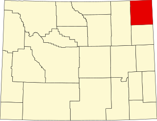
This is a list of the National Register of Historic Places listings in Park County, Wyoming.

This is a list of the National Register of Historic Places listings in Sweetwater County, Wyoming.
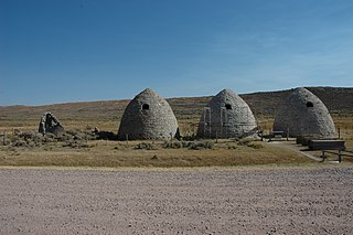
The Piedmont Charcoal Kilns in Piedmont, Wyoming, are a remnant of a once-extensive charcoal-making industry in southwestern Wyoming. The kilns were built by Moses Byrne around 1869 near the Piedmont Station along the Union Pacific Railroad. The three surviving beehive-shaped kilns were built of local sandstone about 30 feet (9.1 m) in circumference and about 30 feet (9.1 m) high, with 24-inch-thick (61 cm) walls. A granite marker reads:
Charcoal Kilns were built by Moses Byrne, 1869, to supply the pioneer smelters in the Utah Valley.

The Point of Rocks Stage Station is a former resting place at the meeting point of the Overland Trail and the Union Pacific Railroad in Sweetwater County, Wyoming, USA. It was built as a stop for the Overland Stage Line in the 1861 or 1862, equidistant between the earlier Black Buttes and Salt Wells stations, which were 28 miles (45 km) apart. The station served the stage line from 1862 to 1868. In 1868, the Union Pacific line reached Point of Rocks, putting the stage line out of business. The station then became a freight depot for nearby mines, with a road leading to Atlantic City and South Pass. The freight activity declined, and in 1877, the station became a residence. At one point it was allegedly inhabited by Jim McKee, a former member of the Hole in the Wall Gang. It became the property of the state of Wyoming in 1947 and is administered as Point of Rocks Stage Station State Historic Site.

Granger Station State Historic Site, also known as Granger Stage Station, South Bend Station and Ham's Fork Station, is a state park in Granger, Wyoming, United States, that is listed on the National Register of Historic Places (NRHP).
Several sections of the Bozeman Trail in Wyoming are listed on the National Register of Historic Places. Typically there are sections of trail that are concentrated at geographic features such as fords or crossings of divides, where the trail consolidates from a broad swath of parallel, poorly defined paths to a small area where remnants of the trail are visible.

Medicine Lodge State Archaeological Site is a Wyoming state park that interprets the Medicine Lodge Creek Site, a prehistoric Native American archaeological site near Hyattville, Wyoming. It is administered by the Wyoming Division of State Parks and Historic Sites. The site is at the base of a steep limestone outcropping near the point where the dry and running portions of Medicine Lodge Creek join for a protected location with ready access to water. The site includes petroglyphs and pictographs on the rock face. An eight-year-long archaeological study beginning in 1968 discovered more than 60 cultural levels. These levels dated from the Paleoindian, Archaic, and Prehistoric periods. The site comprises a portion of the former Wickwire Ranch, which was purchased by the state in 1972 and is now about 12,000 acres (4,900 ha) of Medicine Lodge Wildlife Habitat Management Area. The archaeological site was designated in 1973. It was added to the National Register of Historic Places on July 5, 1973. The site is managed as a state park. Amenities include day-use areas, campgrounds, a visitor center, and an immersive cultural experience.
The Duck Lake Station Site is a former way station on the Overland Trail in Carbon County, Wyoming. Built in 1862, the site is located between the Dug Springs Station to the west and the Washakie Station to the east. Stations on the trail were typically about 15 miles (24 km) apart with the largest, most elaborate stations at 50-mile (80 km) intervals. The Duck Lake station was a more basic one-room building. All that remains of the station are its foundations. The site was placed on the National Register of Historic Places on December 6, 1978.
The Sage Creek Station Site is a former way station on the Overland Trail in Carbon County, Wyoming. Constructed about 1862, the station was built of logs with an adobe fireplace and a dirt roof over pole rafters. The site burned on June 8, 1865, but may have been rebuilt. All that remains of the station are its foundations. The site was placed on the National Register of Historic Places on December 6, 1978.
The Midway Station Site is a former way station on the Overland Trail in Carbon County, Wyoming. Built in 1850, the station was on a heavily traveled stage and emigration route, halfway between Saratoga and Walcott, providing its name. Nothing remains of the station beyond depressions in the earth. The site was placed on the National Register of Historic Places on December 6, 1978.
The Pine Grove Station Site is a former way station on the Overland Trail in Carbon County, Wyoming, near Bridger's Pass. It was built in 1862 by Robert Foote for $1500 and was described as a log building about 25 feet (7.6 m) by 60 feet (18 m) with an adjoining corral. The station was burned in 1865 and 1867 by Indians. Nothing remains of the station. The site was placed on the National Register of Historic Places on December 6, 1978.
The Washakie Station Site is a former way station on the Overland Trail in Carbon County, Wyoming. Built in 1862, the station was on a heavily traveled stage and emigration route. The station was a stone structure with a dirt roof over pole rafters. Remains of the station consist of foundations and ruined sandstone walls. The site was placed on the National Register of Historic Places on December 6, 1978.
The Laclede Station Ruin is a former way station on the Overland Trail in Sweetwater County, Wyoming, between the Big Pond Station and the Dug Springs Station. Constructed in the 1860s, the station was built of stone slabs. The ruins of some of its walls remain. The site was placed on the National Register of Historic Places on December 6, 1978.
The Dean Decker Site is an archeological site in Sweetwater and Fremont counties in Wyoming. The site extends for 6.5 kilometres (4.0 mi) along the terraces of Red Creek and Lower Sand Creek, with many Native American hearths and worked stone fragments. The site appears to have been used from the Middle Archaic Period to the Protohistoric Period. It was added to the National Register of Historic Places on March 12, 1986.
High Rise Village is a high-elevation archeological site in Fremont County, Wyoming. Discovered in 2006 in the Wind River Range in Shoshone National Forest, the location features almost sixty lodge pads and has yielded more than 30,000 artifacts from the Archaic to the Protohistoric Period, a period of over 2500 years. The site is at 3,500 metres (11,500 ft) elevation and represents a major discovery of prehistoric occupation of high elevation zones, which had previously been neglected in archeological studies in the Western United States. High Rise Village and other similar locations share an association with stands of whitebark pines, an abundant food source.
T Cross Ranch is a dude ranch in Fremont County, Wyoming. The ranch is located at 7,800 feet (2,400 m) altitude in Shoshone National Forest, 15 miles (24 km) from Dubois and 2 miles (3.2 km) from the Washakie Wilderness. Apart from a cabin built by the site's original homesteader, the contributing buildings of the ranch date between 1916 and 1946. The ranch was established in 1918 by German immigrant Henry Seipt when he established his homestead and called it The Hermitage. Seipt and his family ran the ranch as a hunting and fishing camp until 1929, when it was sold to Robert and Helen Cox. The Coxes renamed it the T Cross Ranch and made it into a dude ranch. The new name was derived from the Tau Chapter of Saint Anthony's Society, to which Robert Cox had belonged at the Massachusetts Institute of Technology, and from the cross of St. Anthony. A total of 16 log buildings comprise the historic section of the ranch. The district also includes irrigation ditches dug during the 1920s and 1930s.
The Eden-Farson Site is an archeological site in Sweetwater County, Wyoming. The site was a Native American campground dated to the Protohistoric period. The site is noted for the large collection of pronghorn bones, along with at least twelve lodge sites.
References
- 1 2 "National Register Information System". National Register of Historic Places . National Park Service. July 9, 2010.
- ↑ "Dug Springs Station Site". Wyoming State Historic Preservation Office. Archived from the original on February 23, 2018. Retrieved February 23, 2018.