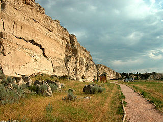
Register Cliff is a sandstone cliff and featured key navigational landmark prominently listed in the 19th century guidebooks about the Oregon Trail, and a place where many emigrants chiseled the names of their families on the soft stones of the cliff — it was one of the key checkpoint landmarks for parties heading west along the Platte River valley west of Fort John, Wyoming which allowed travelers to verify they were on the correct path up to South Pass and not moving into impassable mountain terrains—geographically, it is on the eastern ascent of the Continental divide leading upward out of the great plains in the east of the U.S. state of Wyoming. It is notable as a historic landmark for 'registering' hundreds of emigrants on the Oregon Trail who came to follow custom and inscribed their names on its rocks during the western migrations of the 19th century. An estimated 500,000 emigrants used these trails from 1843–1869, with up to one-tenth dying along the way, usually due to disease.

The Moran Bay Patrol Cabin was built by the Civilian Conservation Corps about 1932. The log structure was located in the northern backcountry of Grand Teton National Park, and was built to a standard design for such structures, in the National Park Service Rustic style, but for the U.S. Forest Service, which administered much of the area prior to the expansion of the park in 1943. The Upper Granite Canyon Patrol Cabin is similar.
The Squirrel Meadow Guard Station is a ranger station in the backcountry of Targhee National Forest in Wyoming. The original facility was established in 1907, with the present structures built in 1934. The log cabin station is an example of a standard US Forest Service backcountry patrol structure.
The Quintin Blair House in Cody, Wyoming was designed by Frank Lloyd Wright and built in 1952-53. The house is an example of Wright's "natural house" theme, emphasizing close integration of house and landscape. It is the only Wright building in Wyoming.
The Dead Indian Campsite is an archeological site in the Sunlight Basin of the Absaroka Mountains in Park County, Wyoming, United States. The site was found during the construction of the Sunlight Basin Road in 1967. The location was used as a butchering site, and excavations by the University of Wyoming in 1969 uncovered numerous stone tools, as well as the bones of elk, deer, mountain sheep, porcupine and wolf. A stone cairn was found to contain antler sets. The site was used in different eras for 4500 years.
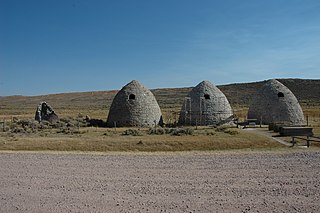
The Piedmont Charcoal Kilns in Piedmont, Wyoming, are a remnant of a once-extensive charcoal-making industry in southwestern Wyoming. The kilns were built by Moses Byrne around 1869 near the Piedmont Station along the Union Pacific Railroad. The three surviving beehive-shaped kilns were built of local sandstone about 30 feet (9.1 m) in circumference and about 30 feet (9.1 m) high, with 24-inch-thick (61 cm) walls. A granite marker reads:
Charcoal Kilns were built by Moses Byrne, 1869, to supply the pioneer smelters in the Utah Valley.
The Garrett Allen Prehistoric Site is an archeological site in Carbon County, Wyoming. The site was used in the Late Middle Prehistoric Period and into the Late Prehistoric Period. The site was used as an animal butchering location. Excavations by George Frison in the late 1960s and early 1970s revealed a continuous series of layers containing tools, stone flakes and projectile points. This site was placed on the National Register of Historic Places on August 7, 1974.
The Duck Lake Station Site is a former way station on the Overland Trail in Carbon County, Wyoming. Built in 1862, the site is located between the Dug Springs Station to the west and the Washakie Station to the east. Stations on the trail were typically about 15 miles (24 km) apart with the largest, most elaborate stations at 50-mile (80 km) intervals. The Duck Lake station was a more basic one-room building. All that remains of the station are its foundations. The site was placed on the National Register of Historic Places on December 6, 1978.
The Sage Creek Station Site is a former way station on the Overland Trail in Carbon County, Wyoming. Constructed about 1862, the station was built of logs with an adobe fireplace and a dirt roof over pole rafters. The site burned on June 8, 1865, but may have been rebuilt. All that remains of the station are its foundations. The site was placed on the National Register of Historic Places on December 6, 1978.
The Midway Station Site is a former way station on the Overland Trail in Carbon County, Wyoming. Built in 1850, the station was on a heavily traveled stage and emigration route, halfway between Saratoga and Walcott, providing its name. Nothing remains of the station beyond depressions in the earth. The site was placed on the National Register of Historic Places on December 6, 1978.
The Pine Grove Station Site is a former way station on the Overland Trail in Carbon County, Wyoming, near Bridger's Pass. It was built in 1862 by Robert Foote for $1500 and was described as a log building about 25 feet (7.6 m) by 60 feet (18 m) with an adjoining corral. The station was burned in 1865 and 1867 by Indians. Nothing remains of the station. The site was placed on the National Register of Historic Places on December 6, 1978.
The Washakie Station Site is a former way station on the Overland Trail in Carbon County, Wyoming. Built in 1862, the station was on a heavily traveled stage and emigration route. The station was a stone structure with a dirt roof over pole rafters.Remains of the station consist of foundations and ruined sandstone walls. The site was placed on the National Register of Historic Places on December 6, 1978.
The Muddy Creek Archeological Complex is an archeological location Carbon County, Wyoming. The complex's three sites are dated to the Late Plains Archaic period. Stone points place the users of the site in the Besant Cultural Complex, representing one of the southernmost Besant sites. The sites were was bison hunting and processing locations and feature many bison remains, as well as tipi rings.The complex was placed on the National Register of Historic Places on May 16, 2012.
The Laclede Station Ruin is a former way station on the Overland Trail in Sweetwater County, Wyoming, between the Big Pond Station and the Dug Springs Station. Constructed in the 1860s, the station was built of stone slabs. The ruins of some of its walls remain. The site was placed on the National Register of Historic Places on December 6, 1978.
The Dug Springs Station Site is a former way station on the Overland Trail in Sweetwater County, Wyoming. Constructed about 1862, the station was built with rock slab walls, between Laclede Station and Duck Lake Station. The site was placed on the National Register of Historic Places on December 6, 1978.
The Arapahoe and Lost Creek Site is an archeological site in Sweetwater County, Wyoming. Site includes evidence of settlement over a 9 kilometres (5.6 mi) stretch along the terraces of Arapahoe Creek and Lost Creek. The site was used by Native Americans more or less continuously for 9000 years until about 1900. Site surveys indicate the presence of at least three dozen hearths, and buried features are believed to exist. The site was placed on the National Register of Historic Places on March 12, 1986.
The Dean Decker Site is an archeological site in Sweetwater and Fremont counties in Wyoming. The site extends for 6.5 kilometres (4.0 mi) along the terraces of Red Creek and Lower Sand Creek, with many Native American hearths and worked stone fragments. The site appears to have been used from the Middle Archaic Period to the Protohistoric Period. It was added to the National Register of Historic Places on March 12, 1986.
The Green Mountain Arrow Site is an assemblage of arranged stones in Fremont County, Wyoming. The site includes seven stone cairns, a 50-metre (160 ft) directional arrow, three possible stone circles and lines of small stones. It is one of relatively few stone effigies found in the northern Great Plans and Rocky Mountains.
The Split Rock Archeological Site comprises a series of river terraces south of the Sweetwater River in Fremont County, Wyoming. The terrraces have yielded Native American artifacts from the Early Plains Archaic Period. Several housepit features were found in 1984 excavations. The site was placed on the National Register of Historic Places on May 4, 1987..
The Finley Site is an archeological site in Sweetwater County, Wyoming. The site was investigated beginning in 1940 when projectile points were found on the surface by Orion B. Finley in the vicinity of a stable section of the Killpecker Dune Field. The site dates to the late Paleoindian Period of about 9000 years before present. The projectile points from the Finley Site established the Eden point type, and included Scottsbluff Type I and II points, linking the cultures to the Cody Cultural Complex.


