
Absaroka–Beartooth Wilderness was created from existing National Forest lands in 1978 and is located in Montana and Wyoming, United States. The wilderness encompasses two distinct mountain ranges: the Beartooth and Absaroka ranges. These ranges are completely distinct geologically speaking, with the Absaroka composed primarily of volcanic and metamorphic rock, while the Beartooth is made up almost entirely of granitic rocks. The Absaroka are noted for their dark and craggy appearance, lush and heavily forested valleys, and abundant wildlife. The highest peak in the range, in Wyoming, is Francs Peak at 13,153 feet (4,009 m). The Beartooth is more alpine, with huge treeless plateaus and the highest peak of Montana. The wilderness has more than 120 peaks over 10,000 feet (3,000 m) and 28 peaks over 12,000 feet (3,700 m), including Montana's highest, Granite Peak at 12,799 feet (3,901 m). The wilderness is integral to the 20-million-acre (81,000 km2) Greater Yellowstone Ecosystem and borders Yellowstone National Park.

The Great Bear Wilderness is located in northern Montana, United States, within Flathead National Forest Created by an act of Congress in 1978, the wilderness comprises 286,700 acres (1,160 km2) and borders the Bob Marshall Wilderness on the north. The Great Bear and Bob Marshall Wildernesses, along with the Scapegoat Wilderness which borders the Bob Marshall to the south, collectively form the Bob Marshall Wilderness Complex, which is over 1.5 million acres (6,100 km2) of almost untouched landscape. Glacier National Park is separated from the Great Bear Wilderness by U.S. Highway 2.
The Washakie Wilderness is located in Shoshone National Forest in the U.S. state of Wyoming.

The Cloud Peak Wilderness is located in north central Wyoming in the United States. Entirely within Bighorn National Forest, the wilderness was established in 1984 in an effort to preserve the wildest section of the Bighorn Mountains. The wilderness has the highest peaks in the Bighorn Mountains including Cloud Peak and Black Tooth Mountain, as well as Cloud Peak Glacier, the only remaining active glacier in the Bighorn Mountains. The Cloud Peak Wilderness is 189,039 acres (765.01 km2).
The Encampment River Wilderness is a designated wilderness area located in south central Wyoming in the United States. Entirely within Medicine Bow National Forest, the wilderness was designated to increase protection of the Encampment River and the canyon through which it flows.
The Huston Park Wilderness is located in south central Wyoming in the United States. Entirely within Medicine Bow National Forest, the wilderness was designated in 1984 to preserve the northernmost section of the central Rocky Mountains, an area of high mountain peaks and coniferous forest.
The Savage Run Wilderness is located in south central Wyoming in the United States. Entirely within Medicine Bow National Forest, the wilderness was designated in 1978 in an effort to protect vital rangeland for a large elk population.

The Jedediah Smith Wilderness is located in the U.S. state of Wyoming. Designated wilderness by Congress in 1984, Jedediah Smith Wilderness is within Caribou-Targhee National Forest and borders Grand Teton National Park. Spanning along the western slopes of the Teton Range, the wilderness ensures a high level of protection to this delicate ecosystem. Jedediah Smith Wilderness is an integral part of the Greater Yellowstone Ecosystem.
The Winegar Hole Wilderness is located in the U.S. state of Wyoming. Designated wilderness by Congress in 1984, the wilderness is within Caribou-Targhee National Forest and borders Yellowstone National Park. The wilderness was created to further protect what is considered to be prime grizzly bear habitat. The wilderness is an integral part of the Greater Yellowstone Ecosystem.
The Cabinet Mountains Wilderness, created by an act of Congress in 1964, is located in the U.S. state of Montana. Protecting the wildest portions of the Cabinet Mountains and an integral part of Kootenai National Forest and Kaniksu National Forest, the wilderness had enjoyed more limited protection since 1935 as a Primitive Area.

The Gates of the Mountains Wilderness is located in the U.S. state of Montana. Created by an act of Congress in 1964, the wilderness is managed by Helena National Forest. A day use campground near the Gates of the Mountains, Meriwether Picnic site, is named in honor of Meriwether Lewis.
The Medicine Lake Wilderness is located in eastern Montana, in the United States. Preserved to ensure migratory birds have a haven during the spring and fall migrations, the wilderness is managed by the U.S. Fish and Wildlife Service and is within Medicine Lake National Wildlife Refuge.

The Mission Mountains Wilderness is located in the U.S. state of Montana. Created by an act of Congress in 1975, the wilderness is within the Swan Lake Ranger District of the Flathead National Forest.
The Rattlesnake Wilderness is located in the U.S. state of Montana. Created by an act of Congress in 1980, the wilderness is within Lolo National Forest and is located only 4 miles (6.5 km) north of Missoula, Montana. The wilderness area is a component of the Rattlesnake National Recreation Area. It protects much of the high country of the Rattlesnake Mountains.
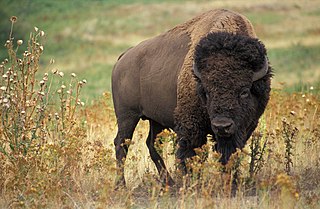
The Fort Niobrara Wilderness is located in the U.S. state of Nebraska, near Valentine. Created by an act of Congress in 1976, the wilderness is managed by the U.S. Fish and Wildlife Service and covers an area of 4,635 acres (18.75 km2) within Fort Niobrara National Wildlife Refuge. The wilderness lies along the northern banks of the Niobrara River, providing sanctuary to bison, prairie dogs, mule deer, river otter and the bald eagle. A mixture of flat prairie and wooded ravines, there are no maintained trails in the wilderness. Access is only allowed during daylight hours and there is no camping or fires allowed.

Soldier Creek Wilderness is located in the U.S. state of Nebraska. Created by an act of Congress in 1986, the wilderness is managed by the U.S. Forest Service and covers an area of 7,794 acres (31.54 km2) within the Pine Ridge section of the Nebraska National Forest. The wilderness experienced a large wildfire in 1989, which destroyed almost 90 percent of the ponderosa pine forest, which today is slowly rebounding. The Bald eagle can be found here, as can white-tailed deer, mule deer, bobcats, coyotes and numerous other mammals. The region, which was originally established as a timber reservation for nearby Fort Robinson, was utilized by the U.S. Cavalry from the late 19th century through World War II for its excellent horse pastures along Soldier Creek. A series of trails pass two windmills that are still functioning, even though they are not maintained and are over 100 years old. A popular destination for horseback riding, the wilderness is the larger of the two federally-designated wilderness areas in Nebraska.

The Black Elk Wilderness is a nature preserve located in the U.S. state of South Dakota. The wilderness was designated by an act of Congress in 1980. Managed by the U.S. Forest Service, Black Elk Wilderness is part of Black Hills National Forest. This 13,426 acre (54 km2) region is considered sacred to Native Americans, especially the Sioux and is named after Black Elk, an Oglala Sioux holy man. Mount Rushmore National Memorial is immediately to the north and much of the rest of the wilderness is bordered by other protected land under the jurisdiction of state and federal agencies.
Lostwood Wilderness is a wilderness area located in the U.S. state of North Dakota. Created by an act of Congress in 1975, the wilderness covers an area of 5,577 acres (22.56 km2). Contained within Lostwood National Wildlife Refuge, the wilderness is managed by the U.S. Fish and Wildlife Service.
The Black Fork Mountain Wilderness Area is located in the U.S. states of Arkansas and Oklahoma. Created by an act of Congress in 1984, the wilderness covers an area of 13,139 acres (53 km²). The Arkansas portion contains 8,430 acres (34.1 km2) and the Oklahoma portion contains 5,140 acres (20.8 km2). Located within Ouachita National Forest, the wilderness is managed by the U.S. Forest Service. The area is about 2 miles (3.2 km) north of Page, Oklahoma, and about 6 miles (9.7 km) north of Mena, Arkansas.
The Upper Kiamichi River Wilderness is located in the U.S. state of Oklahoma. Created by an act of Congress in 1988, the wilderness covers an area of 9,754 acres (39.47 km2). Contained within Ouachita National Forest, the wilderness is managed by the U.S. Forest Service.

