Cokeville Meadows National Wildlife Refuge

Last updated
Cokeville Meadows National Wildlife Refuge
IUCN category IV (habitat/species management area)
Cokeville Meadows NWR Mule Deer.jpg
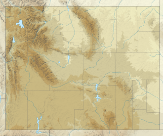
USA Wyoming relief location map.svg
Red pog.svg
Usa edcp relief location map.png
Red pog.svg
Location Lincoln County, Wyoming, United States
Nearest city Cokeville, Wyoming
Coordinates 41°57′N110°59′W / 41.950°N 110.983°W / 41.950; -110.983
Area26,657 acres (107 km2)
Established1993
Governing body U.S. Fish and Wildlife Service
Website Cokeville Meadows National Wildlife Refuge

Cokeville Meadows National Wildlife Refuge is a National Wildlife Refuge of the United States located in Wyoming. It is managed by the U.S. Fish and Wildlife Service, an agency within the U.S. Department of the Interior.

The refuge occupies 26,657 acres (106 km2) of wetlands along a 20 mile (32 km) stretch of the Bear River that is regarded as the finest redhead duck habitat in the region, and one of the best migratory bird sanctuaries in Wyoming. Other bird species known to inhabit the refuge include white-faced ibis, snowy egret, long-billed curlew, great blue heron, American bittern, and black-crowned night heron. bald and golden eagles as well as peregrine falcons nest on the refuge in spring and fall.

Cokeville Meadows is currently closed to the public except for a wildlife viewing station, because it is new and has no visitor services. Less than a third of the designated refuge lands are under U.S. Government administration, and the rest will be purchased from private landowners who agree to sell. The refuge is managed from the Seedskadee National Wildlife Refuge.

The refuge is located adjacent to U.S. Route 30, 1 mile (1.6 km) south of Cokeville, Wyoming.
Related Research Articles

<span class="mw-page-title-main">Pelican Island National Wildlife Refuge</span> United States National Wildlife Refuge in Florida

Pelican Island National Wildlife Refuge is a United States National Wildlife Refuge (NWR), and part of the Everglades Headwaters NWR complex, located just off the western coast of North Hutchinson Island in the Indian River Lagoon east of Sebastian, Florida. The refuge consists of a 3-acre (12,000 m2) island that includes an additional 2.5 acres (10,000 m2) of surrounding water and is located off the east coast of Florida of the Indian River Lagoon. Established by an executive order of President Theodore Roosevelt on March 14, 1903, Pelican Island was the first National wildlife refuge in the United States. It was created to protect egrets and other birds from extinction through plume hunting.

<span class="mw-page-title-main">Iroquois National Wildlife Refuge</span> Wildlife Refuge located in Genesee and Orleans County, NY

The Iroquois National Wildlife Refuge is a wildlife refuge in Genesee and Orleans counties in western New York. The refuge is located between the cities of Buffalo and Rochester and is operated by the United States Fish and Wildlife Service.

<span class="mw-page-title-main">Great Meadows National Wildlife Refuge</span> River wetlands conservation area in Massachusetts

The Great Meadows National Wildlife Refuge is a 12-mile-long (19 km) river wetlands conservation area, in two major parcels, stretching from the towns of Billerica, Massachusetts (downstream) to Wayland, Massachusetts (upstream), along the Concord River and Sudbury River.

<span class="mw-page-title-main">Alamosa National Wildlife Refuge</span> Wildlife refuge in Colorado, US

The Alamosa National Wildlife Refuge is an 11,169-acre (4,520 ha) United States National Wildlife Refuge located in southern Colorado. The site is located in the San Luis Valley along the east side of the Rio Grande approximately 8 miles (13 km) southeast of Alamosa primarily in southeastern Alamosa County, although very small parts extend into northeastern Conejos and western Costilla counties. It is managed by the United States Fish and Wildlife Service jointly with the Baca and Monte Vista National Wildlife Refuges. It was established in 1962 as a haven for migratory birds and other wildlife.

<span class="mw-page-title-main">Arapaho National Wildlife Refuge</span>

The Arapaho National Wildlife Refuge is a United States National Wildlife Refuge located in north-central Colorado. It is one of over 560 national wildlife refuges which manages and protects natural resources for future generations. The refuge is located in North Park in central Jackson County south of the town of Walden. The refuge was established in 1967 to furnish waterfowl with a suitable place to nest and rear their young. It was created in part to offset losses of nesting habitat in the prairie wetland region of the Midwest. It is located in the valley of the Illinois River, a tributary of the North Platte River. It is administered by the United States Fish and Wildlife Service.

<span class="mw-page-title-main">Ridgefield National Wildlife Refuge</span> Wildlife refuge in Washington, U.S.

Ridgefield National Wildlife Refuge is a National Wildlife Refuge and is overseen by the United States Fish and Wildlife Service. The refuge borders the Columbia River and is located west of the city of Ridgefield, Washington. The wildlife haven is split by Lake River. The refuge, which provides a year-round habitat and a migration stop for a variety of bird species, protects more than 5,200 acres (2,100 ha) of marshes, grasslands, and woodlands

Bowdoin National Wildlife Refuge is a 15,551-acre (6,293 ha) National Wildlife Refuge (NWR) located in the north-central region of the U.S. state of Montana. The refuge is 7 mi (11 km) northeast of Malta, Montana in the Milk River Valley and is managed by the U.S. Fish and Wildlife Service.

<span class="mw-page-title-main">Lost Trail National Wildlife Refuge</span>

Lost Trail National Wildlife Refuge is a 8,834-acre (3,575 ha) National Wildlife Refuge of the United States located in Montana. Established in 1999, it is one of the newest National Wildlife Refuges in the U.S. and is managed by the U.S. Fish and Wildlife Service, an agency of the U.S. Department of the Interior. The refuge was originally a sprawling horse and cattle ranch dating back to the late 19th century and was known as the Lost Trail Ranch. The refuge consists of prairie and wetlands, and has a wide diversity of plant and animal species, including over 100 species of birds such as canada geese, sandhill crane, wood duck, green-winged teals and herons. Several species of grouse also inhabit the refuge. Predatory bird species such as the great horned owl and red-tailed hawk are also found here.

<span class="mw-page-title-main">Ninepipe National Wildlife Refuge</span> Protected area in Montana, United States

Ninepipe National Wildlife Refuge is a 4,027-acre (1,630 ha) National Wildlife Refuge and unit of the National Bison Range Complex, located in Lake County, Montana.

<span class="mw-page-title-main">Seedskadee National Wildlife Refuge</span>

Seedskadee National Wildlife Refuge is a National Wildlife Refuge of the United States located in western Sweetwater County in the state of Wyoming. It covers 26,400 acres (106 km2) managed by the U.S. Fish and Wildlife Service, an agency within the U.S. Department of the Interior.

Pathfinder National Wildlife Refuge is located in the U.S. state of Wyoming and includes 16,807 acres (68 km2). The refuge is managed by the U.S. Fish and Wildlife Service and the U.S. Bureau of Reclamation, both agencies within the U.S. Department of the Interior. The refuge is divided into four sections adjacent to Pathfinder Reservoir and includes three campgrounds and three boat ramps. It is located in southern Natrona and northern Carbon counties. Pathfinder NWR is managed from the Arapaho National Wildlife Refuge which is located in Colorado.

North Platte National Wildlife Refuge is located in the U.S. state of Nebraska and includes 5,047 acres (20.42 km2). Managed by the U.S. Fish and Wildlife Service, the refuge is broken into four separate sections that are superimposed on U.S. Bureau of Reclamation–managed lakes and reservoirs. Together with the Crescent Lake National Wildlife Refuge, the two refuges form the Crescent Lake National Wildlife Refuge Complex.

<span class="mw-page-title-main">Cape May National Wildlife Refuge</span> Wildlife habitat in New Jersey, USA

The Cape May National Wildlife Refuge is a protected area on the Cape May Peninsula in Cape May County, New Jersey. It is part of the National Wildlife Refuge System and managed by the United States Fish and Wildlife Service. Established in January 1989 with 90 acres (0.36 km2) acquired from the Nature Conservancy, it has since grown to more than 11,000 acres (45 km2) in size, and plans call for its further expansion to more than 21,200 acres (86 km2). It comprises three distinct and non-contiguous units: the Delaware Bay Division, the Great Cedar Swamp Division and the Two Mile Beach Unit. Located in the Middle Atlantic coastal forests ecoregion, the cape provides habitat for large numbers of migratory birds.

The Stewart B. McKinney National Wildlife Refuge is a 950-acre (384.5 ha) National Wildlife Refuge in ten units across the U.S. state of Connecticut. Located in the Atlantic Flyway, the refuge spans 70 miles (110 km) of Connecticut coastline and provides important resting, feeding, and nesting habitat for many species of wading birds, shorebirds, songbirds and terns, including the endangered roseate tern. Adjacent waters serve as wintering habitat for brant, scoters, American black duck, and other waterfowl. Overall, the refuge encompasses over 900 acres (364.2 ha) of barrier beach, intertidal wetland and fragile island habitats.

<span class="mw-page-title-main">Arrowwood National Wildlife Refuge</span> Protected area in North Dakota, US

Arrowwood National Wildlife Refuge is located in the U.S. state of North Dakota. Arrowwood NWR is a part of the Arrowwood National Wildlife Refuge Complex, and is managed by the U.S. Fish and Wildlife Service. The refuge parallels 16 miles (27 km) of the James River and is a mixture of wetlands, forest and prairie. Efforts to ensure the refuge continues to provide prime nesting habitat for waterfowl include prescribed fire, haying, crop cultivation and livestock grazing. The refuge has forests with oak and hackberry which are uncommon on the prairie. It is believed that the name for the refuge is derived from Native American naming for arrow wood, as the wood in the forest was prized for the making of arrows.

<span class="mw-page-title-main">Baskett Slough National Wildlife Refuge</span>

Baskett Slough National Wildlife Refuge is in northwestern Oregon, 10 miles (16 km) west of Salem in Polk County. The Refuge consists of 1,173 acres (4.75 km²) of cropland, which provide forage for wintering geese, 300 acres (1.2 km²) of forests, 550 acres (2.2 km²) of grasslands, and 500 acres (2.0 km²) of shallow water seasonal wetlands and 35 acres (0.14 km²) of permanent open water. In 1965, Baskett Slough National Wildlife Refuge was created to help ensure some of the original habitat remained for species preservation. The refuge is managed by the U.S. Fish and Wildlife Service, an agency of the U.S. Department of the Interior.

<span class="mw-page-title-main">Tualatin River National Wildlife Refuge</span> Wetlands and lowlands sanctuary in the U.S. state of Oregon

The Tualatin River National Wildlife Refuge is a 1,856 acres (751 ha) wetlands and lowlands sanctuary in the northwestern part of the U.S. state of Oregon. Established in 1992 and opened to the public in 2006, it is managed by the United States Fish and Wildlife Service. Located in southeastern Washington County, 15 miles (24 km) southwest of Portland, the refuge is bordered by Sherwood, Tualatin and Tigard. A newer area, extending into northern Yamhill County, is located further west near the city of Gaston surrounding the former Wapato Lake.

<span class="mw-page-title-main">Lake Ilo National Wildlife Refuge</span> Wildlife refuge

Lake Ilo National Wildlife Refuge (NWR) is located in the U.S. state of North Dakota and is managed from Audubon National Wildlife Refuge by the U.S. Fish and Wildlife Service. The refuge consists of Lake Ilo, surrounding wetlands and some upland range, providing habitat for hundreds of species of birds, and numerous fish and mammal species. An average of over 16 inches (40 cm) of precipitation falls annually, supporting a prairie ecosystem.

<span class="mw-page-title-main">Blackwater National Wildlife Refuge</span> Waterfowl sanctuary in Maryland, U.S.

The Blackwater National Wildlife Refuge was established in 1933 as a waterfowl sanctuary for birds migrating along the critical migration highway called the Atlantic Flyway. The refuge is located on Maryland's Eastern Shore, just 12 mi (19 km) south of Cambridge, Maryland in Dorchester County, and consists of over 28,000 acres (110 km2) of freshwater impoundments, brackish tidal wetlands, open fields, and mixed evergreen and deciduous forests. Blackwater NWR is one of over 540 units in the National Wildlife Refuge System, which is managed by the United States Fish and Wildlife Service.

<span class="mw-page-title-main">Occoquan Bay National Wildlife Refuge</span> United States National Wildlife Refuge in Virginia

The Occoquan Bay National Wildlife Refuge is a National Wildlife Refuge located where the Occoquan River meets the Potomac River in Woodbridge, Virginia, United States between Belmont Bay and Occoquan Bay. The 644-acre (2.61 km2) site, about half of which is wetlands, was a popular tourist spot known as Dawson Beach until the 1940s, after which it was used for military research by the U.S. Army's Harry Diamond Laboratories from the 1960s to the 1990s. When the land was purchased from the military, it was temporarily called the Marumsco National Wildlife Refuge. The refuge was formally established and renamed in 1998, and is now managed by the United States Fish and Wildlife Service as part of the Potomac River National Wildlife Refuge Complex.

References