Hot Springs County is a county in the U.S. state of Wyoming. As of the 2020 United States Census, the population was 4,696, making it the second-least populous county in Wyoming. Its county seat is Thermopolis. The county is named for the hot springs located in Hot Springs State Park.

Fremont County is a county in the U.S. state of Wyoming. As of the 2020 United States Census, the population was 39,234, making it the fifth-most populous county in Wyoming. Its county seat is Lander. The county was founded in 1884 and is named for John C. Frémont, a general, explorer, and politician. It is roughly the size of the state of Vermont.

Hot Springs State Park is a public recreation area in Thermopolis, Wyoming, known for its hot springs, which flow at a constant temperature of 135 °F (57.2 °C). The state park offers free bathing at the State Bath House, where temperatures are moderated to a therapeutic 104 °F (40.0 °C). The petroglyph site at Legend Rock, some 25 miles away, is also part of the park. The park is managed by the Wyoming Division of State Parks and Historic Sites.

The Bridger Trail, also known as the Bridger Road and Bridger Immigrant Road, was an overland route connecting the Oregon Trail to the gold fields of Montana. Gold was discovered in Virginia City, Montana in 1863, prompting settlers and prospectors to find a trail to travel from central Wyoming to Montana. In 1863, John Bozeman and John Jacobs scouted the Bozeman Trail, which was a direct route to the Montana gold fields through the Powder River Country. At the time the region was controlled by the Sioux, Cheyenne and Arapaho, who stepped up their raids in response to the stream of settlers along the trail.

Coso Rock Art District is a rock art site containing over 100,000 Petroglyphs by Paleo-Indians and/or Native Americans. The district is located near the towns of China Lake and Ridgecrest, California. Big and Little Petroglyph Canyons were declared a National Historic Landmark in 1964. In 2001, they were incorporated into this larger National Historic Landmark District. There are several other distinct canyons in the Coso Rock Art District besides the Big and Little Petroglyph Canyons. Also known as Little Petroglyph Canyon and Sand Tanks, Renegade Canyon is but one of several major canyons in the Coso Range, each hosting thousands of petroglyphs. The majority of the Coso Range images fall into one of six categories: bighorn sheep, entopic images, anthropomorphic or human-like figures, other animals, weapons & tools, and "medicine bag" images. Scholars have proposed a few potential interpretations of this rock art. The most prevalent of these interpretations is that they could have been used for rituals associated with hunting.

Guernsey State Park is a public recreation area surrounding the Guernsey Reservoir, an impoundment of the North Platte River, one mile northwest of the town of Guernsey in Platte County, Wyoming, USA. The state park has campgrounds, boat ramps and hiking trails as well as exceptional examples of structures created by the Civilian Conservation Corps in the 1930s. Facilities are managed for the Bureau of Reclamation by the Wyoming Division of State Parks and Historic Sites.

The following is an alphabetical list of articles related to the U.S. state of Wyoming.

The Grand Loop Road is a historic district which encompasses the primary road system in Yellowstone National Park. Much of the 140-mile (230 km) system was originally planned by Captain Hiram M. Chittenden of the US Army Corps of Engineers in the early days of the park, when it was under military administration. The Grand Loop Road provides access to the major features of the park, including the Upper, Midway and Lower geyser basins, Mammoth Hot Springs, Tower Fall, the Grand Canyon of the Yellowstone and Yellowstone Lake.

The Mammoth Hot Springs Historic District is a 158-acre (64 ha) historic district in Yellowstone National Park comprising the administrative center for the park. It is composed of two major parts: Fort Yellowstone, the military administrative center between 1886 and 1918, and now a National Historic Landmark, and a concessions district which provides food, shopping, services, and lodging for park visitors and employees. It was added to the National Register of Historic Places on March 20, 2002, for its significance in architecture, conservation, entertainment/recreation, and military. The district includes 189 contributing buildings.

The North Entrance Road Historic District comprises Yellowstone National Park's North Entrance Road from Gardiner, Montana to the park headquarters at Mammoth Hot Springs, Wyoming, a distance of a little over five miles (8 km). The North Entrance Road was the first major road in the park, necessary to join the U.S. Army station at Fort Yellowstone to the Northern Pacific Railroad station at Gardiner. The road includes the Roosevelt Arch at the northern boundary of the park and winds through rolling terrain before crossing the Gardner River and joining the Grand Loop Road.

The Hayden Arch Bridge is a concrete arch bridge on old US 14/US 16 near Cody, Wyoming. It is the only example of its kind in Wyoming. Built in 1924–25, the single-span bridge spans 115 feet (35 m) with two smaller approach arches between rock canyon walls. The bridge carries the Cody-Yellowstone Highway across the Shoshone River with a shallow open-spandrel central arch and nominally arched approach spans. The bridge is named after C. E. Hayden, an engineer with the Wyoming State Highway Department, who designed the bridge and supervised its construction. It was built by H. S. Crocker of Denver, Colorado.
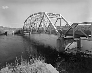
The CQA Four Mile Bridge spans the Big Horn River in Hot Springs County, Wyoming. The bridge was erected in 1927-28 by the Charles M. Smith Company and spans 175 feet (53 m) with a total length of 295 feet (90 m). The rigid 7-panel Pennsylvania through-truss was nominated for inclusion on the National Register of Historic Places as one of forty bridges throughout Wyoming that collectively illustrate steel truss construction, a technique of bridge design that has become obsolete since the mid-twentieth century. The bridge rests on concrete piers and abutments and is approached by two Warren pony trusses.

Teapot Rock, also known as Teapot Dome, is a distinctive sedimentary rock formation in Natrona County, Wyoming, notable for lending its name to a nearby oil field that became notorious as the focus of the Teapot Dome scandal, a bribery scandal during the presidential administration of Warren G. Harding. The site was listed on the National Register of Historic Places in 1974.
The Arch Creek Petroglyphs, also known as Site 48CK41 are Native American rock art figures located in Crook County, Wyoming. The site, in the southern Black Hills, is unusual in featuring comparatively long, narrow line figures incised on the rock, compared to more common V-necked anthropomorphs and shield figures. The site is particularly well preserved and is protected.
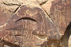
Grass Creek is an unincorporated community in Hot Springs County, Wyoming, United States. Grass Creek is 30 miles (48 km) northwest of Thermopolis. The Legend Rock Petroglyph Site, which is listed on the National Register of Historic Places, is located near Grass Creek.

The Point of Rocks Stage Station is a former resting place at the meeting point of the Overland Trail and the Union Pacific Railroad in Sweetwater County, Wyoming, USA. It was built as a stop for the Overland Stage Line in the 1861 or 1862, equidistant between the earlier Black Buttes and Salt Wells stations, which were 28 miles (45 km) apart. The station served the stage line from 1862 to 1868. In 1868, the Union Pacific line reached Point of Rocks, putting the stage line out of business. The station then became a freight depot for nearby mines, with a road leading to Atlantic City and South Pass. The freight activity declined, and in 1877, the station became a residence. At one point it was allegedly inhabited by Jim McKee, a former member of the Hole in the Wall Gang. It became the property of the state of Wyoming in 1947 and is administered as Point of Rocks Stage Station State Historic Site.

Granger Station State Historic Site, also known as Granger Stage Station, South Bend Station and Ham's Fork Station, is a state park in Granger, Wyoming, United States, that is listed on the National Register of Historic Places (NRHP).

Medicine Lodge State Archeological Site is a Wyoming state park that interprets the Medicine Lodge Creek Site, a prehistoric Native American archeological site near Hyattville, Wyoming. It is administered by the Wyoming Division of State Parks and Historic Sites. The site is at the base of a steep limestone outcropping near the point where the dry and running portions of Medicine Lodge Creek join. for a protected location with ready access to water. The site includes petroglyphs and pictographs on the rock face. Excavations starting in the 1970s have found twelve levels of habitation in 10.5 feet of stratum, ranging from historic times to 8300 years before the present. The site comprises a portion of the former Wickwire Ranch, which was purchased by the state in 1972 and became to Medicine Lodge Wildlife Habitat Management Area of 12,000 acres (4,900 ha). The archeological site was designated in 1973. The site is managed as a state park, with campgrounds and a visitor center. It was added to the National Register of Historic Places on July 5, 1973.
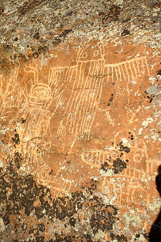
The Torrey Lake Petroglyph District extends for about 3.2 miles (5.1 km) along Torrey Creek in Fremont County, Wyoming. The site includes about 175 petroglyphs, as well as eleven lithic scatters and a sheep trap. The petroglyphs are in the Interior Line Style, or Dinwoody style, consistent with other rock art in central Wyoming. Site investigations have uncovered a number of petroglyphs that had previously been hidden under lichen. The site was placed on the National Register of Historic Places on October 4, 1993.

The Tolar Petroglyph Site is an archeological site in Sweetwater County, Wyoming. The site includes a sandstone rock formation with 32 panels of petroglyphs running for 150 feet (46 m) along the rock face. Many of the illustrations are of horse-mounted people of the Plains Indians in historical times. Other motifs include the turtle motif, spirit bear and shield-carrying warriors.