
The Arapaho are a Native American people historically living on the plains of Colorado and Wyoming. They were close allies of the Cheyenne tribe and loosely aligned with the Lakota and Dakota.

The Battle of the Washita River occurred on November 27, 1868, when Lt. Col. George Armstrong Custer's 7th U.S. Cavalry attacked Black Kettle's Southern Cheyenne camp on the Washita River.

The Bridger Mountains are a short subrange of the Rocky Mountains, approximately 40 miles (64 km) long, in central Wyoming in the United States. The range forms a bridge between the Owl Creek Mountains to the west and the southern end of the Bighorn Mountains to the east. The Wind River passes through the gap between the range and the Owl Creek Mountains. Bridger Creek passes through the gap between the range and the Bighorns. The highest point in the range is Copper Mountain at 8,300 feet (2,500 m).
The Shoshone or Shoshoni are a Native American tribe with four large cultural/linguistic divisions:

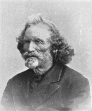
Washakie was a prominent leader of the Shoshone people during the mid-19th century. He was first mentioned in 1840 in the written record of the American fur trapper, Osborne Russell. In 1851, at the urging of trapper Jim Bridger, Washakie led a band of Shoshones to the council meetings of the Treaty of Fort Laramie. Essentially from that time until his death, he was considered the head of the Eastern Shoshones by the representatives of the United States government. In 1979, he was inducted into the Hall of Great Westerners of the National Cowboy & Western Heritage Museum.

The Battle of the Rosebud took place on June 17, 1876, in the Montana Territory between the United States Army and its Crow and Shoshoni allies against a force consisting mostly of Lakota Sioux and Northern Cheyenne Indians during the Great Sioux War of 1876. The Cheyenne called it the Battle Where the Girl Saved Her Brother because of an incident during the fight involving Buffalo Calf Road Woman. General George Crook's offensive was stymied by the Indians, led by Crazy Horse, and he awaited reinforcements before resuming the campaign in August.
The Battle of the Tongue River, sometimes referred to as the Connor Battle, was an engagement of the Powder River Expedition that occurred on August 29, 1865. In the battle, U.S. soldiers and Indian scouts attacked and destroyed an Arapaho village.
The Dull Knife Fight, or the Battle on the Red Fork, part of the Great Sioux War of 1876, was a battle that was fought on November 25, 1876, in present-day Johnson County, Wyoming between soldiers and scouts of the United States Army and warriors of the Northern Cheyenne. The battle essentially ended the Northern Cheyennes' ability to continue the fight for their freedom on the Great Plains.
Jim Baker (1818–1898), known as "Honest Jim Baker", was a frontiersman, trapper, hunter, army scout, interpreter, and rancher. He was first a trapper and hunter. The decline of the fur trade in the early 1840s drove many trappers to quit, but Baker remained in the business until 1855. During that time he was a friend of Jim Bridger, Kit Carson and John C. Frémont. On August 21, 1841, he was among a group of twenty three trappers who were attacked by Arapaho, Cheyenne, and Sioux on what became known as Battle Mountain. After Henry Fraeb was killed, Baker organized the trappers against the Native Americans in a multiple-day fight.

The Wind River Indian Reservation, in the west-central portion of the U.S. state of Wyoming, is shared by two Native American tribes, the Eastern Shoshone and the Northern Arapaho. Roughly 60 mi (97 km) east to west by 50 mi (80 km) north to south, the Indian reservation is located in the Wind River Basin, and includes portions of the Wind River Range, Owl Creek Mountains, and Absaroka Range.

The Bridger Trail, also known as the Bridger Road and Bridger Immigrant Road, was an overland route connecting the Oregon Trail to the gold fields of Montana. Gold was discovered in Virginia City, Montana in 1863, prompting settlers and prospectors to find a trail to travel from central Wyoming to Montana. In 1863, John Bozeman and John Jacobs scouted the Bozeman Trail, which was a direct route to the Montana gold fields through the Powder River Country. At the time the region was controlled by the Sioux, Cheyenne and Arapaho, who stepped up their raids in response to the stream of settlers along the trail.

Wolf Mountains Battlefield/Where Big Crow Walked Back and Forth was the site of the Battle of Wolf Mountain, the last major combat of the Great Sioux War of 1876–77. It was added to the National Register of Historic Places in 2001, and was designated a National Historic Landmark in 2008.

The Dull Knife Battlefield is located on the eastern slope of the Bighorn Mountains in Johnson County, Wyoming near Kaycee. It was the scene of the Dull Knife Fight on November 25, 1876, in which the Fourth Cavalry under General Ranald S. Mackenzie raided the winter encampment of the NorthernCheyenne, destroying most of their material culture and all their winter supplies and thus forcing the Northern Cheyenne to seek shelter with the village of Crazy Horse in order to survive the winter. Five hundred ponies were captured and about 173 lodges destroyed. The Dull Knife battlefield is on private land and is available to visit only by special arrangement. The fight took place on November 25, 1876.

Pawnee Scouts were employed by the United States Army in the latter half of the 19th century. Like other groups of Indian scouts, Pawnee men were recruited in large numbers to aid in the ongoing conflicts between settlers and the Native Americans in the United States. Because the Pawnee people were at war with the Sioux and Cheyenne and had been under constant pressure and aggression by those tribes, some of them were more than willing to serve with the army for pay. A number of Pawnee served between 1864 and 1871. They were armed with rifles, revolvers and were issued scout uniforms.

Half Yellow Face was the leader of the six Crow Scouts for George Armstrong Custer's 7th Cavalry during the 1876 campaign against the Sioux and Northern Cheyenne. Half Yellow Face led the six Crow scouts as Custer advanced up the Rosebud valley and crossed the divide to the Little Bighorn valley, and then as Custer made the fateful decision to attack the large Sioux-Cheyenne camp which precipitated the Battle of the Little Bighorn on June 25, 1876. At this time, the other Crow Scouts witnessed a conversation between Custer and Half Yellow Face. Half Yellow Face made a statement to Custer that was poetically prophetic, at least for Custer: "You and I are going home today by a road we do not know".

St. Michael's Mission is an Episcopal church mission established about 1887 in Fremont County, Wyoming to minister to the Arapaho and Shoshone of the Wind River Indian Reservation. It was founded by Reverend John Roberts with the permission of Shoshone Chief Washakie. The community of Ethete grew around the mission, given its name by Washakie's assent in the Shoshone language, ethete. In 1900 a small log church was built about 3 miles (4.8 km) from the present location. In 1910 the mission received an endowment from Mrs. Baird Cooper and the new site was developed over the next seven years. In 1920 the original church was moved to the mission, enlarged, and named "The Church of Our Father's House.
The Wind River Agency Blockhouse, also known as the Trout Creek Blockhouse, was built in 1871 on the Wind River Indian Reservation. It is one of the oldest surviving structures in Wyoming. The blockhouse was built at the suggestion of Chief Washakie as a defensive position for the local Shoshone and non-Indians against attack by Cheyenne, Northern Arapaho and Sioux raiders. After the Wyoming Territory became more stable the structure served as a jail and as a storehouse.

Wo’óoseinee’, known commonly as Black Coal, (c.1840-1893) was a prominent leader of the Northern Arapaho people during the latter half of the 19th Century. Serving as an intermediary between the Northern Arapaho and the United States, he helped lead the transition from free-roaming life and armed resistance to American expansion, to alliance and eventual settlement alongside the Eastern Shoshone at today's Wind River Indian Reservation.
Black Bear was an Arapaho leader into the 1860s when the Northern Arapaho, like other Native American tribes, were prevented from ranging through their traditional hunting grounds due to settlement by European-Americans who came west during the Pike's Peak Gold Rush. Conflicts erupted over land and trails used by settlers and miners. A watershed event was the Sand Creek massacre of 1864. This led to the Northern Arapaho joining with other tribes to prevent settlement in their traditional lands. In 1865, Black Bear's village was attacked during the Battle of the Tongue River. People died, lodges were set on fire, and food was ruined, all of which made it difficult for them to survive as a unit. He died during an ambush by white settlers on April 8, 1870, in the Wild Wind Valley of present-day Wyoming.

Friday (Arapaho: Teenokuhu or Warshinun, also known as Friday Fitzpatrick, was an Arapaho leader and interpreter in the mid to late 1800s. When he was around the age of eight, he was separated from his band and was taken in by a white trapper. During the next seven years, he was schooled in St. Louis, Missouri and went on trapping expeditions with his informally adopted father, Thomas Fitzpatrick. After he was recognized by his mother during an encounter with the Arapaho, he returned to the tribe.

