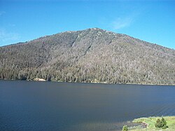
Hebgen Lake

Last updated
Hebgen Lake
Hebgen Lake by Sentinel-2.jpg
Hebgen Lake
Location Gallatin County, Montana,
United States
Coordinates 44°51′50″N111°20′07″W / 44.86389°N 111.33528°W / 44.86389; -111.33528 Coordinates: 44°51′50″N111°20′07″W / 44.86389°N 111.33528°W / 44.86389; -111.33528
Primary inflows Madison River
Catchment area 905 square miles (2,340 km2)
Basin  countriesUnited States
Max. length15 miles (24 km)
Max. width4 miles (6.4 km)
Surface area21 square miles (54 km2)
Water volume524,333,333 cubic yards (400,881,597 m3) [1]
Shore length165 miles (105 km)
1 Shore length is not a well-defined measure.

Hebgen Lake is located in Southwest Montana and is created by Hebgen Dam. It is well known for the 1959 Hebgen Lake earthquake (magnitude 7.1 to 7.5) which occurred nearby on August 17, 1959, forming Quake Lake, which is located immediately downstream.

Contents

Recreation

Hebgen Lake and the surrounding area offer many recreational activities: camping, fishing, boating, and hiking. Campgrounds include Rainbow Point and Cherry Creek. Rainbow Point is the largest campground on the lake, offering four "loops." Each loop contains approximately 20 campsites. Each campsite can accommodate a full-size camper and one or two vehicles.

See also

Images

Related Research Articles

Yellowstone National Park First national park in the world, located in the US states of Wyoming, Montana and Idaho

Yellowstone National Park is an American national park located mostly in Wyoming, with small sections in Montana and Idaho. It was established by the U.S. Congress and signed into law by President Ulysses S. Grant on March 1, 1872. Yellowstone was the first national park in the U.S. and is also widely held to be the first national park in the world. The park is known for its wildlife and its many geothermal features, especially Old Faithful geyser, one of its most popular features. It has many types of ecosystem, but the subalpine forest is the most abundant. It is part of the South Central Rockies forests ecoregion.

Madison River river in Montana and Wyoming, United States

The Madison River is a headwater tributary of the Missouri River, approximately 183 miles (295 km) long, in Wyoming and Montana. Its confluence with the Jefferson and Gallatin rivers near Three Forks, Montana forms the Missouri River.

Folsom Lake State Recreation Area

The Folsom Lake State Recreation Area surrounds Folsom Lake in the foothills of the Sierra Nevada, and is managed by the California Department of Parks and Recreation. It is located near the city of Folsom, California, about 25 miles (40 km) east of Sacramento.

Curecanti National Recreation Area

Curecanti National Recreation Area is a National Park Service unit located on the Gunnison River in western Colorado. Established in 1965, Curecanti is responsible for developing and managing recreational facilities on three reservoirs, Blue Mesa Reservoir, Morrow Point Reservoir and Crystal Reservoir, constructed on the upper Gunnison River in the 1960s by the U.S. Bureau of Reclamation to better utilize the vital waters of the Colorado River and its major tributaries. A popular destination for boating and fishing, Curecanti offers visitors two marinas, traditional and group campgrounds, hiking trails, boat launches, and boat-in campsites. The state's premiere lake trout and Kokanee salmon fisheries, Curecanti is a popular destination for boating and fishing, and is also a popular area for ice-fishing in the winter months.

Gallatin National Forest U.S. national forest in Montana

Founded in 1899, Gallatin National Forest is located in south central Montana, United States. The forest comprises 1,819,515 acres (7,363.32 km2) and has portions of both the Absaroka-Beartooth and Lee Metcalf Wilderness areas within its boundaries. Gallatin National Forest borders Yellowstone National Park on the north and northwest and is part of the Greater Yellowstone Ecosystem, a region which encompasses almost 20,000,000 acres (81,000 km2). The forest is named after Albert Gallatin (1761–1849), U.S. Secretary of the Treasury and scholar of Native American languages and cultures.

Quake Lake Lake in Madison County, Montana

Quake Lake is a lake in southwestern Montana in the United States. It was created after an earthquake struck on August 17, 1959, killing 28 people. Today, Quake Lake is 190 feet (58 m) deep and 6 miles (9.7 km) long. US 287 follows the lake and offers glimpses of the effects of the earthquake and landslide, and a visitor center is just off the road. The lake is mostly within Gallatin National Forest.

Hebgen Dam dam in Gallatin County, Montana

The Hebgen Dam is a concrete-core earthen embankment dam on the Madison River in the U.S. state of Montana. The dam is 85 feet tall and 721 feet long. The dam's purpose is to store and regulate water for other downstream reservoirs and hydroelectric power plants. Montana Power Company originally built the dam, PPL Corporation purchased it in 1997 and sold it to NorthWestern Corporation in 2014.

Golden Ears Provincial Park provincial park

Golden Ears Provincial Park is a Provincial Park in British Columbia, Canada and is 555.9 square kilometres (214.6 sq mi). It is named after the prominent twin peaks which are commonly referred to as Golden Ears. The park's southern end is located on the northern edge of the district municipality of Maple Ridge on the north side of the Fraser River.

Kikomun Creek Provincial Park provincial park in British Columbia

Kikomun Creek Provincial Park is a provincial park in British Columbia, Canada.

Lynx Lake (Arizona) lake of the United States of America

Lynx Lake, Arizona, is a 55-acre (220,000 m2) reservoir located within Prescott National Forest, approximately 5 miles (8.0 km) east of Prescott, Arizona, in the Bradshaw Mountains. The lake is located at 5,530 feet (1,690 m) elevation and is stocked for fishing. It is one of the most popular recreation areas in central Arizona. Mild weather, the cool ponderosa pine forest, trout fishing, boating, mountain hiking, horseback riding, archaeological sites, and bird watching attract visitors from throughout Arizona. The lake was formed in 1952, when a dam was put in Lynx Creek, 6 miles (9.7 km) below Walker, Arizona.

Crane Flat Campground campground in California

Crane Flat Campground, elevation 6,200 feet (1,900 m), is located in Yosemite National Park, 17 miles (27 km) northwest of Yosemite Valley. Of all campgrounds outside of Yosemite Valley, Crane Flat is the closest to the Valley in terms of mileage and travel time. The campground is directly off the road. Each campsite contains a fire ring, picnic table, and food locker, and is near a bathroom with potable water and flushing toilets.

Bridalveil Creek Campground campground in California

Bridalveil Creek Campground, located in southern area of Yosemite National Park along Glacier Point road, is a first-come first-served campground outside of Yosemite Valley. The campground is directly off the road and thus does not require a rough drive to the campground like other Yosemite campgrounds outside of the Valley. Bridalveil Creek Campground contains 110 campsites and is in the high-country at 7,000 feet (2,100 m). It is fairly isolated and quiet. This campground is especially good considering its proximity to Glacier Point. Given the convenience one can more easily drive to Glacier Point at night to survey the night sky. The Valley is quite far from Bridalveil Creek and those looking to venture into northern regions of Yosemite National Park should expect a long drive.

Lyman Run State Park

Lyman Run State Park is a 595-acre (241 ha) Pennsylvania state park in Ulysses and West Branch Townships in Potter County, Pennsylvania in the United States. Lyman Run Lake is a 45-acre (18 ha) man-made lake within the park, surrounded by a northern hardwood forest of mainly maple and cherry trees. Lyman Run State Park is 7 miles (11 km) west of Galeton and 15 miles (24 km) east of Coudersport, and is nearly completely surrounded by the Susquehannock State Forest.

1959 Hebgen Lake earthquake

The 1959 Hebgen Lake earthquake occurred on August 17 at 11:37 pm (MST) in southwestern Montana, United States. The earthquake measured 7.2 on the Moment magnitude scale, caused a huge landslide, resulted in over 28 fatalities and left US$11 million in damage. The slide blocked the flow of the Madison River, resulting in the creation of Quake Lake. Significant effects of the earthquake were also felt in nearby Idaho and Wyoming, and lesser effects as far away as Puerto Rico and Hawaii.

Madison Range mountain range located in the Rocky Mountains of Montana and Idaho, U.S.

The Madison Range is a mountain range located in the Rocky Mountains of Montana and Idaho in the United States. The range was named in honor of future President of the United States, then U.S. Secretary of State James Madison by Meriwether Lewis as the Lewis and Clark Expedition travelled through Montana in 1805. The range extends 80 miles (130 km) from West Yellowstone, Montana to Bozeman, Montana and is flanked by the Madison River on the west and the Gallatin River to the east. The highest point in the range is Hilgard Peak at 11,316 ft (3,449 m), a remote peak that wasn't climbed until 1948.

1983 Borah Peak earthquake

The 1983 Borah Peak earthquake occurred on Friday, October 28, at 8:06:09 a.m. MDT in the western United States, in the Lost River Range at Borah Peak in Central Idaho.

Henrys Lake Mountains mountain range in Idaho and Montana

The Henrys Lake Mountains, highest point Sheep Point, el. 10,609 feet (3,234 m), are a small mountain range northwest of West Yellowstone, Montana in Madison County, Montana. These mountains are also referred to as the Lionhead Mountains, and straddle the Continental Divide along the Idaho-Montana border. On the northwest corner of these mountains is Quake Lake, created when the 1959 Hebgen Lake earthquake caused a massive landslide and dammed the Madison River. Nine subalpine lakes sit in high cirques in the higher reaches, with several peaks topping 10,000'. Coffin Lake is the largest and most popular, on the Montana side. About 32,000 acres are roadless in the Montana portion, with an unknown amount in Idaho. Dense forests, pristine streams, rolling tundra, and grassy parks provide year-round habitat for grizzly bears, elk, and bighorn sheep. Rocks and soils are inherently unstable, a factor in the landslide that caused much loss of life in 1959. The instability exists because the range is basically limestone blocks sitting on top of shale and Yellowstone volcanic rocks.

Davis Lake lake in Deschutes County, United States of America

Davis Lake straddles the border between Deschutes County and Klamath County in the U.S. state of Oregon. A relatively large and shallow lake in the Deschutes National Forest, it is located toward the south end of the Cascade Lakes Scenic Byway, near Oregon Route 58 and U.S. 97. The lake is known as one of Oregon's best bass lakes.

Lonesomehurst Cabin United States historic place

Lonesomehurst Cabin is a log cabin style recreational residence on the west side of the South Fork Arm of Hebgen Lake near West Yellowstone, in Gallatin County, Montana. Hebgen Lake is on the Madison River. There are three buildings on the site: a wood frame cabin constructed circa 1919, a log boathouse built in 1958, and a wood frame outhouse built about 1930. The cabin is at the south end of the site, which is 8 miles (13 km) west of West Yellowstone and the entrance to Yellowstone National Park.

Morning Geyser geyser in Yellowstone National Park

Morning Geyser is a fountain-type geyser located in the Fountain Paint Pots area of Lower Geyser Basin of Yellowstone National Park, Wyoming. When active it is the largest geyser in the Fountain Paint Pots area, but in most years it is inactive.

References

  1. "HEBGEN LAKE IS 65 MILES AROUND". Montana Standard. 19 August 1959. Archived from the original on 8 March 2012. Retrieved 11 July 2010.