Columbia Falls, Montana

Last updated

Columbia Falls
Flathead River.jpg
View of the Flathead River from River's Edge Park.
Flathead County Montana Incorporated and Unincorporated areas Columbia Falls Highlighted.svg
Location of Columbia Falls, Montana
Coordinates: 48°22′13″N114°11′20″W / 48.37028°N 114.18889°W / 48.37028; -114.18889
CountryFlag of the United States.svg  United States
State Flag of Montana.svg  Montana
County Flathead
Government
  MayorDonald Barnhart
  City ManagerSusan Nicosia
Area
[1]
  Total2.25 sq mi (5.82 km2)
  Land2.24 sq mi (5.81 km2)
  Water0.00 sq mi (0.01 km2)
Elevation
[2]
3,081 ft (939 m)
Population
 (2020)
  Total5,308
  Density2,366.47/sq mi (913.55/km2)
Time zone UTC−7 (Mountain (MST))
  Summer (DST) UTC−6 (MDT)
ZIP code
59912
Area code 406
FIPS code 30-16600
GNIS feature ID0806934 [2]
Website City website

Columbia Falls is a city along the Flathead River in Flathead County, Montana, United States. The population was 5,308 at the 2020 census. [3] Columbia Falls has been ranked as one of the best and safest places to live in Montana. [4] [5] [6]

Contents

History

The area that would become the city of Columbia Falls was first settled in 1891, in anticipation of the arrival of the Great Northern Railway. [7] On April 26, 1909, the city of Columbia Falls was officially incorporated. [8]

The first residents requested the name "Columbia" for the U.S. Post Office, but the element "Falls" was ultimately tacked onto the name in order to avoid any confusion with the already-named Columbus, Montana. [9]

The Montana Veterans Home in Columbia Falls has served veterans since 1896. [10] Its current housing facility was opened by Montana Governor Forrest H. Anderson at an official dedication ceremony in 1970. [11] An E. M. Viquesney statue of a World War I doughboy was moved to the front of the Veterans' Home in 1972. The statue "originally stood in Kalispell in the Main Street median in front of the Flathead County Courthouse." [12]

Geography

The City of Columbia Falls is located about a mile from the Flathead National Forest boundary, 15 miles from Kalispell and 17 miles from Glacier National Park. [13] [14]

According to the United States Census Bureau, the city has a total area of 2.05 square miles (5.31 km2), all land. [15]

Demographics

Historical population
CensusPop.Note
1910 601
1920 6111.7%
1930 6374.3%
1940 6370.0%
1950 1,23293.4%
1960 2,13273.1%
1970 2,65224.4%
1980 3,11217.3%
1990 2,942−5.5%
2000 3,64523.9%
2010 4,68828.6%
2020 5,30813.2%
U.S. Decennial Census [16] [3]

2010 census

At the 2010 census there were 4,688 people, 1,863 households, and 1,215 families living in the city. The population density was 2,286.8 inhabitants per square mile (882.9/km2). There were 1,994 housing units at an average density of 972.7 per square mile (375.6/km2). The racial makup of the city was 94.4% White, 0.2% African American, 1.8% Native American, 0.4% Asian, 0.3% from other races, and 2.9% from two or more races. Hispanic or Latino of any race were 2.8%. [17]

Of the 1,863 households 35.0% had children under the age of 18 living with them, 47.9% were married couples living together, 12.9% had a female householder with no husband present, 4.5% had a male householder with no wife present, and 34.8% were non-families. 28.8% of households were one person and 11% were one person aged 65 or older. The average household size was 2.47 and the average family size was 3.02.

The median age was 35.6 years. 26% of residents were under the age of 18; 8.5% were between the ages of 18 and 24; 26.8% were from 25 to 44; 25.3% were from 45 to 64; and 13.2% were 65 or older. The gender makeup of the city was 48.1% male and 51.9% female.

2000 census

At the 2000 census there were 3,645 people, 1,400 households, and 966 families living in the city. The population density was 2,402.9 inhabitants per square mile (927.8/km2). There were 1,470 housing units at an average density of 969.1 per square mile (374.2/km2). The racial makeup of the city was 96.27% White, 0.25% African American, 1.23% Native American, 0.49% Asian, 0.08% Pacific Islander, 0.41% from other races, and 1.26% from two or more races. Hispanic or Latino of any race were 1.84%. [18]

Of the 1,400 households 36.3% had children under the age of 18 living with them, 52.0% were married couples living together, 12.1% had a female householder with no husband present, and 31.0% were non-families. 25.7% of households were one person and 11.0% were one person aged 65 or older. The average household size was 2.52 and the average family size was 3.06.

The age distribution was 28.3% under the age of 18, 8.1% from 18 to 24, 28.6% from 25 to 44, 21.5% from 45 to 64, and 13.4% 65 or older. The median age was 36 years. For every 100 females there were 99.2 males. For every 100 females age 18 and over, there were 97.4 males.

The median household income was $31,128 and the median family income was $40,794. Males had a median income of $32,109 versus $20,023 for females. The per capita income for the city was $14,355. About 12.5% of families and 17.1% of the population were below the poverty line, including 25.8% of those under age 18 and 4.0% of those age 65 or over.

Arts and culture

St. Richard's Church in Columbia Falls ST. RICHARD'S CHURCH, COLUMBIA FALLS, FLATHEAD COUNTY.jpg
St. Richard's Church in Columbia Falls

Heritage Days is an annual celebration of the town's history and heritage. It occurs on the last weekend of July. Activities include Boogie to the Bank, Wildcat Endowment Auction, a parade and carnival, basketball tournament, a barn dance, car show, rodeo, and the running of wild horses through town on Highway 2. [19]

Night of Lights Parade is an annual December holiday parade. [20]

Columbia Falls has a public library, a branch of the Flathead County Library. [21]

Columbia Falls Community Market is a farmers market held weekly every Thursday from 5pm - 8pm from the second Thursday in May until the last Thursday in September. [22] [23] The market offers live music, food trucks, local produce, locally brewed beer and a rock-climbing wall. [23] [24] [25]

Parks and recreation
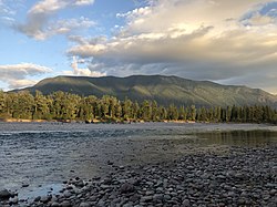
River's Edge Park has over 900 ft (270 m) of river frontage on Flathead River and occupies 28 acres (11 ha). The park has paved walking trails, open meadows, bathroom facilities and a family fly fishing pond. [26]

Pinewood Park Aquatic Center is a public swimming facility located on 4th Ave West. The park also has a basketball court, children's play area, picnic tables and swings. [27]

Government

The government system of Columbia Falls consists of a City Council with six councilmen and a mayor, elected to four-year terms. [28]

In June 2020, Columbia Falls voters elected to implement a 3% resort tax on all luxury items and services within city limits, more than 50% of the tax revenue is slated to go toward public safety funding. [29] [30]

Education

Schools in Columbia Falls School District Six include Columbia Falls High School, Columbia Falls Junior High School, Glacier Gateway Elementary School, and Ruder Elementary School. School District Six has a approximately 2,400 students. [31] In 2019 voters approved a $37 million school bond which will fund a new Glacier Gateway Elementary School, a 25,000 square foot addition to the Ruder Elementary School, a security upgrade for the Junior High School and new multi-use sports fields. [32] [33]

Columbia Falls High School's mascot is the Wildcats. [34]

The area is served by the ImagineIF library, which also has branches in Bigfork, Kalispell, and Marion. [35]

Transportation

U.S. Highway 2 runs through Columbia Falls. The North Fork Road (S-486) begins at the junction to U.S. Highway 2 in Columbia Falls and runs to the Canadian border. [36]

Commercial airline service is offered at Glacier Park International Airport located approximately 8 miles south of Columbia Falls. [37] [38]

The Columbia Falls area is served by Amtrak's Chicago-Portland/Seattle Empire Builder , with stops located nearby in Whitefish and West Glacier. [39]

Media

Columbia Falls is served by Hungry Horse News. [40] The city is also part of the Missoula media market, which covers a seven-county area of northwestern Montana.

KHNK 95.9 FM, (Outlaw Country) and KRVO 103.1 FM are commercial radio stations located in Columbia Falls, broadcasting to the Kalispell-Flathead Valley, Montana, area. KHNK airs a country music format and KRVO airs an adult alternative format. [41] [42]

Notable people

Points of interest

See also

Related Research Articles

<span class="mw-page-title-main">Lincoln County, Montana</span> County in Montana, United States

Lincoln County is a county located in the U.S. state of Montana. As of the 2020 census, the population was 19,677. Its county seat is Libby. The county was founded in 1909 and named for President Abraham Lincoln. The county lies on Montana's north border and thus shares the US-Canadian border with the Canadian province of British Columbia.

<span class="mw-page-title-main">Flathead County, Montana</span> County in Montana, United States

Flathead County is in the U.S. state of Montana. At the 2020 census, its population was 104,357, making it the state's fourth most populous county. Its county seat is Kalispell. Its numerical designation is 7. Its northern border is on the state's north border, making it contiguous with the Canada–US border, facing British Columbia.

<span class="mw-page-title-main">Bigfork, Montana</span> Unincorporated community in Montana, United States

Bigfork is a census-designated place (CDP) in Flathead County, Montana, United States. It is within Montana's Rocky Mountains. The population was 5,118 at the 2020 census, up from 4,270 in 2010.

<span class="mw-page-title-main">Coram, Montana</span> Unincorporated community in Montana, United States

Coram is an unincorporated community and census-designated place (CDP) in Flathead County, Montana, United States. The population was 539 in 2010, up from 337 at the 2000 census. Coram lies 7 miles (11 km) southwest of the western entrance of Glacier National Park.

<span class="mw-page-title-main">Evergreen, Montana</span> Unincorporated community in Montana, United States

Evergreen is a census-designated place (CDP) in Flathead County, Montana, United States. Its population was 8,149 at the 2020 census, up from 7,616 at the 2010 census, and 6,215 in 2000.

<span class="mw-page-title-main">Hungry Horse, Montana</span> Unincorporated community in Montana, United States

Hungry Horse is an unincorporated community and census-designated place (CDP) in Flathead County, Montana, United States. The population was 828 at the 2020 census. The ZIP code for Hungry Horse is 59919.

<span class="mw-page-title-main">Kalispell, Montana</span> City in Montana, United States

Kalispell is a city in Montana and the county seat of Flathead County, Montana, United States. The 2020 census put Kalispell's population at 24,558. In Montana's northwest region, it is the largest city and the commercial center of the Kalispell Micropolitan Statistical Area. The name Kalispell is a Salish word meaning "flat land above the lake".

<span class="mw-page-title-main">Lakeside, Montana</span> Unincorporated community in Montana, United States

Lakeside is an unincorporated area and census-designated place (CDP) in Flathead County, Montana, United States. The population was 2,705 at the 2020 census, up from 2,669 in 2010.

<span class="mw-page-title-main">Martin City, Montana</span> Unincorporated community in Montana, United States

Martin City is an unincorporated community and census-designated place (CDP) in Flathead County, Montana, United States. As of the 2010 census, it had a population of 500, up from 331 in 2000.

<span class="mw-page-title-main">Somers, Montana</span> Unincorporated community in Montana, United States

Somers is an unincorporated community and census-designated place (CDP) in Flathead County, Montana, United States. The population was 1,049 at the 2020 census, nearly double from 556 in the 2000 census.

<span class="mw-page-title-main">Whitefish, Montana</span> City in Montana, United States

Whitefish is a city in Flathead County, Montana, United States. According to the 2020 United States Census, there were 7,751 people in the city.

<span class="mw-page-title-main">East Glacier Park Village, Montana</span> CDP in Montana, United States

East Glacier Park is an unincorporated community and census-designated place (CDP) in Glacier County, Montana, United States. As of the 2020 census, it had a population of 354.

<span class="mw-page-title-main">Elmo, Montana</span> Census-designated place in Montana, United States

Elmo is a census-designated place (CDP) in Lake County, Montana, United States. The population was 180 at the 2010 census, up from 143 in 2000.

<span class="mw-page-title-main">Polson, Montana</span> Town in Montana, United States

Polson is a city in Lake County, Montana, United States, on the southern shore of Flathead Lake. It is also on the Flathead Indian Reservation. The population was 5,148 at the 2020 census. It is the county seat of Lake County. In 1898 the city was named after pioneer rancher David Polson. It was incorporated in 1910.

<span class="mw-page-title-main">Ronan, Montana</span> City in Montana, United States

Ronan is a city in Lake County, Montana, United States. It is on the Flathead Indian Reservation. The population was 1,955 at the 2020 census.

<span class="mw-page-title-main">Eureka, Montana</span> Town in Montana, United States

Eureka is a town in Lincoln County, Montana, United States, 9 miles (14 km) south of the Canada–US border. The population was 1,380 at the 2020 census.

<span class="mw-page-title-main">Libby, Montana</span> City in Montana, United States

Libby is a city in northwestern Montana, United States and the county seat of Lincoln County. The population was 2,775 at the 2020 census.

<span class="mw-page-title-main">Flathead River</span> River in Montana, United States

The Flathead River, in the northwestern part of the U.S. state of Montana, originates in the Canadian Rockies to the north of Glacier National Park and flows southwest into Flathead Lake, then after a journey of 158 miles (254 km), empties into the Clark Fork. The river is part of the Columbia River drainage basin, as the Clark Fork is a tributary of the Pend Oreille River, a Columbia River tributary. With a drainage basin extending over 8,795 square miles (22,780 km2) and an average discharge of 11,380 cubic feet per second (322 m3/s), the Flathead is the largest tributary of the Clark Fork and constitutes over half of its flow.

<span class="mw-page-title-main">Soldiers' Home Historic District</span> Historic district in Montana, United States

The Soldiers' Home Historic District, a historic Old soldiers' home campus, is located in Columbia Falls, Flathead County, Montana.

References

  1. "ArcGIS REST Services Directory". United States Census Bureau. Retrieved September 5, 2022.
  2. 1 2 U.S. Geological Survey Geographic Names Information System: Columbia Falls, Montana
  3. 1 2 "U.S. Census website". United States Census Bureau . Retrieved November 2, 2021.
  4. Flynn, Liz (October 6, 2019). "The 20 Best Places to Live in Montana". Money Inc. Retrieved November 27, 2020.
  5. "Montana's 10 Safest Cities of 2020". SafeWise. July 1, 2020. Retrieved November 27, 2020.
  6. "The 10 Safest Cities In Montana For 2020". HomeSnacks. Retrieved November 27, 2020.
  7. "Columbia Falls History". Archived from the original on December 14, 2021.
  8. "Columbia Falls Heritage Days "Official" Website - History". cfallsheritagedays.com. Retrieved December 14, 2021.
  9. "YESTERDAYS: THE REAL STORY BEHIND THE NAME, 'COLUMBIA FALLS'". Hungry Horse News. Retrieved July 4, 2019.
  10. "Montana Veterans' Home - Columbia Falls". Montana Department of Public Health & Human Services - Senior & Long Term Care. Retrieved February 6, 2014.
  11. Montana Veterans Home (1970). History and future of Montana Veterans' Home, Columbia Falls, Montana. Columbia Falls, MT. Retrieved February 6, 2014.{{cite book}}: CS1 maint: location missing publisher (link)
  12. "Columbia Falls, Montana Viquesney Doughboy Statue". The E. M. Viquesney Doughboy Database. Retrieved February 6, 2014.
  13. "Community Profile". City of Columbia Falls Montana. Retrieved December 6, 2020.
  14. "Columbia Falls to Flathead NF distance".
  15. "US Gazetteer files 2010". United States Census Bureau. Archived from the original on July 2, 2012. Retrieved December 18, 2012.
  16. United States Census Bureau. "Census of Population and Housing" . Retrieved July 14, 2016.
  17. "U.S. Census website". United States Census Bureau . Retrieved December 18, 2012.
  18. "U.S. Census website". United States Census Bureau . Retrieved January 31, 2008.
  19. "Heritage Days".
  20. "Night of Lights 2018". Columbia Falls Area Chamber of Commerce. Retrieved November 26, 2020.
  21. "Montana Public Libraries". PublicLibraries.com. Retrieved June 14, 2019.
  22. "Columbia Falls Community Market". Columbia Falls Area Chamber of Commerce. Retrieved December 4, 2020.
  23. 1 2 "The Market". web1. Retrieved December 4, 2020.
  24. PETERSON, CHRIS (June 17, 2020). "Community Market sees leadership change". Hungry Horse News. Retrieved December 4, 2020.
  25. Perez, Vanessa (May 14, 2020). "Columbia Falls Community Market opens for season". KECI. Retrieved December 4, 2020.
  26. "River's Edge Park". City of Columbia Falls Montana. Retrieved November 26, 2020.
  27. "Pinewood Park Aquatic Center". City of Columbia Falls Montana. Retrieved December 4, 2020.
  28. "Mayor & City Council". City of Columbia Falls Montana. Retrieved November 26, 2020.
  29. "Columbia Falls Resort Tax Takes Effect". Flathead Beacon. October 15, 2021. Retrieved December 14, 2021.
  30. PETERSON, CHRIS (September 30, 2021). "Columbia Falls resort tax goes into effect Oct. 1". Daily Inter Lake. Retrieved December 14, 2021.
  31. "Columbia Falls School District 6 – Home of the Wildcats" . Retrieved January 7, 2021.
  32. "Columbia Falls School Bond Projects Moving Forward". Flathead Beacon. June 9, 2020. Retrieved January 7, 2021.
  33. "Columbia Falls Voters Approve $37 Million School Bond". Flathead Beacon. October 9, 2019. Retrieved January 7, 2021.
  34. "Member Schools". Montana High School Association. Retrieved April 19, 2021.
  35. "Locations and Hours". ImagineIF Libraries. Retrieved April 13, 2021.
  36. "North Fork Road Study". Archived from the original on May 9, 2010.
  37. "Driving Distance from FCA to Columbia Falls, MT". www.travelmath.com. Retrieved January 7, 2021.
  38. "Glacier Park International Airport". Columbia Falls Area Chamber of Commerce. Retrieved January 7, 2021.
  39. "Airport & Amtrak make Columbia Falls and Glacier Park Accessible". Columbia Falls Area Chamber of Commerce. Retrieved January 7, 2021.
  40. "Hungry Horse News". hungryhorsenews.com. Retrieved November 26, 2020.
  41. "95.9 Outlaw Country". 95.9 Outlaw Country. Retrieved November 26, 2020.
  42. "KRVO The River 103.1 FM Columbia Falls MT USA". StreamingTheNet. Retrieved January 7, 2021.
  43. Mark Brunson (April 13, 1984). "Reagan's future son-in-law originally from Martin City". Daily Inter Lake (Kalispell, Montana). Retrieved March 20, 2021.
  44. "Anthony M. Kurta > U.S. DEPARTMENT OF DEFENSE > Biography". www.defense.gov. Retrieved January 21, 2021.
  45. "Matt Regier - Montana Environmental Information Center - MEIC". meic.org. Retrieved November 28, 2020.
  46. "Glenn Roush Obituary (1934 - 2020) - Great Falls Tribune". www.legacy.com. Retrieved January 21, 2021.
  47. "Mel Ruder: Montana's first Pulitzer winner, dies at 85". Helena Independent Record. November 20, 2000. Retrieved November 27, 2020.
  48. "Gloria Jean Siebrecht". Golden Triangle News. December 8, 2021. Retrieved January 22, 2023.
  49. "NPGallery Asset Detail". npgallery.nps.gov. Retrieved January 7, 2021.
  50. Military.com, 31 Jul 2020 (July 31, 2020). "Montana State Veteran Benefits". Military.com. Retrieved January 7, 2021.{{cite web}}: CS1 maint: numeric names: authors list (link)