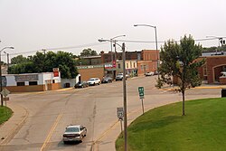
Wolf Point, Montana

Last updated

Wolf Point
Montana Highway 25 Wolf Point MT.jpg
Downtown Wolf Point
Roosevelt County Montana Incorporated and Unincorporated areas Wolf Point Highlighted.svg
Location of Wolf Point, Montana
Coordinates: 48°5′29″N105°38′33″W / 48.09139°N 105.64250°W / 48.09139; -105.64250
Country United States
State Montana
County Roosevelt
Incorporated (city)1915
Government
  Type Tribal
  MayorChristopher M. Dschaak
Area
[1]
  Total0.88 sq mi (2.29 km2)
  Land0.88 sq mi (2.29 km2)
  Water0.00 sq mi (0.00 km2)
Elevation
2,000 ft (609 m)
Population
 (2020)
  Total2,517
  Density2,850.51/sq mi (1,100.95/km2)
Time zone UTC−7 (Mountain Standard Time (MST))
  Summer (DST) UTC−6 (Mountain Daylight Time (MDT))
ZIP code
59201
Area code 406
FIPS code 30-81475
GNIS feature ID0778652
Website http://ci.wolf-point.mt.us/

Wolf Point is a city in and the county seat of Roosevelt County, Montana, United States. [2] The population was 2,517 at the 2020 census, down 4% from 2,621 in the 2010 Census. [3] It is the largest community on the Fort Peck Indian Reservation. Wolf Point is the home of the annual Wild Horse Stampede, held every year during the second weekend of July. Wolf Point's Wild Horse Stampede is the oldest rodeo in Montana, and has been called the "Grandaddy of Montana Rodeos". [4] [5] [6]

Contents

Wolf Point also is home of the Wadopana Pow-wow, the oldest traditional pow wow in Montana and always held the first week in August. [7]

History

Wolf Point began as a trading post in the 1860s, at the confluence of Wolf Creek and the Missouri River. Farming began in the area as early as 1874. The Great Northern Railway arrived in 1887. [8] Wolf Point incorporated in 1915 and became the county seat in 1919.

Geography

Street in Wolf Point, 1941. Photo by Marion Post Wolcott. Street in Wolf Point Montana (1941).jpg
Street in Wolf Point, 1941. Photo by Marion Post Wolcott.

Topography

Wolf Point is located in north-eastern Montana in the wide, shallow valley of the Missouri River, just below its confluence with Wolf Creek. Wolf Point is situated on the High Plains of eastern Montana. According to the United States Census Bureau, the city has a total area of 0.88 square miles (2.28 km2), all land. [9]

The city is located on the north bank of the Missouri River, the southern part occupying the ancestral floodplain of that river. The northern part occupies south facing, low-lying hills overlooking a terrace. [10] The central business district is located in the described southern portion.

Climate

Wolf Point experiences a semi-arid steppe climate (BSkw) , [11] with generally cold, dry winters and hot summers. Late spring and early summer is on average the wettest period of the year. During the summer warm, humid air masses more typical of a warm summer continental climate (Dfb) may move into the area from the south or east. Summertime thunderstorms commonly occur and sometimes can be severe featuring hail and, infrequently, funnel clouds or tornados.

Cold waves may cover the area 6 to 12 times per winter, with temperatures well below 0 °F (−17.8 °C). Between cold waves there are sometimes periods of longer than 10 days of mild, but often windy weather caused by chinook winds. [12] These winds cause temperatures to rise rapidly, often giving relief in the form of mild temperatures in the coldest months of the year.

Climate data for Wolf Point, Montana (1991–2020 normals, extremes 1974–present)
MonthJanFebMarAprMayJunJulAugSepOctNovDecYear
Record high °F (°C)59
(15)
71
(22)
80
(27)
95
(35)
102
(39)
112
(44)
107
(42)
109
(43)
105
(41)
93
(34)
75
(24)
65
(18)
112
(44)
Mean daily maximum °F (°C)25.4
(−3.7)
31.1
(−0.5)
44.9
(7.2)
59.6
(15.3)
69.7
(20.9)
77.9
(25.5)
86.9
(30.5)
86.4
(30.2)
75.5
(24.2)
59.7
(15.4)
42.7
(5.9)
29.1
(−1.6)
57.4
(14.1)
Daily mean °F (°C)15.7
(−9.1)
20.7
(−6.3)
33.5
(0.8)
46.4
(8.0)
56.8
(13.8)
65.6
(18.7)
73.0
(22.8)
72.0
(22.2)
61.1
(16.2)
47.1
(8.4)
32.2
(0.1)
19.6
(−6.9)
45.3
(7.4)
Mean daily minimum °F (°C)6.1
(−14.4)
10.3
(−12.1)
22.0
(−5.6)
33.2
(0.7)
43.9
(6.6)
53.3
(11.8)
59.1
(15.1)
57.6
(14.2)
46.7
(8.2)
34.5
(1.4)
21.6
(−5.8)
10.1
(−12.2)
33.2
(0.7)
Record low °F (°C)−42
(−41)
−38
(−39)
−31
(−35)
−1
(−18)
17
(−8)
33
(1)
35
(2)
34
(1)
8
(−13)
−10
(−23)
−22
(−30)
−44
(−42)
−44
(−42)
Average precipitation inches (mm)0.41
(10)
0.27
(6.9)
0.46
(12)
0.91
(23)
2.10
(53)
3.54
(90)
1.81
(46)
1.81
(46)
1.40
(36)
0.85
(22)
0.42
(11)
0.35
(8.9)
14.33
(364)
Average precipitation days (≥ 0.01 in)2.82.02.53.05.68.86.04.83.93.62.72.548.2
Source: NOAA [13] [14]

Demographics

Historical population
CensusPop.Note
1920 2,098
1930 1,539−26.6%
1940 1,96027.4%
1950 2,55730.5%
1960 3,58540.2%
1970 3,095−13.7%
1980 3,074−0.7%
1990 2,880−6.3%
2000 2,663−7.5%
2010 2,621−1.6%
2020 2,517−4.0%
U.S. Decennial Census [3]

2010 census

As of the census [3] of 2010, there were 2,621 people, 952 households, and 635 families residing in the city. The population density was 2,978.4 inhabitants per square mile (1,150.0/km2). There were 1,080 housing units at an average density of 1,227.3 per square mile (473.9/km2). The racial makeup of the city was 42.5% White, 0.2% African American, 50.5% Native American, 1.2% Asian, and 5.5% from two or more races. Hispanic or Latino of any race were 1.6% of the population.

There were 952 households, of which 38.2% had children under the age of 18 living with them, 41.4% were married couples living together, 18.5% had a female householder with no husband present, 6.8% had a male householder with no wife present, and 33.3% were non-families. 27.8% of all households were made up of individuals, and 11.7% had someone living alone who was 65 years of age or older. The average household size was 2.65 and the average family size was 3.25.

The median age in the city was 33.7 years. 29.1% of residents were under the age of 18; 9.3% were between the ages of 18 and 24; 22.7% were from 25 to 44; 26.2% were from 45 to 64; and 12.5% were 65 years of age or older. The gender makeup of the city was 46.9% male and 53.1% female.

2000 census

As of the census [3] of 2000, there were 2,663 people, 981 households, and 685 families residing in the city. The population density was 3,024.8 inhabitants per square mile (1,167.9/km2). There were 1,091 housing units at an average density of 1,239.2 per square mile (478.5/km2). The racial makeup of the city was 55.73% White, 0.04% African American, 40.52% Native American, 1.01% Asian, 0.34% from other races, and 2.37% from two or more races. Hispanic or Latino of any race were 1.61% of the population.

There were 981 households, out of which 37.2% had children under the age of 18 living with them, 49.5% were married couples living together, 15.3% had a female householder with no husband present, and 30.1% were non-families. 26.3% of all households were made up of individuals, and 12.6% had someone living alone who was 65 years of age or older. The average household size was 2.63 and the average family size was 3.14.

In the city, the age distribution of the population shows 31.0% under the age of 18, 7.8% from 18 to 24, 25.5% from 25 to 44, 20.0% from 45 to 64, and 15.7% who were 65 years of age or older. The median age was 36 years. For every 100 females, there were 90.8 males. For every 100 females age 18 and over, there were 83.5 males.

The median income for a household in the city was $27,962, and the median income for a family was $33,681. Males had a median income of $26,325 versus $23,333 for females. The per capita income for the city was $13,605. About 17.0% of families and 17.9% of the population were below the poverty line, including 23.1% of those under age 18 and 5.7% of those age 65 or over.

Arts and culture

Park in Wolf Point Wolf Point Montana Park.jpg
Park in Wolf Point

Attractions

Attractions include:

Library

Roosevelt County Library is headquartered in Wolf Point with branch locations in Culbertson and Froid. [19]

Government

Roosevelt County Courthouse in Wolf Point Roosevelt County Courthouse- Wolf Point MT.JPG
Roosevelt County Courthouse in Wolf Point

The city of Wolf Point has a mayor-council form of government with a city council consisting of eight elected council members—two members from each of four wards. The mayor is elected at-large for a four-year term. The city council determines the policy direction and administers the daily affairs of city government. The mayor appoints, with advice and consent of the council, the city attorney, the hybrid position of city clerk-treasurer, and the police chief. The position of city judge is shared with the Justice of the Peace of Roosevelt County. [20]

Mayors

Mathew Golik (November 4, 1948 – March 1, 2008) was the mayor between 1999 and 2008. He was appointed mayor in 1999 when the mayor at the time resigned. Golik was elected mayor in his own right in 2001 and re-elected in 2005; he held the post until his death. On March 1, 2008 his three-wheeler went through the ice on Fort Peck Lake where he had been ice fishing and he drowned. [21] [22]

DeWayne W. Jager assumed the duties of the mayor's office following Golik's death as the then city council president and was appointed to the post on March 17, 2008. [23] [24] Mayor Jager was elected to the position in the November 2009 general election, [25] serving until 2013. [26]

Chris M. Dschaak won the election in 2013, 2017, and 2021. [26]

Education

K-12

The Wolf Point Public Schools, District No. 45/45A operates an elementary, a middle, and a junior/senior high school with a total student enrollment of more than 860 students. [27] Nearby, Frontier Elementary School, District No. 3, serves some rural areas of Roosevelt County and northern McCone County in grades pre-kindergarten through eighth grade, and had an enrollment of more than 100 in the 2010–2011 school year. [27] Wolf Point High School is a Class B school [28] (108-306 students) which helps determine athletic competitions. They are known as the Wolves.

Although Native Americans "make up more than half of the student body", they are "less than one-fifth of the staff," and have a lower graduation rate. [29] [30] In June 2017, a civil rights complaint was filed with the U.S. Department of Education’s Office for Civil Rights by the Fort Peck Tribal Executive Board. [30]

College

Fort Peck Community College expanded to Wolf Point. The new brick facility is located one block south of the center of Main Street. FPCC is a tribal community college that offers affordable Applied Science Programs, Associate Degree Programs, Transfer Programs, and GEDs. In 2009, FPCC initiated men's and women's collegiate basketball teams. [31]

Media

Wolf Point is served by two weekly newspapers, the Northern Plains Independent , and the Poplar, Montana, based Fort Peck Journal. A third paper funded by Fort Peck tribal government, the Wotanin Wowapi, ceased publication on January 28, 2008. [32]

The radio stations KVCK (AM) 1450 and KVCK-FM 92.7 are owned by Wolftrax Broadcasting and licensed in Wolf Point. [33] The public radio station KYPW is also licensed in Wolf Point. [34]

Wolf Point and Roosevelt County are part of the Minot-Bismarck-Dickinson local television media market (DMA). [35] Broadcast television can be received, either directly or via translator, from KWSE 4 (PBS), KUMV 8 (NBC), and KXMD 11 (CBS) all based in Williston, North Dakota; and KFBB 5 (ABC/FOX) based in Great Falls, Montana.

Infrastructure

Transportation

Air

Scheduled air service at Wolf Point's L. M. Clayton Airport is provided by Cape Air, the designated United States Department of Transportation (USDOT) Essential Air Service (EAS) operator, with direct daily flights to Billings and Glasgow, Montana. [36] [37] The Essential Air Service contract had formerly been held by now-defunct Big Sky Airlines and Great Lakes Airlines. [38]

Highways

U.S. Route 2, a major east-west route in the northern tier of states, connects Wolf Point with other Hi-Line communities from Washington state to the Upper Peninsula of Michigan. Montana Highway 25 provides a connection to Montana Highway 13, six miles east of the city. Montana Highway 13 extends from the Port of Scobey on the Canada–United States border in the north to Circle, Montana in the south.

Rail

A rail crossing in Wolf Point from the Empire Builder Wolf Point Montana Rail Crossing.jpg
A rail crossing in Wolf Point from the Empire Builder

Wolf Point is located on the Hi-Line of the BNSF Railway and has developed as a major shipment point for grain to West Coast and Great Lakes ports. Wolf Point is served daily westbound and eastbound by Amtrak's Empire Builder , and is the first station stop west of Williston, North Dakota.

Medical facilities

Trinity Hospital offers inpatient care, and emergency care in addition to a wide range of other services, and is operated by Northeast Montana Health Services (NEMHS). NEMHS also operates the Faith Lutheran Home, a 60-bed skilled nursing facility; and the Listerud Rural Health Clinic in Wolf Point. [39] The Chief Redstone Clinic is a facility operated by the Indian Health Service, an agency of the U.S. Department of Health and Human Services. It supports a wide range of health needs for the Native American population in the Wolf Point area on an outpatient basis. [40]

Notable people

References in literature

See also

Related Research Articles

<span class="mw-page-title-main">Valley County, Montana</span> County in Montana, United States

Valley County is a county in the U.S. state of Montana. Valley County was created in 1893 with area partitioned from Dawson County. As of the 2020 census, the population was 7,578. Its county seat is Glasgow. It is located on the Canada–United States border with Saskatchewan.

<span class="mw-page-title-main">Roosevelt County, Montana</span> County in Montana, United States

Roosevelt County is a county in the U.S. state of Montana. As of the 2020 census, the population was 10,794. Its county seat is Wolf Point. Roosevelt County was created by the Montana Legislature in 1919 from a portion of Sheridan County. The name honors former president Theodore Roosevelt, who had died earlier that year.

<span class="mw-page-title-main">Lewis and Clark County, Montana</span> County in Montana, United States

Lewis and Clark County is a county located in the U.S. state of Montana. As of the 2020 census, the population was 70,973. Its county seat is Helena, the state capital. The numerical designation for Lewis and Clark County is 5. The county was established on June 2, 1865, as one of the nine original counties of the Territory of Montana named Edgerton County in honor of Sidney Edgerton, first Governor of the Territory of Montana, and was renamed Lewis and Clark County on March 1, 1868, in honor of explorers Meriwether Lewis and William Clark.

<span class="mw-page-title-main">Fort Benton, Montana</span> City in Montana, United States

Fort Benton is a city in and the county seat of Chouteau County, Montana, United States. Established in 1846, Fort Benton is the oldest continuously occupied settlement in Montana. Fort Benton was the most upstream navigable port on the Mississippi River System, and is considered "the world’s innermost port".

<span class="mw-page-title-main">Scobey, Montana</span> City in Montana, United States

Scobey is a city in and the county seat of Daniels County, Montana, United States. The population was 999 at the 2020 census.

<span class="mw-page-title-main">Belgrade, Montana</span> City in Montana, United States

Belgrade is a city in Gallatin County, Montana, United States. The population was 10,460 at the 2020 census. Belgrade is part of the Bozeman, MT Micropolitan Statistical Area. It is the most populous city in Montana that is not a county seat.

<span class="mw-page-title-main">Conrad, Montana</span> City in Montana, United States

Conrad is a city in and the county seat of Pondera County, Montana, United States. The population was 2,318 at the 2020 census. Each June, the Whoop Up Days, a town wide celebration that includes a parade and rodeo, takes place in Conrad.

<span class="mw-page-title-main">Darby, Montana</span> Town in Montana, United States

Darby is a town in Ravalli County, Montana, United States. The population was 783 at the 2020 census. Darby is located near the southwestern border of Montana and Idaho, along the Continental Divide.

<span class="mw-page-title-main">Brockton, Montana</span> Census-designated place in Montana, United States

Brockton is a census-designated place and former town in Roosevelt County, Montana, United States. The population was 358 at the 2020 census.

<span class="mw-page-title-main">Culbertson, Montana</span> Town in Montana, United States

Culbertson is a town in Roosevelt County, Montana, United States. The population was 753 at the 2020 census.

<span class="mw-page-title-main">Froid, Montana</span> Town in Montana, United States

Froid is a town in Roosevelt County, Montana, United States. The population was 195 at the 2020 census. Froid was named for the French word for "cold".

<span class="mw-page-title-main">Poplar, Montana</span> City in Montana, United States

Poplar is a city in Roosevelt County, Montana, United States. The population was 758 at the 2020 census. It is the tribal headquarters for the Fort Peck Indian Reservation, though Wolf Point is the most populous. The reservation is home to both the Assiniboine and Sioux Tribes, two distinct American Indian Nations.

<span class="mw-page-title-main">Choteau, Montana</span> City in Montana, United States

Choteau is a city in and the county seat of Teton County, Montana, United States. The population was 1,721 at the 2020 census.

<span class="mw-page-title-main">Fort Peck, Montana</span> Town in Montana, United States

Fort Peck is a town in Valley County, Montana, United States. The population was 239 at the 2020 census.

<span class="mw-page-title-main">Glasgow, Montana</span> City in Montana, United States

Glasgow is a city in and the county seat of Valley County, Montana, United States. The population was 3,202 at the 2020 census.

<span class="mw-page-title-main">Wibaux, Montana</span> Town in Montana, United States

Wibaux is a town in and the county seat of Wibaux County, Montana, United States. It is the only incorporated town in Wibaux County. The population was 462 at the 2020 census.

<span class="mw-page-title-main">Beach, North Dakota</span> City in North Dakota, United States

Beach is a city in and the county seat of Golden Valley County in the State of North Dakota. The population was 981 at the 2020 census. Beach was incorporated in 1909. Walter Losinski was elected mayor of Beach in June 2022.

<span class="mw-page-title-main">Sheridan, Wyoming</span> City in Wyoming, United States

Sheridan is a city in the U.S. state of Wyoming and the county seat of Sheridan County. The city is located halfway between Yellowstone Park and Mount Rushmore by U.S. Route 14 and 16. It is the principal town of the Sheridan, Wyoming, Micropolitan Statistical Area which encompasses all of Sheridan County. The 2020 census put the city's population at 18,737, making it the 6th most populous city in Wyoming.

<span class="mw-page-title-main">Fort Peck Community College</span> Tribal land-grant community college in Poplar, Montana, U.S.

Fort Peck Community College (FPCC) is a public tribal land-grant community college in Poplar, Montana. The college is located on the Fort Peck Assiniboine & Sioux Reservation in the northeast corner of Montana, which encompasses over two million acres. The college also has a satellite campus in Wolf Point.

<span class="mw-page-title-main">Fort Peck Indian Reservation</span> Indian reservation in Montana, United States

The Fort Peck Indian Reservation is located near Fort Peck, Montana, in the northeast part of the state. It is the home of several federally recognized bands of Assiniboine, Lakota, and Dakota peoples of Native Americans.

References

  1. "ArcGIS REST Services Directory". United States Census Bureau. Retrieved September 5, 2022.
  2. "Find a County". National Association of Counties. Retrieved June 7, 2011.
  3. 1 2 3 4 "U.S. Census website". United States Census Bureau . Retrieved November 2, 2021.
  4. "Wolf Point "Wild Horse" Stampede". City of Wolf Point. Retrieved September 3, 2012.
  5. "Old West Adventure Calendar". Winnipeg Free Press . April 5, 1986. p. 190. Retrieved September 3, 2012.
  6. McCoy, Michael (2007). Montana Off The Beaten Path (7th ed.). Guilford, Connecticut: Globe Pequot Press. p. 133. ISBN   978-0-762744237. OCLC   145747595.
  7. "Wadopana Pow-wow". Wolf Point Chamber of Commerce. Retrieved October 13, 2022.
  8. "Wolf Point". Montana Place Names Companion. Montana Historical Society . Retrieved April 11, 2021.
  9. "US Gazetteer files 2010". United States Census Bureau . Archived from the original on January 12, 2012. Retrieved December 18, 2012.
  10. "Public Facilities". City of Wolf Point. Retrieved September 20, 2007.
  11. "World Climates after Köppen-Geiger". Archived from the original (JPG) on March 7, 2008. Retrieved August 26, 2007.
  12. "Climate of Montana". National Climatic Data Center (Western Region). National Weather Service. Archived from the original on September 26, 2007. Retrieved September 20, 2007.
  13. "NOWData - NOAA Online Weather Data". National Oceanic and Atmospheric Administration. Retrieved December 15, 2023.
  14. "Summary of Monthly Normals 1991-2020". National Oceanic and Atmospheric Administration. Retrieved December 15, 2023.
  15. Tax policy : a profile of the Indian gaming industry : report to the Chairman, Committee on Ways and Means, House of Representatives. United States General Accounting Office. 1997. p. 41.
  16. Dinh, Linh (2017). Postcards from the End of America. Seven Stories.
  17. "Tax Bill Looms Over Museum Opening". Wolf Point Herald-News. April 21, 2011. Retrieved September 3, 2012.
  18. "Wolf Point Area Historical Society" . Retrieved February 8, 2008.
  19. "Roosevelt County Library". Roosevelt County Library. Retrieved April 12, 2021.
  20. "City Government". City of Wolf Point. Retrieved September 20, 2007.
  21. "Wolf Point mayor dies after driving ATV into open water". Montana's News Station. March 3, 2008. Retrieved March 4, 2008.
  22. "Wolf Point Mayor Dies When ATV Goes Through Ice". Flathead Beacon . March 3, 2008. Retrieved March 5, 2008.
  23. "Elected Officials". City of Wolf Point. Retrieved May 12, 2012.
  24. "Special Meeting of the Wolf Point City Council – Meeting Minutes" (PDF). City of Wolf Point. Archived (PDF) from the original on May 17, 2013. Retrieved May 12, 2012.
  25. "Election Results". Billings Gazette . Retrieved May 12, 2012.
  26. 1 2 "Past Elected Officials - Mayor". City of Wolf Point. Retrieved March 21, 2024.
  27. 1 2 "Directory of Montana Schools, 2011–2012" (PDF). Montana Office of Public Instruction. October 2011. Archived (PDF) from the original on November 1, 2011. Retrieved September 3, 2012.
  28. "Member Schools". Montana High School Association. Retrieved April 19, 2021.
  29. Waldman, Annie & Green, Erica L. (December 28, 2018). "On a Reservation, a Second Chance for Prisoners and Their Warden". ProPublica. Retrieved December 29, 2018.
  30. 1 2 Waldman, Annie & Green, Erica L. (December 28, 2018). "District of Despair: On a Montana Reservation, Schools favor Whites over Native Americans". ProPublica. Retrieved December 29, 2018.
  31. "About FPCC". Fort Peck Community College. Archived from the original on September 21, 2007. Retrieved February 6, 2008.
  32. Abourezk, Kevin (February 7, 2008). "Tribes shut down long-lived paper". Billings Gazette . Retrieved September 3, 2012.
  33. "Facilities Search Result". FCC. Retrieved December 24, 2023.
  34. "KYPW". FCC. Retrieved December 24, 2023.
  35. "Nielsen Media Research Local Market Universe Estimates (2006–2007 DMA Rankings)". Nielsen Media Research. September 23, 2006. Archived from the original on May 23, 2009. Retrieved January 30, 2007.
  36. "Cape Air Official Site" . Retrieved September 3, 2012.
  37. "Montana route map". Silver Airways. Retrieved September 3, 2012.
  38. "Airlines Says Montana Routes Won't Change, Planes Larger; Gulfstream Renamed Silver Airways". Wolf Point Herald-News. Montana. December 22, 2011. Retrieved September 3, 2012.
  39. "Northwest Montana Health Services". NEMHS. Retrieved January 30, 2007.
  40. "Fort Peck Service Unit". U.S. Department of Health and Human Services, Indian Health Service. Archived from the original on September 26, 2006. Retrieved January 30, 2007.
  41. Trahant, Mark (December 25, 2020). "American Indian Activist Hank Adams Dies at 77". TIME . Archived from the original on December 25, 2020. Retrieved December 30, 2020.{{cite magazine}}: Unknown parameter |agency= ignored (help)
  42. Ferguson, Laura K. (2016). "Resilience: Stories of Montana Indian Women" (PDF). Montana Historical Society.
  43. "From the Chairman". Montana '89er. 4 (1): 2. 1989.
  44. "Tribal Health Director Hired". Wotanin Wowapi. January 16, 1975.
  45. "Casey Fitzsimmons". NFL.com. Retrieved December 10, 2017.
  46. "Lockhart races to victory in Wolf Point". Great Falls Tribune. July 9, 2016.
  47. "John Lowenstein". Retrosheet.org . Retrieved September 3, 2012.
  48. "Kameron Mickolio". Retrosheet.org. Retrieved September 3, 2012.
  49. "選手プロフィール 57 K. ミコライオ" [Player Profile, No. 57 – K. Mickolio] (in Japanese). Retrieved September 3, 2012.
  50. "Montie Montana, Contract Personnel, Inducted 1994". ProRodeo Hall of Fame. Archived from the original on May 17, 2013. Retrieved September 3, 2012.
  51. "Biography for Montie Montana". Internet Movie Database. Retrieved January 30, 2007.
  52. "Dan Pyle". Queens Art Gallery. Retrieved October 15, 2023.
  53. Chaney, Rob (1999). "The 100 Most Influential Montanans of the Century". Missoulian . Retrieved January 30, 2007.
  54. Vigliotti, Tony (May 11, 2020). "Bridget Smith Discusses Candidacy for SD 16". Hi-Line Today.
  55. Least Heat Moon, William (1999). Blue Highways: A Journey Into America. Back Bay Books. ISBN   0-316-35329-9.
  56. "Red Wolf (William Talltrees)". Marvel Universe Wiki: The definitive online source for Marvel super hero bios. Retrieved September 3, 2012.

Further reading