Red Lodge, Montana

Last updated

Red Lodge, Montana
Red Lodge Main Street July 2000.jpg
Main Street (2000)
Carbon County Montana Incorporated and Unincorporated areas Red Lodge Highlighted.svg
Location within Carbon County and Montana
Coordinates: 45°11′15″N109°14′55″W / 45.18750°N 109.24861°W / 45.18750; -109.24861 [1]
Country United States
State Montana
County Carbon
Government
   Mayor Dave Westwood
Area
[2]
  Total2.71 sq mi (7.03 km2)
  Land2.71 sq mi (7.03 km2)
  Water0.00 sq mi (0.00 km2)
Elevation
[1]
5,588 ft (1,703 m)
Population
 (2020)
  Total2,257
  Density832.23/sq mi (321.27/km2)
Time zone UTC-7 (Mountain (MST))
  Summer (DST) UTC-6 (MDT)
ZIP code
59068
Area code 406
FIPS code 30-61525
GNIS ID 2411529 [1]
Website cityofredlodge.net

Red Lodge is a city and county seat of Carbon County, Montana, United States. [1] As of the 2020 census, the population of the city was 2,257. [3]

Contents

History

Aerial view, 1932 Montana - Red Lodge through Twin Lakes - NARA - 23941955 (cropped).jpg
Aerial view, 1932

On September 17, 1851, the United States government signed a treaty with the Crow Nation, confirming control of the area which now contains Red Lodge, MT to the Crow Indians. Rich coal deposits were found there in 1866, and gold was discovered nearby in 1870. An 1880 treaty between the U.S. government and the Crow allowed the area to be settled starting April 11, 1882. [4]

The Red Lodge post office was established on December 9, 1884, with Postmaster Ezra L. Benton. [5] A rail line was constructed into town, and coal shipments began in June 1889. The boundaries of the Crow Reservation were redrawn October 15, 1892, opening the whole area to settlement. From then until the 1930s, coal mining defined the town. [6]

In the late 19th century, many new settlers came to Red Lodge, MT. The majority came from Italy, the British Isles, Finland, Norway, Sweden, Germany, and Austria-Hungary. By the mid-1880s, migrants were still outnumbered by large numbers of Native Americans. By 1892 the population reached 1,180.

In 1896, Red Lodge had twenty saloons and, as the library records show, riotous and violent living was characteristic of the town. By 1906 the population had grown to 4,000 and by 1911 this had increased to 5,000. [7]

Red Lodge suffered in the Great Depression, which forced many mines to close. To offset this downturn, the manufacture of illegal bootleg liquor, labeled syrup, became an economic mainstay and was sold as far away as Chicago and San Francisco [ citation needed ].

In 1931 work began on the Beartooth Highway [8] [9] linking Red Lodge to Yellowstone National Park; it was officially opened in 1936.

Site of the Smith Mine disaster SmithMineDisaster.jpg
Site of the Smith Mine disaster

In 1943 tragedy hit Smith Mine #3 near Bearcreek, the area's largest remaining mine. [10] An explosion trapped and killed 74 men with only three of the workers in the mine that day escaping, making it the worst coal mine disaster in Montana's history. The mine was shut down shortly thereafter but was reopened in the late 1970s. The Red Lodge cemetery contains a memorial.

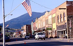
The downtown has been redeveloped since the mid-1980s for historic and cultural tourism, as the Red Lodge Commercial Historic District. The buildings in downtown Red Lodge fell into disrepair in large part because population had dropped from its 1915 peak of 6,000 people to about 2,000. [11]

As of 2006, an estimate suggests that the population of Red Lodge may increase from about 1,200 people in the winter to over 1,800 people during the summer tourist season, arriving via the Beartooth Highway.

Red Lodge was heavily affected by the 2022 Montana floods. [12]

Geography

Red Lodge is located in the Beartooth Mountains. Rock Creek flows along the eastern border. Near town, in the Custer Gallatin National Forest, is Granite Peak, the highest point in Montana. Grizzly Peak, of the Red Lodge Mountain ski area, is one of several mountains surrounding the town.

June 14, 2022, flood damage Montana flood.jpg
June 14, 2022, flood damage

According to the United States Census Bureau, the city has a total area of 2.80 square miles (7.25 km2), all land. [13]

Climate

Red Lodge experiences a continental climate (Köppen Dfb) with cold, somewhat dry winters and warm, wetter summers. Summers are cooler than in areas of Montana further north, due to the high elevation. Winters however, are milder than areas further to the east due to the chinook wind influence, as with most of Montana.

Climate data for Red Lodge, Montana, 19912020 normals, extremes 1894present
MonthJanFebMarAprMayJunJulAugSepOctNovDecYear
Record high °F (°C)70
(21)
70
(21)
72
(22)
80
(27)
88
(31)
96
(36)
101
(38)
98
(37)
97
(36)
86
(30)
80
(27)
71
(22)
101
(38)
Mean maximum °F (°C)53.9
(12.2)
54.3
(12.4)
61.6
(16.4)
70.5
(21.4)
77.9
(25.5)
85.2
(29.6)
90.9
(32.7)
90.0
(32.2)
85.5
(29.7)
74.7
(23.7)
61.5
(16.4)
54.6
(12.6)
91.5
(33.1)
Mean daily maximum °F (°C)37.5
(3.1)
36.7
(2.6)
45.7
(7.6)
53.3
(11.8)
62.0
(16.7)
71.6
(22.0)
81.2
(27.3)
80.6
(27.0)
71.2
(21.8)
56.4
(13.6)
43.1
(6.2)
35.7
(2.1)
56.3
(13.5)
Daily mean °F (°C)25.7
(−3.5)
25.5
(−3.6)
33.7
(0.9)
40.9
(4.9)
49.3
(9.6)
57.6
(14.2)
65.6
(18.7)
64.7
(18.2)
56.4
(13.6)
43.9
(6.6)
32.1
(0.1)
25.0
(−3.9)
43.4
(6.3)
Mean daily minimum °F (°C)13.9
(−10.1)
14.3
(−9.8)
21.7
(−5.7)
28.5
(−1.9)
36.6
(2.6)
43.7
(6.5)
49.9
(9.9)
48.7
(9.3)
41.6
(5.3)
31.4
(−0.3)
21.2
(−6.0)
14.2
(−9.9)
30.5
(−0.8)
Mean minimum °F (°C)−9.9
(−23.3)
−8.7
(−22.6)
−1.5
(−18.6)
12.9
(−10.6)
23.7
(−4.6)
31.2
(−0.4)
40.9
(4.9)
37.5
(3.1)
28.3
(−2.1)
12.4
(−10.9)
−2.3
(−19.1)
−9.7
(−23.2)
−20.4
(−29.1)
Record low °F (°C)−38
(−39)
−42
(−41)
−30
(−34)
−10
(−23)
7
(−14)
20
(−7)
30
(−1)
22
(−6)
8
(−13)
−13
(−25)
−25
(−32)
−42
(−41)
−42
(−41)
Average precipitation inches (mm)0.84
(21)
1.14
(29)
1.78
(45)
2.77
(70)
4.72
(120)
2.59
(66)
1.45
(37)
1.01
(26)
1.63
(41)
2.34
(59)
1.39
(35)
1.00
(25)
22.66
(574)
Average snowfall inches (cm)13.5
(34)
19.4
(49)
20.2
(51)
25.5
(65)
6.2
(16)
0.6
(1.5)
0.0
(0.0)
0.0
(0.0)
2.1
(5.3)
17.0
(43)
18.7
(47)
18.7
(47)
141.9
(358.8)
Average precipitation days (≥ 0.01 in)4.64.87.19.312.111.49.98.17.16.65.75.792.4
Average snowy days (≥ 0.1 in)5.15.26.15.52.50.40.00.00.73.15.05.839.4
Source 1: NOAA [14]
Source 2: National Weather Service [15]

Demographics

Historical population
CensusPop.Note
1890 624
1900 2,152244.9%
1910 4,860125.8%
1920 4,515−7.1%
1930 3,026−33.0%
1940 2,950−2.5%
1950 2,730−7.5%
1960 2,278−16.6%
1970 1,844−19.1%
1980 1,8962.8%
1990 1,9583.3%
2000 2,17711.2%
2010 2,125−2.4%
2020 2,2576.2%
source: [16]
U.S. Decennial Census [17]

Red Lodge is part of the Billings Metropolitan Statistical Area.

2010 census

As of the census [18] of 2010, there were 2,125 people, 1,082 households, and 513 families residing in the city. The population density was 758.9 inhabitants per square mile (293.0/km2). There were 1,675 housing units at an average density of 598.2 per square mile (231.0/km2). The racial makeup of the city was 96.3% White, 0.4% African American, 0.6% Native American, 0.3% Asian, 0.1% Pacific Islander, 0.6% from other races, and 1.6% from two or more races. Hispanic or Latino of any race were 1.9% of the population.

There were 1,082 households, of which 19.5% had children under the age of 18 living with them, 35.6% were married couples living together, 8.2% had a female householder with no husband present, 3.6% had a male householder with no wife present, and 52.6% were non-families. 43.8% of all households were made up of individuals, and 14.4% had someone living alone who was 65 years of age or older. The average household size was 1.92 and the average family size was 2.62.

The median age in the city was 47.3 years. 16.8% of residents were under the age of 18; 6.4% were between the ages of 18 and 24; 22.8% were from 25 to 44; 34.4% were from 45 to 64; and 19.8% were 65 years of age or older. The gender makeup of the city was 49.4% male and 50.6% female.

2000 census

As of the census [19] of 2000, there were 2,177 people, 1,020 households, and 528 families residing in the city. The population density was 846.0 inhabitants per square mile (326.6/km2). There were 1,415 housing units at an average density of 549.9 per square mile (212.3/km2). The racial makeup of the city was 96.14% White, 0.41% African American, 1.10% Native American, 0.46% Asian, 0.46% from other races, and 1.42% from two or more races. Hispanic or Latino of any race were 1.98% of the population.

There were 1,020 households, out of which 22.8% had children under the age of 18 living with them, 41.3% were married couples living together, 7.3% had a female householder with no husband present, and 48.2% were non-families. 39.8% of all households were made up of individuals, and 15.0% had someone living alone who was 65 years of age or older. The average household size was 2.04 and the average family size was 2.76.

In the city, the population was spread out, with 20.2% under the age of 18, 6.9% from 18 to 24, 28.6% from 25 to 44, 24.9% from 45 to 64, and 19.4% who were 65 years of age or older. The median age was 42 years. For every 100 females, there were 93.5 males. For every 100 females age 18 and over, there were 88.9 males.

The median income for a household in the city was $31,750, and the median income for a family was $40,260. Males had a median income of $30,250 versus $20,208 for females. The per capita income for the city was $19,090. About 6.9% of families and 9.7% of the population were below the poverty line, including 12.4% of those under age 18 and 9.3% of those age 65 or over.

Government

Red Lodge is an incorporated city. It operates on a Charter Form of Government. [20] There are six members of the city council, elected from one of three wards of roughly equal population. [21] There are two council members from each ward. The mayor is elected in a citywide vote and serves 2 years.

Education

Red Lodge is served by three public schools: Mountain View Elementary School, Roosevelt Middle School, and Red Lodge High School. [22] For the 2021-2022 school year, there were 319 students enrolled in kindergarten to 8th grade. [23] The high school, 9th to 12th grade, had 180 students. [24] The team name for Red Lodge schools is the Rams. [25]

Red Lodge Carnegie Library serves the area. [26]

The Yellowstone Bighorn Research Association's Geology Field Station is located south of Red Lodge. [27]

Red Lodge Mountain Palisades Red Lodge Palisades.jpg
Red Lodge Mountain Palisades
The Beartooth Highway in the Beartooth Mountains Beartooth Highway.jpg
The Beartooth Highway in the Beartooth Mountains

Outdoor recreation

Red Lodge is well known for many outdoor recreation opportunities: skiing, mountain biking, fly fishing, and backpacking are nearby. They are home to the national skijoring finals. [28]

Infrastructure

U.S. Route 212 runs through the town from north to south. West of town it becomes Beartooth Highway, a National Scenic Byway. Montana Highway 78 enters town from Columbus to the north. Secondary Highway 308 connects the town to Belfry.

Red Lodge Airport is a public use airport located one mile (1.85 km) northwest of town. [29] The nearest commercial airport is Billings Logan International Airport.

The Beartooth Billings Clinic provides medical care for the area. [30] Services include emergency, same-day care, mental health and primary care.

Media

Radio

Newspapers

Notable people

Related Research Articles

<span class="mw-page-title-main">Yellowstone County, Montana</span> County in Montana, United States

Yellowstone County is the most populous county in the U.S. state of Montana. As of the 2020 census, the population was 164,731. Its county seat is Billings, the state's most populous city. Like the nearby park, Yellowstone County is named after the Yellowstone River which roughly bisects the county, flowing southwest to northeast. The river, in turn, was named for the yellow sandstone cliffs in what is now Yellowstone County.

<span class="mw-page-title-main">Carbon County, Montana</span> County in Montana, United States

Carbon County is a county located in the U.S. state of Montana. As of the 2020 census, the population was 10,473. Its county seat is Red Lodge.

<span class="mw-page-title-main">Belfry, Montana</span> Census-designated place in Montana, United States

Belfry is a census-designated place (CDP) in Carbon County, Montana, United States. It is part of the Billings, Montana Metropolitan Statistical Area. The population was 218 at the 2010 census. It is located approximately 11 miles (18 km) from the Wyoming border, roughly halfway between Billings, Montana and Cody, Wyoming.

<span class="mw-page-title-main">Fromberg, Montana</span> Town in Carbon County, Montana, United States

Fromberg is a town in Carbon County, Montana, United States. As of the 2020 census, the population of the town was 392.

<span class="mw-page-title-main">Joliet, Montana</span> Town in Montana, United States

Joliet is a town in Carbon County, Montana, United States. It is part of the Billings, Montana Metropolitan Statistical Area. The population was 577 at the 2020 census.

<span class="mw-page-title-main">Glendive, Montana</span> City in Montana, United States

Glendive is a city in and the county seat of Dawson County, Montana, United States, and home to Dawson Community College. Glendive was established by the Northern Pacific Railway when they built the transcontinental railroad across the northern tier of the western United States from Minnesota to the Pacific Coast. The town was the headquarters for the Yellowstone Division that encompassed 875 route miles (1,408 km); 546 (879) in main line and 328 (528) in branches with the main routes from Mandan, North Dakota, to Billings, Montana, and from Billings to Livingston. The town of Glendive is an agricultural and ranching hub of eastern Montana sited between the Yellowstone River and the Badlands. Makoshika State Park is located just east of Glendive.

<span class="mw-page-title-main">Livingston, Montana</span> City in Park County, Montana, United States

Livingston is a city and county seat of Park County, Montana, United States. It is in southwestern Montana, on the Yellowstone River, north of Yellowstone National Park. As of the 2020 census, the population of the city was 8,040.

<span class="mw-page-title-main">Sidney, Montana</span> City in Montana, United States

Sidney is a city in and the county seat of Richland County, Montana, United States, less than 10 mi (16 km) west of the North Dakota border. The population was 6,346 at the 2020 census. The city lies along the Yellowstone River and is in proximity to the badlands of the Dakotas. Sidney is approximately midway between Glendive, Montana and Williston, North Dakota.

<span class="mw-page-title-main">Forsyth, Montana</span> City in Montana, United States

Forsyth is a city in and the county seat of Rosebud County, Montana, United States. The population was 1,647 at the 2020 census. Forsyth was established in 1876 as the first settlement on the Yellowstone River, and in 1882 residents named the town after General James William Forsyth who commanded Fort Maginnis, Montana during the Indian Wars and the 7th Cavalry at the Wounded Knee Massacre. The town has long been a transportation nexus, starting with steamboats on the river and progressing to the Northern Pacific Railway and Interstate 94.

<span class="mw-page-title-main">Absarokee, Montana</span> CDP in Montana, United States

Absarokee is a census-designated place (CDP) in Stillwater County, Montana, United States, approximately 14 miles (23 km) south of Columbus on Highway 78. It is named after the Crow Indians who formerly inhabited the land. The population was 1,234 at the 2000 census. The Stillwater Mine, operated by the Stillwater Mining Company, is located near Absarokee.

<span class="mw-page-title-main">Columbus, Montana</span> Town in Montana, United States

Columbus is a town in and the county seat of Stillwater County, Montana, United States. The population was 1,857 at the 2020 census.

<span class="mw-page-title-main">Park City, Montana</span> CDP in Montana, United States

Park City is a census-designated place (CDP) in Stillwater County, Montana, United States. The population was 870 at the 2000 census.

<span class="mw-page-title-main">Billings, Montana</span> Largest city in Montana, U.S.

Billings is the most populous city in the U.S. state of Montana, with a population of 117,116 as of the 2020 census. Located in the south-central portion of the state, it is the seat of Yellowstone County and the principal city of the Billings Metropolitan Area, which had a population of 184,167 in the 2020 census. With one of the largest trade areas in the United States, Billings is the trade and distribution center for much of Montana east of the Continental Divide. Billings is also the largest retail destination for much of the same area. The Billings Chamber of Commerce claims the area of commerce covers more than 125,000 square miles (320,000 km2). In 2009, it was estimated to serve over 500,000 people.

<span class="mw-page-title-main">Huntley, Montana</span> CDP in Montana, United States

Huntley is a census-designated place (CDP) in Yellowstone County, Montana, United States. The population was 411 at the 2000 census. Huntley lent its name to the Huntley Project, a federal irrigation project that began delivering water to the arid district in 1907. Today, Huntley is an eastern suburb of Billings and is located east of Shepherd and west of Worden.

<span class="mw-page-title-main">Laurel, Montana</span> City in Montana, United States

Laurel is a city in Yellowstone County, Montana, United States. It is the third largest community in the Billings Metropolitan Statistical Area, and is located in the Yellowstone Valley, as an east–west terminal division point of the BNSF Railway. The population was 7,222 at the 2020 census.

<span class="mw-page-title-main">Lockwood, Montana</span> CDP in Montana, United States

Lockwood is a census-designated place (CDP) in Yellowstone County, Montana, United States. It is not an organized city or town. The population was 7,195 at the 2020 census.The population was 7,222 at the 2020 census. Lockwood is a suburb of Billings and is the second largest community in the Billings Metropolitan Statistical Area. Annexation of Lockwood to Billings has been studied; however, the June 2009 Billings City Council Annexation Plan states that the city has no plans to annex Lockwood in the foreseeable future. Lockwood is the site of a major Exxon refinery.

<span class="mw-page-title-main">Worden, Montana</span> CDP in Montana, United States

Worden is a census-designated place (CDP) in Yellowstone County, Montana, United States. The population was 582 at the 506 at the 2020 census. Worden, along with Ballantine, Huntley, and Pompey's Pillar, is part of the Huntley Project, an irrigation district established by the United States Bureau of Reclamation in 1907.

<span class="mw-page-title-main">Beartooth Highway</span> Scenic road in Montana and Wyoming, United States

The Beartooth Highway is an All-American Road in the western United States on a section of U.S. Route 212 in Montana and Wyoming between Red Lodge and the Northeast entrance of Yellowstone National Park. It crests at Beartooth Pass in Wyoming at 10,947 feet (3,337 m) above sea level, and was called "the most beautiful drive in America," by late CBS News correspondent Charles Kuralt. Because of heavy snowfall at the top, the pass is usually open for about five months per year, from mid-May to mid-October, weather conditions permitting.

<span class="mw-page-title-main">U.S. Route 212</span> U.S. Numbered Highway in Montana, Wyoming, South Dakota and Minnesota, United States

U.S. Route 212 (US 212) is a spur of US 12. It runs for 949 miles (1,527 km) from Yellowstone National Park to Minnesota Highway 62 at Edina, Minnesota. It does not intersect US 12 now, but it once had an eastern terminus at US 12 in St. Paul, Minnesota. US 212 passes through the states of Minnesota, South Dakota, Wyoming, and Montana. It goes through the cities of Watertown, South Dakota and Billings, Montana.

<span class="mw-page-title-main">Cooke City, Montana</span> Census-designated place in Montana, United States

Cooke City is an unincorporated community and census-designated place (CDP) in Park County, Montana, United States. As of the 2020 census, it had a population of 77. Prior to 2010, it was part of the Cooke City-Silver Gate CDP.

References

  1. 1 2 3 4 U.S. Geological Survey Geographic Names Information System: Red Lodge, Montana
  2. "ArcGIS REST Services Directory". United States Census Bureau. Retrieved September 5, 2022.
  3. "Profile of Red Lodge, Montana in 2020". United States Census Bureau. Archived from the original on June 26, 2022. Retrieved June 26, 2022.
  4. Blevins, Bruce. An Early History of Red Lodge, Montana. WIM: Powell, 1988, 3-6. No ISBN.
  5. Lutz, Dennis. Montana Post Offices and Postmasters. Rochester: Johnson, 1986, 41. No ISBN.
  6. Christensen, Bonnie. Red Lodge and the Mythic West. Lawrence: U of Kansas P, 2000, xii. ISBN   978-0-7006-1198-0
  7. "Gapers Block : GB Book Club : Chicago Books - Events".
  8. Blevins, Bruce H. Beartooth Highway Experiences. Powell: WIM, 2003. ISBN   1-893771-07-5.
  9. https://www.fhwa.dot.gov/publications/publicroads/06jul/03.cfm , Public Roads, July/August 2006, v.70, No.1. Retrieved October 20, 2014.
  10. The Darkest Hour: A Comprehensive Account of the Smith Mine Disaster of 1943, 2nd ed, by Gary D. Robson and Fay Kuhlman (2003). ISBN   0-9659609-1-9
  11. Michels Raffety Architects (1986). Red Lodge commercial historic district : revitalization master plan. Carbon County Historic Preservation Office. Retrieved February 6, 2014.
  12. "Yellowstone National Park closes entrances, residents evacuate Red Lodge as floods sweep across Montana". Montana Public Radio. June 13, 2022. Retrieved June 16, 2022.
  13. "US Gazetteer files 2010". United States Census Bureau. Archived from the original on February 20, 2011. Retrieved December 18, 2012.
  14. "U.S. Climate Normals Quick Access". National Oceanic and Atmospheric Administration. Retrieved August 7, 2022.
  15. "NOAA Online Weather Data". National Weather Service. Retrieved August 7, 2022.
  16. Moffatt, Riley. Population History of Western U.S. Cities & Towns, 1850-1990. Lanham: Scarecrow, 1996, 134.
  17. "Census of Population and Housing". Census.gov. Retrieved July 19, 2016.
  18. "U.S. Census website". United States Census Bureau . Retrieved December 18, 2012.
  19. "U.S. Census website". United States Census Bureau . Retrieved January 31, 2008.
  20. "Mayor". City of Red Lodge. Retrieved October 23, 2023.
  21. "City Council". City of Red Lodge. Retrieved October 23, 2023.
  22. "About". Red Lodge School District 1. Retrieved October 23, 2023.
  23. "Red Lodge Elem". National Center for Education Statistics. Retrieved October 23, 2023.
  24. "Red Lodge H S". National Center for Education Statistics. Retrieved October 23, 2023.
  25. "Member Schools". Montana High School Association. Retrieved April 19, 2021.
  26. "Red Lodge Carnegie Library". City of Red Lodge. Retrieved April 13, 2021.
  27. "Home page". Yellowstone Bighorn Research Association. Retrieved October 23, 2023.
  28. "Home page". Red Lodge Ski-Joring Association. Retrieved October 23, 2023.
  29. "RED (KRED) Red Lodge". FAA. Retrieved October 23, 2023.
  30. "Home page". Beartooth Billings Clinic. Retrieved October 23, 2023.
  31. "KMXE-FM". FCC. Retrieved October 23, 2023.
  32. National Register of Historic Places Form, Hi Bug Historic District, accessed October 25, 2016, at https://mhs.mt.gov/Portals/11/shpo/docs/HiBugHD(BoundaryDecrease).pdf
  33. Crow Killer: The Saga of Liver-Eating Johnson, by Raymond W. Thorpe and Robert Bunker (1983) pg 188. ISBN   978-0-253-20312-0