Ennis is a town in Madison County, Montana, United States, in the southwestern part of the state. The population was 917 at the 2020 census,[5] up from 838 in 2010.
In 1863, gold was discovered in Alder Gulch. This brought on "the rush". Two months later, William Ennis homesteaded the site along the Madison River that was soon to become the town of Ennis, his namesake.[6]
In 1886, a mystery creature was noted for making livestock kills in the Madison Valley. A local rancher, Israel Ammon Hutchins, finally shot and killed the beast, after accidentally shooting one of his cattle, which was on the other side of some brush. A local taxidermist stuffed the canine. Jack Kirby (Hutchins' grandson) tracked the mount to a museum in Pocatello, Idaho, circa 2007.[7][8][9][10]
Avid Aircraft, a manufacturer of homebuilt aircraft, was located in Ennis. The company ceased operations in 2003.
The 2003 Ennis shooting took place on June 14 of that year, when 44-year-old George Harold Davis opened fire outside the Silver Dollar Saloon bar on Main Street. He killed one man and injured six others. He then fled to Missoula County, where he was finally stopped and arrested by police. He was sentenced to eleven life terms for the crime.[11]
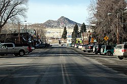
The town is flanked by the Tobacco Root Mountains to the northwest, the Gravelly Range to the southwest and the Madison Range to the east. Approximately 12 miles (19km) north of town, the Madison Dam creates Ennis Lake at the head of Bear Trap Canyon.
According to the U.S. Census Bureau, the town has a total area of 0.74 square miles (1.92km2), of which 0.001 square miles (0.00km2), or 0.14%, are water.[2] The Madison River, one of the three headwater tributaries of the Missouri River, runs along the eastern border of the town.
As of the census[15] of 2010, there were 838 people, 416 households, and 207 families residing in the town. The population density was 1,074.4 inhabitants per square mile (414.8/km2). There were 527 housing units at an average density of 675.6 per square mile (260.9/km2). The racial makeup of the town was 96.9% White, 0.1% African American, 0.8% Native American, 0.2% Asian, 0.5% from other races, and 1.4% from two or more races. Hispanic or Latino of any race were 1.9% of the population.
There were 416 households, of which 20.4% had children under the age of 18 living with them, 36.8% were married couples living together, 9.9% had a female householder with no husband present, 3.1% had a male householder with no wife present, and 50.2% were non-families. 42.5% of all households were made up of individuals, and 20.4% had someone living alone who was 65 years of age or older. The average household size was 1.91 and the average family size was 2.60.
The median age in the town was 49.8 years. 15.8% of residents were under the age of 18; 6% were between the ages of 18 and 24; 22.2% were from 25 to 44; 30.7% were from 45 to 64; and 25.3% were 65 years of age or older. The gender makeup of the town was 49.4% male and 50.6% female.
2000 census
As of the census[16] of 2000, there were 840 people, 367 households, and 219 families residing in the town. The population density was 1,240.2 inhabitants per square mile (478.8/km2). There were 434 housing units at an average density of 640.8 per square mile (247.4/km2). The racial makeup of the town was 97.98% White, 0.48% from other races, and 1.55% from two or more races. Hispanic or Latino of any race were 0.71% of the population.
There were 367 households, out of which 27.2% had children under the age of 18 living with them, 46.9% were married couples living together, 9.5% had a female householder with no husband present, and 40.1% were non-families. 36.0% of all households were made up of individuals, and 11.2% had someone living alone who was 65 years of age or older. The average household size was 2.20 and the average family size was 2.87.
In the town, the population was spread out, with 24.3% under the age of 18, 5.7% from 18 to 24, 23.0% from 25 to 44, 26.3% from 45 to 64, and 20.7% who were 65 years of age or older. The median age was 43 years. For every 100 females there were 90.9 males. For every 100 females age 18 and over, there were 94.5 males.
The median income for a household in the town was $30,735, and the median income for a family was $38,542. Males had a median income of $30,956 versus $16,875 for females. The per capita income for the town was $17,310. About 7.7% of families and 11.9% of the population were below the poverty line, including 10.9% of those under age 18 and 11.7% of those age 65 or over.
Economy
Ennis is the center of a long-standing ranching economy in the Madison River valley. Large cattle and sheep ranches dot the valley north and south of the town along the river. Ennis is also a major tourist attraction and angling destination for fly fishermen targeting rainbow and brown trout. The small town hosts at least three fly shops and numerous resorts that cater to fly anglers with guided fishing trips on the Madison and in nearby Yellowstone National Park. Ennis is home to Willie's Distillery, known for its bourbon and moonshine, and one of the growing number of micro-distilleries in Montana.[17]
Arts and culture
Ennis 4th of July parade 2014
Ennis has a public library, the Madison Valley Public Library.[18]
Events
Ennis has an annual July 4 parade,[19] which includes a rodeo event.
Ennis on the Madison Fly Fishing Festival occurs in August.[20]
The Madison Trifecta is a duathlon held on the 4th of July weekend between Ennis and Virginia City, Montana. A full marathon, the highest elevation run (over 9,000 feet (2,700m)) in the United States, is held in July. The Madison Triathlon is held in August between Ennis and Harrison, Montana.[21]
In October, the annual Hunters Feed takes place the day before rifle season opens.[citation needed]
Tap Into Ennis is Montana's first combined brewery and distillery festival, and includes breweries and distilleries, artists, and local music.[citation needed]
Ennis has a mayor and town commissioners. As of January 2026 the Mayor of Ennis, Montana is Lisa Roberts [23]. Lisa Roberts ran unopposed in November of 2025.
This page is based on this Wikipedia article Text is available under the CC BY-SA 4.0 license; additional terms may apply. Images, videos and audio are available under their respective licenses.