Ennis is a town in Madison County, Montana, United States, in the southwestern part of the state. The population was 917 at the 2020 census.

The Madison River is a headwater tributary of the Missouri River, approximately 183 miles (295 km) long, in Wyoming and Montana. Its confluence with the Jefferson and Gallatin rivers near Three Forks, Montana forms the Missouri River.

Flathead Lake is a large natural lake in northwest Montana, United States.
The Salt River Project (SRP) encompasses two separate entities: the Salt River Project Agricultural Improvement and Power District, an agency of the state of Arizona that serves as an electrical utility for the Phoenix metropolitan area, and the Salt River Valley Water Users' Association, a utility cooperative that serves as the primary water provider for much of central Arizona. It is one of the primary public utility companies in Arizona.

The Swan River is a 95-mile (153 km) long, north-flowing river in western Montana in the United States. The river drains a long isolated valley, known as the Swan Valley, between the Swan Range on the east and the Mission Mountains to the west.

Hebgen Dam is a concrete-core earthen embankment dam in the western United States, located on the Madison River in southwestern Montana. The dam is 85 feet (26 m) tall and 721 feet (220 m) in length; its purpose is to store and regulate water for other downstream reservoirs and hydroelectric power plants. Montana Power Company originally built the dam, PPL Corporation purchased it in 1997 and sold it to NorthWestern Corporation in 2014.

The Yuba River is a tributary of the Feather River in the Sierra Nevada and eastern Sacramento Valley, in the U.S. state of California. The main stem of the river is about 40 miles (64 km) long, and its headwaters are split into three major forks. The Yuba River proper is formed at the North Yuba and Middle Yuba rivers' confluence, with the South Yuba joining a short distance downstream. Measured to the head of the North Yuba River, the Yuba River is just over 100 miles (160 km) long.

Pineview Dam is located in Ogden Canyon, 7 miles (11 km) east of Ogden, Utah, United States.
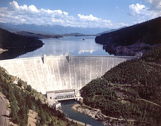
Hungry Horse Dam is an arch dam in the Western United States, on the South Fork Flathead River in the Rocky Mountains of northwest Montana. It is located in Flathead National Forest in Flathead County, about fifteen miles (24 km) south of the west entrance to Glacier National Park, nine miles (14 km) southeast of Columbia Falls, and twenty miles (32 km) northeast of Kalispell. The Hungry Horse project, dam, and powerplant are operated by the U.S. Bureau of Reclamation. The entrance road leading to the dam is located in Hungry Horse.

Yellowtail Dam is a dam across the Bighorn River in south central Montana in the United States. The mid-1960s era concrete arch dam serves to regulate the flow of the Bighorn for irrigation purposes and to generate hydroelectric power. The dam and its reservoir, Bighorn Lake, are owned by the U.S. Bureau of Reclamation.

Rainbow Dam is a hydroelectric dam on the Missouri River, 29 feet (8.8 m) high and 1,055 feet (322 m) long, located six miles northeast of Great Falls in the U.S. state of Montana.

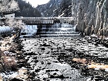
Ryan Dam is a hydroelectric dam on the Missouri River, 10 miles (16 km) downstream from the city of Great Falls in the U.S. state of Montana. The dam is 1,336 feet (407 m) long and 61 feet (19 m) high; its reservoir is 7 miles (11 km) long and has a storage capacity of 5,000 acre-feet (6,200,000 m3). It is a run-of-river dam. The dam is built on the largest of the five Great Falls of the Missouri, the "Big Falls", also sometimes called "Great Falls". Since 1915, the six-unit powerhouse on the left side of the dam has occupied a significant portion of the 87-foot (27 m) high waterfall.

Holter Dam is a hydroelectric straight gravity dam on the Missouri River about 45 miles (72 km) northeast of Helena, Montana, in the United States. The dam, which was built between 1908 and 1918, is 1,364 feet (416 m) long and 124 feet (38 m) high. The reservoir formed by the dam, Holter Lake is 25 miles (40 km) long and has a storage capacity of 243,000 acre-feet (300,000,000 m3) of water when full. The dam is a "run-of-the-river" dam because it can generate electricity without needing to store additional water supplies behind the dam.

Hauser Dam is a hydroelectric straight gravity dam on the Missouri River about 14 miles (23 km) northeast of Helena, Montana, in the United States. The original dam, built between 1905 and 1907, failed in 1908 and caused severe flooding and damage downstream. A second dam was built on the site in 1908 and opened in 1911 and comprises the present structure. The current Hauser Dam is 700 feet (210 m) long and 80 feet (24 m) high. The reservoir formed by the dam, Hauser Lake, is 25 miles (40 km) long, has a surface area of 3,800 acres (1,500 ha), and has a storage capacity of 98,000 acre-feet (121,000,000 m3) of water when full.
Cochrane Dam is a run-of-the river hydroelectric dam on the Missouri River, about 8 miles (13 km) northeast of Great Falls in the U.S. state of Montana. The dam has a concrete gravity design and is 59 feet (18 m) high and 753 feet (230 m) long. Its power station has two generators capable of producing 64 megawatts. Construction of the dam was finished in 1958. Montana Power Company originally built the dam, PPL Corporation purchased it in 1997 and sold it to NorthWestern Corporation in 2014.

Black Eagle Dam is a hydroelectric gravity weir dam located on the Missouri River in the city of Great Falls, Montana. The first dam on the site, built and opened in 1890, was a timber-and-rock crib dam. This structure was the first hydroelectric dam built in Montana and the first built on the Missouri River. The dam helped give the city of Great Falls the nickname "The Electric City." A second dam, built of concrete in 1926 and opened in 1927, replaced the first dam, which was not removed and lies submerged in the reservoir. Almost unchanged since 1926, the dam is 782 feet (238 m) long and 34.5 feet (10.5 m) high, and its powerhouse contains three turbines capable of generating seven megawatts (MW) of power each. The maximum power output of the dam is 18 MW. Montana Power Company built the second dam, PPL Corporation purchased it in 1997 and sold it to NorthWestern Corporation in 2014. The reservoir behind the dam has no official name, but was called the Long Pool for many years. The reservoir is about 2 miles (3.2 km) long, and has a storage capacity of 1,710 acre-feet (2,110,000 m3) to 1,820 acre-feet (2,240,000 m3) of water.

Morony Dam is a hydroelectric gravity dam located on the Missouri River in Cascade County, Montana. The dam is 883 feet (269 m) long and 94 feet (29 m) high, and generates 49 megawatts (MW) of power.
Thompson Falls Dam is a dam in Sanders County, Montana, in the northwestern part of the state.

The Upper North Fork Feather River Project is a hydroelectric scheme in the Sierra Nevada of California, within Lassen and Plumas Counties. The project consists of three dams, five power plants, and multiple conduits and tunnels in the headwaters of the North Fork Feather River, a major tributary of the Feather—Sacramento River systems. The total installed capacity is 362.3 megawatts (MW), producing an annual average of 1,171.9 gigawatt hours (GWh). The project is also contracted for the delivery of irrigation water between March 31 and October 31 of each year. The project is owned and operated by Pacific Gas and Electric Company.