List of state highways in Montana

Last updated

Montana Highway System

MT-3.svg

MT-59.svg

MT-200.svg

Montana highways map.png
Map of main highways within Montana
System information
Maintained by MDT
Formed1942 [1]
Highway names
Interstates Interstate nn (I-nn)
US Highways U.S. Highway n (US n)
State Montana Highway n (MT n)
SecondarySecondary Highway nnn (S-nnnn)
System links

The state highways in Montana are the state highways owned and maintained by the Montana Department of Transportation (MDT) in the US state of Montana.

Contents

Montana's state highways are classified as either primary or secondary. [1] Several of Montana's state highways (both primary and secondary), or sections thereof, have also been designated as part of the National Highway System. [1]

Primary state highways

The square markers used today to identify primary Montana highways are only slightly different from their 1940s and earlier predecessors. The old markers used the word "ROUTE" above the number in big size, the route number in the middle, and the word "MONTANA" from edge-to-edge at the sign bottom. [1] The font used was similar to that used for US routes.

NumberLength (mi) [2] [3] Length (km)Southern or western terminusNorthern or eastern terminusFormedRemovedNotes
MT 1 US 191 near Grayling US 10 near Sappington Replaced by MT 287 (now US 287)
MT-1.svg MT 1 63.652102.438 I-90 in Opportunity I-90 in Drummond 01922-01-011922current
MT-2.svg MT 2 63.241101.777 I-90 in Butte I-90 in Three Forks
MT 3 Idaho border near Heron US 93 in Ravalli Replaced by US 10 Alt
MT-3.svg MT 3 221.770356.904 I-90 in Billings I-15 and US 89 in Great Falls
MT 4 2439 Idaho state line MT 3 in Thompson Falls decommissioned when Idaho truncated SH 4 at Burke; Replaced by Forest Service Road NF-7623 (connects to Burke) and S-471
MT-5.svg MT 5 65.573105.530 MT 13 in Scobey ND 5 in Westby
MT 6 US 10 Alternate in Townsend US 10 in Forsyth Replaced by US 12
MT-7.svg MT 7 80.585129.689 S-323 in Ekalaka I-94 in Wibaux 01930-01-011930current
MT 8 US 87 in Crow Agency MT 22 near Olive Replaced by US 212
MT 9 Lolo Pass US 93 at Lolo Replaced by S-412 (now US 12)
MT 11 US 89 in Vaughn Alberta border at Sweetgrass 01932-01-011932Replaced by US 91
MT 11
MT-13.svg MT 13 112.507181.062 MT 200 in Circle Hwy 36 at the Saskatchewan border
MT-13W.svg MT 13W 5.7979.329 US 2 in Wolf Point MT 13 in Bridge Park 01994-01-011994Replaced by MT 25
MT 14 US 10 at Glendive North Dakota border at Fairview Replaced by MT 16 and MT 23N (later MT 20; now MT 200)
MT 15 US 87 in Stanford US 2 in Chester Replaced by S-230 (now MT 80) and S-223
MT-16.svg MT 16 152.371245.217 I-94 Bus. in Glendive Hwy 6 at the Saskatchewan border
MT 17 location unknown
MT-17.svg MT 17 14.08222.663 US 89 near Kennedy Creek Hwy 6 at the Alberta border
MT 18 US 87 in Grass Range US 10/MT 14 in Glendive Replaced by MT 20 (now MT 200) and MT 20S (now MT 200S)
MT 19 US 10 in Big Timber US 2/MT 39 in Malta Replaced by US 191
MT-19.svg MT 19 21.48234.572 US 87 and MT 200 near Grass Range US 191 near Roy
MT 20 US 10 in Bonner US 89 near Great Falls Replaced by MT 200
MT 21 US 10 in Columbus MT 6 at Ryegate Replaced by S-300 and S-306
MT-21.svg MT 21 20.77633.436 US 287 near Augusta MT 200 in Simms
MT 22 Wyoming border at Alzada Saskatchewan border at Port of Ophiem Replaced by US 212, MT 59, S-341, and MT 24
MT-23.svg MT 23 7.52712.114 MT 16 and MT 200 near Sidney ND 68 at the North Dakota borderFrom 1951 to 1958, continued west to Circle
MT 23N North Dakota border at Fairview Replaced by MT 20 (now MT 200)
MT 23S ND 68 at the North Dakota borderReplaced by MT 23
MT 24 5893 MT 37 at Jennings US 2 in Marion
MT-24.svg MT 24 134.098215.810 MT 200 near Brockway Hwy 2 at the Saskatchewan border
MT-24W.svg MT 24W 2.8924.654 MT 24 south of Glasgow US 2 in Glasgow01994-01-011994Replaced by MT 42
MT 25 US 87 in Billings US 87 in Lewistown
MT-25.svg MT 25 5.7979.329 US 2 in Wolf Point MT 13 in Bridge Park 01994-01-011994current
MT 26 MT 3 in Trout Creek US 2 in Kootenai National Forest
MT 27 MT 19 in Winifred MT 29 in Big Sandy Replaced by S-226
MT-28.svg MT 28 46.73475.211 MT 200 near Plains US 93 in Elmo 01924-01-011924current
MT 29 US 87/US 89 in Great Falls Port of Wildhorse Replaced by US 87
MT 30 US 12 near Miles City South Dakota border near Mill Iron
MT 31 US 10 in Drummond MT 35 near Bigfork Replaced by S-271 and MT 83
MT 32 Yellowstone National Park at Silver Gate US 310 at Rockvale Replaced by US 212
MT 33 US 91/MT 20 in Wolf Creek US 89 in Choteau Replaced by US 287
MT 34 MT 41 in Twin Bridges MT 287 in Ennis Replaced by rerouted MT 287
MT-35.svg MT 35 50.66981.544 US 93 in Polson US 2 in Evergreen
MT 36 US 93 near Gibbons Pass US 91 in Dillon Replaced by MT 43 and S-278
MT-37.svg MT 37 67.048107.903 US 2 in Libby US 93 in Eureka
MT-38.svg MT 38 53.83586.639 US 93 in Grantsdale MT 1 in Porters Corner 01924-01-011924currentSkalkaho Highway
MT 39 Port of Morgan at the Saskatchewan border Hysham Replaced by MT 19 (later S-242) and S-245
MT-39.svg MT 39 51.16382.339 US 212 in Lame Deer North of I-94 near Forsyth 01977-01-011977current
MT-40.svg MT 40 4.5057.250 US 93 south of Whitefish US 2 west of Columbia Falls
MT-41.svg MT 41 54.51287.729 I-15 Bus. in Dillon MT 2 in Vendome Station
MT 42 location unknown
MT-42.svg MT 42 2.8924.654 MT 24 south of Glasgow US 2 in Glasgow01994-01-011994current
MT-43.svg MT 43 77.462124.663 US 93 at Lost Trail Pass I-15 near Divide Last mile near western terminus with US 93 is in Idaho.
MT 44 location unknown
MT-44.svg MT 44 28.39045.689 US 93 north of Dupuyer I-15 east of Valier
MT 45 MT 8 in Lame Deer US 10 in Forsyth Replaced by S-315 (now MT 39)
MT 46 location unknown
MT-47.svg MT 47 31.43750.593 I-90 in Hardin I-94 east of Custer
MT-48.svg MT 48 6.83911.006 MT 1 near Anaconda I-90 near Warm Springs
MT 49 location unknown
MT-49.svg MT 49 11.73418.884 US 2 in East Glacier Park US 89 north of Kiowa
MT 50 MT 13 southeast of Wolf Point US 2 east of Wolf Point Replaced by MT 13
MT 50 Idaho border at Raynolds Pass US 287 west of Lake Hebgen Replaced by MT 87
MT-55.svg MT 55 12.99620.915 MT 41 north of Silver Star I-90 at Whitehall
MT-56.svg MT 56 34.64655.757 MT 200 west of Noxon US 2 east of Troy 01977-01-011977current
MT-59.svg MT 59 195.389314.448 WYO 59 at the Wyoming border MT 200 at Jordan
MT-64.svg MT 64 9.03914.547 Big Sky Resort US 191 near Big Sky Resort
MT-66.svg MT 66 50.02280.503 US 191 south of Landusky US 2 at Fort Belknap
MT-67.svg MT 67 1.7552.824 US 2 in Shelby I-15 in Shelby
MT-68.svg MT 68 1.4942.404 I-15 south of Cascade I-15 north of Cascade
MT-69.svg MT 69 38.39561.791 MT 55 at Whitehall I-15 at Boulder
MT-72.svg MT 72 21.40834.453 WYO 120 at the Wyoming border US 310 south of Bridger 01977-01-011977current
MT-77.svg MT 77 1.9913.204 Hot Springs MT 28 east of Hot Springs 01977-01-011977current
MT-78.svg MT 78 47.71476.788 US 212 at Red Lodge I-90 at Columbus 01977-01-011977current
MT-80.svg MT 80 67.172108.103 US 87 at Stanford US 87 at Fort Benton
MT-81.svg MT 81 42.44668.310 MT 80 near Coffee Creek US 191 at Brooks
MT-82.svg MT 82 6.86211.043 US 93 north of Somers MT 35 north of Bigfork 01977-01-011977current
MT-83.svg MT 83 91.118146.640 MT 200 at Clearwater Junction MT 35 north of Bigfork 01977-01-011977current
MT-84.svg MT 84 28.90446.516 US 287 in Norris US 191/MT 85 near Four Corners
MT-85.svg MT 85 6.70410.789 US 191/MT 84 near Four Corners I-90 at Belgrade
MT-86.svg MT 86 37.49860.347 US 191/I-90 Bus. in Bozeman US 89 near Wilsall
MT-87.svg MT 87 8.57113.794 SH 87 at the Idaho border US 287 west of Quake Lake 01987-01-011987current
MT 110 US 10 near Opportunity US 10 in Drummond Replaced by US 10 Alternate
MT-117.svg MT 117 13.13821.144 MT 24 at Fort Peck US 2 at Nashua
MT-135.svg MT 135 21.54934.680 I-90 at St. Regis MT 200 near Paradise 01977-01-011977current
MT-141.svg MT 141 32.46852.252 US 12 at Avon MT 200 north of Helmville 01977-01-011977current
MT 187 US 10 in Bozeman US 89 in Wilsall Replaced by S-293 (now MT 86)
MT 191 US 191 near Grayling US 10 near Sappington Replaced by MT 1 (later MT 287, now US 287)
MT-200.svg MT 200 706.6241,137.201 SH 200 at the Idaho border east of Cabinet, Idaho ND 200 at Fairview 01967-01-011967currentLongest state highway in Montana
MT-287.svg MT 287 48.82278.571 MT 41 at Twin Bridges US 287 at Ennis
MT 789 Wyoming border south of Warren Alberta border at Sweetgrass Part of US 789 corridor

Special routes

NumberLength (mi)Length (km)Southern or western terminusNorthern or eastern terminusFormedRemovedNotes
MT 20S MT 20 east of Circle US 10/I-94 Bus. in Glendive Replaced by MT 200S
MT-200S.svg MT 200S 48.67478.333 MT 200 east of Circle I-94 Bus. in Glendive 01967-01-011967current
MT 287A 4674 MT 287 at Ennis I-90/US 10 near Three Forks 01961-01-01196101965-01-011965Former section of MT 287; replaced by US 287
  •       Former

Secondary state highways

S-486 at Columbia Falls, August 2013 Montana Secondary Highway 486 in Columbia Falls, MT.jpg
S-486 at Columbia Falls, August 2013

Montana's secondary system was established in 1942, [4] but secondary highways (S routes) were not signed until the 1960s. [1] S route designations first appeared on the state highway map in 1960 [5] and are abbreviated as "S-nnn". Route numbers 201 and higher are, with very few exceptions, exclusively reserved for S routes. Notable exceptions include, MT 287, and the former MT 789.

The highway markers for Montana's Secondary Highways are distinctive in that the route number appears in black on a white down-pointing arrowhead. [1] (Early markers were white numbers on black arrowheads with the word Montana in the flat top of the inverted arrowhead and Secondary appearing below the route number on the shields.)

See also

Related Research Articles

<span class="mw-page-title-main">Concurrency (road)</span> Road bearing more than one route number

A concurrency in a road network is an instance of one physical roadway bearing two or more different route numbers. When two roadways share the same right-of-way, it is sometimes called a common section or commons. Other terminology for a concurrency includes overlap, coincidence, duplex, triplex, multiplex, dual routing or triple routing.

The South Carolina State Highway System is the fourth largest state-maintained system of state highways in the country. It consists of Interstates, U.S. highways, state highways, and secondary roads, totaling approximately 41,500 miles (66,800 km).

<span class="mw-page-title-main">Montana Highway 81</span>

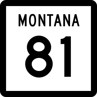
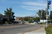
Montana Highway 81 (MT 81) is a state highway in the U.S. state of Montana. The highway begins at an intersection with MT 80 north of the hamlet of Arrow Creek. The highway extends eastward from this point for approximately 42 miles (68 km), ending at an intersection with U.S. Route 191 (US 191) at the post office of Brooks. The landscape traversed by MT 81 is uneven and largely rural, used mainly for agriculture and livestock grazing. For much of its length, the highway is roughly paralleled by the main line of Central Montana Rail, which is headquartered in Denton.

<span class="mw-page-title-main">Montana Highway 2</span>

Montana Highway 2 (MT 2) is a 63.241-mile-long (101.777 km) state highway in the southern part of the U.S. state of Montana. It extends from Interstate 15 (I-15) and I-90 in Butte to I-90 in Three Forks. Previously, this roadway was a part of U.S. Route 10 (US 10).

<span class="mw-page-title-main">Montana Highway 84</span>

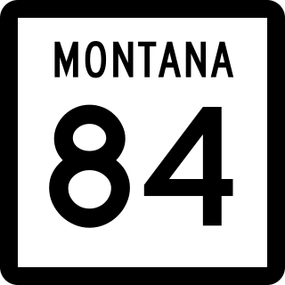
Highway 84 is a 28.904-mile-long (46.516 km) east–west state highway in the U.S. State of Montana. MT 84's western terminus is at U.S. Route 287 in the small community of Norris and the eastern terminus is at US 191 and MT 85 at Four Corners. The highway's eastern terminus, about 7 miles (11 km) west of Bozeman, is a location known locally as "Four Corners." From Four Corners, US 191 runs east to Bozeman, and south to West Yellowstone; Highway 84 travels west to Norris; and Montana Highway 85 runs north to Belgrade.

<span class="mw-page-title-main">Montana Highway 82</span>

Montana Highway 82 (MT 82) is a state highway in the U.S. state of Montana connecting U.S. Highway 93 (US 93) north of Somers to MT 35 north of Bigfork.

<span class="mw-page-title-main">Montana Highway 87</span> State highway in Montana

Montana Highway 87 (MT 87) is a primary state highway in Madison County in Montana, United States. The highway travels through mainly rural areas in Raynolds Pass, from the Montana–Idaho state line to an intersection with U.S. Route 287 (US 287). The route travels through a portion of Gallatin National Forest. In 1922, a road in the location of MT 87 was added to the highway system, and a few years later the road was designated as portions of two early auto trails. In 1959, the route was rapidly improved due to the collapse of US 287 nearby. During 1967, much of the highway was reconstructed along its current location.

<span class="mw-page-title-main">Montana Highway 80</span>

Montana Highway 80 is a 67.172-mile-long (108.103 km) north–south state highway in the U.S. State of Montana. MT 80's southern terminus is at U.S. Route 87, MT 3 and MT 200 in the community of Stanford and the northern terminus is at US 87 in the town of Fort Benton. The landscape is hilly and rural, and largely used for wheat farming; the road also passes through Arrow Creek Canyon and near the Highwood Mountains. Between Arrow Creek and Geraldine, MT 80 is roughly paralleled by the main line of Central Montana Rail.

<span class="mw-page-title-main">Montana Highway 78</span>

Montana Highway 78 in the U.S. state of Montana is a state highway running in a northerly direction from an intersection with U.S. Highway 212 (US 212) at the city of Red Lodge. It runs through Roscoe and Absarokee. The highway extends about 49 miles (79 km) to a northern terminus at Interstate 90 (I-90) in the town of Columbus.

<span class="mw-page-title-main">Montana Highway 72</span>

Montana Highway 72 in the U.S. State of Montana is a route running northerly from the Wyoming state line to an intersection with U.S. Route 310 about one mile (1.6 km) south of the town of Bridger, a distance of approximately 21 miles (34 km). At the state line, the road becomes Wyoming Highway 120, which continues 38 miles (61 km) to the town of Cody.

<span class="mw-page-title-main">Montana Highway 69</span>

Montana Highway 69 (MT 69) is a route running northerly from an intersection with MT 55 in the community of Whitehall. The highway extends approximately 38 miles (61 km) to an intersection with Interstate 15 (I-15) at the northern edge of the town of Boulder. Most of the route follows the Boulder River valley, a scenic and relatively unspoiled rural landscape.

<span class="mw-page-title-main">Montana Highway 66</span> Highway in Montana

Montana Highway 66 is a 50-mile-long (80 km) state highway in the US state of Montana. It begins at an intersection with U.S. Highway 191 in far southwestern Phillips County and runs northerly to the town of Fort Belknap in Blaine County. Approximately 40 miles (64 km) of the northern end of the route is within the boundaries of the Fort Belknap Indian Reservation, running through the bulk of its territory.

<span class="mw-page-title-main">U.S. Route 287 in Montana</span> U.S. Highway in Montana

U.S. Route 287 (US 287) is a north-south United States Numbered Highway in the state of Montana. It extends approximately 281.2 miles (452.5 km) from Yellowstone National Park north to U.S. Route 89 in Choteau, 100 miles (160 km) south of the Canadian border.

<span class="mw-page-title-main">Transportation in Montana</span>

Transportation in Montana comprises many different forms of travel. Montana shares a long border with Canada, hence international crossings are prevalent in the northern section of the state; there are 13 road crossings and one rail crossing.

<span class="mw-page-title-main">Montana Highway 287</span> State highway in Montana

Montana Highway 287 is a state highway in the U.S. state of Montana. The highway runs 42.822 miles (68.915 km) from MT 41 in Twin Bridges east to U.S. Route 287 in Ennis. MT 287 is the primary east–west highway of Madison County. The highway connects the county's four towns, including Sheridan and the county seat of Virginia City. The course of MT 287 follows the ultimate portions of two trails that met in Virginia City, the center of the Alder Gulch gold rush of the mid-1860s and the second territorial capital of Montana. Parts of the highway were improved from rudimentary roads around 1920 from Virginia City to Ennis. This connection became the first portion of Montana Highway 34 in the early 1930s; the highway was extended west to Twin Bridges in the late 1930s. MT 34 was reconstructed from Twin Bridges through Alder to Virginia City in the late 1930s and early 1940s and between Virginia City and Ennis in the late 1940s to mid-1950s. The MT 287 designation was first applied to a cross-state route from West Yellowstone to Canada in the late 1950s. The highway was rerouted in place of MT 34 in the early 1960s. MT 287 was replaced by US 287 along much of the cross-state corridor in the mid-1960s. The highway extended north of Twin Bridges to Whitehall until the late 1970s, when it achieved its current length.

<span class="mw-page-title-main">Montana Highway 135</span> State highway in Montana, United States

Montana Highway 135 (MT 135) is a 21.5-mile-long (34.6 km) state highway in western Montana. It begins at Interstate 90 (I-90) in St. Regis and ends at MT 200 near Paradise. The highway runs along the bank of the Clark Fork River and through Lolo National Forest.

<span class="mw-page-title-main">Montana Highway 28</span>

Montana Highway 28 (MT 28) is an approximately 46.7-mile-long (75.2 km) state highway in the west of the US state of Montana. It begins at MT 200 in Plains and ends at U.S. Highway 93 (US 93) in Elmo; all but the first 7.5 miles (12.1 km) are within the Flathead Indian Reservation. It serves as a key link in two alternate routes between Spokane, Washington, and Kalispell.

<span class="mw-page-title-main">Montana Highway 77</span>

Montana Highway 77 (MT 77), also known as Hot Springs Road, is an approximately 1.99-mile-long (3.20 km) state highway in the west of the US state of Montana, and it is a spur route to connect MT 28 to the city of Hot Springs. The entire route is within the Flathead Indian Reservation.

References

  1. 1 2 3 4 5 6 Multimodal Planning Bureau, Rail, Transit & Planning Division (March 2017). "A Guide to Functional Classification, Highway Systems and Other Route Designations in Montana" (PDF). Montana Department of Transportation. pp. 5–6. Retrieved April 8, 2019.
  2. Montana Department of Transportation (January 19, 2022). "ALTIS Road Log Report" (PDF). Helena: Montana Department of Transportation. Retrieved March 6, 2017.
  3. "Montana Off System Routes" (GIS data). Montana Department of Transportation. Retrieved April 8, 2017.
  4. "Federal-Aid Road Log" (PDF). Montana Highway Department Highway Planning Survey. Montana Highway Department. January 1, 1943. Retrieved April 7, 2019 via Internet Archive.
  5. Montana State Highway Commission (1960). State Highway Map (PDF) (Map). Helena: Montana State Highway Commission. Retrieved April 8, 2018.[ full citation needed ]