Fort Belknap Agency, Montana

Last updated

Fort Belknap Agency, Montana
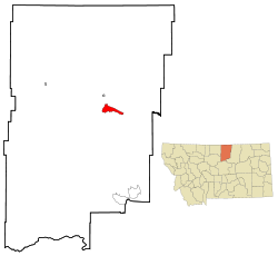
Blaine County Montana Incorporated and Unincorporated areas Fort Belknap Agency Highlighted.svg
Location of Fort Belknap Agency, Montana
Coordinates: 48°28′8″N108°45′19″W / 48.46889°N 108.75528°W / 48.46889; -108.75528
Country United States
State Montana
County Blaine
Area
[1]
  Total45.76 sq mi (118.52 km2)
  Land45.50 sq mi (117.85 km2)
  Water0.26 sq mi (0.66 km2)
Elevation
2,375 ft (724 m)
Population
 (2020)
  Total1,567
  Density34.44/sq mi (13.30/km2)
Time zone UTC-7 (Mountain (MST))
  Summer (DST) UTC-6 (MDT)
Area code 406
FIPS code 30-27850
GNIS feature ID0771503

Fort Belknap Agency is a census-designated place (CDP) in Blaine County, Montana, United States. As of the 2010 census, its population was 1,293. [2]

Contents

Fort Belknap Indian Reservation

Fort Belknap Agency is the capital of the Fort Belknap Indian Reservation. It is located at the northern end of the reservation at the junction of U.S. Route 2 and Montana Highway 66. The town is the home of Aaniiih Nakoda College, and other facilities such as the Fort Belknap Hospital, an office of the Bureau of Indian Affairs, the Fort Belknap Tribal Council and Tribal Police, and a highway rest area.

Geography

Fort Belknap Agency is located at 48°28′8″N108°45′19″W / 48.46889°N 108.75528°W / 48.46889; -108.75528 (48.468779, -108.755390). [3]

According to the United States Census Bureau, the CDP has a total area of 45.8 square miles (118.5 km2), of which 45.5 square miles (117.8 km2) are land and 0.27 square miles (0.7 km2), or 0.56%, is covered by water. [2]

Summer evening with approaching storm at Fort Belknap Agency. Photo by Lukas Eddy Fort Belknap Agency Lukas Eddy.jpg
Summer evening with approaching storm at Fort Belknap Agency. Photo by Lukas Eddy
Thunderstorms are common in the spring and summer. Photo by Lukas Eddy Fort Belknap Agency 2 Lukas Eddy.jpg
Thunderstorms are common in the spring and summer. Photo by Lukas Eddy

Demographics

Historical population
CensusPop.Note
2020 1,567
U.S. Decennial Census [4]

As of the census [5] of 2000, 1,262 people, 345 households, and 287 families were residing in the CDP. This grew to 1293 in the 2010 census and 1,567 in the 2020 census. The population density in 2000 was 116.4 people/sq mi (45.0/km2). The 380 housing units averaged 35.1/sq mi (13.5/km2). The racial makeup of the CDP was 2.61% White, 0.32% African American, 95.64% Native American, 0.08% Asian, 0.16% Pacific Islander, and 1.19% from two or more races. Hispanics or Latinos of any race were 1.51% of the population.

Of the 345 households, 50.7% had children under the age of 18 living with them, 40.9% were married couples living together, 32.8% had a female householder with no husband present, and 16.8% were not families. About 14.2% of all households were made up of individuals, and 3.2% had someone living alone who was 65 years of age or older. The average household size was 3.64, and the average family size was 4.00.

In the CDP, the age distribution was 41.8% under 18, 12.4% from 18 to 24, 25.2% from 25 to 44, 16.3% from 45 to 64, and 4.3% who were 65 or older. The median age was 22 years. For every 100 females, there were 90.6 males. For every 100 females age 18 and over, there were 88.9 males.

The median income for a household in the CDP was $22,000, and for a family was $23,583. Males had a median income of $26,364 versus $20,833 for females. The per capita income for the CDP was $9,053. About 37.9% of families and 38.3% of the population were below the poverty line, including 39.0% of those under age 18 and 56.1% of those age 65 or over.

Notable people

Related Research Articles

<span class="mw-page-title-main">Blaine County, Montana</span> County in Montana, United States

Blaine County is a county in the U.S. state of Montana. As of the 2020 census, the population was 7,044. Its county seat is Chinook. The county was named for James G. Blaine, former United States Secretary of State. It is on the north line of the state, and thus shares the southern border of Canada opposite Saskatchewan.

<span class="mw-page-title-main">Pryor, Montana</span> Census-designated place in Montana, United States

Pryor is a census-designated place (CDP) in Big Horn County, Montana, United States. The community is located on Crow Tribe's reservation. The population was 618 at the 2010 census. The area is named for Nathaniel Hale Pryor, a sergeant in the Lewis and Clark Expedition.

<span class="mw-page-title-main">Wyola, Montana</span> Census-designated place in Montana, United States

Wyola is a census-designated place (CDP) in Big Horn County, Montana, United States. The population was 215 at the 2010 census. 79% of the residents are Native American, and the majority are members of the Crow Nation.

<span class="mw-page-title-main">Hays, Montana</span> Census-designated place in Montana, United States

Hays is a census-designated place (CDP) in Blaine County, Montana, United States. The population was 843 at the 2010 census. The community lies within the Fort Belknap Indian Reservation, near the reservation's southern end. The nearby community of Lodge Pole lies to the east.

<span class="mw-page-title-main">Lodge Pole, Montana</span> Census-designated place in Montana, United States

Lodge Pole is a census-designated place (CDP) in Blaine County, Montana, United States. The population was 265 at the 2010 census. It lies within the Fort Belknap Indian Reservation, near the reservation's southern end.

<span class="mw-page-title-main">Fort Shaw, Montana</span> CDP in Montana, United States

Fort Shaw is a census-designated place (CDP) in Cascade County, Montana, United States. The population was 280 at the 2010 census. Named for a former United States military outpost, it is part of the Great Falls, Montana Metropolitan Statistical Area.

<span class="mw-page-title-main">Boneau, Montana</span> Census-designated place in Montana, United States

Boneau is a census-designated place (CDP) in Chouteau County, Montana, United States. The population was 380 at the 2010 census, up from 190 in 2000.

<span class="mw-page-title-main">Loma, Montana</span> Census-designated place in Montana, United States

Loma is a census-designated place (CDP) in Chouteau County, Montana, United States. The population was 85 at the 2010 census.

<span class="mw-page-title-main">Willow Creek, Montana</span> Census-designated place in Gallatin County, Montana, United States.

Willow Creek is a census-designated place (CDP) in Gallatin County, Montana, United States. The population was 210 at the 2010 census. It is part of the Bozeman, MT Micropolitan Statistical Area.

<span class="mw-page-title-main">Starr School, Montana</span> Census-designated place in Montana, United States

Starr School is a census-designated place (CDP) in Glacier County, Montana, United States. The population was 252 at the 2010 census.

<span class="mw-page-title-main">Rocky Boy's Agency, Montana</span> CDP in Montana, United States

Rocky Boy's Agency is a census-designated place (CDP) in Hill County, Montana, United States. The population was 355 at the 2010 census. The settlement developed around the US Indian agency for the Rocky Boy's Indian Reservation.

<span class="mw-page-title-main">Sangrey, Montana</span> Census-designated place in Montana, United States

Sangrey is a census-designated place (CDP) in Hill County, Montana, United States. The population was 306 at the 2010 census, up from 263 in 2000.

<span class="mw-page-title-main">St. Pierre, Montana</span> Census-designated place in Montana, United States

St. Pierre is a census-designated place (CDP) in Hill County, Montana, United States, within the Rocky Boy Indian Reservation. The population of St. Pierre was 350 at the 2010 census, up from 289 in 2000.

<span class="mw-page-title-main">Poplar, Montana</span> City in Montana, United States

Poplar is a city in Roosevelt County, Montana, United States. The population was 758 at the 2020 census.

<span class="mw-page-title-main">Birney, Montana</span> Census-designated place in Montana, United States

Birney is a census-designated place (CDP) in Rosebud County, Montana, United States. The population was 108 at the 2000 census.

<span class="mw-page-title-main">Reserve, Montana</span> CDP in Montana, United States

Reserve is a census-designated place (CDP) in Sheridan County, Montana, United States. The population was 23 at the 2010 census.

<span class="mw-page-title-main">Shepherd, Montana</span> CDP in Montana, United States

Shepherd is a census-designated place (CDP) in Yellowstone County, Montana, United States. The population was 193 at the 2000 census. Shepherd is a Billings suburb located to the northeast. The unincorporated town was named after R.E. Shepherd, a prominent early settler and owner of the Billings Land and Irrigation Company and the Merchants National Bank. The post office opened in 1915.

<span class="mw-page-title-main">Worden, Montana</span> CDP in Montana, United States

Worden is a census-designated place (CDP) in Yellowstone County, Montana, United States. The population was 506 at the 2000 census. Worden, along with Ballantine, Huntley, and Pompey's Pillar, is part of the Huntley Project, an irrigation district established by the United States Bureau of Reclamation in 1907.

McDougald Township is a township in Lake of the Woods County, Minnesota, United States. The population was 236 at the 2000 census.

<span class="mw-page-title-main">White Shield, North Dakota</span> CDP in North Dakota, United States

White Shield is a census-designated place (CDP) lying within the boundaries of the Mandan, Hidatsa, and Arikara Nation. It is located "on" the Fort Berthold Indian Reservation in McLean County, North Dakota, United States. The population was 336 at the 2010 census. It is considered the primary community of the Arikara (Sahnish) people and is named for Chief White Shield.

References

  1. "ArcGIS REST Services Directory". United States Census Bureau. Retrieved September 5, 2022.
  2. 1 2 "Geographic Identifiers: 2010 Demographic Profile Data (G001): Fort Belknap Agency CDP, Montana". U.S. Census Bureau, American Factfinder. Archived from the original on February 12, 2020. Retrieved June 25, 2013.
  3. "US Gazetteer files: 2010, 2000, and 1990". United States Census Bureau. February 12, 2011. Retrieved April 23, 2011.
  4. "Census of Population and Housing". Census.gov. Retrieved June 4, 2016.
  5. "U.S. Census website". United States Census Bureau . Retrieved January 31, 2008.