Related Research Articles

Montana is a landlocked state in the Mountain West subregion of the Western United States. It borders Idaho to the west, North Dakota to the east, South Dakota to the southeast, Wyoming to the south, and the Canadian provinces of Alberta, British Columbia, and Saskatchewan to the north. It is the fourth-largest state by area, but the eighth-least populous state and the third-least densely populated state. Its capital is Helena, while the most populous city is Billings. The western half of the state contains numerous mountain ranges, while the eastern half is characterized by western prairie terrain and badlands, with smaller mountain ranges found throughout the state.
Beaverhead County is the largest county by area in the U.S. state of Montana. As of the 2020 census, the population was 9,371. Its county seat is Dillon. The county was founded in 1865.
Georgetown is the territorial charter municipality that is the county seat of Clear Creek County, Colorado, United States. The town population was 1,118 at the 2020 United States Census. The former silver mining camp along Clear Creek in the Front Range of the Rocky Mountains was established in 1859 during the Pike's Peak Gold Rush. The federally designated Georgetown-Silver Plume Historic District comprises Georgetown, the neighboring town of Silver Plume, and the Georgetown Loop Historic Mining & Railroad Park between the two towns. The Georgetown Post Office has the ZIP code 80444.

Leadore is an incorporated small town in Lemhi County, Idaho, United States. The population was 105 at the 2010 census.
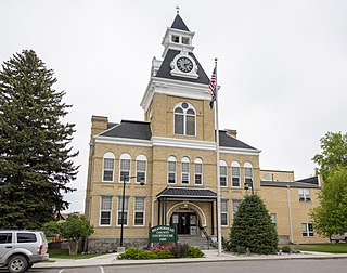
Dillon is a city in and the county seat of Beaverhead County, Montana, United States. The population was 3,880 at the 2020 census. The city was named for Sidney Dillon (1812–1892), president of Union Pacific Railroad.

Whitefish is a city in Flathead County, Montana, United States. According to the 2020 United States Census, there were 7,751 people in the city.

Whitehall is a town in Jefferson County, Montana, United States. The population was 1,006 at the 2020 census. It is part of the Helena Micropolitan Statistical Area.

Bonner-West Riverside is a census-designated place (CDP) in Missoula County, Montana, United States, including the unincorporated communities of Bonner, Milltown, West Riverside, and Pinegrove. It is part of the Missoula metropolitan area. The population was 1,690 at the 2020 census.

The Bitterroot Range is a mountain range and a subrange of the Rocky Mountains that runs along the border of Montana and Idaho in the northwestern United States. The range spans an area of 24,223 square miles (62,740 km2) and is named after the bitterroot, a small pink flower that is the state flower of Montana.
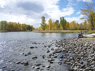
The Big Hole River is a tributary of the Jefferson River, approximately 153 miles (246 km) long, in Beaverhead County, in southwestern Montana, United States. It is the last habitat in the contiguous United States for native fluvial Arctic grayling and is a historically popular destination for fly fishing, especially for trout.

The Beaverhead–Deerlodge National Forest is the largest of the National Forests in Montana, United States. Covering 3.36 million acres (13,600 km2), the forest is broken into nine separate sections and stretches across eight counties in the southwestern area of the state. President Theodore Roosevelt named the two forests in 1908 and they were merged in 1996. Forest headquarters are located in Dillon, Montana. In Roosevelt's original legislation, the Deerlodge National Forest was called the Big Hole Forest Reserve. He created this reserve because the Anaconda Copper Mining Company, based in Butte, Montana, had begun to clearcut the upper Big Hole River watershed. The subsequent erosion, exacerbated by smoke pollution from the Anaconda smelter, was devastating the region. Ranchers and conservationists alike complained to Roosevelt, who made several trips to the area. (Munday 2001)
Moyers is an unincorporated community located in Pushmataha County, Oklahoma, United States.

The Anaconda Range, informally known as the "Pintlers", is a group of high mountains located in southwestern Montana, in the northwestern United States. The mountain range takes its name from the nearby town of Anaconda, founded by Marcus Daly in 1883. It runs northeast approximately 50 miles (80 km) from Lost Trail Pass to a point near the community of Anaconda, covering parts of Ravalli, Deer Lodge, Granite and Beaverhead Counties. To the northwest are the Sapphire Mountains, to the south is the Big Hole Valley. Due north, the range blends into the Flint Creek Range, and to the southeast lies the Big Hole River and Pioneer Mountains. The crest of the range is part of the Continental Divide, rising to 10,793 feet (3,290 m) at West Goat Peak. Other major summits include Mt. Evans, Mt. Haggin, Warren Peak, and East Goat Peak. West Pintler Peak, located in a more commonly visited area, rises to 9,894 feet (3,016 m). Much of the range is protected in the Anaconda-Pintler Wilderness Area.
Wise River is an unincorporated small village in northern Beaverhead County, Montana, United States. The village runs along State Highway 43, in three sections, for about a mile. There is a small store with gas pump there, also a post office and a club lodge, along with several homes.

Montana is one of the eight Mountain States, located in the north of the region known as the Western United States. It borders North Dakota and South Dakota to the east. Wyoming is to the south, Idaho is to the west and southwest, and the Canadian provinces of British Columbia, Alberta, and Saskatchewan are to the north, making it the only state to border three Canadian provinces.

The Selected Works of T.S. Spivet is the debut novel by American author Reif Larsen, first published in 2009. The book follows the exploits of a 12-year-old mapmaker named T.S. Spivet, who lives on a ranch near Divide, Montana, as he receives a prestigious award and accepts it, hitch-hiking on a freight train for the acceptance speech in Washington D.C.. The book is noteworthy for its unique design; the plot-line is illustrated with images which further the narrative by providing charts, lists, sketches, and maps accompanying each page, mirroring T.S.'s cartographic interests and his minute attention to detail.

The Beaverhead Mountains, highest point Scott Peak, el. 11,393 feet (3,473 m), are a mountain range straddling the Continental Divide in the U.S. states of Montana and Idaho. They are a sub-range of the Bitterroot Range, and divide Beaverhead County, Montana from Lemhi County, Idaho and Clark County, Idaho.
The Montana valley and foothill grasslands are an ecoregion of northwestern North America in the northern United States and southern Canada.
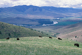
The Regional designations of Montana vary widely within the U.S state of Montana. The state is a large geographical area that is split by the Continental Divide, resulting in watersheds draining into the Pacific Ocean, Gulf of Mexico and Hudson's Bay. The state is approximately 545 miles (877 km) east to west along the Canada–United States border and 320 miles (510 km) north to south. The fourth largest state in land area, it has been divided up in official and unofficial ways into a variety of regions. Additionally, Montana is part of a number of larger federal government administrative regions.
Sula is a census-designated place (CDP) in Ravalli County, Montana, United States. It is named after the community of Sula, which it encompasses, and was established about 2010, prior to that year's census. The population of the CDP was 37 at the 2010 census.
References
- ↑ "Divide, Montana". Geographic Names Information System . United States Geological Survey, United States Department of the Interior.
- ↑ Moyer, Armond; Moyer, Winifred (1958). The origins of unusual place-names. Keystone Pub. Associates. p. 36.
- ↑ "ZIP Code 59727", U.S. Census website, United States Census Bureau
- ↑ Climate Summary for Divide, Montana
- ↑ "Divide, Montana 1991–2020 Monthly Normals" . Retrieved December 3, 2023.
- ↑ "xmACIS". National Oceanic and Atmospheric Administration. Retrieved December 3, 2023.
- ↑ Fran Arrieta-Walden, "Review: The Selected Works of T.S. Spivet" Oregon Books
- "Divide", Montana Official Travel Site [ permanent dead link ]
- Cheney's Names on the Face of Montana, Mountain Press Publishing Company
Municipalities and communities of Silver Bow County, Montana, United States | ||
|---|---|---|
| City |  | |
| Town | ||
| Unincorporated communities | ||
| Ghost town | ||
| Neighborhoods | ||
| Footnotes | ‡This populated place also has portions in an adjacent county or counties | |
45°45′04″N112°44′47″W / 45.75111°N 112.74639°W
| | This Silver Bow County, Montana state location article is a stub. You can help Wikipedia by expanding it. |