Big Hole River

Last updated • 6 min readFrom Wikipedia, The Free Encyclopedia
Big Hole River
BigHoleRiverNearTwinBridges.jpg
Big Hole River near Twin Bridges, Montana
Big Hole River Watershed.png
Map of the Big Hole River watershed
USA Montana relief location map.jpg
Red pog.svg
Location of mouth
Native nameSk͏ʷumcné Sewɫk͏ʷs
Location
CountryUnited States
StateMontana
Physical characteristics
Source 
  locationSkinner Lake, Bitterroot Range, Montana, Beaverhead
  coordinates 45°10′22″N113°30′42″W / 45.17278°N 113.51167°W / 45.17278; -113.51167 [1]
  elevation7,372 ft (2,247 m) [2]
Mouth Jefferson River
  location
Twin Bridges, Montana
  coordinates
45°34′04″N112°20′21″W / 45.56778°N 112.33917°W / 45.56778; -112.33917 [1]
  elevation
4,610 ft (1,410 m) [1]
Length153 mi (246 km)
Basin size2,800 sq mi (7,300 km2)
Discharge 
  locationnear Twin Bridges
  average1,250 cu ft/s (35 m3/s) [3]
Basin features
Tributaries 
  right Wise River
Montana rivers with the Big Hole in the southwest Mt-rivers.gif
Montana rivers with the Big Hole in the southwest
Big Hole River Watershed Map BigHoleRiverWatershedFWS.jpg
Big Hole River Watershed Map
Upper Big Hole River near Jackson, Montana BigHoleRiverHeadwaters.jpg
Upper Big Hole River near Jackson, Montana

The Big Hole River is a tributary of the Jefferson River, approximately 153 miles (246 km) long, in Beaverhead County, in southwestern Montana, United States. It is the last habitat in the contiguous United States for native fluvial Arctic grayling [4] and is a historically popular destination for fly fishing, especially for trout.

Contents

History

At the time the Lewis and Clark Expedition traveled through the Big Hole River watershed, it was a buffer zone between several rival Native American tribes including the Nez Percé, Shoshone, Coast Salish, and Blackfeet. Lewis and Clark considered navigating up the Big Hole River, but chose the slower-flowing Beaverhead River instead. Trappers from both the Hudson's Bay Company, the North West Company and the American Fur Company exploited the region from about 1810 to the 1840s. Miners and homesteaders settled the area between 1864 and the early 1900s.[ citation needed ] The Montana Salish called the river Sk͏ʷumcné Sewɫk͏ʷs, meaning "waters of the pocket gopher". [5]

In 1877 the U.S. troops under John Gibbon fought the Nez Percé Indians along the Big Hole River, during the Nez Perce War in the Battle of the Big Hole. The site of the battle along the North fork of the Big Hole is preserved as the Big Hole National Battlefield. [6]

The establishment of Butte, Montana as a mining center and the coming of the Northern Railroad in 1871 assured Big Hole ranchers and farmers of a steady market for their beef, horses, mules, hay and dairy products. Ranches grew along the river from railroad supply points such as Divide, Montana. [7] As a great improvement for preserving the wild hay for winter feeding of cattle, Herbert S. Armitage and David J. Stephens filed for a "Hay-Stacker" patent in 1909, which was awarded in 1910. This device, commonly known as a "beaverslide" remained popular until the 1990s, when it was largely displaced by mechanized equipment for producing large round bales. [8] [9] [10]

Watershed and course

The Big Hole River watershed drains 2,800 sq mi (7,300 km2). [11] [12]

The source of the mainstem Big Hole River is Skinner Lake in the Beaverhead National Forest in the Beaverhead Mountains of the Bitterroot Range at the Continental Divide along the Montana-Idaho border in western Beaverhead County. However, Skinner Lake is in turn fed by Darkhorse Creek, which flows from Darkhorse and Cowbone Lakes, the former at 8,691 feet (2,649 m). [13] The Big Hole River flows northwest and north, past Wisdom and between the Anaconda Range to the northwest and the Pioneer Mountains to the east.

Drone Shot of the Big Hole River [14]

It flows around the north end of the Pioneers where it forms the border between Beaverhead County and Deer Lodge County and then Silver Bow County, then southeast past the town of Wise River, Montana, where it is joined by the Wise River. Near Glen, Montana it turns northeast and joins the Beaverhead River near Twin Bridges to form the Jefferson River, [15] a tributary of the Missouri.

Ecology and conservation

Historic conflicts exist between ranchers in the valley who use the river for irrigation and recreationalists. In the early 1960s, the US Bureau of Reclamation proposed building the Reichle Dam near the town of Glen along the Big Hole River. Conservationist George F. Grant, Trout Unlimited and local ranchers combined forces to oppose the dam, successfully defeating the proposal in 1967. [16]

Grayling

The Big Hole is the last habitat in the contiguous United States for native fluvial (river-dwelling) Arctic grayling (Thymallis arcticus). Fluvial Arctic grayling lived historically in the United States only in Michigan and the upper Missouri River above Great Falls, Montana. Adfluvial or lake-dwelling Arctic grayling, still thrive across the western half of Montana. The fluvial population comprises the Upper Missouri River distinct population segment (DPS) population. The two populations are commonly called Montana Arctic grayling. [4] The Big Hole River Watershed Committee (BHWC) was formed in 1995 by several Big Hole ranchers and some factions of the conservation community who opposed an ESA listing for fluvial Arctic grayling. The Watershed Committee reached out to local and selected interested entities and developed a viable community-based consensus group to forge solutions to difficult problems that impact the river. The committee was criticized for exclusion of activist voices such as the Center for Biological Diversity and the Montana Wildlife Federation. In response, organizations such as the Big Hole River Foundation were formed, with the goal "to understand, preserve, and enhance the free flowing character of the Big Hole River and to protect its watershed, culture, community and excellent wild trout fishery." [17]

After years of debate by all interests in the Big Hole watershed, in April 2007, the U.S. Fish and Wildlife Service (USFWS) removed the fluvial Arctic Grayling from Endangered Species candidacy, which has resulted in a lawsuit by the Center for Biological Diversity and other interested parties, [18] who have stated the view that the USFWS decision was politically mandated by Julie MacDonald, the former Department of Interior official who has since resigned. An Office of the Inspector General investigation found that "MacDonald has been heavily involved with editing, commenting on, and reshaping the Endangered Species Program's scientific reports." In the case of grayling, MacDonald ignored clear genetic differences between extremely rare fluvial (river) grayling and relatively common lacustrine (lake) grayling. [19] In 2014, The USFWS again affirmed that local conservation efforts are sufficient to protect the grayling, and declined to list the DPS of the grayling as federally endangered. [4]

An environmental DNA assay using tissue samples from grayling in the Bighole River can identify grayling with high specificity against other native and non-native salmonids in Montana. [20]

Angling the Big Hole

The Big Hole river has been a destination for trout fisherman since the late 1880s when The Angler's Guide, an Eastern angling journal advertised the Big Hole as a national destination fishery for grayling and trout while promising daily 40 lb (18 kg) catches. [21] Although the river still holds some native westslope cutthroat trout, their populations are almost non-existent. Instead, the river holds healthy wild populations of brook, rainbow and brown trout which were first introduced into the Big Hole in late 1880s as hatchery operations began in Butte and Bozeman, Montana. Native mountain whitefish are also prevalent in the river. In the 1980s, the state of Montana began stopping general stocking of all Montana rivers. The last hatchery fish were stocked in the Big Hole in 1990. [22] Dozens of guides, outfitters and fishing lodges offer guided fishing on the Big Hole and its tributaries.[ citation needed ] The river is catch and release for brown trout (Dickey bridge to mouth) [23]

The river is a Class I water from the Fishtrap fishing access site downstream from Wisdom to its confluence with the Jefferson River. This status affects the level of public access for recreational purposes. [24]

Sections of the Big Hole, [25] [26]
SectionDescriptionPrevalent Species
Skinner Lake (Headwaters), Wisdom, MT to Fish Trap (River Mile 81)This is the slow moving, high meadow stretch of the Big Hole. It ends at the last public access site on the river: Fish Trap.The meadow stretch is home to a few remaining native Fluvial Arctic Grayling and a good population of exotic Brook trout. Rainbows and browns are few in this section.
Fish Trap to MelroseThis section is characterized by bouldered pocket water as it flows through a narrow canyon. This is excellent stone fly water. This section has 5 public access sites: Sportsman Park (Mile 78), Dewey (Mile 57), Greenwood Bottoms (Mile 57), Powerhouse (Mile 52) and Maidenrock (Mile 48).Rainbows dominate brown trout in this stretch 2:1 with approximately 3000 fish per mile.
Melrose to Twin Bridges, MTThis section is characterized by cottonwood bottoms with braided channels and long, slow pools. This is also excellent stone fly water. There are public access sites at Salmon Fly (Mile 38), Brownes Bridge (Mile 32), Kalsta Bridge (Mile 30), Glen (Mile 25), Notch Bottom (Mile 18), Pennington Bridge (Mile 9), High Road (Mile 2).Browns dominate rainbow trout in this stretch 2:1 with approximately 3000 fish per mile.

See also

Notes

  1. 1 2 3 U.S. Geological Survey Geographic Names Information System: Big Hole River
  2. "Skinner Lake". Geographic Names Information System . United States Geological Survey, United States Department of the Interior.
  3. "USGS Surface Water data for Montana: USGS Surface-Water Annual Statistics".
  4. 1 2 3 "Arctic Grayling - Endangered Species of the Mountain-Prairie Region". U. S. Fish and Wildlife Service. Retrieved 2014-10-26.
  5. "Salish Audio Files". Salish-Pend d'Oreille Culture Committee. 2014. Retrieved 2014-06-28.
  6. Greene, Jerome A. (2000). Nez Perce Summer, 1877-The U.S. Army and the Nee-Me-Poo Crisis. Helena, MT: Montana Historical Society Press. ISBN   0-917298-68-3.
  7. "Divide", Montana Official Travel Site
  8. Munday, Pat (2001). "6". Montana's Last Best River: The Big Hole and Its People. Guilford, CT: The Lyons Press. p. 75. ISBN   978-1-585-74331-5.
  9. Welsch, Jeff; Moore, Sherry (2011). Backroads & Byways of Montana: Drives, Day Trips & Weekend Excursions. Woodstock, VT: The Countryman Press. pp. 96–99. ISBN   978-0-88150-899-4.
  10. USPatent 959906,Herbert S. Armitage&David J. Stephens,"Hay-Stacker",issued May 31, 1910 U.S. patent 959,906
  11. Big Hole Watershed Committee (2012-11-01). Big Hole River Watershed, Montana Watershed Restoration Plan - Upper and North Fork Watershed (PDF) (Report). Retrieved 2014-10-26.
  12. Big Hole Watershed Committee (2013-08-29). Big Hole River, Montana Watershed Restoration Plan - Middle and Lower Watershed (PDF) (Report). Retrieved 2014-10-26.
  13. "Darkhorse Creek". Geographic Names Information System . United States Geological Survey, United States Department of the Interior.
  14. McLean, Bryce. "Drone Shot of the Big Hole River". guide-x.io. Archived from the original on 2021-05-06. Retrieved 2021-05-06.
  15. "Big Hole River". Big Sky Fishing.com. February 2022.
  16. "Big Hole River Drainage" (PDF). fwp.mt.gov.
  17. The Big Hole River Foundation Website
  18. CBD Press Release
  19. "Who Needs Grayling? - Ted Williams - October 2007 - national". Archived from the original on 2008-08-07. Retrieved 2008-12-16.
  20. K. J. Carim; J. C. S. Dysthe; M. K. Young; K. S. McKelvey; M. K. Schwartz (2016). "An environmental DNA assay for detecting Arctic grayling in the upper Missouri River basin, North America" (PDF). Conservation Genetics Resources. 8 (3): 197–199. Bibcode:2016ConGR...8..197C. doi:10.1007/s12686-016-0531-1. S2CID   15080684 . Retrieved June 17, 2021.
  21. Munday, Pat (2001). Montana's Last Best River: The Big Hole & its People. Guilford, CT: Lyons Press. p. 100. ISBN   1-58574-331-3.
  22. Munday, Pat (2001). Montana's Last Best River: The Big Hole & its People. Guilford, CT: Lyons Press. p. 108. ISBN   1-58574-331-3.
  23. "New Brown Trout Regulations in-place on Big Hole Beaverhead rivers". Montana Fish Wildlife and Parks. Retrieved December 29, 2021.
  24. Stream Access in Montana Archived 2009-03-10 at the Wayback Machine
  25. Munday, Pat (2001). Montana's Last Best River: The Big Hole & its People. Guilford, CT: Lyons Press. pp. 133–136. ISBN   1-58574-331-3.
  26. Montana Fish, Wildlife and Parks - Big Hole River

Related Research Articles

<span class="mw-page-title-main">Nez Perce</span> Indigenous peoples of North America

The Nez Perce are an Indigenous people of the Plateau who still live on a fraction of the lands on the southeastern Columbia River Plateau in the Pacific Northwest. This region has been occupied for at least 11,500 years.

<span class="mw-page-title-main">Twin Bridges, Montana</span> Town in Montana, United States

Twin Bridges is a town in Madison County, Montana, United States. It lies at the confluence of the Ruby, Beaverhead and Big Hole rivers which form the Jefferson River. Twin Bridges is a well-known fly fishing mecca for trout anglers. The population was 330 at the 2020 census.

<span class="mw-page-title-main">Madison River</span> River in Wyoming and Montana, United States

The Madison River is a headwater tributary of the Missouri River, approximately 183 miles (295 km) long, in Wyoming and Montana. Its confluence with the Jefferson and Gallatin rivers near Three Forks, Montana forms the Missouri River.

<span class="mw-page-title-main">Ruby River</span> Tributary of the Beaverhead River

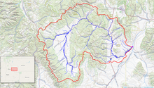
The Ruby River is a tributary of the Beaverhead River, approximately 76 mi (122 km) long, in southwestern Montana in the United States. It rises in the Beaverhead National Forest in southwestern Madison County between the Snowcrest Range and the Gravelly Range. It flows north through the Ruby River Reservoir, past Alder, then northwest, flowing between the Tobacco Root Mountains to the northeast and the Ruby Range to the southwest. It joins the Beaverhead near Twin Bridges. The Beaverhead becomes the Jefferson River 2 mi (3.2 km) downstream where it joins the Big Hole River.

<span class="mw-page-title-main">East Gallatin River</span> River in Montana, United States

The East Gallatin River flows 42 miles (68 km) in a northwesterly direction through the Gallatin valley, Gallatin County, Montana. Rising from the confluence of Rocky Creek and several other small streams, the East Gallatin begins about one mile (1.6 km) east of downtown Bozeman, Montana. The river joins the main stem of the Gallatin River 2.3 miles (3.7 km) north of Manhattan, Montana. Throughout its course, the river traverses mostly valley floor ranch and farm land with typical summer flows of approximately 50 cu ft/s (1.4 m3/s).

<span class="mw-page-title-main">Lolo Pass (Idaho–Montana)</span> United States historic place

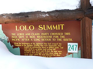
Lolo Pass, elevation 5,233 feet (1,595 m), is a mountain pass in the western United States, in the Bitterroot Range of the northern Rocky Mountains. It is on the border between the states of Montana and Idaho, approximately forty miles (65 km) west-southwest of Missoula, Montana.

<span class="mw-page-title-main">Nez Perce National Historical Park</span> Series of federally protected historic sites in the northwestern United States

The Nez Perce National Historical Park is a United States National Historical Park comprising 38 sites located across the states of Idaho, Montana, Oregon, and Washington, which include traditional aboriginal lands of the Nez Perce people. The sites are strongly associated with the resistance of Chief Joseph and his band, who in June 1877 migrated from Oregon in an attempt to reach freedom in Canada and avoid being forced on to a reservation. They were pursued by U.S. Army cavalry forces and fought numerous skirmishes against them during the so-called Nez Perce War, which eventually ended with Chief Joseph's surrender in the Montana Territory.

<span class="mw-page-title-main">Arctic grayling</span> Species of fish

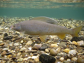
The Arctic grayling is a species of freshwater fish in the salmon family Salmonidae. T. arcticus is widespread throughout the Arctic and Pacific drainages in Canada, Alaska, and Siberia, as well as the upper Missouri River drainage in Montana. In the U.S. state of Arizona, an introduced population is found in the Lee Valley and other lakes in the White Mountains. They were also stocked at Toppings Lake by the Teton Range and in lakes in the high Uinta Mountains in Utah, as well as alpine lakes of the Boulder Mountains (Idaho) in central Idaho.

<span class="mw-page-title-main">Battle of the Big Hole</span> 1877 battle of the Nez Perce War

The Battle of the Big Hole was fought in Montana Territory, August 9–10, 1877, between the United States Army and the Nez Perce tribe of Native Americans during the Nez Perce War. Both sides suffered heavy casualties. The Nez Perce withdrew in good order from the battlefield and continued their long fighting retreat that would result in their attempt to reach Canada and asylum.

<span class="mw-page-title-main">Big Hole National Battlefield</span> Historical battlefield in Montana, United States

Big Hole National Battlefield preserves a battlefield in the western United States, located in Beaverhead County, Montana. In 1877, the Nez Perce fought a delaying action against the U.S. Army's 7th Infantry Regiment here on August 9 and 10, during their failed attempt to escape to Canada. This action, the Battle of the Big Hole, was the largest battle fought between the Nez Perce and U.S. Government forces in the five-month conflict known as the Nez Perce War.

<span class="mw-page-title-main">Beaverhead–Deerlodge National Forest</span> National Forests in Montana, United States

The Beaverhead–Deerlodge National Forest is the largest of the National Forests in Montana, United States. Covering 3.36 million acres (13,600 km2), the forest is broken into nine separate sections and stretches across eight counties in the southwestern area of the state. President Theodore Roosevelt named the two forests in 1908 and they were merged in 1996. Forest headquarters are located in Dillon, Montana. In Roosevelt's original legislation, the Deerlodge National Forest was called the Big Hole Forest Reserve. He created this reserve because the Anaconda Copper Mining Company, based in Butte, Montana, had begun to clearcut the upper Big Hole River watershed. The subsequent erosion, exacerbated by smoke pollution from the Anaconda smelter, was devastating the region. Ranchers and conservationists alike complained to Roosevelt, who made several trips to the area. (Munday 2001)

<span class="mw-page-title-main">Firehole River</span> River in Wyoming, United States

The Firehole River is located in northwestern Wyoming, and is one of the two major tributaries of the Madison River. It flows north approximately 21 miles (34 km) from its source in Madison Lake on the Continental Divide to join the Gibbon River at Madison Junction in Yellowstone National Park. It is part of the Missouri River system.

<span class="mw-page-title-main">Manistee River</span> River in Michigan, United States

The Manistee River is a 190-mile-long (310 km) river in the Lower Peninsula of the U.S. state of Michigan. The river rises in the Northern Lower Peninsula, and flows in a generally southwesterly direction to its mouth at Lake Michigan at the eponymous city of Manistee.

Pat Munday is an American environmentalist, writer, and college professor living in Butte, Montana. He was awarded the Liebig-Woehler Freundschaft Prize for scholarship in the history of chemistry, and contributions through environmental activism.

<span class="mw-page-title-main">Gibbon River</span> River in Wyoming, United States

The Gibbon River flows east of the Continental Divide in Yellowstone National Park, in northwestern Wyoming, the Northwestern United States. Along with the Firehole River, it is a major tributary of the Madison River, which itself is a tributary of the Missouri River.

<span class="mw-page-title-main">Angling in Yellowstone National Park</span>

Angling in Yellowstone National Park is a major reason many visitors come to the park each year and since it was created in 1872, the park has drawn anglers from around the world to fish its waters. In 2006, over 50,000 park fishing permits were issued to visitors. The park contains hundreds of miles of accessible, high-quality trout rivers containing wild trout populations—over 200 creeks, streams and rivers are fishable. There are 45 fishable lakes and several large lakes are easily accessible to visitors. Additionally, the park's remote sections provide anglers ample opportunity to visit rivers, streams, creeks and lakes that receive little angling pressure. With the exception of one specially designated drainage, all the park's waters are restricted to artificial lures and fly fishing. The Madison, Firehole and a section of the Gibbon rivers are restricted to fly fishing only.

<span class="mw-page-title-main">Grebe Lake</span> Lake in the American state of Wyoming

Grebe Lake is a 156 acres (0.63 km2) backcountry lake in Yellowstone National Park most noted for its population of Arctic grayling. Grebe Lake comprises the headwaters of the Gibbon River. Grebe Lake is located approximately 3.1 miles (5.0 km) north of the Norris-Canyon section of the Grand Loop Road. The trail to the lake passes through mostly level Lodgepole Pine forest and open meadows. The lake was named by J.P. Iddings, a geologist with the Arnold Hague geologic surveys. There are four backcountry campsites located on the lake.

<span class="mw-page-title-main">Beaverslide</span> Device for stacking hay

A beaverslide is a device for stacking hay, made of wooden poles and planks, that builds haystacks of loose, unbaled hay to be stored outdoors and used as fodder for livestock. The beaverslide consists of a frame supporting an inclined plane up which a load of hay is pushed to a height of about 30 feet (9 m), before dropping through a large gap. The resulting loaf-shaped haystacks can be up to 30 feet high, can weigh up to 20 tons, and can theoretically last up to five or six years. It was invented in the early 1900s and was first called the Beaverhead County Slide Stacker after its place of origin, the Big Hole Valley in Beaverhead County, Montana. The name was quickly shortened to "beaverslide."

<span class="mw-page-title-main">Montana Arctic grayling</span> Subspecies of fish

The Montana Arctic grayling is a North American freshwater fish in the salmon family Salmonidae. The Montana Arctic grayling, native to the upper Missouri River basin in Montana and Wyoming, is a disjunct population or subspecies of the more widespread Arctic grayling. It occurs in fluvial and adfluvial, lacustrine forms. The Montana grayling is a species of special concern in Montana and had candidate status for listing under the national Endangered Species Act. It underwent a comprehensive status review by the U.S. Fish and Wildlife Service, which in 2014 decided not to list it as threatened or endangered. Current surviving native populations in the Big Hole River and Red Rock River drainages represent approximately four percent of the subspecies' historical range.

References