Pat Munday is an American environmentalist, writer, and college professor living in Butte, Montana. He was awarded the Liebig-Woehler Freundschaft Prize for scholarship in the history of chemistry, and contributions through environmental activism.
Pat Munday is an American environmentalist, writer, and college professor living in Butte, Montana. He was awarded the Liebig-Woehler Freundschaft Prize for scholarship in the history of chemistry, and contributions through environmental activism.
This section of a biography of a living person does not include any references or sources .(November 2014) |
Munday graduated from Drexel University in 1978 with a double BS in Engineering and Humanities. He went on to study at the Rensselaer Polytechnic Institute and graduated in 1981 with an MS in Science, Technology and Values. He received his Cornell University his MA in History in 1987. In 1987 and 1988 he was a visiting researcher and Fulbright Scholar at the Universität Hamburg, Institut für Geschichte der Naturwissenschaften, Mathematik und Technik. After that Munday went on to receive his PhD from Cornell in the History and Philosophy of Science and Technology in 1990, where his dissertation was titled Sturm und Dung: Justus von Liebig (1803-73) and the chemistry of agriculture.
After graduating from Cornell Munday took a teaching position with Montana Tech of The University of Montana where he teaches courses on technology and society; professional ethics; the politics of technical decisions; and culture, technology & communication. He is a member of the Big Hole River Foundation and the George Grant chapter of Montana Trout Unlimited.
As President of the George Grant Chapter of Trout Unlimited, the group received more than $1 million in funding for a restoration & land acquisition project on German Gulch, a trout fishery near Butte.
He was a charter member and governor's appointee to Montana's Upper Clark Fork River Basin Remediation and Restoration Advisory Council from 1998–2002. The Council advises the Governor of Montana and works to promote public involvement, educational activities, and develop policy involving the State of Montana’s $215 million settlement for damages to natural resources caused by a century of mining and smelting activities. Munday helped establish the Council's newsletter and school resources, an effort that culminated in the establishment of the Clark Fork Watershed Education Program, hosted by Montana Tech of the University of Montana.
Munday delivers radio commentaries on KUFM (FM) for the Clark Fork River Technical Assistance Committee, an EPA Technical Advisory Committee for the Clark Fork River Superfund process. [1]
He was the Big Hole River Foundation's representative in the Big Hole River Conflict Resolution Committee, a state-appointed committee to resolve recreational conflicts through deliberative dialogue and policy suggestions to the state. Following a collapse of the state-appointed committee, a group led by Munday created a plan that was accepted by the state; the Seven Day Rest-Rotation Rule aimed to minimize conflict between the angling public and outfitters and guides. [2]
As the Big Hole River Foundation's interim Executive Director, the group received Resources for Community Collaboration/William & Flora Hewlett Foundation to inaugurate land use planning in the four counties governing land along the Big Hole River. This effort culminated in a four-county plan designed to better manage riverine habitat. [3]
Munday is the author of Montana's Last Best River: The Big Hole and its People. (Lyons Press, 2001, ISBN 978-1585743315), currently the only published work on this 2,800-square-mile (7,300 km2) watershed.. He published related articles including "George Grant and the Conservation of the Big Hole River Watershed"
Munday's earlier publications stemmed from his PhD thesis, "Sturm und Dung: Justus von Liebig (1803-73) and the Chemistry of Agriculture," completed under the direction of his Doktorvater Dr. L. Pearce Williams of Cornell University's Science & Technology Studies program. This early series of publications included "Social Climbing Through Chemistry: Justus von Liebig's Rise from the niederer Mittelstand to the Bildungsbuergertum, Ambix 37 (1990): 1-19 and "Politics by other means: Justus von Liebig and the German translation of John Stuart Mill's Logic", British Journal for the History of Science 31 (1998): 403-18. Munday's work on Liebig was cited heavily in the Liebig biography by University of Leicester professor William H. Brock, Justus von Liebig: The Chemical Gatekeeper (Cambridge University Press, 1997).
Munday's work on Liebig resulted in his being awarded the inaugural Liebig-Woehler Freundschaft Preis in 1994, which he shared with Dr. Emily Heuser. [4]

Justus Freiherr von Liebig was a German scientist who made major contributions to the theory, practice, and pedagogy of chemistry, as well as to agricultural and biological chemistry; he is considered one of the principal founders of organic chemistry. As a professor at the University of Giessen, he devised the modern laboratory-oriented teaching method, and for such innovations, he is regarded as one of the most outstanding chemistry teachers of all time. He has been described as the "father of the fertilizer industry" for his emphasis on nitrogen and minerals as essential plant nutrients, and his popularization of the law of the minimum, which states that plant growth is limited by the scarcest nutrient resource, rather than the total amount of resources available. He also developed a manufacturing process for beef extracts, and with his consent a company, called Liebig Extract of Meat Company, was founded to exploit the concept; it later introduced the Oxo brand beef bouillon cube. He popularized an earlier invention for condensing vapors, which came to be known as the Liebig condenser.

Butte is a consolidated city-county and the county seat of Silver Bow County, Montana, United States. In 1977, the city and county governments consolidated to form the sole entity of Butte-Silver Bow. The city covers 718 square miles (1,860 km2), and, according to the 2020 census, has a population of 34,494, making it Montana's fifth-largest city. It is served by Bert Mooney Airport with airport code BTM.

The Yellowstone River is a tributary of the Missouri River, approximately 671 miles (1,080 km) long, in the Western United States. Considered the principal tributary of upper Missouri, via its own tributaries it drains an area with headwaters across the mountains and high plains of southern Montana and northern Wyoming, and stretching east from the Rocky Mountains in the vicinity of Yellowstone National Park. It flows northeast to its confluence with the Missouri River on the North Dakota side of the border, about 25 miles (40 km) west of Williston.
The Jefferson River is a tributary of the Missouri River, approximately 83 miles (134 km) long, in the U.S. state of Montana. The Jefferson River and the Madison River form the official beginning of the Missouri at Missouri Headwaters State Park near Three Forks. It is joined 0.6 miles (1.0 km) downstream (northeast) by the Gallatin.
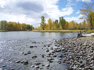
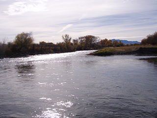
The Big Hole River is a tributary of the Jefferson River, approximately 153 miles (246 km) long, in Beaverhead County, in southwestern Montana, United States. It is the last habitat in the contiguous United States for native fluvial Arctic grayling and is a historically popular destination for fly fishing, especially for trout.

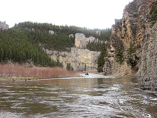
The Clark Fork, or the Clark Fork of the Columbia River, is a river in the U.S. states of Montana and Idaho, approximately 310 miles (500 km) long. It is named after William Clark of the 1806 Lewis and Clark Expedition. The largest river by volume in Montana, it drains an extensive region of the Rocky Mountains in western Montana and northern Idaho in the watershed of the Columbia River. The river flows northwest through a long valley at the base of the Cabinet Mountains and empties into Lake Pend Oreille in the Idaho Panhandle. The Pend Oreille River in Idaho, Washington, and British Columbia, Canada which drains the lake to the Columbia in Washington, is sometimes included as part of the Clark Fork, giving it a total length of 479 miles (771 km), with a drainage area of 25,820 square miles (66,900 km2). In its upper 20 miles (32 km) in Montana near Butte, it is known as Silver Bow Creek. Interstate 90 follows much of the upper course of the river from Butte to Saint Regis. The highest point within the river's watershed is Mount Evans at 10,641 feet (3,243 m) in Deer Lodge County, Montana along the Continental Divide.

The Pend Oreille River is a tributary of the Columbia River, approximately 130 miles (209 km) long, in northern Idaho and northeastern Washington in the United States, as well as southeastern British Columbia in Canada. In its passage through British Columbia its name is spelled Pend-d'Oreille River. It drains a scenic area of the Rocky Mountains along the U.S.-Canada border on the east side of the Columbia. The river is sometimes defined as the lower part of the Clark Fork, which rises in western Montana. The river drains an area of 66,800 square kilometres (25,792 sq mi), mostly through the Clark Fork and its tributaries in western Montana and including a portion of the Flathead River in southeastern British Columbia. The full drainage basin of the river and its tributaries accounts for 43% of the entire Columbia River Basin above the confluence with the Columbia. The total area of the Pend Oreille basin is just under 10% of the entire 258,000-square-mile (670,000 km2) Columbia Basin. Box Canyon Dam is currently underway on a multimillion-dollar project for a fish ladder.

Hermann von Fehling was a German chemist, famous as the developer of Fehling's solution used for estimation of sugar.

The Bitterroot River is a northward flowing 84-mile (135 km) river running through the Bitterroot Valley, from the confluence of its West and East forks near Conner in southern Ravalli County to its confluence with the Clark Fork River near Missoula in Missoula County, in western Montana. The Clark Fork River is a tributary to the Columbia River and ultimately, the Pacific Ocean. The Bitterroot River is a Blue Ribbon trout fishery with a healthy population of native westslope cutthroat trout and bull trout. It is the third most fly fished river in Montana behind the Madison and Big Horn Rivers.

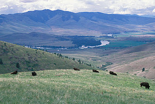
The Beaverhead–Deerlodge National Forest is the largest of the National Forests in Montana, United States. Covering 3.36 million acres (13,600 km2), the forest is broken into nine separate sections and stretches across eight counties in the southwestern area of the state. President Theodore Roosevelt named the two forests in 1908 and they were merged in 1996. Forest headquarters are located in Dillon, Montana. In Roosevelt's original legislation, the Deerlodge National Forest was called the Big Hole Forest Reserve. He created this reserve because the Anaconda Copper Mining Company, based in Butte, Montana, had begun to clearcut the upper Big Hole River watershed. The subsequent erosion, exacerbated by smoke pollution from the Anaconda smelter, was devastating the region. Ranchers and conservationists alike complained to Roosevelt, who made several trips to the area. (Munday 2001)

Karl or Philipp Carl Sprengel was a German botanist from Schillerslage.

Justus Liebig's Annalen der Chemie was one of the oldest and historically most important journals in the field of organic chemistry worldwide. It was established in 1832 and edited by Justus von Liebig with Friedrich Wöhler and others until Liebig's death in 1873. The journal was originally titled Annalen der Pharmacie; its name was changed to Justus Liebig's Annalen der Chemie in 1874. In its first decades of publishing, the journal was both a periodical containing news of the chemical and pharmaceutical fields and a publisher of primary research. During this time, it was noted to contain rebuttals and criticism of the works it published, inserted by Justus von Liebig during his tenure as an editor. After 1874, changes were made to editorial policies, and the journal published only completed research; later on, in the 20th century, its focus was narrowed to only print articles on organic chemistry, though it had always placed emphasis on the field. The journal was especially influential in the mid-19th century, but by the post-World War II period was considered "no longer as preeminent as it once was".

George F. Grant was an American angler, author and conservationist from Butte, Montana. He was active for many years on the Big Hole River.
The Little Belt Mountains are a section of the Rocky Mountains in the U.S. state of Montana. Situated mainly in the Lewis and Clark National Forest, the mountains are used for logging and recreation for the residents of Great Falls, Montana. Showdown is a ski area located within the mountains located off US Highway 89 which splits the mountains in half connecting White Sulphur Springs and Belt, MT. The highest point in the Little Belt Range is Big Baldy Mountain at 9,467 feet (2,886 m).

Little Butte Creek is a 17-mile-long (27 km) tributary of the Rogue River in the U.S. state of Oregon. Its drainage basin consists of approximately 354 square miles (917 km2) of Jackson County and another 19 square miles (49 km2) of Klamath County. Its two forks, the North Fork and the South Fork, both begin high in the Cascade Range near Mount McLoughlin and Brown Mountain. They both flow generally west until they meet near Lake Creek. The main stem continues west, flowing through the communities of Brownsboro, Eagle Point, and White City, before finally emptying into the Rogue River about 3 miles (5 km) southwest of Eagle Point.

Big Butte Creek is a 12-mile-long (19 km) tributary of the Rogue River in the U.S. state of Oregon. It drains approximately 245 square miles (635 km2) of Jackson County. Its two forks, the North Fork and the South Fork, both begin high in the Cascade Range near Mount McLoughlin. Flowing predominantly west, they meet near the city of Butte Falls. The main stem flows generally northwest until it empties into the Rogue Falls was incorporated in 1911, and remains the only incorporated town within the watershed's boundaries.
The Montana valley and foothill grasslands are an ecoregion of northwestern North America in the northern United States and southern Canada.
Lewis and Clark Pass is a mountain pass on the continental divide in Montana, United States, at an elevation of 6,424 feet (1,958 m) above sea level. The pass lies at the head of the drainages of the west-flowing Blackfoot River and the east-flowing Dearborn River, in the Helena National Forest in Lewis and Clark County. The Continental Divide Trail traverses north and south through the pass.

The Montana Arctic grayling is a North American freshwater fish in the salmon family Salmonidae. The Montana Arctic grayling, native to the upper Missouri River basin in Montana and Wyoming, is a disjunct population or subspecies of the more widespread Arctic grayling. It occurs in fluvial and adfluvial, lacustrine forms. The Montana grayling is a species of special concern in Montana and had candidate status for listing under the national Endangered Species Act. It underwent a comprehensive status review by the U.S. Fish and Wildlife Service, which in 2014 decided not to list it as threatened or endangered. Current surviving native populations in the Big Hole River and Red Rock River drainages represent approximately four percent of the subspecies' historical range.

Silver Bow Creek is a 26-mile-long (42 km) headwater stream of the Clark Fork (river) originating within the city limits of Butte, Montana, from the confluence of Little Basin and Blacktail Creeks. A former northern tributary, Yankee Doodle Creek, no longer flows directly into Silver Bow Creek as it is now captured by the Berkeley Pit. Silver Bow Creek flows northwest and north through a high mountain valley, passing east of Anaconda, Montana, where it becomes the Clark Fork at the confluence with Warm Springs Creek.
| International | |
|---|---|
| National | |