Related Research Articles

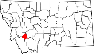
Silver Bow County is a county in the U.S. state Montana. As of the 2020 census, the population was 35,133. Its county seat is Butte. In 1977, the city and county governments consolidated to form the single entity of Butte-Silver Bow. Additionally, the town of Walkerville is a separate municipality from Butte and is within the county.

Walkerville is a town in Silver Bow County, Montana, United States, that is an enclave of the consolidated city-county of Butte. The population was 639 at the 2020 census. Walkerville is a suburb of Butte, and the only other incorporated community in the county, as well as the only part of the county that is not part of Butte.

The Berkeley Pit is a former open pit copper mine in the western United States, located in Butte, Montana. It is one mile (1.6 km) long by one-half mile (800 m) wide, with an approximate depth of 1,780 feet (540 m). It is filled to a depth of about 900 feet (270 m) with water that is heavily acidic, about the acidity of Coca-Cola, lemon juice, or gastric acid. As a result, the pit is laden with heavy metals and dangerous chemicals that leach from the rock, including copper, arsenic, cadmium, zinc, and sulfuric acid.
Venus Alley was a famous red-light district once located in Butte, Montana in the United States. It flourished from the late 19th century through the early 20th century and was one of the last openly tolerated urban prostitution districts in the American West, along with the one in Reno, Nevada. It was closed in the 1970s.
Silver Bow is a neighborhood in Butte, Montana, United States. It lies near the interchange of Interstate 15 and Interstate 90, near Rocker. It is the location of a major rail junction on the Burlington Northern Railroad. Silver Bow is at Exit 119 off I-15, near the Port of Montana. It is well known locally as the location of the Silver Bow Twin Drive-In.
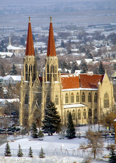
The Diocese of Helena is the Latin Church ecclesiastical territory or diocese of the Catholic Church in western Montana with its cathedral located in Helena. The diocese was created from the year-old Apostolic Vicariate of Montana on March 7, 1884, while Montana was still a territory. The Diocese of Helena is a suffragan diocese in ecclesiastical province of the Archdiocese of Portland in Oregon, a province that encompasses Oregon, Idaho, and Montana.
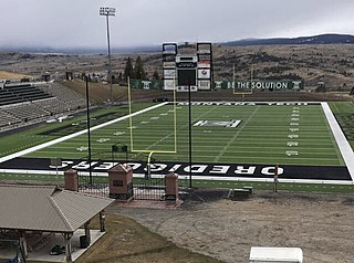
Alumni Coliseum, officially Bob Green Field at Alumni Coliseum, is a 2,000-seat college football stadium in the western United States, located on the campus of Montana Technological University in Butte, Montana. It is the home of the NAIA Montana Tech Orediggers.

The Granite Mountain/Speculator Mine disaster of June 8, 1917, occurred as a result of a fire in a copper mine, and was the most deadly event in underground hard rock mining in United States history. Most men died of suffocation underground as the fire consumed their oxygen; a total of 168 miners were killed. The Butte, Montana copper mines were at full wartime production to support the US in World War I. Miners had been seeking improved working conditions, as they were at high risk.

The Butte–Anaconda Historic District is a National Historic Landmark (NHL) that spans parts of Walkerville, Butte and Anaconda, Montana, United States. It has the most resources of any U.S. National Historic Landmark District.
Glen is an census-designated place in Beaverhead County, Montana, United States. Glen has a post office with a ZIP code of 59732. Glen lies on U.S. Route 91, south of Melrose and north of Dillon. The Big Hole River runs past the east side of the town.
Rocker is a suburb of Butte, Montana, United States, located at the coordinates of N 46° 0'11.74" W 112° 36'22.10". Rocker lies three miles west of Butte.

Melrose is a small community in Silver Bow County, Montana, United States. It is 34 miles (55 km) south of Butte and about 30 miles (48 km) north of Dillon. The zip code is 59743.
Divide is a rural community in Silver Bow County, Montana, United States. It is administered as part of Butte.
Square Butte is a name used for 11 buttes in Montana. Two of the most prominent buttes are located in a) Cascade County, Montana, about 22 miles (35 km) due west of Great Falls and in b) Chouteau County, Montana, about 50 miles (80 km) due east of Great Falls and about 15 miles (24 km) due east of the Highwood Mountains. Charles Marion Russell, the noted Montana western artist used both features as background in his paintings of Montana.
Fairmont Hot Springs Resort is a resort in Silver Bow County, Montana, United States.
References
- ↑ "Ramsay". Geographic Names Information System . United States Geological Survey, United States Department of the Interior . Retrieved November 18, 2016.
- ↑ "Ramsay ZIP Code". zipdatamaps.com. 2022. Retrieved November 11, 2022.
- ↑ "Ramsay". Montana Place Names Companion. Montana Historical Society. Retrieved 8 April 2021.
Municipalities and communities of Silver Bow County, Montana, United States | ||
|---|---|---|
| City |  | |
| Town | ||
| Unincorporated communities | ||
| Ghost town | ||
| Neighborhoods | ||
| Footnotes | ‡This populated place also has portions in an adjacent county or counties | |
Coordinates: 46°00′21″N112°41′10″W / 46.00583°N 112.68611°W
| | This Silver Bow County, Montana state location article is a stub. You can help Wikipedia by expanding it. |