U.S. Route 93 (US 93) is a major north–south United States highway in the western United States. The southern terminus is at US 60 in Wickenburg, Arizona. The northern terminus is at the Canada–US border north of Eureka in Lincoln County, Montana, where the roadway continues into Roosville, British Columbia, as Highway 93. Major cities that US 93 travels through include: Kingman, Arizona; Las Vegas, Nevada; Twin Falls, Idaho; and Missoula, Montana.
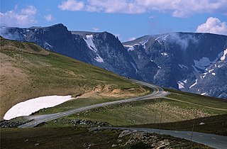
The Beartooth Highway is an All-American Road on a section of U.S. Route 212 in Montana and Wyoming between Red Lodge and the Northeast entrance of Yellowstone National Park, passing over the Beartooth Pass in Wyoming at 10,947 feet (3,337 m) above sea level. It has been called "the most beautiful drive in America," by late CBS correspondent Charles Kuralt. Because of heavy snowfall at the top, the pass is usually open each year only from mid May through mid October, weather conditions permitting.
U.S. Route 212 (US 212) is a spur of U.S. Route 12. It runs for 949 miles (1,527 km) from Minnesota Highway 62 at Edina, Minnesota to Yellowstone National Park. It does not intersect U.S. 12 now, but it once had an eastern terminus at U.S. 12 in St. Paul, Minnesota.
Montana Highway 2 (MT 2) is a 63.241-mile-long (101.777 km) state highway in the southern part of the U.S. state of Montana. It extends from Interstate 15 (I-15) and I-90 in Butte to I-90 in Three Forks. Previously, this roadway was a part of U.S. Route 10 (US 10).

The Montana Department of Transportation (MDT) is a governmental agency in the U.S. state of Montana, responsible for numerous programs related to the construction, maintenance, and monitoring of Montana's transportation infrastructure and operations. While most of MDT's programs relate to the state's highway network, Montana's railroads and airports are also under the agency's purview.
Highway 84 is a 28.904-mile-long (46.516 km) east–west state highway in the U.S. State of Montana. MT 84's western terminus is at U.S. Route 287 in the small community of Norris and the eastern terminus is at US 191 and MT 85 at Four Corners. The highway's eastern terminus, about 7 miles (11 km) west of Bozeman, is a location known locally as "Four Corners." From Four Corners, US 191 runs east to Bozeman, and south to West Yellowstone; Highway 84 travels west to Norris; and Montana Highway 85 runs north to Belgrade.
Montana Highway 78 in the U.S. state of Montana is a state highway running in a northerly direction from an intersection with U.S. Highway 212 (US 212) at the city of Red Lodge. It runs through Roscoe and Absarokee. The highway extends about 49 miles (79 km) to a northern terminus at Interstate 90 (I-90) in the town of Columbus.
Montana Highway 72 in the U.S. State of Montana is a route running northerly from the Wyoming state line to an intersection with U.S. Route 310 about one mile (1.6 km) south of the town of Bridger, a distance of approximately 21 miles (34 km). At the state line, the road becomes Wyoming Highway 120, which continues 38 miles (61 km) to the town of Cody.
Montana Highway 69 (MT 69) is a route running northerly from an intersection with MT 55 in the community of Whitehall. The highway extends approximately 38 miles (61 km) to an intersection with Interstate 15 (I-15) at the northern edge of the town of Boulder. Most of the route follows the Boulder River valley, a scenic and relatively unspoiled rural landscape.
Highway 59 (MT 59) is a 195.389-mile (314.448 km) state highway in Montana, United States, that connects Wyoming Highway 59 in Wyoming with Montana Highway 200 (MT 200) near the south end of the town of Jordan. WYO 59 continues south 57 miles (92 km) to the city of Gillette. The landscape traversed by MT 59 is mostly hilly and arid, largely used for open-range grazing; the only major commercial areas are the towns of Broadus and Miles City.

Highway 56 in the U.S. state of Montana is a route running in a northerly direction from an intersection with Montana Highway 200 between Noxon and Heron at an area locally known as "Bull River Junction", about 10 miles (16 km) east of the Idaho state line. The highway extends approximately 35 miles (56 km) to a northern terminus at an intersection with U.S. Route 2, about 3 miles (4.8 km) east of the town of Troy. The highway passes through a forested, mountainous landscape, and travels along the eastern shore of Bull Lake; the Cabinet Mountains are to the east. The entire route is within the boundary of the Kootenai National Forest. Highway 56 is known locally as the "Bull Lake Road" and "Bull River Highway".
Interstate 90 (I-90) is an east–west transcontinental Interstate highway across the northern United States, linking Seattle to Boston. The portion in the state of Montana is 554.10 miles (891.74 km) in length, passing through fourteen counties in central and southern Montana. Due to the large size of Montana, it is the longest segment of Interstate 90 within a single state.
Highway 55 in the U.S. State of Montana is a route running in a northerly direction from an intersection with MT 41 about 4 miles (6.4 km) north of the small town of Silver Star. The highway extends approximately 13 miles (21 km) to an interchange with Interstate 90 (I-90) at the north edge of the town of Whitehall. The route traverses largely agricultural land in the Jefferson River valley.
Montana Highway 40 is a 4.505-mile-long (7.250 km) state highway in Flathead County, Montana. It connects U.S. Route 93 south of Whitefish to US 2 west of Columbia Falls.

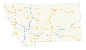
Transportation in Montana comprises many different forms of travel. Montana shares a long border with Canada, hence international crossings are prevalent in the northern section of the state; there are 13 road crossings and one rail crossing.
U.S. Highway 93 Alternate in the U.S. state of Montana is an alternate route of US 93 that bypasses the central business district of the city of Kalispell.
U.S. Highway 93 is a north–south United States Numbered Highway in the state of Montana.