Whitehall, Montana

Last updated

Whitehall, Montana
Whitehall Looking W.JPEG
Jefferson County Montana Incorporated and Unincorporated areas Whitehall Highlighted.svg
Location of Whitehall, Montana
Coordinates: 45°52′13″N112°5′54″W / 45.87028°N 112.09833°W / 45.87028; -112.09833
Country United States
State Montana
County Jefferson
Area
[1]
  Total0.70 sq mi (1.83 km2)
  Land0.70 sq mi (1.83 km2)
  Water0.00 sq mi (0.00 km2)
Elevation
[2]
4,360 ft (1,330 m)
Population
 (2020)
  Total1,006
  Density1,426.95/sq mi (550.94/km2)
Time zone UTC-7 (Mountain (MST))
  Summer (DST) UTC-6 (MDT)
ZIP code
59759
Area code 406
FIPS code 30-79900
GNIS feature ID0793224 [2]
Website townofwhitehall.org

Whitehall is a town in Jefferson County, Montana, United States. The population was 1,006 at the 2020 census. [3] It is part of the Helena Micropolitan Statistical Area.

Contents

Whitehall is within 60 miles of three major airports, four colleges and five ski resorts. There are numerous snowmobiling trails for winter riding and summer trail rides. The mountain ranges surrounding the valley, provide excellent opportunity for hunting big game. [4]

History

Whitehall began as a rail depot created by the Northern Pacific and Montana Railroad on September 25, 1889. The name for the depot came from E.G. Brooke, who was inspired by a similar town in which he stayed in Illinois while making his way westward. On September 3, 1890, the Jefferson County Commissioners accepted and filed the Townsite of Whitehall. [5]

Geography

Whitehall is in the Jefferson Valley, an area between the Tobacco Root and Highland Mountain ranges, and sits in the heart of the Deerlodge National Forest. The forest features pine and various species of fir, spruce and juniper. [6]

Waterbodies include seven nearby rivers and multiple mountain lakes. These waters contain several types of trout. [7] [8]

According to the United States Census Bureau, the town has a total area of 0.67 square miles (1.74 km2), all land. [9]

Whitehall3.JPG
Whitehall Montana looking SW.

Climate

According to the Köppen Climate Classification system, Whitehall has a semi-arid climate, abbreviated "BSk" on climate maps. [10]

Climate data for Whitehall, Montana
MonthJanFebMarAprMayJunJulAugSepOctNovDecYear
Mean daily maximum °F (°C)32.2
(0.1)
37.4
(3.0)
43.2
(6.2)
56.5
(13.6)
65.4
(18.6)
71.5
(21.9)
84.1
(28.9)
83.2
(28.4)
71.4
(21.9)
60.1
(15.6)
44.1
(6.7)
37.2
(2.9)
57.2
(14.0)
Daily mean °F (°C)20.9
(−6.2)
25.9
(−3.4)
31.3
(−0.4)
43
(6)
51.5
(10.8)
57.6
(14.2)
66.7
(19.3)
65.4
(18.6)
55.4
(13.0)
45.8
(7.7)
32.8
(0.4)
26.6
(−3.0)
43.6
(6.4)
Mean daily minimum °F (°C)9.6
(−12.4)
14.5
(−9.7)
19.4
(−7.0)
29.5
(−1.4)
37.7
(3.2)
43.8
(6.6)
49.3
(9.6)
47.5
(8.6)
39.5
(4.2)
31.4
(−0.3)
21.4
(−5.9)
16
(−9)
29.9
(−1.2)
Average precipitation inches (mm)0.3
(7.6)
0.2
(5.1)
0.5
(13)
0.8
(20)
1.8
(46)
2
(51)
0.9
(23)
0.8
(20)
1.1
(28)
0.5
(13)
0.2
(5.1)
0.3
(7.6)
9.5
(240)
Average snowfall inches (cm)4.5
(11)
4.2
(11)
5.4
(14)
2.8
(7.1)
0.7
(1.8)
0
(0)
0
(0)
0
(0)
0.7
(1.8)
1.5
(3.8)
2.3
(5.8)
4.5
(11)
26.6
(68)
Source: Weatherbase [11]

Demographics

Historical population
CensusPop.Note
1910 417
1920 62950.8%
1930 553−12.1%
1940 81847.9%
1950 92813.4%
1960 898−3.2%
1970 1,03515.3%
1980 1,030−0.5%
1990 1,0673.6%
2000 1,044−2.2%
2010 1,038−0.6%
2020 1,006−3.1%
U.S. Decennial Census [12] [3]

2010 census

As of the census [13] of 2010, there were 1,038 people, 473 households, and 283 families residing in the town. The population density was 1,549.3 inhabitants per square mile (598.2/km2). There were 538 housing units at an average density of 803.0 per square mile (310.0/km2). The racial makeup of the town was 94.0% White, 0.2% African American, 1.7% Native American, 0.5% Asian, 0.1% from other races, and 3.5% from two or more races. Hispanic or Latino of any race were 2.0% of the population.

There were 473 households, of which 26.8% had children under the age of 18 living with them, 44.4% were married couples living together, 9.7% had a female householder with no husband present, 5.7% had a male householder with no wife present, and 40.2% were non-families. 35.3% of all households were made up of individuals, and 15.9% had someone living alone who was 65 years of age or older. The average household size was 2.19 and the average family size was 2.84.

The median age in the town was 45.7 years. 23% of residents were under the age of 18; 7% were between the ages of 18 and 24; 19.6% were from 25 to 44; 33% were from 45 to 64; and 17.4% were 65 years of age or older. The gender makeup of the town was 51.9% male and 48.1% female.

2000 census

As of the census [14] of 2000, there were 1,044 people, 450 households, and 297 families residing in the town. The population density was 1,527.3 inhabitants per square mile (589.7/km2). There were 507 housing units at an average density of 741.7 per square mile (286.4/km2). The racial makeup of the town was 94.54% White, 2.49% Native American, 0.29% Asian, 0.10% Pacific Islander, 0.10% from other races, and 2.49% from two or more races. Hispanic or Latino of any race were 1.72% of the population.

There were 450 households, out of which 27.3% had children under the age of 18 living with them, 54.2% were married couples living together, 9.3% had a female householder with no husband present, and 34.0% were non-families. 29.8% of all households were made up of individuals, and 15.3% had someone living alone who was 65 years of age or older. The average household size was 2.32 and the average family size was 2.86.

In the town, the population was spread out, with 25.2% under the age of 18, 5.7% from 18 to 24, 25.3% from 25 to 44, 23.9% from 45 to 64, and 20.0% who were 65 years of age or older. The median age was 41 years. For every 100 females, there were 93.3 males. For every 100 females age 18 and over, there were 86.0 males.

The median income for a household in the town was $29,940, and the median income for a family was $38,833. Males had a median income of $30,682 versus $19,643 for females. The per capita income for the town was $15,527. About 8.8% of families and 12.0% of the population were below the poverty line, including 15.7% of those under age 18 and 7.6% of those age 65 or over.

Piedmont pond2.JPG
Tobacco Root Mountains from Piedmont Pond.

Arts and culture

Jefferson Valley Museum displays the history of the area, from the Native American tribes to the arrival of the railroads. [15] More than 10,000 artifacts are displayed in a restored dairy barn. [16]

The Lewis and Clark Caverns are limestone caves open for guided tours during the summer. There are trails for hiking or bicycling, camping, and plenty of wildlife watching. [17]

The Ringing Rocks area has unique rocks that resonate like a bell when struck. [18]

Whitehall Community Library is a public library which serves the town. [19]

Recreation

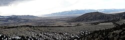
The multiple nearby rivers give great opportunity for fishing. There are four lakes within 60 miles which allow for boating. [4] The town is also near five ski resorts and three recreational hot springs. [4] Whitehall is between two mountain ranges. Both have hiking trails, backpacking, and camping opportunities. [20] [4]

Education

Public education in the town of Whitehall is provided by the Whitehall School District. [21] The district includes Whitehall Elementary School (grades K-6), Whitehall Middle School (grades 7-8), and Whitehall High School (grades 9-12). They are a Class B school [22] (108-306 students) which helps determine athletic competitions..

Whitehall's mascot is the Trojans, with school colors of purple and gold.

Media

The local newspaper is The Whitehall Ledger. [23] It is a weekly newspaper.

Two radio stations are licensed from Whitehall. KESW-LP is part of Jefferson County Radio, a network of stations owned by Jefferson County Disaster & Emergency Services. [24] KQLR is a K-Love station, owned by a non-profit Christian ministry. [25]

Infrastructure

Interstate 90 passes by the town with access via exit 249. The terminus of Montana Highway 55 is in Whitehall, while Montana Highway 69 begins. Montana Highway 2 travels through town from east to west.

The nearest airport is Bert Mooney Airport in Butte. [26]

Whitehall Medical Clinic provides local medical care. St. James Healthcare is the hospital in Butte. [27]

Notable people

Related Research Articles

<span class="mw-page-title-main">Silver Bow County, Montana</span> County in Montana, United States

Silver Bow County is a county in the U.S. state of Montana. As of the 2020 census, the population was 35,133. Its county seat is Butte. In 1977, the city and county governments consolidated to form the single entity of Butte-Silver Bow. Additionally, the town of Walkerville is a separate municipality from Butte and is within the county.

<span class="mw-page-title-main">Madison County, Montana</span> County in Montana, United States

Madison County is a county in the U.S. state of Montana. As of the 2020 census, the population was 8,623. Its county seat is Virginia City. The county was founded in 1865; at the time it was part of the Montana Territory.

<span class="mw-page-title-main">Lewis and Clark County, Montana</span> County in Montana, United States

Lewis and Clark County is a county located in the U.S. state of Montana. As of the 2020 census, the population was 70,973. Its county seat is Helena, the state capital. The numerical designation for Lewis and Clark County is 5. The county was established on June 2, 1865, as one of the nine original counties of the Territory of Montana named Edgerton County in honor of Sidney Edgerton, first Governor of the Territory of Montana, and was renamed Lewis and Clark County on March 1, 1868, in honor of explorers Meriwether Lewis and William Clark.

<span class="mw-page-title-main">Jefferson County, Montana</span> County in Montana, United States

Jefferson County is a county in Montana, United States. As of the 2020 census, the population was 12,085. Its county seat is Boulder. The county was created in 1865 and named for President Thomas Jefferson.

<span class="mw-page-title-main">Deer Lodge County, Montana</span> County in Montana, United States

Deer Lodge County is a county in the U.S. state of Montana. As of the 2020 census, the population was 9,421. It forms a consolidated city-county government with its county seat of Anaconda. The county was established in 1865.

<span class="mw-page-title-main">Lima, Montana</span> Town in Montana, United States

Lima is a town in Beaverhead County, Montana, United States. As of the 2020 census, the population was 212.

<span class="mw-page-title-main">Townsend, Montana</span> City in Montana, United States

Townsend is a city in and the county seat of Broadwater County, Montana, United States. The population was 1,787 at the 2020 census.

<span class="mw-page-title-main">Ekalaka, Montana</span> Town in Montana, United States

Ekalaka is a town in and the county seat of Carter County, Montana, United States. The population was 399 at the 2020 census.

<span class="mw-page-title-main">Cascade, Montana</span> Town in Cascade County, Montana, United States

Cascade is a town in Cascade County, Montana, United States. The population was 600 at the 2020 census. It is part of the Great Falls, Montana Metropolitan Statistical Area, which in 2020 had a population of 84,414. Cascade was incorporated in 1911.

<span class="mw-page-title-main">Glendive, Montana</span> City in Montana, United States

Glendive is a city in and the county seat of Dawson County, Montana, United States, and home to Dawson Community College. Glendive was established by the Northern Pacific Railway when they built the transcontinental railroad across the northern tier of the western United States from Minnesota to the Pacific Coast. The town was the headquarters for the Yellowstone Division that encompassed 875 route miles (1,408 km); 546 (879) in main line and 328 (528) in branches with the main routes from Mandan, North Dakota, to Billings, Montana, and from Billings to Livingston. The town of Glendive is an agricultural and ranching hub of eastern Montana sited between the Yellowstone River and the Badlands. Makoshika State Park is located just east of Glendive.

<span class="mw-page-title-main">West Yellowstone, Montana</span> Town in Montana, United States

West Yellowstone is a town in Gallatin County, Montana, United States, adjacent to Yellowstone National Park. The population was 1,272 at the 2020 census. West Yellowstone is served by Yellowstone Airport. It is part of the Bozeman, MT Micropolitan Statistical Area.

<span class="mw-page-title-main">Boulder, Montana</span> Town in Montana, United States

Boulder is a town in and the county seat of Jefferson County, Montana, United States. It is on the north bank of the Boulder River between Butte and Helena, slightly east of the Continental Divide, at the intersection of Interstate 15 and Montana Highway 69. The population was 1,201 at the 2020 census. It is part of the Helena Micropolitan Statistical Area, which includes all of Lewis and Clark and Jefferson counties; its population is 83,058 according to the 2020 Census.

<span class="mw-page-title-main">East Helena, Montana</span> City in Montana, United States

East Helena is a city in Lewis and Clark County, Montana, United States, approximately 5 miles (8 km) east of downtown Helena. The population was 1,944 at the 2020 census. It is part of the Helena Micropolitan Statistical Area, which includes all of Lewis and Clark and Jefferson counties; its population is 83,058 according to the 2020 Census.

<span class="mw-page-title-main">White Sulphur Springs, Montana</span> City in Montana, United States

White Sulphur Springs is a city in and the county seat of Meagher County, Montana, United States. The population was 955 at the 2020 census.

<span class="mw-page-title-main">Seeley Lake, Montana</span> CDP in Montana, United States

Seeley Lake is a census-designated place (CDP) in Missoula County, Montana, United States. It is part of the 'Missoula, Montana Metropolitan Statistical Area'. The town sits beside the 1,031.5 acres lake Seeley Lake. The population was 1,682 at the 2020 census.

<span class="mw-page-title-main">Hamilton, Montana</span> City in Montana, United States

Hamilton is a city that serves as the county seat of Ravalli County, Montana, United States. The population was 4,659 at the 2020 census.

<span class="mw-page-title-main">Brockton, Montana</span> Census-designated place in Montana, United States

Brockton is a census-designated place and former town in Roosevelt County, Montana, United States. The population was 358 at the 2020 census.

<span class="mw-page-title-main">Walkerville, Montana</span> Town in Montana, United States

Walkerville is a town in Silver Bow County, Montana, United States, that is an enclave of the consolidated city-county of Butte. The population was 639 at the 2020 census. Walkerville is a suburb of Butte, and the only other incorporated community in the county, as well as the only part of the county that is not part of Butte.

<span class="mw-page-title-main">Cardwell, Montana</span> Census-designated place in Montana, United States

Cardwell is a census-designated place (CDP) in Jefferson County, Montana, United States. The population was 62 at the 2020 census. It is part of the Helena Micropolitan Statistical Area.

<span class="mw-page-title-main">Clancy, Montana</span> Census-designated place in Montana, United States

Clancy is an unincorporated community and census-designated place (CDP) in Jefferson County, Montana, United States. The population was 1,661 at the 2010 census, up from 1,406 in 2000. It is part of the Helena Micropolitan Statistical Area.

References

  1. "ArcGIS REST Services Directory". United States Census Bureau. Retrieved September 5, 2022.
  2. 1 2 U.S. Geological Survey Geographic Names Information System: Whitehall, Montana
  3. 1 2 "U.S. Census website". United States Census Bureau . Retrieved November 2, 2021.
  4. 1 2 3 4 "Area Info". Whitehall Chamber of Commerce. Retrieved September 11, 2023.
  5. "Whitehall". Montana Place Names Companion. Montana Historical Society. Retrieved April 11, 2021.
  6. "Forest Resources of the Beaverhead-Deerlodge National Forest" (PDF). USDA Forest Service. August 2001. p. 5. Retrieved September 11, 2023.
  7. "Big Pipestone Creek". Montana Fish, Wildlife, and Parks. Retrieved September 11, 2023.
  8. "Jefferson River". Montana Fish, Wildlife, and Parks. Retrieved September 11, 2023.
  9. "US Gazetteer files 2010". United States Census Bureau . Retrieved December 18, 2012.
  10. Climate Summary for Whitehall, Montana
  11. "Whitehall Montana Historical Weather". Weatherbase . Retrieved April 15, 2015.
  12. "Census of Population and Housing". Census.gov. Retrieved June 4, 2015.
  13. "U.S. Census website". United States Census Bureau . Retrieved December 18, 2012.
  14. "U.S. Census website". United States Census Bureau . Retrieved January 31, 2008.
  15. "Jefferson Valley Museum". Montana Office of Tourism. Retrieved September 11, 2023.
  16. "Home page". Jefferson Valley Museum. Retrieved September 11, 2023.
  17. "Lewis & Clark Caverns State Park". Montana Fish, Wildlife, and Parks. Retrieved September 11, 2023.
  18. "Ringing Rocks". Bureau of Land Management. Retrieved September 11, 2023.
  19. "Whitehall Community Library". Whitehall Community Library. Retrieved April 13, 2021.
  20. "Tobacco Root Landscape" (PDF). US Forest Service. Retrieved September 11, 2023.
  21. "Home page". Whitehall School District. Retrieved September 11, 2023.
  22. "Member Schools". Montana High School Association. Retrieved April 19, 2021.
  23. "News". The Whitehall Ledger. Retrieved September 11, 2023.
  24. "KESW-LP". FCC. Retrieved September 11, 2023.
  25. "KQLR". FCC. Retrieved September 11, 2023.
  26. FAA Airport Form 5010 for BTM PDF . Federal Aviation Administration. Effective April 5, 2012.
  27. "Butte". Intermountain Health. Retrieved September 11, 2023.
  28. Rubin, Harriet (January 2009). "Becoming Sam Adams". Portland Monthly .
  29. Oyan, Katie (December 19, 1999). - "Chester R. 'Chet' Huntley". - Great Falls Tribune .
  30. Foley, Bill (April 17, 2009). "Life in the Big Leagues: Butte's Robbie Johnson living the dream". - The Montana Standard .
  31. Associated Press (October 20, 2002). - Entertainment: "Yeltsin visits Armenian brandy distillery". - c/o Amarillo Globe-News .