Vaughn, Montana

Last updated

Vaughn, Montana
CDP
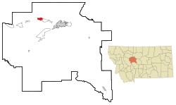
Cascade County Montana Incorporated and Unincorporated areas Vaughn Highlighted.svg
Location of Vaughn, Montana
Coordinates: 47°33′26″N111°33′5″W / 47.55722°N 111.55139°W / 47.55722; -111.55139
Country United States
State Montana
County Cascade
Area
[1]
  Total3.58 sq mi (9.26 km2)
  Land3.58 sq mi (9.26 km2)
  Water0.00 sq mi (0.00 km2)
Elevation
3,366 ft (1,026 m)
Population
 (2020)
  Total737
  Density206.15/sq mi (79.60/km2)
Time zone UTC-7 (Mountain (MST))
  Summer (DST) UTC-6 (MDT)
ZIP code
59487
Area code 406
FIPS code 30-76675
GNIS feature ID0778007

Vaughn is a census-designated place (CDP) in Cascade County, Montana, United States. The population was 737 at the 2020 census, compared to 658 at the 2010 census. [2] It is part of the Great Falls, Montana Metropolitan Statistical Area. It is named for Montana pioneer Robert Vaughn, whose homestead on the Vaughn Ranch encompassed part of the town.

Contents

History

While trying to make his fortune gold mining in Nelson Gulch near what is now Helena, Montana, Welsh American immigrant Robert Vaughn became convinced that Montana was excellent ranching and farming country. In the fall of 1869, he traveled into Chouteau County, Montana, which at the time covered nearly a sixth of the state. About 9 miles (14 km) upstream from where the Sun River joined the Missouri River, he decided to homestead. He returned to Helena and filed paperwork to claim the land, and learned he was the first individual to formally file for a homestead in Chouteau County. [3] [4] Although Vaughn started out farming, he quickly turned to ranching. He imported a large number of pure-bred cattle and horses, and his horses were some of the best in the state. [4]

Vaughn's young wife, Elizabeth, died of complications from childbirth on January 13, 1888. [5] Devastated by her death, Vaughn determined to sell his ranch and move into nearby Great Falls. Vaughn sold his ranch in 1890 to "Captain" Thomas Couch, a Cornish immigrant and expert miner who managed the Boston and Montana Consolidated Copper and Silver Mining Company in Great Falls. [4]

In 1890, the North Western Coal and Navigation Company constructed the Great Falls & Canada Railway, a narrow gauge railway (3-foot (0.91 m)) which ran from Sweet Grass, Montana (at the Canada–US border) to a terminus adjacent to the Robert Vaughn Ranch. [6] Designed to carry coal to Lethbridge, Alberta, the railroad was dubbed the "Turkey Trail". The railroad led to settlement around the terminus, and in 1910 Couch platted a town there. This town he named Vaughn, after Robert Vaughn. [7]

Geography

According to the United States Census Bureau, the CDP has a total area of 3.5 square miles (9.1 km2), all land.

The Sun River flows south of town.

Demographics

Historical population
CensusPop.Note
2020 737
U.S. Decennial Census [8]

As of the census [9] of 2000, there were 701 people, 264 households, and 195 families residing in the CDP. The population density was 198.4 inhabitants per square mile (76.6/km2). There were 287 housing units at an average density of 81.2 per square mile (31.4/km2). The racial makeup of the CDP was 92.72% White, 1.00% African American, 2.14% Native American, 0.71% Asian, 0.14% Pacific Islander, 0.14% from other races, and 3.14% from two or more races. Hispanic or Latino of any race were 1.43% of the population.

There were 264 households, out of which 40.9% had children under the age of 18 living with them, 57.6% were married couples living together, 11.0% had a female householder with no husband present, and 25.8% were non-families. 22.3% of all households were made up of individuals, and 7.2% had someone living alone who was 65 years of age or older. The average household size was 2.66 and the average family size was 3.11.

In the CDP, the population was spread out, with 32.0% under the age of 18, 5.4% from 18 to 24, 31.0% from 25 to 44, 22.8% from 45 to 64, and 8.8% who were 65 years of age or older. The median age was 33 years. For every 100 females, there were 113.1 males. For every 100 females age 18 and over, there were 104.7 males.

The median income for a household in the CDP was $31,250, and the median income for a family was $36,111. Males had a median income of $26,375 versus $18,984 for females. The per capita income for the CDP was $13,600. About 8.0% of families and 9.8% of the population were below the poverty line, including 8.7% of those under age 18 and 4.6% of those age 65 or over.

Media

The Fairfield Sun Times is the local newspaper. [10] The FM radio station KWGF is licensed there. [11]

Infrastructure

U.S. Route 89 cuts through town from east to west. It can be reached by exit 290 on Interstate 15.

Notable people

Related Research Articles

<span class="mw-page-title-main">Chouteau County, Montana</span> County in Montana, United States

Chouteau County is a county located in the North-Central region of the U.S. state of Montana. As of the 2020 census, the population was 5,895. Its county seat is Fort Benton. The county was established in 1865 as one of the original nine counties of Montana, and named in 1882 after Pierre Chouteau Jr., a fur trader who established a trading post that became Fort Benton, which was once an important port on the Missouri River.

<span class="mw-page-title-main">Cascade County, Montana</span> County in Montana, United States

Cascade County is a county located in the U.S. state of Montana. As of the 2020 census, the population was 84,414, making it the fifth-most populous county in Montana. Its county seat is Great Falls.

<span class="mw-page-title-main">Fort Shaw, Montana</span> CDP in Montana, United States

Fort Shaw is a census-designated place (CDP) in Cascade County, Montana, United States. The population was 280 at the 2010 census. Named for a former United States military outpost, it is part of the Great Falls, Montana Metropolitan Statistical Area.

<span class="mw-page-title-main">Simms, Montana</span> CDP in Montana, United States

Simms is a census-designated place (CDP) in Cascade County, Montana, United States. The population was 354 at the 2010 census. It is part of the Great Falls, Montana Metropolitan Statistical Area.

<span class="mw-page-title-main">Sun Prairie, Montana</span> CDP in Montana, United States

Sun Prairie is a census-designated place (CDP) in Cascade County, Montana, United States. The population was 1,630 at the 2010 census. It is part of the Great Falls Metropolitan Statistical Area and may have evolved as a remote suburb of Great Falls.

<span class="mw-page-title-main">Boneau, Montana</span> Census-designated place in Montana, United States

Boneau is a census-designated place (CDP) in Chouteau County, Montana, United States. The population was 380 at the 2010 census, up from 190 in 2000.

<span class="mw-page-title-main">Carter, Montana</span> Census-designated place in Montana, United States

Carter is a census-designated place (CDP) in Chouteau County, Montana, United States. The population was 58 at the 2010 census.

<span class="mw-page-title-main">Highwood, Montana</span> Census-designated place in Montana, United States

Highwood is an unincorporated community and census-designated place (CDP) in Chouteau County, Montana, United States. The population was 176 at the 2010 census.

<span class="mw-page-title-main">Loma, Montana</span> Census-designated place in Montana, United States

Loma is a census-designated place (CDP) in Chouteau County, Montana, United States. The population was 85 at the 2010 census.

<span class="mw-page-title-main">Bigfork, Montana</span> Unincorporated community in Montana, United States

Bigfork is a census-designated place (CDP) in Flathead County, Montana, United States. It is within Montana's Rocky Mountains. The population was 5,118 at the 2020 census, up from 4,270 in 2010.

<span class="mw-page-title-main">Hungry Horse, Montana</span> Unincorporated community in Montana, United States

Hungry Horse is an unincorporated community and census-designated place (CDP) in Flathead County, Montana, United States. The population was 828 at the 2020 census. The ZIP code for Hungry Horse is 59919.

<span class="mw-page-title-main">Sangrey, Montana</span> Census-designated place in Montana, United States

Sangrey is a census-designated place (CDP) in Hill County, Montana, United States. The population was 306 at the 2010 census, up from 263 in 2000.

<span class="mw-page-title-main">St. Pierre, Montana</span> Census-designated place in Montana, United States

St. Pierre is a census-designated place (CDP) in Hill County, Montana, United States, within the Rocky Boy Indian Reservation. The population of St. Pierre was 350 at the 2010 census, up from 289 in 2000.

<span class="mw-page-title-main">Montana City, Montana</span> Census-designated place in Montana, United States

Montana City is an unincorporated community and census-designated place (CDP) in Jefferson County, Montana, United States. The population was 2,715 at the 2010 census, up from 2,094 in 2000. It is part of the Helena Micropolitan Statistical Area.

<span class="mw-page-title-main">Augusta, Montana</span> Census-designated place in Montana, United States

Augusta is an unincorporated community and census-designated place (CDP) in Lewis and Clark County, Montana, United States. The population was 309 at the 2010 census and rose to 316 in the 2020 census. The most accepted version in the naming of this town is after Augusta Hogan, thought to be the first child born in this town, the daughter of J. D. Hogan, an early rancher.

<span class="mw-page-title-main">Alder, Montana</span> Census-designated place in Montana, United States

Alder is a census-designated place (CDP) in Madison County, Montana, United States. The population was 86 at the 2020 census. The community takes its name from Alder Creek, the site of the second major gold discovery in Montana.

<span class="mw-page-title-main">Antelope, Montana</span> CDP in Montana, United States

Antelope is a census-designated place (CDP) in Sheridan County, Montana, United States. The population was 51 at the 2010 census.

<span class="mw-page-title-main">Ballantine, Montana</span> CDP in Montana, United States

Ballantine is a census-designated place (CDP) in Yellowstone County, Montana, United States. It lies approximately nine miles (14 km) northeast of Billings on Interstate 94. The population was 346 at the 2000 census. Ballantine, along with the communities of Pompey's Pillar, Worden, and Huntley, is part of the Huntley Project, an irrigation district created by the United States Bureau of Reclamation. The majority of Ballantine's population lives on scattered farms and ranches surrounding the actual townsite.

<span class="mw-page-title-main">Parker School, Montana</span> Census-designated place in Montana, United States

Parker School is a census-designated place (CDP) in Hill and Chouteau counties in the U.S. state of Montana. The population was 340 at the 2010 census.

<span class="mw-page-title-main">Robert Vaughn (Montana rancher)</span>

Robert Vaughn was a Welsh immigrant to the United States and an important rancher, farmer, and businessman in the U.S. state of Montana before and after the early years of its statehood. He homesteaded the Vaughn ranch in the Sun River valley in Montana, building a sandstone mansion as his home there. The town of Vaughn, Montana, is named in his honor, and helped co-found the city of Great Falls, Montana. He built the Arvon Block, a hotel and stable in Great Falls, one of the city's earliest buildings; the ranch and the hotel are both listed on the National Register of Historic Places.

References

  1. "ArcGIS REST Services Directory". United States Census Bureau. Retrieved September 5, 2022.
  2. "Profile of General Population and Housing Characteristics: 2010 Demographic Profile Data (DP-1): Vaughn CDP, Montana". United States Census Bureau . Retrieved January 27, 2012.
  3. Vaughn, p. 64.
  4. 1 2 3 Walters, p. xii.
  5. Vaughn, p. 72-73.
  6. Poor, p. 242.
  7. Aarstad, et al., p. 278.
  8. "Census of Population and Housing". Census.gov. Retrieved June 4, 2016.
  9. "U.S. Census website". United States Census Bureau . Retrieved January 31, 2008.
  10. "Home page". Fairfield Sun Times. Retrieved November 24, 2023.
  11. "KWGF". FCC. Retrieved November 24, 2023.

Bibliography