Lake Great Falls

Last updated
Lake Great Falls
Map of Region of Great Falls, Montana (pg 88).jpg
Glacial Lake Great Falls.
USA Montana relief location map.jpg
Red pog.svg
Lake Great Falls
Location Cascade, Montana
Coordinates 47°30′14″N111°17′11″W / 47.503784°N 111.286353°W / 47.503784; -111.286353 Coordinates: 47°30′14″N111°17′11″W / 47.503784°N 111.286353°W / 47.503784; -111.286353 [1]
Lake type Glacial lake (former)
Primary inflows Laurentide Ice Sheet
Primary outflows Along the face of the Ice sheet.
Basin  countriesUnited States
Max. lengthabout 26 miles (42 km)
Max. widthabout 7.8 miles (12.6 km)
Surface area varied
Surface elevation3,500 m (11,500 ft)
References [2]

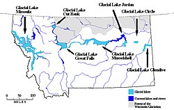
Lake Great Falls was a prehistoric proglacial lake which existed in what is now central Montana in the United States between 15,000 BCE and 11,000 BCE. [3] [4] [5] Centered on the modern city of Great Falls, Montana, Glacial Lake Great Falls extended as far north as Cut Bank, Montana, and as far south as Holter Lake. [6] At present-day Great Falls, the Glacial Lake Great Falls reached a depth of 600 feet (183 metres). [7]

Contents

Approximately 1.5 million years ago, the Missouri River, the Yellowstone River and Musselshell River all flowed northward into a terminal lake. [8] [9] During the last glacial period, the Laurentide and Cordilleran ice sheets pushed these lakes and rivers southward. [3] [8] Between 15,000 BCE and 11,000 BCE, the Laurentide Ice Sheet blocked the Missouri River and created Glacial Lake Great Falls. [3] [4] [5]

About 13,000 BCE, as the glacier retreated, Glacial Lake Great Falls emptied catastrophically in a glacial lake outburst flood. [5] The meltwater poured through the Highwood Mountains and eroded the hundred mile-long, 500-foot-deep (150 m) Shonkin Sag—one of the most famous prehistoric meltwater channels in the world. [10]

Map of Montana showing glacial lakes. Glacial lakes in Montana.jpg
Map of Montana showing glacial lakes.

Bibliography

See also

Related Research Articles

Great Falls, Montana City and county seat in Montana, United States

Great Falls is the third most populous city in the U.S. state of Montana and the county seat of Cascade County. The population was 60,442 according to the 2020 census. The city covers an area of 22.9 square miles (59 km2) and is the principal city of the Great Falls, Montana, Metropolitan Statistical Area, which encompasses all of Cascade County. The Great Falls MSA’s population stood at 84,414 in the 2020 census.

Lake Bonneville Former pluvial lake in western North America

Lake Bonneville was the largest Late Pleistocene paleolake in the Great Basin of western North America. The Western Interior Seaway preceded Lake Bonneville. Lake Bonneville was a pluvial lake that formed in response to an increase in precipitation and a decrease in evaporation as a result of cooler temperatures. Lake Bonneville covered much of what is now western Utah and at its highest level extended into present-day Idaho and Nevada. Many other hydrographically closed basins in the Great Basin contained expanded lakes during the Late Pleistocene, including Lake Lahontan in northwestern Nevada.

Wisconsin glaciation North American glacial ice sheet

The Wisconsin Glacial Episode, also called the Wisconsin glaciation, was the most recent glacial period of the North American ice sheet complex. This advance included the Cordilleran Ice Sheet, which nucleated in the northern North American Cordillera; the Innuitian ice sheet, which extended across the Canadian Arctic Archipelago; the Greenland ice sheet; and the massive Laurentide Ice Sheet, which covered the high latitudes of central and eastern North America. This advance was synchronous with global glaciation during the last glacial period, including the North American alpine glacier advance, known as the Pinedale glaciation. The Wisconsin glaciation extended from approximately 75,000 to 11,000 years ago, between the Sangamonian Stage and the current interglacial, the Holocene. The maximum ice extent occurred approximately 25,000–21,000 years ago during the last glacial maximum, also known as the Late Wisconsin in North America.

Proglacial lake Lake formed either by the damming action of a moraine during the retreat of a melting glacier, a glacial ice dam, or by meltwater trapped against an ice sheet

In geology, a proglacial lake is a lake formed either by the damming action of a moraine during the retreat of a melting glacier, a glacial ice dam, or by meltwater trapped against an ice sheet due to isostatic depression of the crust around the ice. At the end of the last ice age about 10,000 years ago, large proglacial lakes were a widespread feature in the northern hemisphere.

Laurentide Ice Sheet Continental glacier in North America during the last ice age

The Laurentide Ice Sheet was a massive sheet of ice that covered millions of square miles, including most of Canada and a large portion of the Northern United States, multiple times during the Quaternary glacial epochs, from 2.588 ± 0.005 million years ago to the present.

Interstate Park United States historic place

Interstate Park comprises two adjacent state parks on the Minnesota–Wisconsin border, both named Interstate State Park. They straddle the Dalles of the St. Croix River, a deep basalt gorge with glacial potholes and other rock formations. The Wisconsin park is 1,330 acres (538 ha) and the Minnesota park is 298 acres (121 ha). The towns of Taylors Falls, Minnesota and St. Croix Falls, Wisconsin are adjacent to the park. Interstate Park is within the Saint Croix National Scenic Riverway and the Ice Age National Scientific Reserve. The western terminus of the Ice Age National Scenic Trail is on the Wisconsin side. On the Minnesota side, two areas contain National Park Service rustic style buildings and structures that are listed on the National Register of Historic Places.

Great Falls (Missouri River) Series of waterfalls in Montana, United States

The Great Falls of the Missouri River are a series of waterfalls on the upper Missouri River in north-central Montana in the United States. From upstream to downstream, the five falls along a 10-mile (16 km) segment of the river are:

Glacial history of Minnesota

The glacial history of Minnesota is most defined since the onset of the last glacial period, which ended some 10,000 years ago. Within the last million years, most of the Midwestern United States and much of Canada were covered at one time or another with an ice sheet. This continental glacier had a profound effect on the surface features of the area over which it moved. Vast quantities of rock and soil were scraped from the glacial centers to its margins by slowly moving ice and redeposited as drift or till. Much of this drift was dumped into old preglacial river valleys, while some of it was heaped into belts of hills at the margin of the glacier. The chief result of glaciation has been the modification of the preglacial topography by the deposition of drift over the countryside. However, continental glaciers possess great power of erosion and may actually modify the preglacial land surface by scouring and abrading rather than by the deposition of the drift.

Glacial River Warren, also known as River Warren, was a prehistoric river that drained Lake Agassiz in central North America between about 13,500 and 10,650 BP calibrated years ago. A part of the uppermost portion of the former river channel was designated a National Natural Landmark in 1966.

Shonkin Sag

The Shonkin Sag is a prehistoric fluvioglacial landform located along the northern edge of the Highwood Mountains in the state of Montana in the United States. The Sag is a river channel formed by the Missouri River and glacial meltwater pouring from Glacial Lake Great Falls. It is one of the most famous prehistoric meltwater channels in the world.

Lake Albany

Glacial Lake Albany was a prehistoric North American proglacial lake that formed during the end of the Wisconsinan glaciation. It existed between 15,000 and 12,600 years ago and was created when meltwater from a retreating glacier, along with water from rivers such as the Iromohawk, became ice dammed in the Hudson Valley. Organic materials in Lake Albany deposits have been carbon dated to approximately 11,700 years ago. The lake spanned approximately 160 miles (260 km) from present-day Newburgh to Glens Falls.

Hill 57 is a sandstone-capped hill on the benchland northwest of Great Falls, Montana, United States. The origin of the name is in dispute, but probably derives from an advertisement for "Heinz 57" food products that was created on the hillside in the early 20th century. Hill 57 was home to a small and poverty-stricken community of Cree, Métis, and Ojibwe Native Americans from about the 1880s to the 1960s. Although much reduced in number, some of these landless Native Americans continue to reside on Hill 57. The extreme economic deprivation of Native Americans in the area led to the term "Hill 57" becoming a symbol and "a byword for urban Indian poverty". This community subsequently became the most widely cited example of "landless Indians" in Montana.

Lake Glendive

Glacial Lake Glendive was a glacial lake on the lower Yellowstone River. It formed in the valley of Yellowstone, during the late Pleistocene epoch south of the Keewatin Ice Sheet. As the ice sheet retreated northward, the lake drained into the modern Missouri River.

Lake Jordan (Montana)

Lake Jordan was a glacial lake formed during the late Pleistocene along the Jordan River. After the Laurentide Ice Sheet retreated, water melting off the glacier accumulated between the Rocky Mountains and the ice sheet. The lake drained along the front of the ice sheet, eastward towards the Yellowstone River and Glacial Lake Glendive.

Glacial Lake McKenzie

Before the Pleistocene Ice Age, circa two million years before present (YBP), the rivers in North, South Dakota and eastern Montana drained northeast into Canada and then into Hudson Bay. The Keewatin Lobe of the continental ice sheet, block the flow of water northward and impounded it along the ice front. Lakes formed, until the waters could find a new way to drain. Initially, the north flowing rivers followed the front of the glacier eastward and into a valley that passed between Garrison and Riverdale, to the Turtle Lake area, and on into Sheridan County. This is known as the preglacial McClean River. This valley became blocked by the glacier and the glacial lake identified as Lake McKenzie formed. Eventually, water level rose to crest the south ridge a point near Riverdale — at the site of the modern Garrison Dam and a diversion trench was cut. The modern Missouri River follows this pathway.

Lake Circle

Lake Circle was a glacial lake that formed during the late Pleistocene epoch along the Redwater River in eastern Montana. After the Laurentide Ice Sheet retreated, glacial ice melt accumulated in the basin surrounded by the ridges of the preglacial valley and the retreating glacier. Southwest of Nickwall are the remnants of a broad abandoned valley with long side slopes. The valley runs north from Redwater Creek to the Missouri River. The bottom is poorly drained and about 1 mile (1.6 km) in width. It lies 2,015 to 2,020 feet above the sea level and 40 to 50 feet above the Missouri River bottomland. The upland slopes are extensive, clear and flat. The valleys surrounding it are dissected with V-shaped coulees. The difference between the Redwater valley and those around it reflect stream erosion vs. lake sedimentation. The drift in the valleys, appears to be as left by the glacier in the previously created valleys. Using the dating of lake deposits near Great Falls, Montana, the Havre lobe of the Laurentide Ice Sheet dammed the ancestral Missouri River during the late Wisconsin Glacial Period.

Lake Musselshell

The basin that held Pleistocene Lake Musselshell is in the lower (north-flowing) reach of the river. It is underlain mostly by highly erodible Cretaceous Colorado shale, Montana group sandstone, siltstone and shale, and Hell Creek sandstone and shale. The bedrock is gently folded and affected by local faults and joints. There is a sequence of nine terraces and more than 100 glacial boulders. The terraces are older than the erratics as the erratics rest on the terraces.

Lake Cut Bank

Lake Cut Bank was a glacial lake formed during the late Pleistocene along the Missouri and Sun Rivers. After the Laurentide Ice Sheet retreated, water melting off the glacier accumulated between the Rocky Mountinas and the ice sheet. The lake drained along the front of the ice sheet, eastward towards the Judith River and the Missouri River.

Lake Chouteau

Lake Chouteau was a glacial lake formed during the late Pleistocene along the Teton River. After the Laurentide Ice Sheet retreated, water melting off the glacier accumulated between the Rocky Mountains and the ice sheet. The lake drained along the front of the ice sheet, eastward towards the Judith River and the Missouri River.

References

  1. dewiki
  2. Physiography and Glacial Geology of Eastern Montana and Adjacent Areas; William C. Alden; United States Government Printing Office: Washington, D.C.; 1932
  3. 1 2 3 Montagne J.L. "Quaternary System, Wisconsin Glaciation." Geologic Atlas of the Rocky Mountain Region. Denver: Rocky Mountain Association of Geologists, 1972.
  4. 1 2 Hill, Christopher L. and Valppu, Seppo H. "Geomorphic Relationships and Paleoenvironmental Context of Glaciers, Fluvial Deposits, and Glacial Lake Great Falls, Montana." Current Research in the Pleistocene. 14 (1997); Hill, Christopher L. "Pleistocene Lakes Along the Southwest Margin of the Laurentide Ice Sheet." Current Research in the Pleistocene. 17 (2000); Hill, Christopher L. and Feathers, James K. "Glacial Lake Great Falls and the Late-Wisconsin-Episode Laurentide Ice Margin." Current Research in the Pleistocene. 19 (2002); Reynolds, Mitchell W. and Brandt, Theodore R. Geologic Map of the Canyon Ferry Dam 30' x 60' Quadrangle, West-Central Montana: U.S. Geological Survey Scientific Investigations Map 2860, scale 1:100,000. Scientific Investigations Map 2860. Washington, D.C.: U.S. Geologic Survey, 2005.
  5. 1 2 3 Feathers, James K. and Hill, Christopher L. "Luminescence Dating of Glacial Lake Great Falls, Montana, U.S.A." Archived 2014-11-29 at the Wayback Machine XVI International Quaternary Association Congress. Stratigraphy and Geochronology Session. International Quaternary Association, Reno, 2003.
  6. Kidston, Martin J. "Prehistoric Find." Helena Independent Record. June 20, 2004.
  7. Alt, David and Hyndman, Donald W. Roadside Geology of Montana. Missoula, Mont.: Mountain Press Publishing, 1986. ISBN   0-87842-202-1; Stickney, Michael C. "Quaternary Geology and Faulting in the Helena Valley." In 1987 Guidebook for the Helena Area, West-Central Montana: Guidebook for the 12th Annual Field Conference. Richard B. Berg and Ray H. Breuninger, eds. Montana Bureau of Mines and Geology Special Publication 95. Helena, Mont.: Montana Bureau of Mines and Geology, 1987.
  8. 1 2 Clawson, Roger and Shandera, Katherine A. Billings: The City and the People. Helena, Mont.: Farcountry Press, 1998. ISBN   1-56037-037-8
  9. McRae, W.C. and Jewell, Judy. Moon Montana. 7th ed. Cambridge, Massachusetts: PublicAffairs, 2009. ISBN   1-59880-014-0
  10. Axline, Jon and Bradshaw, Glenda Clay. Montana's Historical Highway Markers. Rev. ed. Helena, Mont.: Montana Historical Society, 2008. ISBN   0-9759196-4-4; Bowman, Isaiah. "Forest Physiography: Physiography of the United States and Principles of Soils in Relation to Forestry." American Environmental Studies. Reprint ed. Charles Gregg, ed. New York: Arno Press, 1970. ISBN   0-405-02659-5