Lake Panamint

Last updated
Lake Panamint
Lake Gale
PanamintLake.JPG
Sometimes flooding causes part of the valley to re-form a lake
Relief map of California.png
Red pog.svg
Lake Panamint
Usa edcp relief location map.png
Red pog.svg
Lake Panamint
Coordinates 36°18′N117°18′W / 36.300°N 117.300°W / 36.300; -117.300 [1]
Primary inflows Owens River, local springs and drainages
Primary outflows Sometimes into Lake Manly

Lake Panamint (also known as Lake Gale [2] ) is a former lake that occupied Panamint Valley in California during the Pleistocene. It was formed mainly by water overflowing through the Owens River and which passed through Lake Searles into the Panamint Valley. At times, Lake Panamint itself overflowed into Death Valley and Lake Manly.

Contents

Geography and geomorphology

The lake developed within Panamint Valley, California. [3] This valley is a north–south trending depression that is bound between the Panamint Range in the northeast and the Argus Range-Slate Range in the west-southwest. The town of Ballarat lies in the valley, [4] and California State Route 190 crosses the former lake basin in its northern sector. [5] The existence of a lake in this valley was first postulated in 1914. [6]

Lake Panamint was about 97 kilometres (60 mi) long and 8.0–9.7 kilometres (5–6 mi) wide, making it a long and narrow lake. Both the main inlet and the potential outlet were located in a narrower southern part. [7] The total water volume was about 105 cubic kilometres (85,000,000 acre⋅ft). [8] The lake consisted of two basins that were sometimes separated by the Wildrose and Ash Hill Horsts: The northern Lake Hill basin close to Panamint Springs and Big Four Mine Road and the southern Ballarat basin [9] The total surface area of the lake was about 710 square kilometres (270 sq mi). [10]

A number of shorelines have been identified in the valley, indicating variable water levels. There are two principal shorelines at 580–610 metres (1,900–2,000 ft) and 341–385 metres (1,119–1,263 ft), the c.600 metres (2,000 ft) high shoreline is known as the Gale shoreline. There are a number of other shorelines [6] which span an elevation range of about 300 metres (980 ft). [11]

Geology

The Panamint Valley lies in the southern Basin and Range Province, which has been subject to extensive Quaternary tectonic activity characterized by crustal extension along normal faults as well as strike-slip fault activity. [12] Volcanic activity between 7.7 and 4 million years ago preceded the opening of the valley, leaving basalts stranded on either side. Subsequently, the Panamint Valley Fault Zone triggered subsidence of the valley floor and the separation of the formerly connected Darwin Plateau and Panamint Ranges. [13]

Little tectonic activity occurred while the valley was flooded [14] although lake sediments have been deformed by a 1.4–0.8 metres (4 ft 7 in – 2 ft 7 in) high fault scarp [4] and fault offsets are observed in many places of the Panamint Valley, [15] and while there is evidence for fault movement only a few hundred years ago, historical earthquake activity in the region is low. [13]

Tufa deposits have been found in the Panamint Valley, some of which form fringing reefs [16] and algal mounds. [17] Lake Panamint has left clay, [18] marl and silt deposits in Panamint Valley. [19] Cobble beaches developed at the Nadeau Road and Lower Water Canyon localities, [17] while wave-cut terraces were identified close to Ballarat [15] and Big Four Mine Road and delta deposits close to Panamint Springs. [20]

Hydrology

The deserts of the Southwestern United States were not always as dry as today. [21] During the ice ages, large lakes such as Lake Bonneville and Lake Lahontan developed in the Great Basin of the United States because of changes in the weather patterns of the region. In these times, the Laurentide Ice Sheet expanded and displaced the jet stream. [22]

Inflow

Map of the Owens River system California Pleistocene Lakes USGS.png
Map of the Owens River system

Lake Panamint was part of a chain of lakes that started with Owens Lake and continued through China Lake and Searles Lake into Lake Panamint. During wet periods, the upstream lakes would overflow and fill the downstream lakes until the latter overflowed as well into the next lake. [23] The source of this water was ultimately the Sierra Nevada and cations transported by this water have left their traces in the Panamint Valley. [24] Such overflow episodes occurred four times between 700,000 and 350,000 years ago and then again 150,000, 120,000, 24,000 and 10,000 years ago, [25] usually during periods where glaciers expanded on the Sierra Nevada; the last time where such water reached the Panamint Valley was 23,500 years before present. [21]

During oxygen isotope stage 4 Lake Panamint was filled by groundwater, [2] which comes in part from the Sierra Nevada [9] and in part from the Panamint Range. There are also some hot springs that show evidence of geothermal heating [6] and in general spring discharge sites close to faults are associated with peculiar coastal environments. [26] Desert drainages also added water to Lake Panamint, [7] some of these are still active today. [6]

Overflow

Lake Panamint itself overflowed at times into Death Valley and its lake Lake Manly [23] through Wingate Pass and Wingate Wash, forming a delta on the shorelines of Lake Manly where it entered the latter; [27] such overflow restricted the maximum height that water levels in Panamint Valley could reach to about 610 metres (2,000 ft) above sea level, [28] corresponding to a maximum depth of 285 metres (935 ft); [29] the high shorelines lie at the same elevation as the Wingate Pass sill. [15]

Overflow from Lake Panamint was a principal source of water for Lake Manly during the time the overflow was active. [30] When such overflow occurred is unclear [23] but apparently was restricted to oxygen isotope stage 6; during oxygen isotope stage 2 Lake Panamint was the terminal basin for the Owens River [2] and no overflow occurred after about 30,000 years before present. [31]

Biology

Charophytes and widgeonweeds grew in Lake Panamint. [2]

Freshwater snail [19] and other gastropod fossils have been found in lake deposits such as tufa; [16] genera found at Lake Panamint include Amnicola , Helisoma , Lymnaea , Valvata and Vorticifex . [32] Fecal pellets from brine shrimps have been found in lake deposits. [2]

Various fish such as suckers ( Catostomus ) and Western chubs ( Gila and Siphateles ) inhabited the lake when it was overflowing. Today they still occur in the Owens River system. [2] When Lake Panamint existed, California voles used the rivers reaching to and from the lake to propagate across the desert. [33]

Ostracods also lived in the lake waters, [2] including Candona , Cyprideis [32] and Limnocythere species. During shallow water periods, foraminifera also populated the lake, [2] and the presence of diatoms and other planktonic fossils was reported already in the 1950s. [6]

During the most recent highstand of Lake Panamint, humans occupied its shorelines and left stone tools. [19] Chipped-stone crescents, a common archeological artifact in California, have been found on the former shores of Lake Panamint [34] and geoglyphs have been observed in the northern sector of Lake Panamint. [5]

Lake history

Panamint Valley was flooded about five times over the last 100,000 years, [3] coinciding with glacial periods. [2] These lake stages have been assigned letter codes from oldest to youngest, "E", "F", "G", "H" and "I"; their chronology is often uncertain. [28] Lake stages at Lake Panamint coincided with the Tahoe and Tioga glacier advances in the Sierra Nevada. [35]

While the height of water levels during the Last Glacial Maximum was at first assumed to be about 383 metres (1,257 ft) above sea level, it was later found that Lake Panamint reached heights of 357–512 metres (1,171–1,680 ft). [36] It is possible however that around 22,600 ± 130 years ago Lake Panamint was split into a northern basin sourced from local drainages and a southern one receiving water from Lake Searles. By 15,050 ± 80 years ago Lake Panamint began to recede as overflow from Searles ceased. [16] By 14,925 radiocarbon years ago Lake Panamint was definitively receding. [37]

Presently, the Panamint Valley is considered to be part of physiographical region of the Sonoran Desert [3] and contains two playas, South Panamint Playa and North Panamint Playa. [38] Panamint Spring and Warm Sulphurs Spring are active in the northwestern and east-central sectors of the valley. [4]

Related Research Articles

<span class="mw-page-title-main">Geology of the Death Valley area</span> Geology of the area in California and Nevada

The exposed geology of the Death Valley area presents a diverse and complex set of at least 23 formations of sedimentary units, two major gaps in the geologic record called unconformities, and at least one distinct set of related formations geologists call a group. The oldest rocks in the area that now includes Death Valley National Park are extensively metamorphosed by intense heat and pressure and are at least 1700 million years old. These rocks were intruded by a mass of granite 1400 Ma and later uplifted and exposed to nearly 500 million years of erosion.

<span class="mw-page-title-main">Panamint Valley</span> Basin in the Mojave Desert, California

The Panamint Valley is a long basin located east of the Argus and Slate ranges, and west of the Panamint Range in the northeastern reach of the Mojave Desert, in eastern California, United States.

<span class="mw-page-title-main">Mono Basin</span>

The Mono Basin is an endorheic drainage basin located east of Yosemite National Park in California and Nevada. It is bordered to the west by the Sierra Nevada, to the east by the Cowtrack Mountains, to the north by the Bodie Hills, and to the south by the north ridge of the Long Valley Caldera.

Lake Mojave is an ancient former lake fed by the Mojave River that, through the Holocene, occupied the Silver Lake and Soda Lake basins in the Mojave Desert of San Bernardino County, California. Its outlet may have ultimately emptied into the Colorado River north of Blythe.

<span class="mw-page-title-main">Lake Manix</span> Lake in San Bernardino County, California

Lake Manix is a former lake fed by the Mojave River in the Mojave Desert. It lies within San Bernardino County, California. Located close to Barstow, this lake had the shape of a cloverleaf and covered four basins named Coyote, Cady/Manix, Troy and Afton. It covered a surface area of 236 square kilometres (91 sq mi) and reached an altitude of 543 metres (1,781 ft) at highstands, although poorly recognizable shorelines have been found at altitudes of 547–558 metres (1,795–1,831 ft). The lake was fed by increased runoff during the Pleistocene and overflowed into the Lake Mojave basin and from there to Lake Manly in Death Valley, or less likely into the Bristol Lake basin and from there to the Colorado River.

<span class="mw-page-title-main">Tuyajto Lake</span> Lake in Antofagasta Region, Chile

Tuyajto Lake is a salt lake located in the Antofagasta Region, northern Chile. Located at an elevation of about 4,010 metres (13,160 ft), its surface area presently fluctuates between 1.7–2.7 square kilometres (0.66–1.04 sq mi) but in the past it was considerably larger; this led to humans going to the lake and creating archeological sites there. Presently, the lake is groundwater-fed and has no surface outlet but water might seep out underground. It is part of the Los Flamencos Natural Reserve.

<span class="mw-page-title-main">Lake Corcoran</span> Lake in the state of California, United States

Lake Corcoran is an ancient lake that covered the Central Valley of California.

<span class="mw-page-title-main">Lake Cahuilla</span> Prehistoric lake in the Salton Sea basin of California

Lake Cahuilla was a prehistoric lake in California and northern Mexico. Located in the Coachella and Imperial valleys, it covered surface areas of 5,700 km2 (2,200 sq mi) to a height of 12 m (39 ft) above sea level during the Holocene. During earlier stages of the Pleistocene, the lake reached even higher elevations, up to 31–52 m (102–171 ft) above sea level. During the Holocene most of the water came from the Colorado River with little contribution from local runoff; in the Pleistocene local runoff was higher and it is possible that Lake Cahuilla was supported solely from local water sources during the Wisconsin glaciation. The lake overflowed close to Cerro Prieto into the Rio Hardy, eventually draining into the Gulf of California.
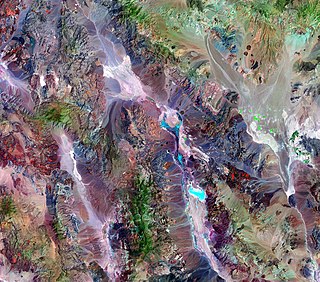
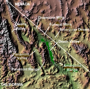
<span class="mw-page-title-main">Lake Manly</span> Lake in Death Valley, California, United States

Lake Manly was a pluvial lake in Death Valley, California, covering much of Death Valley with a surface area of 1,600 square kilometres (620 sq mi) during the so-called "Blackwelder stand". Water levels varied through its history, and the chronology is further complicated by active tectonic processes that have modified the elevations of the various shorelines of Lake Manly; during the Blackwelder stage they reached 47–90 metres (154–295 ft) above sea level. The lake received water mainly from the Amargosa River and at various points from the Mojave River and Owens River. The lake and its substantial catchment favoured the spread of a number of aquatic species, including some lizards, pupfish and springsnails. The lake probably supported a substantial ecosystem, and a number of diatoms developed there.

<span class="mw-page-title-main">Kelso Wash</span>

Kelso Wash is an ephemeral stream in San Bernardino County, California, United States, that drains into Soda Lake. The town of Kelso lies southeast of the wash.

<span class="mw-page-title-main">Lake Russell (prehistoric)</span> Former lake in California and Nevada, United States

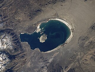
Lake Russell is a former lake stage of Mono Lake. It was named in honour of Israel Russell, but is also known as Lake Mono in contrast to the present-day lake. This lake was larger than present-day Mono Lake and occasionally overflowed first into the East Walker River and later into the Owens River. During its existence, glaciers from the Sierra Nevada reached to its shore.

Neopluvial is a term referring to a phase of wetter and colder climate that occurred during the late Holocene in the Western United States. During the Neopluvial, water levels in a number of now-dry lakes and closed lakes such as the Great Salt Lake rose and vegetation changed in response to increased precipitation. The event was not exactly synchronous everywhere, with neopluvial lake-level rises occurring between 6,000 and 2,000 years ago. It is correlative to the Neoglacial period.

<span class="mw-page-title-main">Lake Tecopa</span> Lake in California, USA

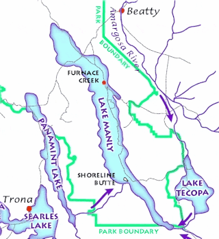
Lake Tecopa is a former lake in Inyo County, southern California. It developed during the Miocene and the Pleistocene within a tectonic basin close to the border with Nevada. Fed by the Amargosa River and some neighbouring washes, it eventually culminated to a surface area of 235 square kilometres (91 sq mi) around 186,000 years ago and left sediments. Afterwards, the Amargosa River cut a gorge out of the lake and into Death Valley with its Lake Manly, draining the lake. The present-day towns of Shoshone, California and Tecopa, California lie within the basin of the former lake.

<span class="mw-page-title-main">Big Pine volcanic field</span> Volcanic field in Inyo County, California

Big Pine volcanic field is a volcanic field in Inyo County, California. The volcanic field covers a surface area of 500 square kilometres (190 sq mi) within the Owens Valley east of the Sierra Nevada and consists of lava flows, one rhyolitic coulee and about 40 volcanic vents including cinder cones. Some vents are simple conical cinder cones while others are irregular scoria cones. Glaciers and former lakes have modified lava flows.

<span class="mw-page-title-main">Ubehebe Craters</span> Volcanic field in Death Valley of California

The Ubehebe Craters are a volcanic field in the northern Death Valley of California, consisting of 14–16 craters in a 3-square-kilometre (1.2 sq mi) area. The largest of the craters is the 800 metres (2,600 ft) wide and 235 metres (771 ft) deep Ubehebe Crater. Many of the craters, though, are partially buried and thus poorly recognizable. Other volcanic features there include a remnant of a scoria cone and a tuff cone.

<span class="mw-page-title-main">Salar de Punta Negra</span> Saltpan in Antofagasta Region, Chile

Salar de Punta Negra is a saltpan in the Antofagasta Region of Chile with a surface area of about 230 square kilometres (89 sq mi). It is surrounded by deposits left by dry valleys that descend the Western Cordillera. These dry valleys, from mountains such as the Llullaillaco volcano, carry water only occasionally. More permanent sources of water, in the form of springs, also exist at Salar de Punta Negra.

<span class="mw-page-title-main">Lake Modoc</span> Former lake in California and Oregon

Lake Modoc is a former lake in California and Oregon, in the location of present-day Upper Klamath Lake, Lower Klamath Lake and Tule Lake. It existed during the Pliocene and Pleistocene epochs, its formation probably influenced by volcanism and faulting. The bed of the former lake had plentiful resources for early humans, and today it is used for agriculture.

<span class="mw-page-title-main">Lake Alamosa</span> Former lake in Colorado, United States

Lake Alamosa is a former lake in Colorado. It existed from the Pliocene to the middle Pleistocene in the San Luis Valley, fed by glacial meltwater from surrounding mountain ranges. Water levels waxed and waned with the glacial stages until at highstand the lake reached an elevation of 2,335 meters (7,661 ft) and probably a surface of over 4,000 square kilometers (1,500 sq mi), but only sparse remains of the former waterbody are visible today. The existence of the lake was postulated in the early 19th century and eventually proven in the early 20th century.

<span class="mw-page-title-main">Lake Estancia</span> Prehistoric lake in New Mexico, United States

Lake Estancia was a lake formed in the Estancia Valley, central New Mexico, which left various coastal landforms in the valley. The lake was mostly fed by creek and groundwater from the Manzano Mountains, and fluctuated between freshwater stages and saltier stages. The lake had a diverse fauna, including cutthroat trout; they may have reached it during a possible past stage where it was overflowing.

<span class="mw-page-title-main">Lake San Agustín</span> Former lake in New Mexico, United States

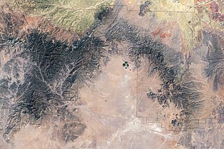
Lake San Agustín is a former lake in New Mexico, which developed as a pluvial lake in the Plains of San Agustín during Pleistocene glacial periods. During its highstands it covered an area of 1,200 square kilometres (460 sq mi) with a maximum depth of 70 metres (230 ft), and split into several separate lakes while drying out. The lake last appeared during the last glacial maximum (LGM) and dried out at the beginning of the Holocene, with the last remnant disappearing about 5,000 years ago.

References

  1. Petrie, G. M. (1984). "Consideration of future climatic changes in three geologic settings". International Nuclear Information System.
  2. 1 2 3 4 5 6 7 8 9 Jayko, A.S.; Forester, R.M.; Smith, G.R. (December 2014). "Siphateles (Gila) sp. and Catostomus sp. from the Pleistocene OIS-6 Lake Gale, Panamint Valley, Owens River system, California". AGU Fall Meeting Abstracts. 2014: 23C–1407. Bibcode:2014AGUFMPP23C1407J.
  3. 1 2 3 Post 1984, p. 147.
  4. 1 2 3 Zhang et al. 1990, p. 4859.
  5. 1 2 Davis, Emma Lou; Winslow, Sylvia (1965). "Giant Ground Figures of the Prehistoric Deserts". Proceedings of the American Philosophical Society. 109 (1): 8–21. JSTOR   985774.
  6. 1 2 3 4 5 Jayko et al. 2008, p. 154.
  7. 1 2 Phalen 1919, p. 174.
  8. Phalen 1919, p. 175.
  9. 1 2 Jayko et al. 2008, p. 153.
  10. Smith, George I. (2000). "AAPG Studies in Geology #46, Chapter 56: Late Pliocene and Pleistocene Searles Lake, California, U.S.A." : 591–595.{{cite journal}}: Cite journal requires |journal= (help)
  11. Jayko et al. 2008, p. 155.
  12. Zhang et al. 1990, p. 4857.
  13. 1 2 Zhang et al. 1990, p. 4858.
  14. Post 1984, p. 148.
  15. 1 2 3 Maxson, John H. (1950). "Physiographic Features of the Panamint Range, California". Geological Society of America Bulletin. 61 (2): 99–107. doi:10.1130/0016-7606(1950)61[99:PFOTPR]2.0.CO;2. ISSN   0016-7606.
  16. 1 2 3 Jayko, A.S.; Forester, R.M.; Sharpe, S.; Smith, G.I. (December 2001). "The last Pluvial Highstand (Late Wisconsin, Tioga Age) in Panamint Valley, Southeast California". AGU Fall Meeting Abstracts. 2001: 42B–0530. Bibcode:2001AGUFMPP42B0530J.
  17. 1 2 Jayko et al. 2008, p. 164.
  18. Molineux, Bliamptis & Neal 1971, p. 5.
  19. 1 2 3 Hubbs, Bien & Suess 1965, p. 93.
  20. Jayko et al. 2008, p. 171.
  21. 1 2 Conroy et al. 2016, p. 93.
  22. Hostetler, S W; Giorgi, F (February 1992). "Use of a regional atmospheric model to simulate lake-atmosphere feedbacks associated with Pleistocene Lakes Lahontan and Bonneville". Climate Dynamics. 7 (1): 39. Bibcode:1992ClDy....7...39H. doi:10.1007/bf00204820. ISSN   0930-7575. S2CID   140174207.
  23. 1 2 3 Lowenstein, Tim K.; Li, Jianren; Brown, Christopher; Roberts, Sheila M.; Ku, Teh-Lung; Luo, Shangde; Yang, Wenbo (1 January 1999). "200 k.y. paleoclimate record from Death Valley salt core". Geology. 27 (1): 3. doi:10.1130/0091-7613(1999)027<0003:KYPRFD>2.3.CO;2. ISSN   0091-7613.
  24. Stewart, B. W.; Roof, S.; Boulanger, J.R.; Lowenstein, T.K. (December 2001). "Connectivity of Owens River System Paleo-Lakes During Quaternary Glacial Periods: The Strontium Isotope Record". AGU Fall Meeting Abstracts. 2001: 22A–0493. Bibcode:2001AGUFMPP22A0493S.
  25. Reheis, Marith (20 January 2017). "Highest Pluvial-Lake Shorelines and Pleistocene Climate of the Western Great Basin" . Quaternary Research. 52 (2): 201. doi:10.1006/qres.1999.2064. ISSN   0033-5894. S2CID   128533773.
  26. Jayko et al. 2008, p. 173.
  27. Hooke, Roger LeB. (1972). "Geomorphic Evidence for Late-Wisconsin and Holocene Tectonic Deformation, Death Valley, California". Geological Society of America Bulletin. 83 (7): 2092. doi:10.1130/0016-7606(1972)83[2073:GEFLAH]2.0.CO;2. ISSN   0016-7606.
  28. 1 2 Zhang et al. 1990, p. 4864.
  29. Rosenthal et al. 2017, p. 114.
  30. Caskey, S.; Lackey, H.G.; Klinger, R.E.; Wan, E.; Sarna-Wojcicki, A. (December 2006). "Age and Elevations of High-Level OIS2 Pluvial Lake Manly Shorelines, Northern and Central Death Valley: Implications for Lacustrine Sequence Stratigraphy in Southern Death Valley and the OIS6 Pluvial Lake Level". AGU Fall Meeting Abstracts. 2006: 23B–1760. Bibcode:2006AGUFMPP23B1760C.
  31. Conroy et al. 2016, p. 95.
  32. 1 2 Jayko et al. 2008, p. 159.
  33. Conroy et al. 2016, p. 94.
  34. Moss, Madonna L.; Erlandson, Jon M. (September 2013). "Waterfowl and Lunate Crescents in Western North America: The Archaeology of the Pacific Flyway". Journal of World Prehistory. 26 (3): 176. doi:10.1007/s10963-013-9066-5. ISSN   0892-7537. S2CID   161949450.
  35. Hubbs, Bien & Suess 1965, p. 94.
  36. Jayko et al. 2008, p. 152.
  37. Rosenthal et al. 2017, p. 134.
  38. Molineux, Bliamptis & Neal 1971, p. 2.

Sources