
The Wisconsin Glacial Episode, also called the Wisconsin glaciation, was the most recent glacial period of the North American ice sheet complex. This advance included the Cordilleran Ice Sheet, which nucleated in the northern North American Cordillera; the Innuitian ice sheet, which extended across the Canadian Arctic Archipelago; the Greenland ice sheet; and the massive Laurentide Ice Sheet, which covered the high latitudes of central and eastern North America. This advance was synchronous with global glaciation during the last glacial period, including the North American alpine glacier advance, known as the Pinedale glaciation. The Wisconsin glaciation extended from approximately 75,000 to 11,000 years ago, between the Sangamonian Stage and the current interglacial, the Holocene. The maximum ice extent occurred approximately 25,000–21,000 years ago during the last glacial maximum, also known as the Late Wisconsin in North America.

The Laurentide Ice Sheet was a massive sheet of ice that covered millions of square kilometers, including most of Canada and a large portion of the Northern United States, multiple times during the Quaternary glacial epochs, from 2.588 ± 0.005 million years ago to the present.

The Dissected Till Plains are physiographic sections of the Central Lowlands province, which in turn is part of the Interior Plains physiographic division of the United States, located in southern and western Iowa, northeastern Kansas, the southwestern corner of Minnesota, northern Missouri, eastern Nebraska, and southeastern South Dakota.

The Great Falls of the Missouri River are a series of waterfalls on the upper Missouri River in north-central Montana in the United States. From upstream to downstream, the five falls along a 10-mile (16 km) segment of the river are:
Sims Corner Eskers and Kames National Natural Landmark of Douglas County, Washington and nearby McNeil Canyon Haystack Rocks and Boulder Park natural landmarks contain excellent examples of Pleistocene glacial landforms. Sims Corner Eskers and Kames National Natural Landmark includes classic examples of ice stagnation landforms such as glacial erratics, terminal moraines, eskers, and kames. It is located on the Waterville Plateau of the Columbia Plateau in north central Washington state in the United States.

The glacial history of Minnesota is most defined since the onset of the last glacial period, which ended some 10,000 years ago. Within the last million years, most of the Midwestern United States and much of Canada were covered at one time or another with an ice sheet. This continental glacier had a profound effect on the surface features of the area over which it moved. Vast quantities of rock and soil were scraped from the glacial centers to its margins by slowly moving ice and redeposited as drift or till. Much of this drift was dumped into old preglacial river valleys, while some of it was heaped into belts of hills at the margin of the glacier. The chief result of glaciation has been the modification of the preglacial topography by the deposition of drift over the countryside. However, continental glaciers possess great power of erosion and may actually modify the preglacial land surface by scouring and abrading rather than by the deposition of the drift.
Minneapolis is the largest city in the state of Minnesota in the United States, and the county seat of Hennepin County.
The River Warren Falls was a massive waterfall on the glacial River Warren initially located in present-day Saint Paul, Minnesota, United States. The waterfall was 2700 feet (823 m) across and 175 feet (53 m) high.

The Ice Age Floods National Geologic Trail or Ice Age Floods Trail is designated as the first National Geologic Trail in the United States. It will consist of a network of routes connecting facilities that will provide interpretation of the geological consequences of the Glacial Lake Missoula floods of the last glacial period that began about 110,000 years ago.
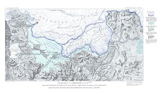
Lake Great Falls was a prehistoric proglacial lake which existed in what is now central Montana in the United States between 15,000 BCE and 11,000 BCE. Centered on the modern city of Great Falls, Montana, Glacial Lake Great Falls extended as far north as Cut Bank, Montana, and as far south as Holter Lake. At present-day Great Falls, the Glacial Lake Great Falls reached a depth of 600 feet.

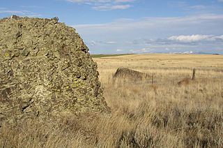
The Shonkin Sag is a prehistoric fluvioglacial landform located along the northern edge of the Highwood Mountains in the state of Montana in the United States. The Sag is a river channel formed by the Missouri River and glacial meltwater pouring from Glacial Lake Great Falls. It is one of the most famous prehistoric meltwater channels in the world.
Hill 57 is a sandstone-capped hill on the benchland northwest of Great Falls, Montana, United States. The origin of the name is in dispute, but probably derives from an advertisement for "Heinz 57" food products that was created on the hillside in the early 20th century. Hill 57 was home to a small and poverty-stricken community of Cree, Métis, and Ojibwe Native Americans from about the 1880s to the 1960s. Although much reduced in number, some of these landless Native Americans continue to reside on Hill 57. The extreme economic deprivation of Native Americans in the area led to the term "Hill 57" becoming a symbol and "a byword for urban Indian poverty". This community subsequently became the most widely cited example of "landless Indians" in Montana.
The Purcell Trench, also known as the Kootenay River Valley is a large valley on the western side of the northern part of North America's Rocky Mountains. The trench extends approximately 179 miles (288 km) from Lake Pend Oreille, Idaho, down the Kootenay River (north) to Kootenay Lake, up the north arm to Duncan Lake. It joins the Rocky Mountain Trench another 50 miles (80 km) northward at the south tip of Kinbasket Lake, in British Columbia. The trench bottom is 1 to 7 miles wide and is 1,750 to 2,100 feet above sea level. The trench is nearly a straight north or south line. Some of its topography has been carved into U-shaped glacial valleys, it is primarily a product of geologic faulting. The trench splits the Columbia Mountains between the Purcell Mountains on the east and the Selkirk Mountains on the west.

Glacial Lake Glendive was a glacial lake on the lower Yellowstone River. It formed in the valley of Yellowstone, during the late Pleistocene epoch south of the Keewatin Ice Sheet. As the ice sheet retreated northward, the lake drained into the modern Missouri River.

Lake Jordan was a glacial lake formed during the late Pleistocene along the Jordan River. After the Laurentide Ice Sheet retreated, water melting off the glacier accumulated between the Rocky Mountains and the ice sheet. The lake drained along the front of the ice sheet, eastward towards the Yellowstone River and Glacial Lake Glendive.

Before the Pleistocene Ice Age, circa two million years before present (YBP), the rivers in North, South Dakota and eastern Montana drained northeast into Canada and then into Hudson Bay. The Keewatin Lobe of the continental ice sheet, block the flow of water northward and impounded it along the ice front. Lakes formed, until the waters could find a new way to drain. Initially, the north flowing rivers followed the front of the glacier eastward and into a valley that passed between Garrison and Riverdale, to the Turtle Lake area, and on into Sheridan County. This is known as the preglacial McClean River. This valley became blocked by the glacier and the glacial lake identified as Lake McKenzie formed. Eventually, water level rose to crest the south ridge a point near Riverdale — at the site of the modern Garrison Dam and a diversion trench was cut. The modern Missouri River follows this pathway.
Lake Circle was a glacial lake that formed during the late Pleistocene epoch along the Redwater River in eastern Montana. After the Laurentide Ice Sheet retreated, glacial ice melt accumulated in the basin surrounded by the ridges of the preglacial valley and the retreating glacier. Southwest of Nickwall are the remnants of a broad abandoned valley with long side slopes. The valley runs north from Redwater Creek to the Missouri River. The bottom is poorly drained and about 1 mile (1.6 km) in width. It lies 2,015 to 2,020 feet above the sea level and 40 to 50 feet above the Missouri River bottomland. The upland slopes are extensive, clear and flat. The valleys surrounding it are dissected with V-shaped coulees. The difference between the Redwater valley and those around it reflect stream erosion vs. lake sedimentation. The drift in the valleys, appears to be as left by the glacier in the previously created valleys. Using the dating of lake deposits near Great Falls, Montana, the Havre lobe of the Laurentide Ice Sheet dammed the ancestral Missouri River during the late Wisconsin Glacial Period.

Lake Cut Bank was a glacial lake formed during the late Pleistocene along the Missouri and Sun Rivers. After the Laurentide Ice Sheet retreated, water melting off the glacier accumulated between the Rocky Mountinas and the ice sheet. The lake drained along the front of the ice sheet, eastward towards the Judith River and the Missouri River.
Lake Chouteau was a glacial lake formed during the late Pleistocene along the Teton River. After the Laurentide Ice Sheet retreated, water melting off the glacier accumulated between the Rocky Mountains and the ice sheet. The lake drained along the front of the ice sheet, eastward towards the Judith River and the Missouri River.

