
The Wisconsin Glacial Episode, also called the Wisconsin glaciation, was the most recent glacial period of the North American ice sheet complex. This advance included the Cordilleran Ice Sheet, which nucleated in the northern North American Cordillera; the Innuitian ice sheet, which extended across the Canadian Arctic Archipelago; the Greenland ice sheet; and the massive Laurentide Ice Sheet, which covered the high latitudes of central and eastern North America. This advance was synchronous with global glaciation during the last glacial period, including the North American alpine glacier advance, known as the Pinedale glaciation. The Wisconsin glaciation extended from approximately 75,000 to 11,000 years ago, between the Sangamonian Stage and the current interglacial, the Holocene. The maximum ice extent occurred approximately 25,000–21,000 years ago during the last glacial maximum, also known as the Late Wisconsin in North America.

The Laurentide Ice Sheet was a massive sheet of ice that covered millions of square kilometers, including most of Canada and a large portion of the Northern United States, multiple times during the Quaternary glacial epochs, from 2.588 ± 0.005 million years ago to the present.

Glacial landforms are landforms created by the action of glaciers. Most of today's glacial landforms were created by the movement of large ice sheets during the Quaternary glaciations. Some areas, like Fennoscandia and the southern Andes, have extensive occurrences of glacial landforms; other areas, such as the Sahara, display rare and very old fossil glacial landforms.

A tunnel valley is a U-shaped valley originally cut under the glacial ice near the margin of continental ice sheets such as that now covering Antarctica and formerly covering portions of all continents during past glacial ages. They can be as long as 100 km (62 mi), 4 km (2.5 mi) wide, and 400 m (1,300 ft) deep.

Lake Maumee was a proglacial lake and an ancestor of present-day Lake Erie. It formed about 14,000 Years Before Present (YBP) as the Huron-Erie Lobe of the Laurentide Ice Sheet retreated at the end of the Wisconsin glaciation. As water levels continued to rise the lake evolved into Lake Arkona and then Lake Whittlesey.

The glacial history of Minnesota is most defined since the onset of the last glacial period, which ended some 10,000 years ago. Within the last million years, most of the Midwestern United States and much of Canada were covered at one time or another with an ice sheet. This continental glacier had a profound effect on the surface features of the area over which it moved. Vast quantities of rock and soil were scraped from the glacial centers to its margins by slowly moving ice and redeposited as drift or till. Much of this drift was dumped into old preglacial river valleys, while some of it was heaped into belts of hills at the margin of the glacier. The chief result of glaciation has been the modification of the preglacial topography by the deposition of drift over the countryside. However, continental glaciers possess great power of erosion and may actually modify the preglacial land surface by scouring and abrading rather than by the deposition of the drift.

The proglacial lakes of Minnesota were lakes created in what is now the U.S. state of Minnesota in central North America in the waning years of the last glacial period. As the Laurentide Ice Sheet decayed at the end of the Wisconsin glaciation, lakes were created in depressions or behind moraines left by the glaciers. Evidence for these lakes is provided by low relief topography and glaciolacustrine sedimentary deposits. Not all contemporaneous, these glacial lakes drained after the retreat of the lobes of the ice sheets that blocked their outlets, or whose meltwaters fed them. There were a number of large lakes, one of which, Glacial Lake Agassiz, was the largest body of freshwater known to have existed on the North American continent; there were also dozens of smaller and more transitory lakes filled from glacial meltwater, which shrank or dried as the ice sheet retreated north.

Boulder Park National Natural Landmark, of Douglas County, Washington, along with the nearby McNeil Canyon Haystack Rocks and Sims Corner Eskers and Kames natural landmarks, illustrate well-preserved examples of classic Pleistocene ice stagnation landforms that are found in Washington. These landforms include numerous glacial erratics and haystack rocks that occur near and on the Withrow Moraine, which is the terminal moraine of the Okanogan ice lobe.
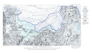
Lake Great Falls was a prehistoric proglacial lake which existed in what is now central Montana in the United States between 15,000 BCE and 11,000 BCE. Centered on the modern city of Great Falls, Montana, Glacial Lake Great Falls extended as far north as Cut Bank, Montana, and as far south as Holter Lake. At present-day Great Falls, the Glacial Lake Great Falls reached a depth of 600 feet.

The Shonkin Sag is a prehistoric fluvioglacial landform located along the northern edge of the Highwood Mountains in the state of Montana in the United States. The Sag is a river channel formed by the Missouri River and glacial meltwater pouring from Glacial Lake Great Falls. It is one of the most famous prehistoric meltwater channels in the world.

New England is a region in the North Eastern United States consisting of the states Rhode Island, Connecticut, Massachusetts, New Hampshire, Vermont, and Maine. Most of New England consists geologically of volcanic island arcs that accreted onto the eastern edge of the Laurentian Craton in prehistoric times. Much of the bedrock found in New England is heavily metamorphosed due to the numerous mountain building events that occurred in the region. These events culminated in the formation of Pangaea; the coastline as it exists today was created by rifting during the Jurassic and Cretaceous periods. The most recent rock layers are glacial conglomerates.

The Kankakee Torrent was a catastrophic flood that occurred about 19,000 BP calibrated years ago in the Midwestern United States. It resulted from a breach of moraines forming a large glacial lake fed by the melting of the Late Wisconsin Laurentide Ice Sheet. The point of origin of the flood was Lake Chicago. The landscape south of Chicago still shows the effects of the torrent, particularly at Kankakee River State Park and on the Illinois River at Starved Rock State Park.

Lake Kankakee formed 14,000 years before present (YBP) in the valley of the Kankakee River. It developed from the outwash of the Michigan Lobe, Saginaw Lobe, and the Huron-Erie Lobe of the Wisconsin glaciation. These three ice sheets formed a basin across Northwestern Indiana. It was a time when the glaciers were receding, but had stopped for a thousand years in these locations. The lake drained about 13,000 YBP, until reaching the level of the Momence Ledge. The outcropping of limestone created an artificial base level, holding water throughout the upper basin, creating the Grand Kankakee Marsh.

Glacial Lake Glendive was a glacial lake on the lower Yellowstone River. It formed in the valley of Yellowstone, during the late Pleistocene epoch south of the Keewatin Ice Sheet. As the ice sheet retreated northward, the lake drained into the modern Missouri River.

Lake Jordan was a glacial lake formed during the late Pleistocene along the Jordan River. After the Laurentide Ice Sheet retreated, water melting off the glacier accumulated between the Rocky Mountains and the ice sheet. The lake drained along the front of the ice sheet, eastward towards the Yellowstone River and Glacial Lake Glendive.

Before the Pleistocene Ice Age, circa two million years before present (YBP), the rivers in North, South Dakota and eastern Montana drained northeast into Canada and then into Hudson Bay. The Keewatin Lobe of the continental ice sheet, block the flow of water northward and impounded it along the ice front. Lakes formed, until the waters could find a new way to drain. Initially, the north flowing rivers followed the front of the glacier eastward and into a valley that passed between Garrison and Riverdale, to the Turtle Lake area, and on into Sheridan County. This is known as the preglacial McClean River. This valley became blocked by the glacier and the glacial lake identified as Lake McKenzie formed. Eventually, water level rose to crest the south ridge a point near Riverdale — at the site of the modern Garrison Dam and a diversion trench was cut. The modern Missouri River follows this pathway.
Lake Circle was a glacial lake that formed during the late Pleistocene epoch along the Redwater River in eastern Montana. After the Laurentide Ice Sheet retreated, glacial ice melt accumulated in the basin surrounded by the ridges of the preglacial valley and the retreating glacier. Southwest of Nickwall are the remnants of a broad abandoned valley with long side slopes. The valley runs north from Redwater Creek to the Missouri River. The bottom is poorly drained and about 1 mile (1.6 km) in width. It lies 2,015 to 2,020 feet above the sea level and 40 to 50 feet above the Missouri River bottomland. The upland slopes are extensive, clear and flat. The valleys surrounding it are dissected with V-shaped coulees. The difference between the Redwater valley and those around it reflect stream erosion vs. lake sedimentation. The drift in the valleys, appears to be as left by the glacier in the previously created valleys. Using the dating of lake deposits near Great Falls, Montana, the Havre lobe of the Laurentide Ice Sheet dammed the ancestral Missouri River during the late Wisconsin Glacial Period.
The basin that held Pleistocene Lake Musselshell is in the lower (north-flowing) reach of the river. It is underlain mostly by highly erodible Cretaceous Colorado shale, Montana group sandstone, siltstone and shale, and Hell Creek sandstone and shale. The bedrock is gently folded and affected by local faults and joints. There is a sequence of nine terraces and more than 100 glacial boulders. The terraces are older than the erratics as the erratics rest on the terraces.

Lake Cut Bank was a glacial lake formed during the late Pleistocene along the Missouri and Sun Rivers. After the Laurentide Ice Sheet retreated, water melting off the glacier accumulated between the Rocky Mountinas and the ice sheet. The lake drained along the front of the ice sheet, eastward towards the Judith River and the Missouri River.

