
Cape Cod is a peninsula extending into the Atlantic Ocean from the southeastern corner of Massachusetts, in the northeastern United States. Its historic, maritime character and ample beaches attract heavy tourism during the summer months. The name Cape Cod, coined in 1602 by Bartholomew Gosnold, is the ninth oldest English place-name in the U.S.

Woods Hole is a census-designated place in the town of Falmouth in Barnstable County, Massachusetts, United States. It lies at the extreme southwestern corner of Cape Cod, near Martha's Vineyard and the Elizabeth Islands. The population was 781 at the 2010 census.

The Last Glacial Period (LGP), also known colloquially as the Last Ice Age or simply the Ice Age, occurred from the end of the Last Interglacial to the end of the Younger Dryas, encompassing the period c. 115,000 – c. 11,700 years ago.
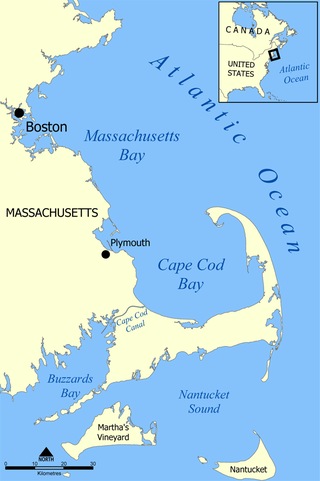
Cape Cod Bay is a large bay of the Atlantic Ocean adjacent to the U.S. state of Massachusetts. Measuring 604 square miles (1,560 km2) below a line drawn from Brant Rock in Marshfield to Race Point in Provincetown, Massachusetts, it is enclosed by Cape Cod to the south and east, and Plymouth County, Massachusetts, to the west. To the north of Cape Cod Bay lie Massachusetts Bay and the Atlantic Ocean. Cape Cod Bay is the southernmost extremity of the Gulf of Maine. Cape Cod Bay is one of the bays adjacent to Massachusetts that give it the name Bay State. The others are Narragansett Bay, Buzzards Bay, and Massachusetts Bay.
Nantucket Sound is a roughly triangular area of the Atlantic Ocean offshore from the U.S. state of Massachusetts. It is 30 miles (48 km) long and 25 miles (40 km) wide, and is enclosed by Cape Cod on the north, Nantucket on the south, and Martha's Vineyard on the west. Between Cape Cod and Martha's Vineyard it is connected to the Vineyard Sound. Ports on Nantucket Sound include Nantucket and Hyannis, Massachusetts.

Lake Hitchcock was a glacial lake that formed approximately 15,000 years ago in the late Pleistocene epoch. After the Laurentide Ice Sheet retreated, glacial ice melt accumulated at the terminal moraine and blocked up the Connecticut River, creating the long, narrow lake. The lake existed for approximately 3,000 years, after which a combination of erosion and continuing geological changes likely caused it to drain. At its longest, Lake Hitchcock stretched from the moraine dam at present-day Rocky Hill, Connecticut, to St. Johnsbury, Vermont. Although the rift valley through which the river flows above Rocky Hill actually continues south to New Haven, on Long Island Sound, the obstructing moraine at Rocky Hill diverted the river southeast to its present mouth at Old Saybrook.

A terminal moraine, also called an end moraine, is a type of moraine that forms at the terminal (edge) of a glacier, marking its maximum advance. At this point, debris that has accumulated by plucking and abrasion, has been pushed by the front edge of the ice, is driven no further and instead is deposited in an unsorted pile of sediment. Because the glacier acts very much like a conveyor belt, the longer it stays in one place, the greater the amount of material that will be deposited. The moraine is left as the marking point of the terminal extent of the ice.
Glacial Lake Connecticut formed over what is now Long Island Sound and coastal Connecticut at the fore edge of the ice sheet of the Wisconsin glaciation, as the lobe of the Laurentide Ice Sheet began to retreat, some 18 to 20,000 years before present. It was dammed by the terminal moraine that now forms the spine of Long Island and Fishers Island. About 15,000 BP, the moraine dam that impounded Lake Connecticut failed; the outlet, known as The Race for its tidal rip currents, lies between the North Fork of Long Island and Fishers Island. For a time, much of the lake bed was exposed to wind-driven erosion: the cue is found in soundings that reveal regional unconformities in the sediment bed of Long Island Sound.

Tuckernuck is an island in the town and former whaling port of Nantucket, Massachusetts, west of Nantucket Island and east of Muskeget Island. Its name allegedly means "a loaf of bread". The island has an area of about 900 acres. The highest point is about 50 feet (15 m).
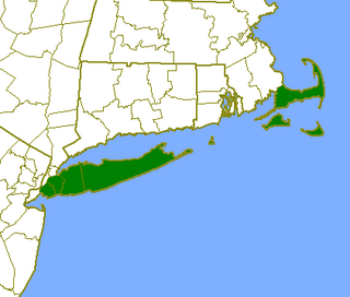
The Outer Lands is the prominent terminal moraine archipelagic region off the southern coast of New England in the United States. This eight-county region of Massachusetts, Rhode Island, and New York comprises the peninsula of Cape Cod and the islands of Nantucket, Martha's Vineyard, the Elizabeth Islands, Block Island, and Long Island, as well as surrounding islands and islets.

Craigville Beach is located on Nantucket Sound.

The Quashnet River, also known as Quoshnet River or Moonakis River, is a 5.1-mile-long (8.2 km) estuary in Falmouth, Massachusetts on Cape Cod. Its area is about 1-square-mile (2.6 km2).

Popponesset Bay System is a group of bays located at the towns of Mashpee and Barnstable (east), on Cape Cod, Massachusetts with a southern shore bounded by water from Nantucket Sound.
Popponesset Spit is a spit between Popponesset Bay and Nantucket Sound. The barrier peninsula extends for about 1.0 mile (1.6 km) from the community of Popponesset in Mashpee on Cape Cod in Massachusetts and is part of the coastline known as Popponesset Beach. The tip of the peninsula is owned by the Massachusetts Audubon Society while the landward end is owned by Save Popponesset Bay.

Hy-Line Cruises is an American family owned and operated Massachusetts ferry and cruise company. The company currently operates the second largest passenger ferry service between mainland Cape Cod and the islands of Martha's Vineyard and Nantucket. The company also operates sightseeing cruises and fishing charters. The company's main office is located at 22 Channel Point Road in Hyannis.
Wasque ("way-squee") or Wasque Beach is a 200-acre (0.81 km2) nature reserve on Chappaquiddick Island, Martha's Vineyard, Massachusetts. The site was established as a reservation for the public in 1967 and is one of five conservation areas on "the Vineyard" managed by the Trustees of Reservations. Wasque contains a sandy strand the Boston Globe calls "a magnificent beach." Travel + Leisure named Wasque Beach the number one beach in New England and WHDH-TV reports "It's pristine, serene, and rain or shine, it's a beach-goers' delight." Off the shore of Wasque Beach is Katama Bay, "a vast and pristine salt water bay that includes many acres of productive shellfish beds."

Scargo Tower is a 30-foot-tall (9.1 m) cobblestone tower located atop Scargo Hill in Dennis, Massachusetts on Cape Cod.
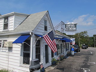
Four Seas Ice Cream is an independent ice cream shop located in Centerville, Massachusetts. It is one of the three oldest ice cream shops in New England. It has been the winner of many awards and citations over the years as the result of its flavors. In the past, it has been voted number seven on the list of Top 10 Ice Cream Parlors in the United States.

The geology of Massachusetts includes numerous units of volcanic, intrusive igneous, metamorphic and sedimentary rocks formed within the last 1.2 billion years. The oldest formations are gneiss rocks in the Berkshires, which were metamorphosed from older rocks during the Proterozoic Grenville orogeny as the proto-North American continent Laurentia collided against proto-South America. Throughout the Paleozoic, overlapping the rapid diversification of multi-cellular life, a series of six island arcs collided with the Laurentian continental margin. Also termed continental terranes, these sections of continental rock typically formed offshore or onshore of the proto-African continent Gondwana and in many cases had experienced volcanic events and faulting before joining the Laurentian continent. These sequential collisions metamorphosed new rocks from sediments, created uplands and faults and resulted in widespread volcanic activity. Simultaneously, the collisions raised the Appalachian Mountains to the height of the current day Himalayas.
Glacial Lake Nantucket Sound was a glacial lake that formed during the late Pleistocene epoch inside modern Nantucket Sound. After the Laurentide Ice Sheet retreated, glacial ice melt washed over the terminal moraine of Cape Cod and the glacial meltwater settled in the modern day sound, creating the lake.