Lake Cut Bank

Last updated
Lake Cut Bank
Eastern Portion of Glacier National Park (pg 104).jpg
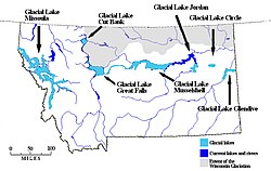
Glacial Lake Cut Bank, along the eastern edge of Glacier National Park.
USA Montana relief location map.jpg
Red pog.svg
Lake Cut Bank
Location Glacier, Montana along the Cut Bank Creek.
Coordinates 48°37′37″N112°21′15″W / 48.626910°N 112.354234°W / 48.626910; -112.354234 Coordinates: 48°37′37″N112°21′15″W / 48.626910°N 112.354234°W / 48.626910; -112.354234
Lake type Glacial lake (former)
Primary inflows Laurentide Ice Sheet
Primary outflows south along the ice front into Glacial Lake Choteau.
Basin  countries United States
Max. lengthabout 70 miles (110 km)
Max. width20 miles (32 km)
Surface area varied
Surface elevation3,900 m (12,800 ft)
References [1]

Lake Cut Bank was a glacial lake formed during the late Pleistocene along the Missouri and Sun Rivers. After the Laurentide Ice Sheet retreated, water melting off the glacier accumulated between the Rocky Mountinas and the ice sheet. The lake drained along the front of the ice sheet, eastward towards the Judith River and the Missouri River.

The front of the Keewatin ice sheet completely blocked the valley of Cut Bank Creek so that for 20 miles (32 km) the ice dam was bordered by the water of an extensive lake, which has been designated glacial Lake Cut Bank. [1] It is defined by the granitic pebbles and boulders on top of the hills southeast of Cut Bank and are present at several places in the basin farther north and west all below 4,000 feet (1,200 m). The pebbles were deposited from icebergs floating on the lake. The lake bottom is identified by the laminated silts over the flatter parts of the basin. The silts are up to 30 feet (9.1 m) as seen in some of the coulees. Additionally, stratified sand and gravel are visible in the basin. There is no defined shoreline. The lake has been mapped below 3,900 feet (1,200 m) contour, with shore like slopes between 3,900 and 4,000 feet (1,200 and 1,200 m). The Carlow Flat shows evidence of being submerged part of the time. About 8 metres (0.0080 km) southwest of Cut Bank the same granite pebbles are found at 4,050 feet (1,230 m). This is taken as the maximum and first lake level. The lake drained southward along the ice front. Later the water fell to 3,900 feet (1,200 m) and flowed through the sag occupied by ponds. [1]

The inner gorge of Cut Bank Creek formed after the glacial lake drained. The lake received runoff from the adjacent land area and from the north front of the Two Medicine Glacier for over 50 miles (80 km) (Squaw Buttes, southwest of Cut Bank, westward to the mountains). Cut Bank Glacier and the South Fork of the Milk River drained into Lake Cut Bank. [1] Water from the St. Mary Glacier and from both the mountain glaciers and the Keewatin ice sheet, north of the international boundary drained into the South Fork of the Milk River and then into glacial Lake Cut Bank. The glacial river channel is not abandoned. It runs form the Milk River northeast of Landslide Butte to the head of Rocky Coulee. [1] By assuming that each layer of the laminated clay deposited in this lake is a varve, representing one season's deposition, the longevity of the lake could be counted. [1]

Map of Montana showing Glacial Lake Cut Bank. Glacial lakes in Montana.jpg
Map of Montana showing Glacial Lake Cut Bank.

Related Research Articles

Lake Agassiz A very large glacial lake in central North America at the end of the last glacial period

Lake Agassiz was a very large glacial lake in central North America. Fed by glacial meltwater at the end of the last glacial period, its area was larger than all of the modern Great Lakes combined though its mean depth was not as great as that of many major lakes today.

Wisconsin glaciation North American glacial ice sheet

The Wisconsin Glacial Episode, also called the Wisconsin glaciation, was the most recent glacial period of the North American ice sheet complex. This advance included the Cordilleran Ice Sheet, which nucleated in the northern North American Cordillera; the Innuitian ice sheet, which extended across the Canadian Arctic Archipelago; the Greenland ice sheet; and the massive Laurentide Ice Sheet, which covered the high latitudes of central and eastern North America. This advance was synchronous with global glaciation during the last glacial period, including the North American alpine glacier advance, known as the Pinedale glaciation. The Wisconsin glaciation extended from approximately 75,000 to 11,000 years ago, between the Sangamonian Stage and the current interglacial, the Holocene. The maximum ice extent occurred approximately 25,000–21,000 years ago during the last glacial maximum, also known as the Late Wisconsin in North America.

Lake Missoula Prehistoric proglacial lake in Western Montana

Lake Missoula was a prehistoric proglacial lake in western Montana that existed periodically at the end of the last ice age between 15,000 and 13,000 years ago. The lake measured about 7,770 square kilometres (3,000 sq mi) and contained about 2,100 cubic kilometres (500 cu mi) of water, half the volume of Lake Michigan.

Glacial Lake Wisconsin was a prehistoric proglacial lake that existed from approximately 18,000 to 14,000 years ago, at the end of the last ice age, in the central part of present-day Wisconsin in the United States.

Pend Oreille River

The Pend Oreille River is a tributary of the Columbia River, approximately 130 miles (209 km) long, in northern Idaho and northeastern Washington in the United States, as well as southeastern British Columbia in Canada. In its passage through British Columbia its name is spelled Pend-d'Oreille River. It drains a scenic area of the Rocky Mountains along the U.S.-Canada border on the east side of the Columbia. The river is sometimes defined as the lower part of the Clark Fork, which rises in western Montana. The river drains an area of 66,800 square kilometres (25,792 sq mi), mostly through the Clark Fork and its tributaries in western Montana and including a portion of the Flathead River in southeastern British Columbia. The full drainage basin of the river and its tributaries accounts for 43% of the entire Columbia River Basin above the confluence with the Columbia. The total area of the Pend Oreille basin is just under 10% of the entire 258,000-square-mile (670,000 km2) Columbia Basin. Box Canyon Dam is currently underway on a multimillion-dollar project for a fish ladder.

Grand Coulee An ancient river bed in the U.S. state of Washington

The Grand Coulee is an ancient river bed in the U.S. state of Washington. This National Natural Landmark stretches for about 60 miles (100 km) southwest from Grand Coulee Dam to Soap Lake, being bisected by Dry Falls into the Upper and Lower Grand Coulee.

Laurentide Ice Sheet Continental glacier in North America during the last ice age

The Laurentide Ice Sheet was a massive sheet of ice that covered millions of square kilometers, including most of Canada and a large portion of the Northern United States, multiple times during the Quaternary glacial epochs, from 2.588 ± 0.005 million years ago to the present.

Dry Falls Scalloped precipice with four major alcoves, in central Washington scablands

Dry Falls is a 3.5-mile-long (5.6 km) scalloped precipice with four major alcoves, in central Washington scablands. This cataract complex is on the opposite side of the Upper Grand Coulee from the Columbia River, and at the head of the Lower Grand Coulee, northern end of Lenore Canyon. According to the current geological model, catastrophic flooding channeled water at 65 miles per hour through the Upper Grand Coulee and over this 400-foot (120 m) rock face at the end of the last glaciation. It is estimated that the falls were five times the width of Niagara, with ten times the flow of all the current rivers in the world combined.

Moses Coulee A canyon in the Waterville plateau region of Douglas County, Washington

Moses Coulee is a canyon in the Waterville plateau region of Douglas County, Washington. Moses Coulee is the second-largest and westernmost canyon of the Channeled Scablands, located about 30 kilometres (19 mi) to the west of the larger Grand Coulee. This water channel is now dry, but during glacial periods, large outburst floods with discharges greater than 600,000 m3/s (21,000,000 cu ft/s) carved the channel. While it's clear that megafloods from Glacial Lake Missoula passed through and contributed to the erosion of Moses Coulee, the origins of the coulee are less clear. Some researchers propose that floods from glacial Lake Missoula formed Moses Coulee, while others suggest that subglacial floods from the Okanogan Lobe incised the canyon. The mouth of Moses Coulee discharges into the Columbia River.

Withrow Moraine and Jameson Lake Drumlin Field

The Withrow Moraine and Jameson Lake Drumlin Field is a National Park Service–designated privately owned National Natural Landmark located in Douglas County, Washington state, United States. Withrow Moraine is the only Ice Age terminal moraine on the Waterville Plateau section of the Columbia Plateau. The drumlin field includes excellent examples of glacially-formed elongated hills.

Glacial history of Minnesota

The glacial history of Minnesota is most defined since the onset of the last glacial period, which ended some 10,000 years ago. Within the last million years, most of the Midwestern United States and much of Canada were covered at one time or another with an ice sheet. This continental glacier had a profound effect on the surface features of the area over which it moved. Vast quantities of rock and soil were scraped from the glacial centers to its margins by slowly moving ice and redeposited as drift or till. Much of this drift was dumped into old preglacial river valleys, while some of it was heaped into belts of hills at the margin of the glacier. The chief result of glaciation has been the modification of the preglacial topography by the deposition of drift over the countryside. However, continental glaciers possess great power of erosion and may actually modify the preglacial land surface by scouring and abrading rather than by the deposition of the drift.

Ice Age Floods National Geologic Trail

The Ice Age Floods National Geologic Trail or Ice Age Floods Trail is designated as the first National Geologic Trail in the United States. It will consist of a network of routes connecting facilities that will provide interpretation of the geological consequences of the Glacial Lake Missoula floods of the last glacial period that began about 110,000 years ago.

Shonkin Sag

The Shonkin Sag is a prehistoric fluvioglacial landform located along the northern edge of the Highwood Mountains in the state of Montana in the United States. The Sag is a river channel formed by the Missouri River and glacial meltwater pouring from Glacial Lake Great Falls. It is one of the most famous prehistoric meltwater channels in the world.

Lake Kankakee

Lake Kankakee formed 14,000 years before present (YBP) in the valley of the Kankakee River. It developed from the outwash of the Michigan Lobe, Saginaw Lobe, and the Huron-Erie Lobe of the Wisconsin glaciation. These three ice sheets formed a basin across Northwestern Indiana. It was a time when the glaciers were receding, but had stopped for a thousand years in these locations. The lake drained about 13,000 YBP, until reaching the level of the Momence Ledge. The outcropping of limestone created an artificial base level, holding water throughout the upper basin, creating the Grand Kankakee Marsh.

Lake Monongahela

Lake Monongahela was a proglacial lake in western Pennsylvania, West Virginia, and Ohio. It formed during the Pre-Illinoian ice epoch when the retreat of the ice sheet northwards blocked the drainage of these valleys to the north. The lake formed south of the ice front continued to rise until it was able to breach a low divide near New Martinsville, West Virginia. The overflow was the beginning of the process which created the modern Ohio River valley.

Lake Glendive

Glacial Lake Glendive was a glacial lake on the lower Yellowstone River. It formed in the valley of Yellowstone, during the late Pleistocene epoch south of the Keewatin Ice Sheet. As the ice sheet retreated northward, the lake drained into the modern Missouri River.

Lake Jordan (Montana)

Lake Jordan was a glacial lake formed during the late Pleistocene along the Jordan River. After the Laurentide Ice Sheet retreated, water melting off the glacier accumulated between the Rocky Mountains and the ice sheet. The lake drained along the front of the ice sheet, eastward towards the Yellowstone River and Glacial Lake Glendive.

Glacial Lake McKenzie

Before the Pleistocene Ice Age, circa two million years before present (YBP), the rivers in North, South Dakota and eastern Montana drained northeast into Canada and then into Hudson Bay. The Keewatin Lobe of the continental ice sheet, block the flow of water northward and impounded it along the ice front. Lakes formed, until the waters could find a new way to drain. Initially, the north flowing rivers followed the front of the glacier eastward and into a valley that passed between Garrison and Riverdale, to the Turtle Lake area, and on into Sheridan County. This is known as the preglacial McClean River. This valley became blocked by the glacier and the glacial lake identified as Lake McKenzie formed. Eventually, water level rose to crest the south ridge a point near Riverdale — at the site of the modern Garrison Dam and a diversion trench was cut. The modern Missouri River follows this pathway.

Lake Circle

Lake Circle was a glacial lake that formed during the late Pleistocene epoch along the Redwater River in eastern Montana. After the Laurentide Ice Sheet retreated, glacial ice melt accumulated in the basin surrounded by the ridges of the preglacial valley and the retreating glacier. Southwest of Nickwall are the remnants of a broad abandoned valley with long side slopes. The valley runs north from Redwater Creek to the Missouri River. The bottom is poorly drained and about 1 mile (1.6 km) in width. It lies 2,015 to 2,020 feet above the sea level and 40 to 50 feet above the Missouri River bottomland. The upland slopes are extensive, clear and flat. The valleys surrounding it are dissected with V-shaped coulees. The difference between the Redwater valley and those around it reflect stream erosion vs. lake sedimentation. The drift in the valleys, appears to be as left by the glacier in the previously created valleys. Using the dating of lake deposits near Great Falls, Montana, the Havre lobe of the Laurentide Ice Sheet dammed the ancestral Missouri River during the late Wisconsin Glacial Period.

Lake Chouteau

Lake Chouteau was a glacial lake formed during the late Pleistocene along the Teton River. After the Laurentide Ice Sheet retreated, water melting off the glacier accumulated between the Rocky Mountains and the ice sheet. The lake drained along the front of the ice sheet, eastward towards the Judith River and the Missouri River.

References

  1. 1 2 3 4 5 6 Physiography and Glacial Geology of Eastern Montana and Adjacent Areas; William C. Alden; United States Government Printing Office: Washington, D.C.; 1932

See also