Two Medicine

Last updated
Two Medicine Lake with Sinopah Mountain Two Medicine Lake.jpg
Two Medicine Lake with Sinopah Mountain

Two Medicine is the collective name of a region located in the southeastern section of Glacier National Park, in the U.S. state of Montana. It has a campground alongside Two Medicine Lake. From the period starting in the late 1890s until the completion of the Going-to-the-Sun Road in 1932, Two Medicine was one of the most visited sections of the park. Once part of a larger chalet complex, the Two Medicine Store is located along the shores of Two Medicine Lake and the building is a National Historic Landmark. The region is a starting point for many trails and tourboats take visitors out on Two Medicine Lake, where the steep south face of Rising Wolf Mountain towers above the lake. The region was considered sacred ground by several Native American tribes including the Blackfeet and they performed Vision quests here. Aside from Chief Mountain, the Two Medicine area is the most sacred section of the park to the Blackfeet.

From the Two Medicine Store, several hiking trails lead west and north from the area. Three lakes dominate the area, including Lower Two Medicine Lake, which is also on the Blackfeet Indian Reservation, Two Medicine Lake, which is the location of the campstore and the scenic boat rides, and Upper Two Medicine Lake which is a 4 miles (6.4 km) hike from the trailhead.
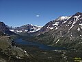
Related Research Articles

Glacier County, Montana U.S. county in Montana

Glacier County is located in the U.S. state of Montana. As of the 2010 United States Census, the population was 13,399. The county is located in northwestern Montana between the Great Plains and the Rocky Mountains, known to the Blackfeet as the "Backbone of the World". The county is geographically and culturally diverse and includes the Blackfeet Indian Reservation, Glacier National Park, and Lewis and Clark National Forest. The county is bordered by 75 miles of international boundary with two ports of entry open year-round and one seasonal international border crossing into Alberta, Canada.

Glacier National Park (U.S.) National park located in the U.S. state of Montana

Glacier National Park is an American national park located in northwestern Montana, on the Canada–United States border, adjacent to the Canadian provinces of Alberta and British Columbia. The park encompasses more than 1 million acres (4,000 km2) and includes parts of two mountain ranges, more than 130 named lakes, more than 1,000 different species of plants, and hundreds of species of animals. This vast pristine ecosystem is the centerpiece of what has been referred to as the "Crown of the Continent Ecosystem," a region of protected land encompassing 16,000 square miles (41,000 km2).

Blackfeet Nation Native American reservation in Montana

The Blackfeet Nation, officially named the Blackfeet Tribe of the Blackfeet Indian Reservation of Montana, is a federally recognized tribe of Siksikaitsitapi people with an Indian reservation in Montana. Tribal members primarily belong to the Piegan Blackfeet band of the larger Blackfoot Confederacy that spans Canada and the United States.

Lewis and Clark National Forest National Forest in Montana, United States

Lewis and Clark National Forest is located in west central Montana, United States. Spanning 2,912 square miles (7,500 km2), the forest is managed as two separate zones. The eastern sections, under the Jefferson Division, is a mixture of grass and shrublands dotted with "island" pockets of forested areas. Here, cattle leases to local ranchers as well as timber harvesting are the norm. The western Rocky Mountain Division, which straddles the Continental divide, is managed chiefly for environmental preservation, as much of the land has been designated as wilderness. Forest headquarters are located in Great Falls, Montana. Local ranger district offices have been established in Choteau, Harlowton, Neihart, Stanford, and White Sulphur Springs.

Logan Pass

Logan Pass is located along the Continental Divide in Glacier National Park, in the U.S. state of Montana. It is the highest point on the Going-to-the-Sun Road. The pass is named after Major Willian R. Logan, the first superintendent of the park.

Iceberg Cirque

The Iceberg Cirque is a large cirque that has been carved out by glaciation. It is located in Glacier National Park in the U.S. state of Montana. It is near Iceberg Lake in the Many Glacier section of the park, and can be approached by a hike starting at the Many Glacier Hotel.

Going-to-the-Sun Mountain

Going-to-the-Sun Mountain is located in Glacier National Park and rises dramatically above St. Mary Valley just north of the Going-to-the-Sun Road. The mountain was named by James Willard Schultz in 1888.

Bob Marshall Wilderness Complex

The Bob Marshall Wilderness Complex consists of three wilderness areas, all within the U.S. state of Montana totalling over 1.5 million acres (6,100 km²). The largest wilderness area is the Bob Marshall Wilderness Area consisting of 1 million acres (4000 km²). Adjoining the Bob Marshall to the north is the Great Bear Wilderness of 286,700 acres (1,160 km²), and to the south of the Bob Marshall is the Scapegoat Wilderness consisting of 239,936 acres (971 km²). An additional 1 million acres of roadless National Forest, private, and BLM land surrounds the designated wildernesses on all sides, for a total roadless area of 2.54 million acres.

Mission Mountains

The Mission Mountains or Mission Range are a range of the Rocky Mountains located in northwestern Montana in the United States. They lie chiefly in Lake County and Missoula County and are south and east of Flathead Lake and west of the Swan Range. On the east side of the range is the Swan River Valley and on the west side the Mission Valley.

Many Glacier

Many Glacier is an area within Glacier National Park which is located in the U.S. state of Montana. The Many Glacier region is located north of the Going-to-the-Sun Road, on the east side of the park. Lake Sherburne is the large lake in the area and the Many Glacier Hotel, the largest hotel within the park, is along the shore of the adjacent Swiftcurrent Lake. The Many Glacier Hotel and surrounding buildings are a National Historic Landmark, with original construction dating back to 1915. Many Glacier is surrounded by the high peaks of the Lewis Range, and numerous hiking trails can be accessed from the area. The region is noted for numerous lakes, waterfalls and dense coniferous forests interspersed with alpine meadows. Major sites in the immediate vicinity that can be accessed by trails include Lake Josephine, Grinnell Lake, Grinnell Glacier, Cracker Lake, Granite Park Chalet, Iceberg Cirque and the Ptarmigan Tunnel, which is a hiking tunnel carved through the mountainside during the 1930s. Tour boats allow visitors an opportunity to venture onto Swiftcurrent Lake. Other activities in the region include ranger guided nature hikes, horseback riding, fishing and camping.

St. Mary, Montana

St. Mary is an unincorporated community on the western border of the Blackfeet Indian Reservation adjacent to Glacier National Park in Glacier County, Montana, United States. The village is the eastern terminus of the Going-to-the-Sun Road which bisects the park east to west, a distance of 53 mi (85 km).

Highline Trail (Glacier National Park)

The Highline Trail is a scenic hiking trail in Glacier National Park, Montana, United States. The trail stretches 7.6 miles (12.2 km) from Logan Pass to Granite Park Chalet, and continues another 11.9 miles (19.2 km) from there to Fifty Mountain Campground. The trail follows the Garden Wall ridge and the continental divide for most of its length. The trail offers scenic views of glaciated U-shaped valleys. A 1.2-mile (1.9 km) round trip side trail takes hikers up the side of the Garden Wall to an overlook to Grinnell Glacier.

Sperry Glacier

Sperry Glacier is a glacier on the north slopes of Gunsight Mountain west of the Continental Divide in Glacier National Park in the U.S. state of Montana. Although many geologic features of Glacier National Park were formed during the much longer period of glaciation ending over 10,000 years ago, Sperry Glacier — like all the glaciers in the park today — is a product of the recent Little Ice Age, the period of cooler average temperatures starting in about the 13th century and concluding in the mid-19th century.

Indian Peaks Wilderness

The Indian Peaks Wilderness is a wilderness area in north central Colorado managed jointly by the United States Forest Service and the National Park Service within the Arapaho and Roosevelt National Forests and small parts of the southern section of Rocky Mountain National Park. It borders the James Peak Wilderness to the south, and straddles the Continental Divide. The area receives high visitation due to its proximity to the Denver metropolitan area.

Babb, Montana Census-designated place in Montana, United States

Babb is a small unincorporated farming and ranching community in Glacier County, Montana, United States, on the Blackfeet Indian Reservation. The community experiences a large influx of tourists in the summer months as it is the gateway to the Many Glacier area of Glacier National Park. Babb is a census-designated place (CDP) and had a population of 174 at the 2010 census.

Rising Wolf Mountain American mountain

Rising Wolf Mountain is located in the Lewis Range, Glacier National Park in the U.S. state of Montana. The peak is in the southeastern section of the park and rises dramatically above the Two Medicine region and more than 4,450 ft (1,360 m) above Two Medicine Lake immediately to the south. The Blackfeet consider the Two Medicine region of the park to be sacred ground and their name for the peak, "Mahkuyi-opuahsin", meaning, The way the wolf gets up, was later translated to the current name of the mountain.

James Willard Schultz American historian

James Willard Schultz, or Apikuni, was an American author, explorer, Glacier National Park guide, fur trader and historian of the Blackfeet Indians. He operated a fur trading post at Carroll, Montana 47°34′25″N108°22′24″W and lived among the Pikuni tribe during the period 1880-82. He was given the name Apikuni by the Pikuni chief, Running Crane. Apikuni in Blackfeet means "Spotted Robe." Schultz is most noted for his 37 books, most about Blackfoot life, and for his contributions to the naming of prominent features in Glacier National Park.

Regional designations of Montana Overview of the Regional designations of Montana

The Regional designations of Montana vary widely within the U.S state of Montana. The state is a large geographical area that is split by the Continental Divide, resulting in watersheds draining into the Pacific Ocean, Gulf of Mexico and Hudson's Bay. The state is approximately 545 miles (877 km) east to west along the Canada–United States border and 320 miles (510 km) north to south. The fourth largest state in land area, it has been divided up in official and unofficial ways into a variety of regions. Additionally, Montana is part of a number of larger federal government administrative regions.

Bierstadt Lake Lake in Colorado, United States

Bierstadt Lake is located in Larimer County, Colorado and within the Rocky Mountain National Park. Near McHenrys Peak and Longs Peak, there are "spectacular views" of the Continental Divide at the lake. The Bierstadt Lake Trailhead is located about 6.5 miles (10.5 km) from the turn-off at U.S. Route 36 into the Rocky Mountain National Park. During the summer, shuttle buses provide transportation to the trailhead.

References

    Coordinates: 48°29′11″N113°21′57″W / 48.4864°N 113.3659°W / 48.4864; -113.3659