
The Wisconsin Glacial Episode, also called the Wisconsin glaciation, was the most recent glacial period of the North American ice sheet complex. This advance included the Cordilleran Ice Sheet, which nucleated in the northern North American Cordillera; the Innuitian ice sheet, which extended across the Canadian Arctic Archipelago; the Greenland ice sheet; and the massive Laurentide Ice Sheet, which covered the high latitudes of central and eastern North America. This advance was synchronous with global glaciation during the last glacial period, including the North American alpine glacier advance, known as the Pinedale glaciation. The Wisconsin glaciation extended from approximately 75,000 to 11,000 years ago, between the Sangamonian Stage and the current interglacial, the Holocene. The maximum ice extent occurred approximately 25,000–21,000 years ago during the last glacial maximum, also known as the Late Wisconsin in North America.
In geology, a proglacial lake is a lake formed either by the damming action of a moraine during the retreat of a melting glacier, a glacial ice dam, or by meltwater trapped against an ice sheet due to isostatic depression of the crust around the ice. At the end of the last ice age about 10,000 years ago, large proglacial lakes were a widespread feature in the northern hemisphere.

The Laurentide Ice Sheet was a massive sheet of ice that covered millions of square miles, including most of Canada and a large portion of the Northern United States, multiple times during the Quaternary glacial epochs, from 2.588 ± 0.005 million years ago to the present.
The Bull Lake glaciation is the name of a glacial period in North America that is part of the Quaternary Ice Age. The Bull Lake glaciation began about 200,000 years ago and ended about 130,000 years ago, and was concurrent with the Illinoian Stage of the Quaternary Ice Age. There is disagreement over these time frames, however, and further research is necessary.

The Great Falls of the Missouri River are a series of waterfalls on the upper Missouri River in north-central Montana in the United States. From upstream to downstream, the five falls along a 10-mile (16 km) segment of the river are:
The Pre-Illinoian Stage is used by Quaternary geologists for the early and middle Pleistocene glacial and interglacial periods of geologic time in North America from ~2.5–0.2 Ma.
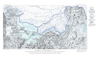
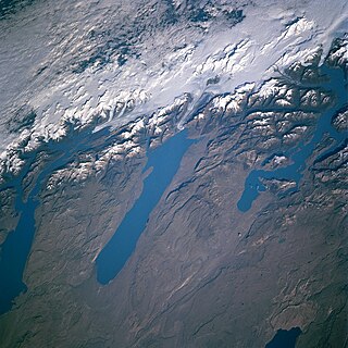
Lake Great Falls was a prehistoric proglacial lake which existed in what is now central Montana in the United States between 15,000 BCE and 11,000 BCE. Centered on the modern city of Great Falls, Montana, Glacial Lake Great Falls extended as far north as Cut Bank, Montana, and as far south as Holter Lake. At present-day Great Falls, the Glacial Lake Great Falls reached a depth of 600 feet.

The Shonkin Sag is a prehistoric fluvioglacial landform located along the northern edge of the Highwood Mountains in the state of Montana in the United States. The Sag is a river channel formed by the Missouri River and glacial meltwater pouring from Glacial Lake Great Falls. It is one of the most famous prehistoric meltwater channels in the world.

The Champlain Sea was a temporary inlet of the Atlantic Ocean, created by the retreating glaciers during the close of the last glacial period. The Sea once included lands in what are now the Canadian provinces of Quebec and Ontario, as well as parts of the American states of New York and Vermont.
Hill 57 is a sandstone-capped hill on the benchland northwest of Great Falls, Montana, United States. The origin of the name is in dispute, but probably derives from an advertisement for "Heinz 57" food products that was created on the hillside in the early 20th century. Hill 57 was home to a small and poverty-stricken community of Cree, Métis, and Ojibwe Native Americans from about the 1880s to the 1960s. Although much reduced in number, some of these landless Native Americans continue to reside on Hill 57. The extreme economic deprivation of Native Americans in the area led to the term "Hill 57" becoming a symbol and "a byword for urban Indian poverty". This community subsequently became the most widely cited example of "landless Indians" in Montana.
The Purcell Trench, also known as the Kootenay River Valley is a large valley on the western side of the northern part of North America's Rocky Mountains. The trench extends approximately 179 miles (288 km) from Lake Pend Oreille, Idaho, down the Kootenay River (north) to Kootenay Lake, up the north arm to Duncan Lake. It joins the Rocky Mountain Trench another 50 miles (80 km) northward at the south tip of Kinbasket Lake, in British Columbia. The trench bottom is 1 to 7 miles wide and is 1,750 to 2,100 feet above sea level. The trench is nearly a straight north or south line. Some of its topography has been carved into U-shaped glacial valleys, it is primarily a product of geologic faulting. The trench splits the Columbia Mountains between the Purcell Mountains on the east and the Selkirk Mountains on the west.

Glacial Lake Glendive was a glacial lake on the lower Yellowstone River. It formed in the valley of Yellowstone, during the late Pleistocene epoch south of the Keewatin Ice Sheet. As the ice sheet retreated northward, the lake drained into the modern Missouri River.

Lake Jordan was a glacial lake formed during the late Pleistocene along the Jordan River. After the Laurentide Ice Sheet retreated, water melting off the glacier accumulated between the Rocky Mountains and the ice sheet. The lake drained along the front of the ice sheet, eastward towards the Yellowstone River and Glacial Lake Glendive.
Lake Circle was a glacial lake that formed during the late Pleistocene epoch along the Redwater River in eastern Montana. After the Laurentide Ice Sheet retreated, glacial ice melt accumulated in the basin surrounded by the ridges of the preglacial valley and the retreating glacier. Southwest of Nickwall are the remnants of a broad abandoned valley with long side slopes. The valley runs north from Redwater Creek to the Missouri River. The bottom is poorly drained and about 1 mile (1.6 km) in width. It lies 2,015 to 2,020 feet above the sea level and 40 to 50 feet above the Missouri River bottomland. The upland slopes are extensive, clear and flat. The valleys surrounding it are dissected with V-shaped coulees. The difference between the Redwater valley and those around it reflect stream erosion vs. lake sedimentation. The drift in the valleys, appears to be as left by the glacier in the previously created valleys. Using the dating of lake deposits near Great Falls, Montana, the Havre lobe of the Laurentide Ice Sheet dammed the ancestral Missouri River during the late Wisconsin Glacial Period.
The basin that held Pleistocene Lake Musselshell is in the lower (north-flowing) reach of the river. It is underlain mostly by highly erodible Cretaceous Colorado shale, Montana group sandstone, siltstone and shale, and Hell Creek sandstone and shale. The bedrock is gently folded and affected by local faults and joints. There is a sequence of nine terraces and more than 100 glacial boulders. The terraces are older than the erratics as the erratics rest on the terraces.

Lake Cut Bank was a glacial lake formed during the late Pleistocene along the Missouri and Sun Rivers. After the Laurentide Ice Sheet retreated, water melting off the glacier accumulated between the Rocky Mountinas and the ice sheet. The lake drained along the front of the ice sheet, eastward towards the Judith River and the Missouri River.
Lake Chouteau was a glacial lake formed during the late Pleistocene along the Teton River. After the Laurentide Ice Sheet retreated, water melting off the glacier accumulated between the Rocky Mountains and the ice sheet. The lake drained along the front of the ice sheet, eastward towards the Judith River and the Missouri River.
The Keewatin ice sheet was a major ice sheet that periodically covered large parts of North America during glacial periods over the last ~2.6 million years. This included the following areas:
The Labrador ice sheet was a major ice sheet that periodically covered large parts of North America during glacial periods over the last ~2.6 million years. The seam between the two ice sheets passed over the northern tip of the Ugava Peninsula passing south across Hudson Bay and on to the Ontario shore near Fort Stevens. This seam continued southward across Lake Superior, east of the Keweenaw Peninsula of Michigan. Southward into Wisconsin, along the Lake Michigan shoreline, crossing into western Illinois. Reaching down the Mississippi River valley to its junction with the Missouri River, it reaches its most southern point. At this point, the ice sheet no longer abuts the Keewatin ice sheet.
