Riverdale, North Dakota

Last updated

Riverdale, North Dakota
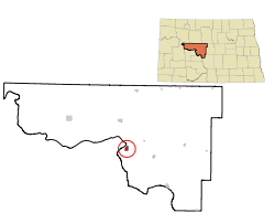
ND McLean County Riverdale.svg
Location of Riverdale, North Dakota
Coordinates: 47°29′51″N101°21′58″W / 47.49750°N 101.36611°W / 47.49750; -101.36611
CountryUnited States
State North Dakota
County McLean
FoundedSeptember 1985
Incorporated October 1985
Area
[1]
  Total1.39 sq mi (3.59 km2)
  Land1.39 sq mi (3.59 km2)
  Water0.00 sq mi (0.00 km2)
Elevation
[2]
1,962 ft (598 m)
Population
 (2020) [3]
  Total223
  Estimate 
(2022) [4]
223
  Density160.78/sq mi (62.06/km2)
Time zone UTC-6 (Central (CST))
  Summer (DST) UTC-5 (CDT)
ZIP code
58565
Area code 701
FIPS code 38-66980
GNIS feature ID1036239 [2]
Website riverdalenorthdakota.com

Riverdale is a town in McLean County, North Dakota, United States. The population was 223 at the 2020 census. [3]

Contents

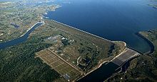
Riverdale was the largest of the construction camps that sprang up in 1946 to house workers building the Garrison Dam just to the west. After the dam was completed in 1953, residents of the other camps (including Dakota City and Big Bend) who decided to stay on relocated to Riverdale. It was operated by the federal government from its establishment until 1986, when it was turned over to the state of North Dakota with incorporation following shortly thereafter.

Geography

Garrison Dam, near Riverdale. U.S. Army Corps of Engineers, Garrison Project Headquarters are in Riverdale. Garrison Dam aerial.jpg
Garrison Dam, near Riverdale. U.S. Army Corps of Engineers, Garrison Project Headquarters are in Riverdale.

According to the United States Census Bureau, the city has a total area of 1.35 square miles (3.50 km2), all land. [5]

Demographics

Historical population
CensusPop.Note
1990 283
2000 273−3.5%
2010 205−24.9%
2020 2238.8%
2022 (est.)223 [4] 0.0%
U.S. Decennial Census [6]
2020 Census [3]

2010 census

As of the census of 2010, there were 205 people, 103 households, and 67 families residing in the city. The population density was 151.9 inhabitants per square mile (58.6/km2). There were 188 housing units at an average density of 139.3 per square mile (53.8/km2). The racial makeup of the city was 94.6% White, 2.9% Native American, 2.0% Asian, and 0.5% from two or more races.

There were 103 households, of which 11.7% had children under the age of 18 living with them, 61.2% were married couples living together, 2.9% had a female householder with no husband present, 1.0% had a male householder with no wife present, and 35.0% were non-families. 30.1% of all households were made up of individuals, and 10.7% had someone living alone who was 65 years of age or older. The average household size was 1.99 and the average family size was 2.40.

The median age in the city was 56.2 years. 9.8% of residents were under the age of 18; 3% were between the ages of 18 and 24; 14.6% were from 25 to 44; 48.7% were from 45 to 64; and 23.9% were 65 years of age or older. The gender makeup of the city was 50.7% male and 49.3% female.

2000 census

As of the census of 2000, there were 273 people, 108 households, and 84 families residing in the city. The population density was 195.1 inhabitants per square mile (75.3/km2). There were 157 housing units at an average density of 112.2 per square mile (43.3/km2). The racial makeup of the city was 96.34% White, 2.20% Native American, 0.73% Asian, and 0.73% from two or more races.

There were 108 households, out of which 27.8% had children under the age of 18 living with them, 75.9% were married couples living together, 0.9% had a female householder with no husband present, and 21.3% were non-families. 19.4% of all households were made up of individuals, and 5.6% had someone living alone who was 65 years of age or older. The average household size was 2.53 and the average family size was 2.86.

In the city, the population was spread out, with 22.7% under the age of 18, 4.4% from 18 to 24, 21.6% from 25 to 44, 31.5% from 45 to 64, and 19.8% who were 65 years of age or older. The median age was 46 years. For every 100 females, there were 103.7 males. For every 100 females age 18 and over, there were 113.1 males.

The median income for a household in the city was $48,333, and the median income for a family was $52,250. Males had a median income of $50,972 versus $27,500 for females. The per capita income for the city was $18,970. None of the families and 3.8% of the population were living below the poverty line, including no under eighteens and 5.7% of those over 64.
Climate

This climatic region is typified by large seasonal temperature differences, with warm to hot (and often humid) summers and cold (sometimes severely cold) winters. According to the Köppen Climate Classification system, Riverdale has a humid continental climate, abbreviated "Dfb" on climate maps. [7]

Climate data for Riverdale, North Dakota (1991–2020 normals, extremes 1948–present)
MonthJanFebMarAprMayJunJulAugSepOctNovDecYear
Record high °F (°C)56
(13)
65
(18)
87
(31)
92
(33)
97
(36)
99
(37)
105
(41)
105
(41)
105
(41)
95
(35)
78
(26)
61
(16)
105
(41)
Mean daily maximum °F (°C)20.2
(−6.6)
23.5
(−4.7)
36.7
(2.6)
52.3
(11.3)
65.1
(18.4)
74.1
(23.4)
80.7
(27.1)
79.9
(26.6)
71.1
(21.7)
53.8
(12.1)
37.4
(3.0)
24.7
(−4.1)
51.6
(10.9)
Daily mean °F (°C)11.7
(−11.3)
15.1
(−9.4)
27.3
(−2.6)
41.5
(5.3)
53.5
(11.9)
63.5
(17.5)
69.6
(20.9)
68.3
(20.2)
59.4
(15.2)
44.7
(7.1)
29.2
(−1.6)
18.1
(−7.7)
41.8
(5.4)
Mean daily minimum °F (°C)3.1
(−16.1)
6.7
(−14.1)
17.9
(−7.8)
30.7
(−0.7)
42.0
(5.6)
52.8
(11.6)
58.5
(14.7)
56.6
(13.7)
47.8
(8.8)
35.5
(1.9)
21.0
(−6.1)
11.4
(−11.4)
32.0
(0.0)
Record low °F (°C)−40
(−40)
−33
(−36)
−32
(−36)
−5
(−21)
12
(−11)
20
(−7)
34
(1)
34
(1)
16
(−9)
6
(−14)
−20
(−29)
−35
(−37)
−40
(−40)
Source: NOAA [8] [9]

Education

Riverdale High School was closed in the 1980s and consolidated with the high school in nearby Underwood, North Dakota.

Sports

The high school athletic teams were named the Knights and the school colors were red and white. The school fielded a nine-man football team. The team played local nine-man teams including Stanton, Goodrich, White Shield, Halliday, McClusky and Bowdon.

Related Research Articles

<span class="mw-page-title-main">Hettinger, North Dakota</span> City in North Dakota, United States

Hettinger is a city in, and the county seat of, Adams County, North Dakota, United States. The population was 1,074 at the 2020 census.

<span class="mw-page-title-main">Warwick, North Dakota</span> City in North Dakota, United States

Warwick is a city in Benson County, North Dakota, United States. The population was 55 at the 2020 census. Warwick was founded in 1907.

<span class="mw-page-title-main">Lansford, North Dakota</span> City in North Dakota, United States

Lansford is a city in Bottineau County, North Dakota, United States. The population was 238 at the 2020 census. Lansford was founded in 1903.

<span class="mw-page-title-main">Newburg, North Dakota</span> City in North Dakota, United States

Newburg is a city in Bottineau County, North Dakota, United States. The population was 96 at the 2020 census. Newburg was founded in 1906.

<span class="mw-page-title-main">Willow City, North Dakota</span> City in North Dakota, United States

Willow City is a city in Bottineau County, North Dakota, United States. The population was 149 at the 2020 census.

<span class="mw-page-title-main">Bowman, North Dakota</span> City in North Dakota, United States

Bowman is a city and county seat of Bowman County, North Dakota, United States. The population was 1,470 at the 2020 census.

<span class="mw-page-title-main">Scranton, North Dakota</span> City in North Dakota, United States

Scranton is a small town in Bowman County, North Dakota, United States. The population was 258 at the 2020 census.

<span class="mw-page-title-main">Crosby, North Dakota</span> City in North Dakota

Crosby is a city and the county seat of Divide County, North Dakota, United States. The population was 1,065 at the 2020 census.

<span class="mw-page-title-main">New Rockford, North Dakota</span> City in North Dakota, United States

New Rockford is a city in Eddy County, North Dakota, United States. It is the county seat of Eddy County. The population was 1,361 at the 2020 census. New Rockford was founded in 1883.

<span class="mw-page-title-main">McHenry, North Dakota</span> City in North Dakota, United States

McHenry is a city in Foster County, North Dakota, United States. The population was 64 at the 2020 census. McHenry was founded in 1899.

<span class="mw-page-title-main">Sentinel Butte, North Dakota</span> City in North Dakota, United States

Sentinel Butte is a city in Golden Valley County, North Dakota, United States. The population was 61 at the 2020 census.

<span class="mw-page-title-main">Wishek, North Dakota</span> City in North Dakota, United States

Wishek is a city in McIntosh County, North Dakota, United States. The population was 864 at the 2020 census.

<span class="mw-page-title-main">Hankinson, North Dakota</span> City in North Dakota, United States

Hankinson is a city in Richland County, North Dakota, United States. The population was 921 at the 2020 census. Hankinson was founded in 1886. It is part of the Wahpeton, ND–MN Micropolitan Statistical Area.

<span class="mw-page-title-main">Lidgerwood, North Dakota</span> City in North Dakota, United States

Lidgerwood is a city in Richland County, North Dakota, United States. The population was 600 at the 2020 census. Lidgerwood was founded in 1886. It is part of the Wahpeton, ND–MN Micropolitan Statistical Area.

<span class="mw-page-title-main">Adams, North Dakota</span> City in North Dakota, United States

Adams is a city in Walsh County, North Dakota, United States. The population was 127 at the 2020 census. Adams was founded in 1905.

<span class="mw-page-title-main">Park River, North Dakota</span> City in North Dakota, United States

Park River is a city in Walsh County, North Dakota, United States. The population was 1,424 at the 2020 census. Park River was founded in 1884.

<span class="mw-page-title-main">Kenmare, North Dakota</span> City in North Dakota, United States

Kenmare is a city in Ward County, North Dakota, United States. The population was 961 at the 2020 census. Kenmare is part of the Minot Micropolitan Statistical Area.

<span class="mw-page-title-main">Hurdsfield, North Dakota</span> City in North Dakota, United States

Hurdsfield is a city in Wells County, North Dakota, United States. The population was 64 at the 2020 census. Hurdsfield was founded in 1903.

<span class="mw-page-title-main">Wagner, South Dakota</span> City in South Dakota, United States

Wagner is a city in Charles Mix County, South Dakota, United States. The population was 1,490 at the 2020 census. The city is served by Wagner Municipal Airport as well as YST Transit buses.

<span class="mw-page-title-main">Parkston, South Dakota</span> City in South Dakota, United States

Parkston is a city in Hutchinson County, South Dakota, United States. The population was 1,567 at the 2020 census.

References

  1. "ArcGIS REST Services Directory". United States Census Bureau. Retrieved September 20, 2022.
  2. 1 2 U.S. Geological Survey Geographic Names Information System: Riverdale, North Dakota
  3. 1 2 3 "Explore Census Data". United States Census Bureau . Retrieved November 29, 2023.
  4. 1 2 "City and Town Population Totals: 2020-2022". United States Census Bureau. November 29, 2023. Retrieved November 29, 2023.
  5. "US Gazetteer files 2010". United States Census Bureau. Archived from the original on January 12, 2012. Retrieved June 14, 2012.
  6. United States Census Bureau. "Census of Population and Housing" . Retrieved July 19, 2013.
  7. Climate Summary for Riverdale, North Dakota
  8. "NowData - NOAA Online Weather Data". National Oceanic and Atmospheric Administration. Retrieved September 18, 2021.
  9. "Station: Riverdale, ND". U.S. Climate Normals 2020: U.S. Monthly Climate Normals (1991-2020). National Oceanic and Atmospheric Administration. Retrieved September 18, 2021.