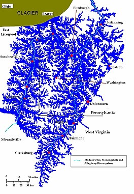
The Ohio River is a 981-mile (1,579 km) long river in the United States. It is located at the boundary of the Midwestern and Southern United States, flowing southwesterly from far-western Pennsylvania south of Lake Erie to its mouth on the Mississippi River at the southern tip of Illinois. It is the third largest river by discharge volume in the United States and the largest tributary by volume of the north-south flowing Mississippi River that divides the eastern from western United States. The river flows through or along the border of six states, and its drainage basin includes parts of 14 states. Through its largest tributary, the Tennessee River, the basin includes several states of the southeastern U.S. It is the source of drinking water for three million people.

The Allegheny River is a 325-mile (523 km) long headwater stream of the Ohio River in western Pennsylvania and New York, United States. The Allegheny River runs from its headwaters just below the middle of Pennsylvania's northern border northwesterly into New York then in a zigzag southwesterly across the border and through Western Pennsylvania to join the Monongahela River at the Forks of the Ohio on the "Point" of Point State Park in Downtown Pittsburgh, Pennsylvania. The Allegheny River is, by volume, the main headstream of both the Ohio and Mississippi Rivers. Historically, the Allegheny was considered to be the upper Ohio River by both Native Americans and European settlers.

The Monongahela River —often referred to locally as the Mon —is a 130-mile-long (210 km) river on the Allegheny Plateau in north-central West Virginia and southwestern Pennsylvania. The river flows from the confluence of its west and east forks in north-central West Virginia northeasterly into southwestern Pennsylvania, then northerly to Pittsburgh and its confluence with the Allegheny River to form the Ohio River. The river's entire length is navigable via a series of locks and dams.
Landforms are categorized by characteristic physical attributes such as their creating process, shape, elevation, slope, orientation, rock exposure, and soil type.

The Teays River (pronounced taze) was a major preglacial river that drained much of the present Ohio River watershed, but took a more northerly downstream course. Traces of the Teays across northern Ohio and Indiana are represented by a network of river valleys. The largest still existing contributor to the former Teays River is the Kanawha River in West Virginia, which is itself an extension of the New River. The name Teays from the Teays Valley is associated with this buried valley since 1910. The more appropriate name would be ancestral Kanawha Valley. The term Teays is used when discussing the buried portion of the ancestral Kanawha River. The Teays was comparable in size to the Ohio River. The River's headwaters were near Blowing Rock, North Carolina; it then flowed through Virginia, West Virginia, Ohio, Indiana and Illinois.. The largest tributary to the Teays River was the Old Kentucky River, which extended from southern Kentucky through Frankfort and subsequently flowed northeast, meeting other tributaries and eventually joining the Teays.

Western Pennsylvania is a region in the U.S. state of Pennsylvania, covering the western third of the state. Pittsburgh is the region's principal city, with a metropolitan area population of about 2.4 million people, and serves as its economic and cultural center. Erie, Altoona, and Johnstown are its other metropolitan centers. As of the 2010 census, Western Pennsylvania's total population is nearly 4 million.
The Maumee Torrent, also known as the Maumee Megaflood, was a catastrophic draining of Lake Maumee, the ancestor of present-day Lake Erie, that occurred approximately 14,000 to 17,000 years ago during the late Wisconsin glaciation. It happened when the waters of Lake Maumee, possibly in response to an advance of the ice front at the eastern end of the lake, overtopped a "sag" or low spot in the Fort Wayne Moraine, which was a deposit of glacial debris that acted as a natural dam at the site of present-day Fort Wayne, Indiana. This unleashed a massive flow of water that scoured a one- to two-mile-wide outlet running southwest to the Wabash River known as the "Wabash-Erie Channel", which probably followed the course of earlier, less massive drainage. The channel, now a small stream called the Little River, is the largest topographical feature in Allen County, Indiana. As much as 30 feet of fine sand, silt and organic sediments were deposited in the channel before drainage reversed and was captured by the present-day Maumee River. U.S. Route 24 between Fort Wayne and Huntington follows the channel.

Pittsburgh, surrounded by rivers and hills, has a unique transportation infrastructure that includes roads, tunnels, bridges, railroads, inclines, bike paths, and stairways.

A lacustrine plain or lake plain is a plain formed due to the past existence of a lake and its accompanying sediment accumulation. Lacustrine plains can be formed through one of three major mechanisms: glacial drainage, differential uplift, and inland lake creation and drainage. Lake plains can have various uses depending on where and how they form.

The geography of Pennsylvania varies from sea level marine estuary to mountainous plateau. It's significant for its natural resources and ports, and is notable for its role in the history of the United States.

Lake Tight, named for geologist William G. Tight, was a glacial lake in what is present-day Ohio, Kentucky, and West Virginia, during the Ice Age the early Pleistocene before 700 ka.

The glacial history of Minnesota is most defined since the onset of the last glacial period, which ended some 10,000 years ago. Within the last million years, most of the Midwestern United States and much of Canada were covered at one time or another with an ice sheet. This continental glacier had a profound effect on the surface features of the area over which it moved. Vast quantities of rock and soil were scraped from the glacial centers to its margins by slowly moving ice and redeposited as drift or till. Much of this drift was dumped into old preglacial river valleys, while some of it was heaped into belts of hills at the margin of the glacier. The chief result of glaciation has been the modification of the preglacial topography by the deposition of drift over the countryside. However, continental glaciers possess great power of erosion and may actually modify the preglacial land surface by scouring and abrading rather than by the deposition of the drift.

The Geology of Pennsylvania consists of six distinct physiographic provinces, three of which are subdivided into different sections. Each province has its own economic advantages and geologic hazards and plays an important role in shaping everyday life in the state. They are: the Atlantic Coastal Plain Province, the Piedmont Province, the New England Province, the Ridge and Valley Province, the Appalachian Plateau Province, and the Central Lowlands Province.

The Kankakee Outwash Plain is a flat plain interspersed with sand dunes in the Kankakee River valley in northwestern Indiana and northeastern Illinois of the United States. It is just south of the Valparaiso Moraine and was formed during the Wisconsin Glaciation. As the glacier, stopped at the Valparaiso Moraine, melted, the meltwater was carried away to the outwash plain. On the south side of the moraine, where the elevation drops, the meltwaters eroded away valleys, carrying sand and mud with them. As the muddy meltwater reached the valley where the slope lessened, the water slowed, depositing the sand on the outwash plain. This created a smooth, flat, and sandy plain. Before its draining, the Kankakee Marsh, located on the outwash plain, was one of the largest freshwater marshes in the United States.
The Prehistory of West Virginia spans ancient times until the arrival of Europeans in the early 17th century. Hunters ventured into West Virginia's mountain valleys and made temporary camp villages since the Archaic period in the Americas. Many ancient human-made earthen mounds from various mound builder cultures survive, especially in the areas of Moundsville, South Charleston, and Romney. The artifacts uncovered in these areas give evidence of a village society with a tribal trade system culture that included limited cold worked copper. As of 2009, over 12,500 archaeological sites have been documented in West Virginia.

Lake Kankakee formed 14,000 years before present (YBP) in the valley of the Kankakee River. It developed from the outwash of the Michigan Lobe, Saginaw Lobe, and the Huron-Erie Lobe of the Wisconsin glaciation. These three ice sheets formed a basin across Northwestern Indiana. It was a time when the glaciers were receding, but had stopped for a thousand years in these locations. The lake drained about 13,000 YBP, until reaching the level of the Momence Ledge. The outcropping of limestone created an artificial base level, holding water throughout the upper basin, creating the Grand Kankakee Marsh.

The Erie Plain is a lacustrine plain that borders Lake Erie in North America. From Buffalo, New York, to Cleveland, Ohio, it is quite narrow, but broadens considerably from Cleveland around Lake Erie to Southern Ontario, where it forms most of the Ontario peninsula. The Erie Plain was used in the United States as a natural gateway to the North American interior, and in both the United States and Canada the plain is heavily populated and provides very fertile agricultural land.

Blair Gap, one of the gaps of the Allegheny is a water gap along the eastern face atop the Allegheny Ridge or Allegheny Front escarpment. Like other 'gaps of the Allegheny' the slopes of Blair Gap were amenable to foot travel, pack mules, and possibly wagons allowing Amerindians, and then, after about 1778-1780 settlers, to travel west into the relatively depopulated Ohio Country decades before the railroads were born and tied the country together with steel. Historically, the gap was used for the upper sections of the Allegheny Portage Railroad, which as was authorized by the enabling acts in 1824 of Pennsylvania's Main Line of Public Works as part of the Pennsylvania Canal System which originally envisioned linking Pittsburgh to Philadelphia by canals. In the early 1900s, US Route 22 followed alongside the watercourse through the gap.

The gaps of the Allegheny, meaning gaps in the Allegheny Ridge in west-central Pennsylvania, is a series of escarpment eroding water gaps along the saddle between two higher barrier ridge-lines in the eastern face atop the Allegheny Ridge or Allegheny Front escarpment. The front extends south through Western Maryland and forms much of the border between Virginia and West Virginia, in part explaining the difference in cultures between those two post-Civil War states. While not totally impenetrable to daring and energetic travelers on foot, passing the front outside of the water gaps with even sure footed mules was nearly impossible without navigating terrain where climbing was necessary on slopes even burros would find extremely difficult.

The Portage Escarpment is a major landform in the U.S. states of Ohio, Pennsylvania, and New York which marks the boundary between the Till Plains to the north and west and the Appalachian Plateau to the east and south. The escarpment is the defining geological feature of New York's Finger Lakes region. Its proximity to Lake Erie creates a narrow but easily traveled route between upstate New York and the Midwest. Extensive industrial and residential development occurred along this route.