Proglacial lakes of Minnesota

Last updated
Present-day Minnesota, with proglacial lakes added in dark blue. Glacial lakes of Minnesota.GIF
Present-day Minnesota, with proglacial lakes added in dark blue.

The proglacial lakes of Minnesota were lakes created in what is now the U.S. state of Minnesota in central North America in the waning years of the last glacial period. As the Laurentide Ice Sheet decayed at the end of the Wisconsin glaciation, lakes were created in depressions or behind moraines left by the glaciers. Evidence for these lakes is provided by low relief topography and glaciolacustrine sedimentary deposits. [1] Not all contemporaneous, these glacial lakes drained after the retreat of the lobes of the ice sheets that blocked their outlets, or whose meltwaters fed them. There were a number of large lakes, one of which, Glacial Lake Agassiz, was the largest body of freshwater known to have existed on the North American continent; there were also dozens of smaller and more transitory lakes filled from glacial meltwater, which shrank or dried as the ice sheet retreated north.

Contents

Glacial Lake Agassiz

Glacial Lake Agassiz was an enormous lake, larger in area than all the Great Lakes combined, and the largest body of fresh water ever to have existed in North America. [2] It extended from its outlet near Browns Valley, Minnesota west into South Dakota and North Dakota and north into Saskatchewan, Manitoba, and Ontario. [2] In Minnesota the lake occupied the Red River Valley in northwestern Minnesota and the western part of the watershed of the Rainy River in the northern part of the state. [3] Its southern outlet was through the Traverse Gap, a spillway channel cut through the Big Stone Moraine by Glacial River Warren, [4] an enormous stream which carved the valley of the Minnesota River as well as that of the Upper Mississippi River below the confluence of those successor streams. [5] Lake Agassiz' present-day remnants include Lake of the Woods and Upper and Lower Red Lake. [6]

Glacial Lake Upham

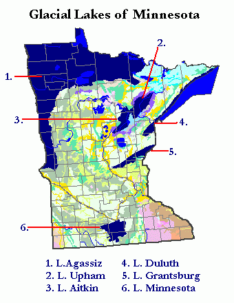
Glacial Lake Upham was formed in the wake of the retreat of the St. Louis Sublobe of the Des Moines Lobe. [7] It drained through a series of successively lower outlets to Glacial Lake Duluth. [8] Its former lake bed is now a broad boggy area comprising much of the watershed of the latter stream.

Glacial Lake Aitkin

Glacial Lake Aitkin was also a product of the recession of the St. Louis Sublobe, and for significant portions of its history was contiguous with Glacial Lake Upham. [7] It occupied a broad lowland along the valley of the present-day Mississippi River between Grand Rapids and Aitkin in north central Minnesota. The lake bed is now a sandy and clayey plain. [9] It is also a source for reed-sedge peat, which is harvested, processed, and packaged for agricultural applications; it enables plants to fix nitrogen and thereby reduces the need for fertilizer. The company harvesting the peat and the University of Minnesota-Duluth are developing processes to use the peat to extract mercury and other heavy metals, and also to remove sulfates from water by a method which enables the peat to be reused. [10]

Glacial Lake Duluth

Glacial Lake Duluth is the name given to the largest of a series of named lakes or lake stages occupying parts of the western Lake Superior basin. The name derives after a prominent terrace in the city of Duluth, along which Skyline Parkway was built, that was created by coastal erosion in Glacial Lake Duluth. As lower elevation outlets to the east was blocked by the Superior Lobe of the ice sheet, Lake Duluth drained through two outlets which crossed the present Laurentian Divide to the valleys of the Saint Croix River and the Mississippi. One outlet was a route from the western part of the lake through the Nemadji River basin and down the present Moose and Kettle Rivers; the other was via the modern Bois Brule River to the Saint Croix. [11] Glacial Lake Duluth's highest level was around 1060' in the city of Duluth, but rises as high as 1350' near the border with Ontario. When the glacier retreated the lake was able to drain to the east to the Lake Michigan basin via outlets across the upper Peninsula of Michigan.

Glacial Lake Grantsburg

Glacial Lake Grantsburg formed when the Grantsburg Sublobe of the Des Moines Lobe blocked southward drainage of the ice-free land to its north. It extended from St. Cloud east-northeast to Grantsburg, Wisconsin, whence its outflow ran south along the east front of the ice sheet down the valley of the Saint Croix River. [12]

Glacial Lake Minnesota

Glacial Lake Minnesota was a complex of lakes formed by or on the Des Moines Lobe generally south of Mankato, Minnesota. Evidence for it is found in lacustrine sediments in that region. [13] The lakes may have consisted of bodies of water trapped on the surface of the decaying ice sheet, [14] lakes created as the lobe retreated, [7] or depressions filled from the overflow of Glacial River Warren. [15]

See also

Related Research Articles

<span class="mw-page-title-main">Lake Agassiz</span> Large lake in central North America at the end of the last glacial period

Lake Agassiz was a large proglacial lake that existed in central North America during late Pleistocene, fed by meltwater from the retreating Laurentide Ice Sheet at the end of the last glacial period. At its peak, the lake's area was larger than all of the modern Great Lakes combined.

<span class="mw-page-title-main">St. Croix River (Wisconsin–Minnesota)</span> River in Wisconsin and Minnesota, United States

The St. Croix River is a tributary of the Mississippi River, approximately 169 miles (272 km) long, in the U.S. states of Wisconsin and Minnesota. The lower 125 miles (201 km) of the river form the border between Wisconsin and Minnesota. The river is a National Scenic Riverway under the protection of the National Park Service. A hydroelectric plant at the Saint Croix Falls Dam supplies power to the Minneapolis–St. Paul metropolitan area.

<span class="mw-page-title-main">Laurentide Ice Sheet</span> Continental glacier in North America during the last ice age

The Laurentide Ice Sheet was a massive sheet of ice that covered millions of square miles, including most of Canada and a large portion of the Northern United States, multiple times during the Quaternary glacial epochs, from 2.58 million years ago to the present.

<span class="mw-page-title-main">Lake Pepin</span> Lake in Minnesota and Wisconsin, US

Lake Pepin is a naturally occurring lake on the Mississippi River on the border between the U.S. states of Minnesota and Wisconsin. It is located in a valley carved by the outflow of an enormous glacial lake at the end of the last Ice Age. The lake formed when the Mississippi, a successor to the glacial river, was partially dammed by a delta from a tributary stream and spread out across the ancient valley.

<span class="mw-page-title-main">Savanna Portage State Park</span> United States historic place

Savanna Portage State Park is a state park of Minnesota, USA, established in 1961 to preserve the historic Savanna Portage, a difficult 6-mile (9.7 km) trail connecting the watersheds of the Mississippi River and Lake Superior. The portage trail crosses a drainage divide separating the West Savanna River, which drains to the Mississippi River and the Gulf of Mexico, from the East Savanna River, which flows in an opposite direction to the Saint Louis River, Lake Superior and the Great Lakes, and the Saint Lawrence River to the Atlantic Ocean.

<span class="mw-page-title-main">Superior National Forest</span> National forest in Minnesota, United States

Superior National Forest, part of the United States National Forest system, is located in the Arrowhead Region of the state of Minnesota between the Canada–United States border and the north shore of Lake Superior. The area is part of the greater Boundary Waters region along the border of Minnesota and the Canadian province of Ontario, a historic and important thoroughfare in the fur trading and exploring days of New France and British North America.

<span class="mw-page-title-main">Interstate Park</span> United States historic place

Interstate Park comprises two adjacent state parks on the Minnesota–Wisconsin border, both named Interstate State Park. They straddle the Dalles of the St. Croix River, a deep basalt gorge with glacial potholes and other rock formations. The Wisconsin park is 1,330 acres (538 ha) and the Minnesota park is 298 acres (121 ha). The towns of Taylors Falls, Minnesota and St. Croix Falls, Wisconsin are adjacent to the park. Interstate Park is within the Saint Croix National Scenic Riverway and the Ice Age National Scientific Reserve. The western terminus of the Ice Age National Scenic Trail is on the Wisconsin side. On the Minnesota side, two areas contain National Park Service rustic style buildings and structures that are listed on the National Register of Historic Places.

<span class="mw-page-title-main">Jay Cooke State Park</span> State park of Minnesota, United States

Jay Cooke State Park is a state park of Minnesota, United States, protecting the lower reaches of the Saint Louis River. The park is located about 10 miles (16 km) southwest of Duluth and is one of the ten most visited state parks in Minnesota. The western half of the park contains part of a rocky, 13-mile (21 km) gorge. This was a major barrier to Native Americans and early Europeans traveling by canoe, which they bypassed with the challenging Grand Portage of the St. Louis River. The river was a vital link connecting the Mississippi waterways to the west with the Great Lakes to the east.

<span class="mw-page-title-main">Lake Duluth</span> Former lake in North America

Lake Duluth was a proglacial lake that formed in the Lake Superior drainage basin as the Laurentide Ice Sheet retreated. The oldest existing shorelines were formed after retreat from the Greatlakean advance, sometime around 11,000 years B.P. Lake Duluth formed at the western end of the Lake Superior basin. Lake Duluth overflowed south through outlets in Minnesota and Wisconsin at an elevation of around 331 m above sea level.

<span class="mw-page-title-main">Lake Minong</span> Former lake in North America

Lake Minong was a proglacial lake that formed in the Lake Superior basin during the Wisconsin glaciation around 10,000 B.P. This was the last glacial advance that entered Michigan and covered only part of the upper peninsula. Lake Minong occurred in the eastern corner of the Lake Superior basin while Lake Duluth was in the western end. The lakes became separated when the glacier reached the upper peninsula. Lake Minong expanded to the north as the ice retreated after 9,800 B.P. When the ice retreated from the Keweenaw Peninsula, Lake Duluth merged into Lake Minong.

<span class="mw-page-title-main">Geology of Minnesota</span> Overview of the geology of the U.S. state of Minnesota

The geology of Minnesota comprises the rock, minerals, and soils of the U.S. state of Minnesota, including their formation, development, distribution, and condition.

<span class="mw-page-title-main">Geography of Minnesota</span> Overview of the geography of Minnesota

The U.S. State of Minnesota is the northernmost state outside Alaska; its isolated Northwest Angle in Lake of the Woods is the only part of the 48 contiguous states lying north of the 49th parallel north. Minnesota is in the U.S. region known as the Upper Midwest in interior North America. The state shares a Lake Superior water border with Michigan and Wisconsin on the northeast; the remainder of the eastern border is with Wisconsin. Iowa is to the south, South Dakota and North Dakota are to the west, and the Canadian provinces of Manitoba and Ontario are to the north. With 87,014 square miles (225,370 km2), or approximately 2.26% of the United States, Minnesota is the 12th largest state.

<span class="mw-page-title-main">Glacial history of Minnesota</span>

The glacial history of Minnesota is most defined since the onset of the last glacial period, which ended some 10,000 years ago. Within the last million years, most of the Midwestern United States and much of Canada were covered at one time or another with an ice sheet. This continental glacier had a profound effect on the surface features of the area over which it moved. Vast quantities of rock and soil were scraped from the glacial centers to its margins by slowly moving ice and redeposited as drift or till. Much of this drift was dumped into old preglacial river valleys, while some of it was heaped into belts of hills at the margin of the glacier. The chief result of glaciation has been the modification of the preglacial topography by the deposition of drift over the countryside. However, continental glaciers possess great power of erosion and may actually modify the preglacial land surface by scouring and abrading rather than by the deposition of the drift.

<span class="mw-page-title-main">Duluth Complex</span>

The Duluth Complex, the related Beaver Bay Complex, and the associated North Shore Volcanic Group are rock formations which comprise much of the basement bedrock of the northeastern part of the U.S. state of Minnesota in central North America. The Duluth and Beaver Bay complexes are intrusive rocks formed about 1.1 billion years ago during the Midcontinent Rift; these adjoin and are interspersed with the extrusive rocks of the North Shore Volcanic Group produced during that same geologic event. These formations are part of the Superior Upland physiographic region of the United States, which is associated with the Laurentian Upland of the Canadian Shield, the core of the North American Craton.

<span class="mw-page-title-main">Traverse Gap</span> River channel in Minnesota, US

The Traverse Gap is an ancient river channel occupied by Lake Traverse, Big Stone Lake and the valley connecting them at Browns Valley, Minnesota. It is located on the border of the U.S. states of Minnesota and South Dakota. Traverse Gap has an unusual distinction for a valley: it is crossed by a continental divide, and in some floods water has flowed across that divide from one drainage basin to the other. Before the Anglo-American Convention of 1818 it marked the border between British territory in the north and U.S. – or earlier, French – territory in the south.

Glacial River Warren, also known as River Warren, was a prehistoric river that drained Lake Agassiz in central North America between about 13,500 and 10,650 BP calibrated years ago. A part of the uppermost portion of the former river channel was designated a National Natural Landmark in 1966.

<span class="mw-page-title-main">River Warren Falls</span> Former waterfall in Minnesota, USA

The River Warren Falls was a massive waterfall on the glacial River Warren initially located in present-day Saint Paul, Minnesota, United States. The waterfall was 2700 feet (823 m) across and 175 feet (53 m) high.

The East Savanna River is a small yet historic stream in Aitkin and Saint Louis counties in the U.S. state of Minnesota. With a total length of 15.3 miles (24.6 km), the river rises in Wolf Lake, a small body of water within a spruce bog in Savanna Portage State Park, and flows northeasterly to the Saint Louis River at Floodwood, whence its waters flow to Lake Superior through the Great Lakes and the Saint Lawrence River to the Atlantic Ocean. A few thousand years ago the East Savanna was part of the Mississippi River itself, originating in northeast Minnesota and flowing southwesterly to Big Sandy Lake, from which the great river drained down its present valley to the Gulf of Mexico.

<span class="mw-page-title-main">North Shore Highlands</span>

The North Shore Highlands are a physiographic and ecological region of the U.S. state of Minnesota in central North America. They were formed by a variety of geologic processes, but are principally composed of rock created by magma and lava from a rift about 1.1 billion years ago, which rock formations are interspersed with and overlain by glacial deposits. Their ecology derives from these origins, with thin, rocky soils supporting flora and fauna typical of their northern, inland location.

<span class="mw-page-title-main">Lake Jordan (Montana)</span> Glacial lake (former) in Montana along the Jordan River , .

Lake Jordan was a glacial lake formed during the late Pleistocene along the Jordan River. After the Laurentide Ice Sheet retreated, water melting off the glacier accumulated between the Rocky Mountains and the ice sheet. The lake drained along the front of the ice sheet, eastward towards the Yellowstone River and Glacial Lake Glendive.

References

Notes

  1. Hudak et al., Landscape Suitability Models for Geologically Buried Precontact Cultural Resources Archived 2007-07-02 at the Wayback Machine , Glossary.
  2. 1 2 Waters, Streams and Rivers of Minnesota, p. 106.
  3. Waters, Streams and Rivers of Minnesota, p. 107.
  4. Sansome, Minnesota Underfoot, pp. 177-79.
  5. Ojakangas and Matsch, Minnesota's Geology, pp. 109-110.
  6. Ojakangas and Matsch, Minnesota's Geology, pp. 109.
  7. 1 2 3 Ojakangas and Matsch, Minnesota's Geology, p. 109.
  8. Waters, Streams and Rivers of Minnesota, pp. 26, 28-29.
  9. Sansome, Minnesota Underfoot, p. 155; Waters, Streams and Rivers of Minnesota, pp. 26, 211, 225.
  10. Martin Moylan, Minnesota firm tries an ancient solution to heavy metal pollution, Minnesota Public Radio News, April 9, 2019
  11. Waters, Streams and Rivers of Minnesota, pp. 28, 147.
  12. Ojakangas and Matsch, Minnesota's Geology, pp. 106-07, 212.
  13. Cooper, Soil Forming Factors Archived 2004-11-22 at the Wayback Machine .
  14. Ojakangas and Matsch, Minnesota's Geology, p. 226.
  15. Hudak and Hajic, Landscape Suitability Models for Geologically Buried Precontact Cultural Resources Archived 2007-07-24 at the Wayback Machine , section 12.3.4.1 (Landscapes: Paleo-Valley Landscape).

Sources