
The Mojave Desert is a desert in the rain shadow of the southern Sierra Nevada mountains and Transverse Ranges in the Southwestern United States. Named for the indigenous Mohave people, it is located primarily in southeastern California and southwestern Nevada, with small portions extending into Arizona and Utah.

The Mojave River is an intermittent river in the eastern San Bernardino Mountains and the Mojave Desert in San Bernardino County, California, United States. Most of its flow is underground, while its surface channels remain dry most of the time, except for the headwaters and several bedrock gorges in the lower reaches.

The Great Basin Desert is part of the Great Basin between the Sierra Nevada and the Wasatch Range. The desert is a geographical region that largely overlaps the Great Basin shrub steppe defined by the World Wildlife Fund, and the Central Basin and Range ecoregion defined by the U.S. Environmental Protection Agency and United States Geological Survey. It is a temperate desert with hot, dry summers and snowy winters. The desert spans large portions of Nevada and Utah, and extends into eastern California. The desert is one of the four biologically defined deserts in North America, in addition to the Mojave, Sonoran, and Chihuahuan Deserts.

The Amargosa River is an intermittent waterway, 185 miles (298 km) long, in southern Nevada and eastern California in the United States. The Amargosa River is one out of two rivers located in the California portion of the Mojave Desert with perennial flow. It drains a high desert region, the Amargosa Valley in the Amargosa Desert northwest of Las Vegas, into the Mojave Desert, and finally into Death Valley where it disappears into the ground aquifer. Except for a small portion of its route in the Amargosa Canyon in California and a small portion at Beatty, Nevada, the river flows above ground only after a rare rainstorm washes the region. A 26-mile (42 km) stretch of the river between Shoshone and Dumont Dunes is protected as a National Wild and Scenic River. At the south end of Tecopa Valley the Amargosa River Natural Area protects the habitat.

Lake Havasu is a large reservoir formed by Parker Dam on the Colorado River, on the border between San Bernardino County, California and Mohave County, Arizona. Lake Havasu City sits on the Arizonan side of the lake with its Californian counterpart of Havasu Lake directly across the lake. The reservoir has an available capacity of 619,400 acre-feet (0.7640 km3). The concrete arch dam was built by the United States Bureau of Reclamation between 1934 and 1938. The lake's primary purpose is to store water for pumping into two aqueducts. Prior to the dam construction, the area was home to the Mojave people. The lake was named after the Mojave word for blue. In the early 19th century, it was frequented by beaver trappers. Spaniards also began to mine the areas along the river.

The Mojave Road, also known as Old Government Road, is a historic route and present day dirt road across what is now the Mojave National Preserve in the Mojave Desert in the United States. This rough road stretched 147 miles (237 km) from Beale's Crossing, to Fork of the Road location along the north bank of the Mojave River where the old Mojave Road split off from the route of the Old Spanish Trail/Mormon Road.

The Cleghorn Lakes Wilderness is a 39,167-acre (158.50 km2) wilderness area in the southern Mojave Desert. It is located 16 miles (26 km) northeast of Twentynine Palms, California, and 20 miles (32 km) north of Joshua Tree National Park. It is managed by the Bureau of Land Management.
Lake Mojave is an ancient former lake fed by the Mojave River that, through the Holocene, occupied the Silver Lake and Soda Lake basins in the Mojave Desert of San Bernardino County, California. Its outlet may have ultimately emptied into the Colorado River north of Blythe.
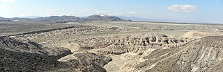
Lake Manix is a former lake fed by the Mojave River in the Mojave Desert. It lies within San Bernardino County, California. Located close to Barstow, this lake had the shape of a cloverleaf and covered four basins named Coyote, Cady/Manix, Troy and Afton. It covered a surface area of 236 square kilometres (91 sq mi) and reached an altitude of 543 metres (1,781 ft) at highstands, although poorly recognizable shorelines have been found at altitudes of 547–558 metres (1,795–1,831 ft). The lake was fed by increased runoff during the Pleistocene and overflowed into the Lake Mojave basin and from there to Lake Manly in Death Valley, or less likely into the Bristol Lake basin and from there to the Colorado River.
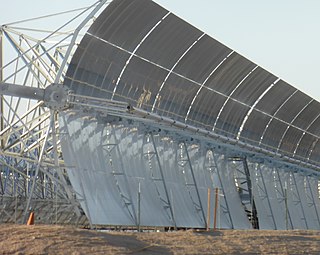
The Mojave Solar Project (MSP) is a concentrated solar power (CSP) facility in the Mojave Desert in California, about 20 miles (32 km) northwest of Barstow. Surrounding the hamlet of Lockhart, Mojave Solar is adjacent to Harper Lake and the SEGS VIII–IX solar plant.
The Rice Valley is a valley of the southeastern Mojave Desert, located within Riverside County, California.

Lake Cahuilla was a prehistoric lake in California and northern Mexico. Located in the Coachella and Imperial valleys, it covered surface areas of 5,700 km2 (2,200 sq mi) to a height of 12 m (39 ft) above sea level during the Holocene. During earlier stages of the Pleistocene, the lake reached even higher elevations, up to 31–52 m (102–171 ft) above sea level. During the Holocene most of the water came from the Colorado River with little contribution from local runoff; in the Pleistocene local runoff was higher and it is possible that Lake Cahuilla was supported solely from local water sources during the Wisconsin glaciation. The lake overflowed close to Cerro Prieto into the Rio Hardy, eventually draining into the Gulf of California.

Lake Manly was a pluvial lake in Death Valley, California. It forms occasionally in Badwater Basin after heavy rainfall, but at its maximum extent during the so-called "Blackwelder stand," ending approximately 120,000 years before present, the lake covered much of Death Valley with a surface area of 1,600 square kilometres (620 sq mi). Water levels varied through its history, and the chronology is further complicated by active tectonic processes that have modified the elevations of the various shorelines of Lake Manly; during the Blackwelder stage they reached 47–90 metres (154–295 ft) above sea level. The lake received water mainly from the Amargosa River and at various points from the Mojave River and Owens River. The lake and its substantial catchment favoured the spread of a number of aquatic species, including some lizards, pupfish and springsnails. The lake probably supported a substantial ecosystem, and a number of diatoms developed there.
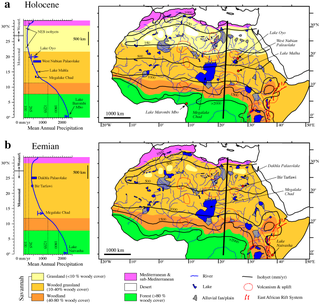
Lake Ptolemy is a former lake in Sudan. This lake formed during the Holocene in the Darfur region, during a time when the monsoon over Africa was stronger. The existence of the lake is dated between about 9,100–2,400 years before present. This lake could have reached a surface area of 30,750 square kilometres (11,870 sq mi), larger than present-day Lake Erie, although estimates of its size vary and it might have been much smaller. The shorelines in some places, insofar as they are recognizable, feature riparian landscapes and reeds. The lake was a freshwater lake replenished by groundwater and runoff from neighbouring mountains and might itself have been the source for the Nubian Sandstone Aquifer System. The lake featured a diverse ecosystem with a number of species, and possibly facilitated the spread of species between the Nile and Lake Chad.

Lake Suguta is a former lake in Africa. It formed in the Suguta Valley, which is part of the East African Rift, south of Lake Turkana during the Holocene African humid period.
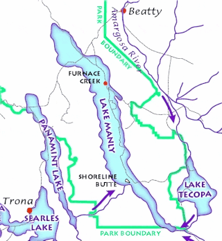
Lake Tecopa is a former lake in Inyo County, southern California. It developed during the Miocene and the Pleistocene within a tectonic basin close to the border with Nevada. Fed by the Amargosa River and some neighbouring washes, it eventually culminated to a surface area of 235 square kilometres (91 sq mi) around 186,000 years ago and left sediments. Afterwards, the Amargosa River cut a gorge out of the lake and into Death Valley with its Lake Manly, draining the lake. The present-day towns of Shoshone, California and Tecopa, California lie within the basin of the former lake.
Lake Tengger is a paleolake in China. It formed within the Tengger Desert during the Pleistocene and in reduced form during the Holocene as well. It is not certain when it existed.

Lake Panamint is a former lake that occupied Panamint Valley in California during the Pleistocene. It was formed mainly by water overflowing through the Owens River and which passed through Lake Searles into the Panamint Valley. At times, Lake Panamint itself overflowed into Death Valley and Lake Manly.

Laguna del Negro Francisco is a lake in the Atacama Region of Chile and the southernmost closed lake in the country. It is situated 200 kilometres (120 mi) northeast of the city of Copiapó. The lake is about 10 kilometres (6.2 mi) long and 4 kilometres (2.5 mi) wide with a surface area of about 20.7 square kilometres (8.0 sq mi) and a depth of about 1 metre. A peninsula, probably formed by a moraine and subsequently modified by wind-driven accumulation of sand, separates the lake into a north-northwesterly and a south-southeasterly half with different colour and water composition.

Lake Estancia was a lake formed in the Estancia Valley, central New Mexico, which left various coastal landforms in the valley. The lake was mostly fed by creek and groundwater from the Manzano Mountains, and fluctuated between freshwater stages and saltier stages. The lake had a diverse fauna, including cutthroat trout; they may have reached it during a possible past stage where it was overflowing.


