
The Wisconsin glaciation, also called the Wisconsin glacial episode, was the most recent glacial period of the North American ice sheet complex, peaking more than 20,000 years ago. This advance included the Cordilleran Ice Sheet, which nucleated in the northern North American Cordillera; the Innuitian ice sheet, which extended across the Canadian Arctic Archipelago; the Greenland ice sheet; and the massive Laurentide Ice Sheet, which covered the high latitudes of central and eastern North America. This advance was synchronous with global glaciation during the last glacial period, including the North American alpine glacier advance, known as the Pinedale glaciation. The Wisconsin glaciation extended from about 75,000 to 11,000 years ago, between the Sangamonian Stage and the current interglacial, the Holocene. The maximum ice extent occurred about 25,000–21,000 years ago during the last glacial maximum, also known as the Late Wisconsin in North America.

The Last Glacial Period (LGP), also known as the Last glacial cycle, occurred from the end of the Last Interglacial to the beginning of the Holocene, c. 115,000 – c. 11,700 years ago, and thus corresponds to most of the timespan of the Late Pleistocene.

The Laurentide ice sheet was a massive sheet of ice that covered millions of square miles, including most of Canada and a large portion of the Northern United States, multiple times during the Quaternary glacial epochs, from 2.58 million years ago to the present.

Okotoks Erratic is a 16,500-tonne (18,200-ton) boulder that lies on the otherwise flat, relatively featureless, surface of the Canadian Prairies in Alberta. It is part of the 930-kilometre-long (580 mi) Foothills Erratics Train of typically angular boulders of distinctive quartzite and pebbly quartzite.

A tunnel valley is a U-shaped valley originally cut under the glacial ice near the margin of continental ice sheets such as that now covering Antarctica and formerly covering portions of all continents during past glacial ages. They can be as long as 100 km (62 mi), 4 km (2.5 mi) wide, and 400 m (1,300 ft) deep.
The River Warren Falls was a massive waterfall on the glacial River Warren initially located in present-day Saint Paul, Minnesota, United States. The waterfall was 2700 feet (823 m) across and 175 feet (53 m) high.

The proglacial lakes of Minnesota were lakes created in what is now the U.S. state of Minnesota in central North America in the waning years of the last glacial period. As the Laurentide Ice Sheet decayed at the end of the Wisconsin glaciation, lakes were created in depressions or behind moraines left by the glaciers. Evidence for these lakes is provided by low relief topography and glaciolacustrine sedimentary deposits. Not all contemporaneous, these glacial lakes drained after the retreat of the lobes of the ice sheets that blocked their outlets, or whose meltwaters fed them. There were a number of large lakes, one of which, Glacial Lake Agassiz, was the largest body of freshwater known to have existed on the North American continent; there were also dozens of smaller and more transitory lakes filled from glacial meltwater, which shrank or dried as the ice sheet retreated north.
Lake Bassano was a proglacial lake that formed in the Late Pleistocene during the deglaciation of south-central Alberta by the impoundment of a re-established drainage system and addition of glacial meltwater. It is associated with the development of through-flowing drainage within the Red Deer River basin in particular, and the South Saskatchewan drainage network in general. Approximately 7,500 square kilometres (2,900 sq mi) of the Bassano basin is covered with lacustrine sediments. These sediments are bordered by the topographically higher Buffalo Lake Moraine to the west, the Suffield Moraine to the east and the Lethbridge Moraine to the south.
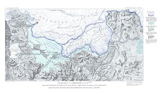
Lake Great Falls was a prehistoric proglacial lake which existed in what is now central Montana in the United States between 15,000 BCE and 11,000 BCE. Centered on the modern city of Great Falls, Montana, Glacial Lake Great Falls extended as far north as Cut Bank, Montana, and as far south as Holter Lake. At present-day Great Falls, the Glacial Lake Great Falls reached a depth of 600 feet.

The Shonkin Sag is a prehistoric fluvioglacial landform located along the northern edge of the Highwood Mountains in the state of Montana in the United States. The Sag is a river channel formed by the Missouri River and glacial meltwater pouring from Glacial Lake Great Falls. It is one of the most famous prehistoric meltwater channels in the world.

The Kankakee Torrent was a catastrophic flood that occurred about 19,000 calibrated years ago in the Midwestern United States. It resulted from a breach of moraines forming a large glacial lake fed by the melting of the Late Wisconsin Laurentide Ice Sheet. The point of origin of the flood was Lake Chicago. The landscape south of Chicago still shows the effects of the torrent, particularly at Kankakee River State Park and on the Illinois River at Starved Rock State Park.

The Vashon Glaciation, Vashon Stadial or Vashon Stade is a local term for the most recent period of very cold climate in which during its peak, glaciers covered the entire Salish Sea as well as present day Seattle, Tacoma, Olympia and other surrounding areas in the western part of present-day Washington (state) of the United States of America. This occurred during a cold period around the world known as the last glacial period. This was the most recent cold period of the Quaternary glaciation, the time period in which the arctic ice sheets have existed. The Quaternary Glaciation is part of the Late Cenozoic Ice Age, which began 33.9 million years ago and is ongoing. It is the time period in which the Antarctic ice cap has existed.

Glacial Lake Glendive was a glacial lake on the lower Yellowstone River. It formed in the valley of Yellowstone, during the late Pleistocene epoch south of the Keewatin Ice Sheet. As the ice sheet retreated northward, the lake drained into the modern Missouri River.

Lake Jordan was a glacial lake formed during the late Pleistocene along the Jordan River. After the Laurentide Ice Sheet retreated, water melting off the glacier accumulated between the Rocky Mountains and the ice sheet. The lake drained along the front of the ice sheet, eastward towards the Yellowstone River and Glacial Lake Glendive.
Before the Pleistocene Ice Age, circa two million years before present (YBP), the rivers in North, South Dakota and eastern Montana drained northeast into Canada and then into Hudson Bay. The Keewatin Lobe of the continental ice sheet, block the flow of water northward and impounded it along the ice front. Lakes formed, until the waters could find a new way to drain. Initially, the north flowing rivers followed the front of the glacier eastward and into a valley that passed between Garrison and Riverdale, to the Turtle Lake area, and on into Sheridan County. This is known as the preglacial McClean River. This valley became blocked by the glacier and the glacial lake identified as Lake McKenzie formed. Eventually, water level rose to crest the south ridge a point near Riverdale — at the site of the modern Garrison Dam and a diversion trench was cut. The modern Missouri River follows this pathway.
The basin that held Pleistocene Lake Musselshell is in the lower (north-flowing) reach of the river. It is underlain mostly by highly erodible Cretaceous Colorado shale, Montana group sandstone, siltstone and shale, and Hell Creek sandstone and shale. The bedrock is gently folded and affected by local faults and joints. There is a sequence of nine terraces and more than 100 glacial boulders. The terraces are older than the erratics as the erratics rest on the terraces.

Lake Cut Bank was a glacial lake formed during the late Pleistocene along the Missouri and Sun Rivers. After the Laurentide Ice Sheet retreated, water melting off the glacier accumulated between the Rocky Mountinas and the ice sheet. The lake drained along the front of the ice sheet, eastward towards the Judith River and the Missouri River.
Lake Chouteau was a glacial lake formed during the late Pleistocene along the Teton River. After the Laurentide Ice Sheet retreated, water melting off the glacier accumulated between the Rocky Mountains and the ice sheet. The lake drained along the front of the ice sheet, eastward towards the Judith River and the Missouri River.
The Keewatin ice sheet was a major ice sheet that periodically covered large parts of North America during glacial periods over the last ~2.6 million years. This included the following areas:

