
Concord is the capital city of the U.S. state of New Hampshire and the seat of Merrimack County. As of the 2020 census the population was 43,976, making it the third largest city in New Hampshire behind Manchester and Nashua.
Madison is a town in Carroll County, New Hampshire, United States. The population was 2,565 at the 2020 census. Madison includes the village of Silver Lake and the village district of Eidelweiss.

Franklin is a city in Merrimack County, New Hampshire, United States. At the 2020 census, the population was 8,741, the least of New Hampshire's 13 cities. Franklin includes the village of West Franklin.

South Hooksett is a census-designated place (CDP) within the town of Hooksett in Merrimack County, New Hampshire, United States. The population was 5,888 at the 2020 census. It is a suburban area adjacent to the city of Manchester, New Hampshire's largest city, and includes a mix of housing developments and large retail stores.

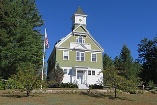
Sutton is a town in Merrimack County, New Hampshire, United States. The population was 1,978 at the 2020 census. Sutton includes the villages of Sutton Mills, North Sutton, South Sutton and East Sutton. North Sutton is home to Wadleigh State Park on Kezar Lake.
Tilton Northfield is a census-designated place (CDP) representing two adjacent villages in the towns of Tilton in Belknap County and Northfield in Merrimack County in the U.S. state of New Hampshire. The CDP encompasses the town centers of both Tilton and Northfield, located on either side of the Winnipesaukee River. The population was 3,324 at the 2020 census.

The Dartmouth–Lake Sunapee area of the U.S. state of New Hampshire lies in the west-central portion of the state, along the Connecticut River Valley. It includes all of Sullivan County, and parts of Merrimack County and Grafton County. The region shares its name with Dartmouth College, a prestigious Ivy League institution, and Lake Sunapee, a popular tourist destination. Interstate 89 forms the main freeway connecting the region to other parts of New Hampshire, as well as to nearby Vermont. Lebanon, Hanover, and Claremont are the three most populous communities in the region.

Lake Hitchcock was a glacial lake that formed approximately 15,000 years ago in the late Pleistocene epoch. After the Laurentide Ice Sheet retreated, glacial ice melt accumulated at the terminal moraine and blocked up the Connecticut River, creating the long, narrow lake. The lake existed for approximately 3,000 years, after which a combination of erosion and continuing geological changes likely caused it to drain. At its longest, Lake Hitchcock stretched from the moraine dam at present-day Rocky Hill, Connecticut, to St. Johnsbury, Vermont. Although the rift valley through which the river flows above Rocky Hill actually continues south to New Haven, on Long Island Sound, the obstructing moraine at Rocky Hill diverted the river southeast to its present mouth at Old Saybrook.
As part of New England, Connecticut has undergone much geologic change shaped by plate tectonics, volcanism, and glacial activity.

The Amoskeag Falls are a set of waterfalls on the Merrimack River in Manchester, New Hampshire, United States.

Baboosic Lake (buh-BOO-sik) is a 228.5-acre (92.5 ha) lake on the border of the towns of Amherst and Merrimack, in New Hampshire. The lake drains into Baboosic Brook, a tributary of the Merrimack River.

The northern boundary of the U.S. state of Massachusetts adjoins two other states: Vermont and New Hampshire. The majority of the boundary is roughly a straight line from the northwest corner of the state east to a point in Dracut, just north of Lowell. East of that point, the border is a series of line segments about 3 miles (5 km) north of the curving Merrimack River, ending in the Atlantic Ocean.
New Hampshire's 2nd congressional district covers the western, northern, and some southern parts of New Hampshire. It includes the state's second-largest city, Nashua, as well as the state capital, Concord. It is currently represented in the United States House of Representatives by Democrat Ann McLane Kuster.

Lake Sunapee is located within Sullivan County and Merrimack County in western New Hampshire, the United States. It is the fifth-largest lake located entirely in New Hampshire.
Glacial Lake Albany was a prehistoric North American proglacial lake that formed during the end of the Wisconsinan glaciation. It existed between 15,000 and 12,600 years ago and was created when meltwater from a retreating glacier, along with water from rivers such as the Iromohawk, became ice dammed in the Hudson Valley. Organic materials in Lake Albany deposits have been carbon dated to approximately 11,700 years ago. The lake spanned approximately 160 miles (260 km) from present-day Poughkeepsie to Glens Falls.
Lake Vermont, also called Glacial Lake Vermont, was a temporary lake created by the retreating glaciers during the close of the last ice age. The lake once included land in the Canadian province of Quebec and the American states Vermont and New York. It was a geographical predecessor of Lake Champlain. Once the glacier retreated far enough north, it drained into Glacial Lake Candona, the geologic predecessor of the St. Lawrence River.
Lake Stowe was a glacial lake that formed in Central Vermont approximately 15,000 years ago in the late Pleistocene epoch. After the Laurentide Ice Sheet retreated, glacial ice melt accumulated at the terminal moraine.

Blackwater Dam is a dam in the town of Webster, Merrimack County, New Hampshire.

Pennichuck Brook is one of the tributaries of the Merrimack River in New Hampshire in the United States. Its watershed is 31 square miles (80 km2) and is one of the 14 subwatersheds of the Merrimack River. It passes through Nashua and Merrimack, New Hampshire and serves as the public water supply for greater Nashua.
