Yoldia Sea

Last updated

Yoldia Sea is a name given by geologists to a variable brackish water stage in the Baltic Sea basin that prevailed after the Baltic Ice Lake was drained to sea level during the Weichselian glaciation. Dates for the Yoldia sea are obtained mainly by radiocarbon dating material from ancient sediments and shore lines and from clay-varve chronology. They tend to vary by as much as a thousand years, but a good estimate is 10,300 – 9500 radiocarbon years BC, equivalent to ca 11,700–10,700 calendar years BC. The sea ended gradually when isostatic rise of Scandinavia closed or nearly closed its effluents, altering the balance between saline and fresh water. The Yoldia Sea became Ancylus Lake. The Yoldia Sea stage had three phases of which only the middle phase had brackish water.

The name of the sea is adapted from the obsolete name of the bivalve, Portlandia arctica (previously known as Yoldia arctica), found around Stockholm. This bivalve requires cold saline water. It characterizes the middle phase of the Yoldia Sea, during which saline water poured into the Baltic, before the acceleration of glacial melting.

Description

Post-glacial sea level, combined with isostatic rebound, resulted in a sequence of Baltic lakes and seas. Post-Glacial Sea Level.png
Post-glacial sea level, combined with isostatic rebound, resulted in a sequence of Baltic lakes and seas.

The Baltic Ice Lake, the Yoldia Sea, the Ancylus Lake and the Littorina Sea are four recognized stages in the postglacial progression of the Baltic basin – there are also transition periods which can be considered as substages. [1] From earliest to most recent they run:

  • The Mastogloia Sea – a substage sometimes used to distinguish the period between 8000 and 7000 years ago when the Baltic became distinctly brackish – during this period the English Channel and the Danish straits circulation was established, increasing Atlantic water inflow.
  • The Limnea Sea – a substage sometimes used to distinguish the transition of the Baltic Sea to a more stagnant phase, which currently exists – about 2,500 B.C. [1]

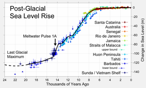
The Baltic Ice Lake came to an end when it overflowed through central Sweden and drained, a process complete by about 10,300 B.C. (radiocarbon years). The straits through the present Stockholm region (via Lake Vänern and the Strait of Närke) to the Atlantic were the only outlet at that time. When lake level reached sea level the difference in salinity caused a backflow from the North Sea, creating saline regions in which the marine bivalve Yoldia flourished. This phase lasted until about 10,000 B.C.. [3]

Subsequently, increased melting of the glacier provided additional fresh water and the lake became stratified (meromictic), with salt water on the bottom and fresh on top. Over the life of the sea and from location to location the salinity was a variable. Whether it is possible to speak of stages of salinity that would apply uniformly to the whole sea is debatable. [3]

At about 10,000 B.C., the exit continued to rise and the lake/sea broke through Denmark creating the first Great Belt channels. The total opening was less than 1 km wide and included two channels at the northern end. The Great Belt channels was blocked again by rising land from the post-glacial rebound that created Ancylus Lake. [3]

Geographically, the Gulf of Bothnia remained under the ice. The Gulf of Finland was open but most of Finland was an archipelago, over which debris carried by glacial streams gradually spread. A land bridge joined Germany to southern Sweden through Denmark. Relieved of its weight of ice, Finland rose gradually and unevenly from the sea. Parts of the Yoldia shoreline are above sea level today while other parts remain below. The Yoldia Sea toward its end was about 30m below current sea level. A channel at the location of the Neva River connected Yoldia Sea to Lake Ladoga. [3]

The Yoldia Sea existed entirely within the Boreal Blytt–Sernander period. The forests and species lining its shores were boreal. Mesolithic cultures continued to occupy Denmark/south Sweden and the southern shores of the sea. The sea as an ecologic system came to an end when Scandinavia rose sufficiently to block the flow through the Stockholm area and the saline balance shifted toward a lacustrine ecology once again. [3]

Related Research Articles

<span class="mw-page-title-main">Baltic Sea</span> Sea in Northern Europe

The Baltic Sea is an arm of the Atlantic Ocean that is enclosed by Denmark, Estonia, Finland, Germany, Latvia, Lithuania, Poland, Russia, Sweden, and the North and Central European Plain.

<span class="mw-page-title-main">Lake Ladoga</span> Freshwater lake in Russia

Lake Ladoga is a freshwater lake located in the Republic of Karelia and Leningrad Oblast in northwestern Russia, in the vicinity of Saint Petersburg.

<span class="mw-page-title-main">Vänern</span> Largest lake in Sweden

Vänern is the largest lake in Sweden, the largest lake in the European Union and the third-largest lake in Europe after Ladoga and Onega in Russia. It is located in the provinces of Västergötland, Dalsland, and Värmland in the southwest of the country. With its surface located at 44 metres (144 ft) with a maximum depth of 106 metres (348 ft), the lowest point of the Vänern basin is at 62 metres (203 ft) below sea level. The average depth is at a more modest 28 metres (92 ft), which means that the average point of the lake floor remains above sea level.

<span class="mw-page-title-main">Øresund</span> Strait between Denmark and Sweden

Øresund or Öresund, commonly known in English as the Sound, is a strait which forms the Danish–Swedish border, separating Zealand (Denmark) from Scania (Sweden). The strait has a length of 118 kilometres (73 mi); its width varies from 4 kilometres (2.5 mi) to 28 kilometres (17 mi). It is 4 kilometres (2.5 mi) wide at its narrowest point between Helsingør in Denmark and Helsingborg in Sweden.

<span class="mw-page-title-main">Great Belt</span> Strait in Denmark linking the Baltic Sea to the Kattegat strait and the Atlantic Ocean

The Great Belt is a strait between the major islands of Zealand (Sjælland) and Funen (Fyn) in Denmark. It is one of the three Danish Straits.

In geomorphology, an outburst flood—a type of megaflood—is a high-magnitude, low-frequency catastrophic flood involving the sudden release of a large quantity of water. During the last deglaciation, numerous glacial lake outburst floods were caused by the collapse of either ice sheets or glaciers that formed the dams of proglacial lakes. Examples of older outburst floods are known from the geological past of the Earth and inferred from geomorphological evidence on Mars. Landslides, lahars, and volcanic dams can also block rivers and create lakes, which trigger such floods when the rock or earthen barrier collapses or is eroded. Lakes also form behind glacial moraines or ice dams, which can collapse and create outburst floods.

<span class="mw-page-title-main">Varve</span> Annual layer of sediment or sedimentary rock

A varve is an annual layer of sediment or sedimentary rock.

<span class="mw-page-title-main">Degerfors</span> Locality in Värmland, Sweden

Degerfors is a locality and the seat of Degerfors Municipality, Örebro County, Sweden, with 7,160 inhabitants in 2010. Degerfors is the sixth-largest city in Örebro County. It is located at the southern shore of lake Möckeln, 13 km south of neighboring Karlskoga.

<span class="mw-page-title-main">Scandinavian prehistory</span>

The Scandinavian Peninsula became ice-free around the end of the last ice age. The Nordic Stone Age begins at that time, with the Upper Paleolithic Ahrensburg culture, giving way to the Mesolithic hunter-gatherers by the 7th millennium BC. The Neolithic stage is marked by the Funnelbeaker culture, followed by the Pitted Ware culture.

<span class="mw-page-title-main">Littorina Sea</span>

Littorina Sea is a geological brackish water stage of the Baltic Sea, which existed around 7500–4000 BP and followed the Mastogloia Sea, a transitional stage of the Ancylus Lake.

<span class="mw-page-title-main">Eemian Sea</span> Body of water existing over 100,000 years ago near the modern Baltic Sea

The Eemian Sea was a body of water located approximately where the Baltic Sea is now during the last interglacial, or Eemian Stage, Marine isotopic stage (MIS) 5e, roughly 130,000 to 115,000 years BP. Sea level was 5 to 7 metres higher globally than it is today, due to the release of glacial water in the early stage of the interglacial. Although "Eemian" rightly applies only to the northern European glacial system, some scientists use the term in a wider sense to mean any high-level body of water in the last interglacial.

<span class="mw-page-title-main">Baltic Ice Lake</span> Prehistoric freshwater lake in the Baltic Sea basin formed from receding glaciers

The Baltic Ice Lake is a name given by geologists to a freshwater lake that evolved in the Baltic Sea basin as glaciers retreated from that region at the end of the last ice age. The lake existed between 12,600 and 10,300 years Before Present (BP).

Ancylus Lake is a name given by geologists to a large freshwater lake that existed in northern Europe approximately from 9500 to 8000 years BC being in effect one of various predecessors to the modern Baltic Sea.

The Mastogloia Sea is one of the prehistoric stages of the Baltic Sea in its development after the last ice age. This took place c. 8000 years ago following the Ancylus Lake stage and preceding the Littorina Sea stage.

<span class="mw-page-title-main">Pulli settlement</span> Oldest known human settlement in Estonia

Pulli settlement, located on the right bank of the Pärnu River, is the oldest known human settlement in Estonia. It is two kilometers from the town of Sindi, which is 14 kilometers from Pärnu. According to radiocarbon dating, Pulli was settled around 11,000 years ago, at the beginning of the 9th millennium BC. A dog tooth found at the Pulli settlement is the first evidence for the existence of the domesticated dog in the territory of Estonia.

<span class="mw-page-title-main">Weichselian glaciation</span> Last glacial period and its associated glaciation in northern parts of Europe

The Weichselian glaciation was the last glacial period and its associated glaciation in northern parts of Europe. In the Alpine region it corresponds to the Würm glaciation. It was characterized by a large ice sheet that spread out from the Scandinavian Mountains and extended as far as the east coast of Schleswig-Holstein, northern Poland and Northwest Russia. This glaciation is also known as the Weichselian ice age, Vistulian glaciation, Weichsel or, less commonly, the Weichsel glaciation, Weichselian cold period (Weichsel-Kaltzeit), Weichselian glacial (Weichsel-Glazial), Weichselian Stage or, rarely, the Weichselian complex (Weichsel-Komplex).

<span class="mw-page-title-main">Vättern</span> Second largest lake in Sweden

Vättern is the second largest lake by surface area in Sweden, after Vänern, and the sixth largest lake in Europe. It is a long, finger-shaped body of fresh water in south central Sweden, to the southeast of Vänern, pointing at the tip of Scandinavia. Being a deep lake at 128 metres (420 ft) or 40 metres (130 ft) below sea level at its deepest point, Vättern is about 1/3 the surface area of Vänern but in spite of this contains roughly 1/2 of its water.

<span class="mw-page-title-main">Lake Suigetsu</span> Lake in Wakasa, Japan

Lake Suigetsu is a lake in the Hokuriku region of Honshu, Japan, which is one of the Mikata Five Lakes located in Mihama and Wakasa, Fukui Prefecture, close to the coast of the Wakasa Bay in the Sea of Japan. Since 1993, it has been attracting the attention of scientists because of the undisturbed nature of the water for many thousands of years. It is possible to identify the annual deposits of silt in a similar manner that tree rings are identified.

The geology of the Baltic Sea is characterized by having areas located both at the Baltic Shield of the East European Craton and in the Danish-North German-Polish Caledonides. Historical geologists make a distinction between the current Baltic Sea depression, formed in the Cenozoic era, and the much older sedimentary basins whose sediments are preserved in the zone. Although glacial erosion has contributed to shape the present depression, the Baltic trough is largely a depression of tectonic origin that existed long before the Quaternary glaciation.

Curt Fredén is a Swedish Quaternary geologist. Most of his work has centered on the Holocene geology of the Baltic Sea. He was a member of the landslide commission that existed from 1988 to 1996. In 2002 he was awarded the prize Geologist of the Year by Naturvetarna. He has been editor for Berg och jord, the geology volume of the Swedish National Atlas and worked on various geological maps of Quaternary deposits. Fredén was one of geologists who helped make the High Coast a World Heritage Site.

References

  1. 1 2 3 4 5 6 7 Mörner, Nils-Axel (1995). "The Baltic Ice Lake-Yoldia Sea transition". Quaternary International. Elsevier. 27: 95–98. Bibcode:1995QuInt..27...95M. doi:10.1016/1040-6182(94)00065-D.
  2. Some variation in the date reconstructions exist among various sources.
  3. 1 2 3 4 5 Raukas, Anto (1995). "Evolution of the Yoldia Sea in the eastern Baltic". Quaternary International. Permagon / Elsevier. 27: 99–102. Bibcode:1995QuInt..27...99R. doi:10.1016/1040-6182(94)00066-E. ISSN   1040-6182.