Browns Valley, Minnesota

Last updated

Browns Valley
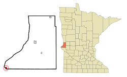
Traverse County Minnesota Incorporated and Unincorporated areas Browns Valley Highlighted.svg
Location of Browns Valley
within Traverse County, Minnesota
Coordinates: 45°35′41″N96°49′54″W / 45.59472°N 96.83167°W / 45.59472; -96.83167
CountryUnited States
State Minnesota
County Traverse
Area
[1]
  Total0.78 sq mi (2.02 km2)
  Land0.78 sq mi (2.02 km2)
  Water0.00 sq mi (0.00 km2)
Elevation
988 ft (301 m)
Population
 (2020) [2]
  Total558
  Estimate 
(2021) [3]
546
  Density714.47/sq mi (275.87/km2)
Time zone UTC-6 (CST)
  Summer (DST) UTC-5 (CDT)
ZIP code
56219
Area code 320
FIPS code 27-08200 [4]
GNIS feature ID0659752 [5]
Website brownsvalleymn.com

Browns Valley is a city in Traverse County, Minnesota, United States, adjacent to the South Dakota border. The population was 558 at the 2020 census. [2]

Contents

Browns Valley lies along the Little Minnesota River between the northern end of Big Stone Lake and the southern end of Lake Traverse, which is separated from the Little Minnesota River by a low and narrow continental divide that skirts the northern edge of town. The city, both lakes, and the river lie in the Traverse Gap, the bed of ancient, south-flowing Glacial River Warren, the outlet to Glacial Lake Agassiz which, when drained, became the valley of the north-flowing Red River of the North.

History

Browns Valley was first settled in 1867 by Joseph R. Brown, and named for him. [6] The settlement was platted in 1878. [6] A post office was established in the community in 1867 under the name Lake Traverse. [6] The post office was renamed Browns Valley in 1872. [7] Two properties in the city are listed on the National Register of Historic Places: the 1864 Fort Wadsworth Agency and Scout Headquarters Building within Sam Brown Memorial State Wayside, and the 1916 Browns Valley Carnegie Library. [8]

Geography

According to the United States Census Bureau, the city has a total area of 0.79 square miles (2.05 km2), all land. Browns Valley is rested in an old glacier path. [9]

Browns Valley Lies in the center of Traverse Gap, a valley and ancient riverbed. This valley is also home to a continental divide. The divide is the southernmost point of the Northern Divide between the watersheds of the Arctic and Atlantic oceans. The area is also home to Browns Valley Man, the oldest human remains found in Minnesota. The remains were found in Traverse Gap and carbon dated to about 9,000 years ago.

Minnesota Highways 27 and 28 are two of the main routes in the community.

Climate

The Browns Valley weather station records some of Minnesota's highest summer temperatures; on July 31, 2007, a high of 107 °F (42 °C) was registered. [10]

Climate data for Browns Valley, Minnesota (1991–2020 normals, extremes 1973–present)
MonthJanFebMarAprMayJunJulAugSepOctNovDecYear
Record high °F (°C)63
(17)
65
(18)
83
(28)
100
(38)
99
(37)
110
(43)
109
(43)
107
(42)
100
(38)
96
(36)
79
(26)
67
(19)
110
(43)
Mean daily maximum °F (°C)22.3
(−5.4)
27.1
(−2.7)
39.5
(4.2)
55.3
(12.9)
69.4
(20.8)
78.8
(26.0)
83.6
(28.7)
81.7
(27.6)
73.5
(23.1)
58.4
(14.7)
41.8
(5.4)
27.7
(−2.4)
54.9
(12.7)
Daily mean °F (°C)11.4
(−11.4)
16.1
(−8.8)
28.4
(−2.0)
42.7
(5.9)
56.3
(13.5)
66.5
(19.2)
71.1
(21.7)
68.7
(20.4)
59.8
(15.4)
46.1
(7.8)
31.1
(−0.5)
17.9
(−7.8)
43.0
(6.1)
Mean daily minimum °F (°C)0.5
(−17.5)
5.1
(−14.9)
17.3
(−8.2)
30.1
(−1.1)
43.2
(6.2)
54.3
(12.4)
58.6
(14.8)
55.6
(13.1)
46.1
(7.8)
33.8
(1.0)
20.5
(−6.4)
8.1
(−13.3)
31.1
(−0.5)
Record low °F (°C)−40
(−40)
−41
(−41)
−20
(−29)
−3
(−19)
18
(−8)
35
(2)
43
(6)
34
(1)
19
(−7)
5
(−15)
−19
(−28)
−32
(−36)
−41
(−41)
Average precipitation inches (mm)0.93
(24)
0.89
(23)
1.28
(33)
2.49
(63)
2.82
(72)
3.75
(95)
3.97
(101)
2.67
(68)
2.43
(62)
2.31
(59)
1.00
(25)
0.81
(21)
25.35
(644)
Average snowfall inches (cm)8.8
(22)
9.0
(23)
5.7
(14)
4.9
(12)
0.0
(0.0)
0.0
(0.0)
0.0
(0.0)
0.0
(0.0)
0.0
(0.0)
0.9
(2.3)
5.4
(14)
9.5
(24)
44.2
(112)
Average precipitation days (≥ 0.01 in)5.15.15.56.69.59.38.77.27.16.94.05.380.3
Average snowy days (≥ 0.1 in)4.94.53.11.60.00.00.00.00.00.52.25.121.9
Source: NOAA [11] [12]

Demographics

Historical population
CensusPop.Note
1880 64
1890 498678.1%
1900 72144.8%
1910 1,05846.7%
1920 1,0731.4%
1930 981−8.6%
1940 1,0759.6%
1950 1,1173.9%
1960 1,033−7.5%
1970 906−12.3%
1980 887−2.1%
1990 804−9.4%
2000 690−14.2%
2010 589−14.6%
2020 558−5.3%
2021 (est.)546 [3] −2.2%
U.S. Decennial Census [13]
2020 Census [2]

2010 census

As of the census of 2010, there were 589 people, 247 households, and 141 families residing in the city. The population density was 745.6 inhabitants per square mile (287.9/km2). There were 288 housing units at an average density of 364.6 per square mile (140.8/km2). The racial makeup of the city was 75.2% White, 21.4% Native American, 0.5% Asian, 0.5% from other races, and 2.4% from two or more races. Hispanic or Latino of any race were 2.7% of the population.

There were 247 households, of which 23.5% had children under the age of 18 living with them, 38.5% were married couples living together, 13.0% had a female householder with no husband present, 5.7% had a male householder with no wife present, and 42.9% were non-families. 40.5% of all households were made up of individuals, and 24.3% had someone living alone who was 65 years of age or older. The average household size was 2.23 and the average family size was 2.97.

The median age in the city was 48.3 years. 22.2% of residents were under the age of 18; 5.4% were between the ages of 18 and 24; 18.7% were from 25 to 44; 23.7% were from 45 to 64; and 30.1% were 65 years of age or older. The gender makeup of the city was 46.0% male and 54.0% female.

2000 census

As of the census of 2000, there were 690 people, 285 households, and 171 families residing in the city. The population density was 878.5 inhabitants per square mile (339.2/km2). There were 317 housing units at an average density of 403.6 per square mile (155.8/km2). The racial makeup of the city was 82.61% White, 15.80% Native American, 0.43% Asian, 0.14% Pacific Islander, 0.14% from other races, and 0.87% from two or more races. Hispanic or Latino of any race were 1.74% of the population.

There were 285 households, out of which 26.3% had children under the age of 18 living with them, 45.3% were married couples living together, 9.5% had a female householder with no husband present, and 40.0% were non-families. 36.5% of all households were made up of individuals, and 21.4% had someone living alone who was 65 years of age or older. The average household size was 2.29 and the average family size was 3.02.

In the city, the population was spread out, with 24.5% under the age of 18, 7.4% from 18 to 24, 17.8% from 25 to 44, 19.3% from 45 to 64, and 31.0% who were 65 years of age or older. The median age was 45 years. For every 100 females, there were 86.5 males. For every 100 females age 18 and over, there were 82.2 males.

The median income for a household in the city was $26,563, and the median income for a family was $30,208. Males had a median income of $25,500 versus $20,139 for females. The per capita income for the city was $15,062. About 10.3% of families and 14.4% of the population were below the poverty line, including 16.5% of those under age 18 and 11.0% of those age 65 or over.

Politics

Presidential election results
2020 Precinct Results Spreadsheet [14] 2016 Precinct Results Spreadsheet [15] 2012 Precinct Results Spreadsheet [16] 2008 Precinct Results Spreadsheet [17] 2004 Precinct Results Spreadsheet [18] 2000 Precinct Results Spreadsheet [19]
Year Republican Democratic Third parties
2020 47.6% 9150.8%971.6% 3
2016 48.8%10442.7% 918.5% 18
2012 36.3% 8158.7%1315.0% 11
2008 37.8% 10257.8%1564.4% 12
2004 39.3% 11757.0%1703.7% 11
2000 39.9% 11649.5%14410.6% 31

Notable people

Flooding

Traverse Gap from ice-covered Lake Traverse at the bottom of frame, south to Big Stone Lake (top). The Little Minnesota River is flooding the valley floor and Browns Valley (center). Browns Valley flood 07.jpg
Traverse Gap from ice-covered Lake Traverse at the bottom of frame, south to Big Stone Lake (top). The Little Minnesota River is flooding the valley floor and Browns Valley (center).

In March 2007, Browns Valley was flooded from the north and west by the Little Minnesota River. One hundred people had to be evacuated from their homes, a significant percentage of the town's population. [21] The damage was significant enough to warrant a visit from Governor Tim Pawlenty and Congressman Collin Peterson. [22]

Related Research Articles

Benton Township is a rural township in Carver County, Minnesota, United States. The population was 939 as of the 2000 census.

Camden Township is a rural township in Carver County, Minnesota, United States. The population was 955 as of the 2000 census.

Laketown Township is a township in Carver County, Minnesota, United States. The population was 2,331 as of the 2000 census.

<span class="mw-page-title-main">Nisswa, Minnesota</span> City in Minnesota, United States

Nisswa is a city in Crow Wing County, Minnesota, United States. The population was 1,971 at the 2010 census. Nisswa is part of the Brainerd Micropolitan Statistical Area, near Gull Lake.

<span class="mw-page-title-main">Apple Valley, Minnesota</span> City in Minnesota, United States

Apple Valley is a city in northwestern Dakota County in the State of Minnesota, and a suburb of the Twin Cities. The population was 56,374 at the 2020 census, making it the 17th most populous city in Minnesota.

<span class="mw-page-title-main">Farmington, Minnesota</span> City in Minnesota, United States

Farmington is a city in Dakota County, Minnesota, United States. The population was 23,632 at the 2020 census. It is a part of the Minneapolis-St. Paul metropolitan area.

<span class="mw-page-title-main">Mendota Heights, Minnesota</span> City in Minnesota, United States

Mendota Heights is a city in Dakota County, Minnesota, United States. It is a first-ring southern suburb of the Twin Cities. The population was 11,744 at the 2020 census.

<span class="mw-page-title-main">Greenfield, Minnesota</span> City in Minnesota, United States

Greenfield is a city in northwestern Hennepin County, Minnesota. It has a population of 2,903 residents, according to the 2020 United States Census, and is located 26.5 miles northwest of Minneapolis. It is part of the Twin Cities Metropolitan Statistical Area.

<span class="mw-page-title-main">Maple Plain, Minnesota</span> City in Minnesota, United States

Maple Plain is a city in Hennepin County, Minnesota, United States. The population was 1,768 at the 2010 census.

<span class="mw-page-title-main">Tonka Bay, Minnesota</span> City in Minnesota, United States

Tonka Bay is a city in Hennepin County, Minnesota, United States. It is on Lake Minnetonka between the upper and lower lakes. It gained some popularity in the 1880s and 1890s as a summer lake resort. The population was 1,475 at the 2010 census.

<span class="mw-page-title-main">Hallock, Minnesota</span> City in Minnesota, United States

Hallock is a city in and the county seat of Kittson County, Minnesota, United States. The population was 906 at the 2020 census.

<span class="mw-page-title-main">Glencoe, Minnesota</span> City in the United States

Glencoe is a city and the county seat of McLeod County, Minnesota, United States. The population was 5,744 at the 2020 census.

<span class="mw-page-title-main">Lester Prairie, Minnesota</span> City in Minnesota, United States

Lester Prairie is a city in McLeod County, Minnesota, United States, along the South Fork of the Crow River. The population was 1,894 at the 2020 census.

<span class="mw-page-title-main">Red Lake Falls, Minnesota</span> City in Minnesota, United States

Red Lake Falls is a city and the county seat of Red Lake County, Minnesota, United States. The population was 1,339 at the 2020 census. It is the county seat of Red Lake County. The city lies in the middle of Red Lake Falls Township, from which it was separated when incorporated as a village in 1881. Its status was raised to that of a city in 1898.

<span class="mw-page-title-main">Buhl, Minnesota</span> City in Minnesota, United States

Buhl is a city in Saint Louis County, Minnesota, United States. The population was 952 at the 2020 census.

<span class="mw-page-title-main">Wheaton, Minnesota</span> City in Minnesota, United States

Wheaton is a city in Traverse County, Minnesota, United States. The population was 1,460 at the 2020 census. It is the county seat.

<span class="mw-page-title-main">Montrose, Minnesota</span> City in Minnesota, United States

Montrose is a small city in Wright County, Minnesota, United States. Montrose is surrounded by farmland, prairies, and lakes. The population was 2,847 at the 2010 census.

<span class="mw-page-title-main">Howard Lake, Minnesota</span> City in Minnesota, United States

Howard Lake is a city in Wright County, Minnesota, United States. It is the host of the annual Wright county fair. The population was 1,962 at the 2010 census.

<span class="mw-page-title-main">Ortonville, Minnesota</span> City in Minnesota, United States

Ortonville is a city and the county seat of Big Stone County in the U.S. state of Minnesota at the southern tip of Big Stone Lake, along the border with South Dakota. The population was 2,021 at the 2020 census. Big Stone Lake State Park is nearby.

<span class="mw-page-title-main">Dayton, Minnesota</span> City in Minnesota, United States

Dayton is a city in Hennepin and Wright counties in the U.S. state of Minnesota. The population was 7,262 at the 2020 census. Dayton is mainly located within Hennepin County, but a part of the city extends into Wright County as well. It is the northernmost city in Hennepin County and is a suburb of the Minneapolis–St. Paul "Twin Cities" metropolitan area.

References

  1. "2020 U.S. Gazetteer Files". United States Census Bureau. Retrieved July 24, 2022.
  2. 1 2 3 "Explore Census Data". United States Census Bureau . Retrieved May 1, 2022.
  3. 1 2 "City and Town Population Totals: 2020-2021". United States Census Bureau. September 1, 2022. Retrieved September 1, 2022.
  4. "U.S. Census website". United States Census Bureau . Retrieved January 31, 2008.
  5. "US Board on Geographic Names". United States Geological Survey. October 25, 2007. Retrieved January 31, 2008.
  6. 1 2 3 Upham, Warren (1920). Minnesota Geographic Names: Their Origin and Historic Significance. Minnesota Historical Society. p. 551.
  7. "Traverse County". Jim Forte Postal History. Retrieved August 10, 2015.
  8. "National Register Information System". National Register of Historic Places . National Park Service. July 9, 2010.
  9. "US Gazetteer files 2010". United States Census Bureau. Archived from the original on July 2, 2012. Retrieved November 13, 2012.
  10. Mark Seeley (2006). "Minnesota WeatherTalk for Friday, August 4, 2006". Archived from the original on July 13, 2007. Retrieved July 21, 2007.
  11. "NowData – NOAA Online Weather Data". National Oceanic and Atmospheric Administration. Retrieved June 23, 2021.
  12. "Station: Browns Valley, MN". U.S. Climate Normals 2020: U.S. Monthly Climate Normals (1991–2020). National Oceanic and Atmospheric Administration. Retrieved June 23, 2021.
  13. United States Census Bureau. "Census of Population and Housing" . Retrieved January 23, 2014.
  14. "Minnesota Secretary Of State - 2020 Precinct Results Spreadsheet". www.sos.state.mn.us.
  15. "Minnesota Secretary Of State - 2016 Precinct Results Spreadsheet". www.sos.state.mn.us.
  16. "Minnesota Secretary Of State - 2012 Precinct Results Spreadsheet". www.sos.state.mn.us.
  17. "Minnesota Secretary Of State - 2008 Precinct Results Spreadsheet". www.sos.state.mn.us.
  18. "Minnesota Secretary Of State - 2004 Precinct Results Spreadsheet". www.sos.state.mn.us.
  19. "Minnesota Secretary Of State - 2000 Precinct Results Spreadsheet". www.sos.state.mn.us.
  20. Barrass, Malcolm. "Air Chief Marshal Sir Charles Burnett". Air of Authority - A History of RAF Organisation. Retrieved July 7, 2011.
  21. Post, Tim (March 15, 2007). "Flood recedes but tempers rise in Browns Valley". News and Features. Minnesota Public Radio. Retrieved June 2, 2007.
  22. Post, Tim (March 16, 2007). "Pawlenty and Peterson tour Browns Valley". News and Features. Minnesota Public Radio. Retrieved June 2, 2007.

45°35′43″N96°50′00″W / 45.59528°N 96.83333°W / 45.59528; -96.83333