Fort Snelling, originally known as Fort Saint Anthony, is a United States military fortification located at the confluence of the Minnesota and Mississippi rivers in Hennepin County, Minnesota. The Mississippi National River and Recreation Area, a National Park Service unit, includes historic Fort Snelling.
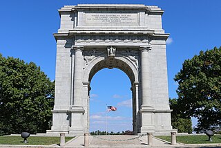
Valley Forge National Historical Park is the site of the third winter encampment of the Continental Army during the American Revolutionary War, taking place from December 19, 1777 to June 19, 1778. The National Historical Park preserves the site and interprets the history of the Valley Forge encampment. Originally Valley Forge State Park, it became a national historical park in 1976. The Park contains historical buildings, recreated encampment structures, memorials, museums, and recreation facilities.

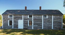
Fort Ridgely was a United States Army outpost (1853–1867) near the Dakota reservation in southwestern Minnesota. Built between 1853–1854, it was named for three officers named Ridgely who were killed in the Mexican–American War. The fort played an important role in the Dakota War of 1862. The Battle of Fort Ridgely was fought there in two engagements over August 20–22, 1862 between Army volunteers and refugees from the Minnesota River valley, and Dakota forces.

This is a list of sites in Minnesota which are included in the National Register of Historic Places. There are more than 1,600 properties and historic districts listed on the NRHP; each of Minnesota's 87 counties has at least 2 listings. Twenty-two sites are also National Historic Landmarks.
Camp Release State Monument is located on the edge of Montevideo, Minnesota, United States, just off Highway 212. The Camp Release Monument stands as a reminder of Minnesota's early state history. The Minnesota River Valley and Montevideo were important sites in the Dakota War of 1862. In the fall of 1862, the Dakota tribes surrendered to Colonel Henry Hastings Sibley on a bluff overlooking the valley and the present-day site of Montevideo. The monument was the first property added to the state park system and was listed on the National Register of Historic Places in 1973.

Lac qui Parle State Park is a state park of Minnesota, United States, near Watson. Lac qui Parle is a French translation of the native Dakota name, meaning "lake which speaks".

Minnesota Valley State Recreation Area is a 5,490-acre (2,222 ha) unit of the Minnesota state park system. The park is not continuous but is composed of waysides, four of which are strung along the Minnesota River between Shakopee and Belle Plaine. The various waysides are interspersed with units of the Minnesota Valley National Wildlife Refuge. Although the state recreation area is managed by the Minnesota Department of Natural Resources and the national wildlife refuge by the United States Fish and Wildlife Service, both agencies share a consistent signage to simplify visitation.

The St. Croix Boom Site is a historic and scenic wayside on the St. Croix River in Stillwater Township, Minnesota, United States. It commemorates the location of a critical log boom where, from 1856 to 1914, timber from upriver was sorted and stored before being dispatched to sawmills downstream. The site was developed as a roadside park along Minnesota State Highway 95 in the 1930s. In 1966 it was designated a National Historic Landmark for its national significance in the theme of industry. It was nominated for being the earliest, most important, and longest serving of the log storage and handling operations that supported Minnesota's major logging industry. Virtually no traces remain of the site's original buildings and structures.

The Joseph R. Brown State Wayside Rest is a National Scenic Byway Wayside Rest area. It is located on Renville County Highway 15, south of Sacred Heart, Minnesota, United States.

The Marine Mill, established in 1839, was the first commercial sawmill in what became the U.S. state of Minnesota. Now in ruins, it is currently a historic site managed by the city of Marine on St. Croix in partnership with the Minnesota Historical Society. It was listed on the National Register of Historic Places as the Marine Mill Site in 1970 for having state-level significance in the themes of exploration/settlement, industry, and transportation. It was nominated for being the birthplace of the region's seminal industry—lumbering—and a major landing on its crucial transportation route, the St. Croix River. The site is also a contributing property to the Marine on St. Croix Historic District.

This is a list of the National Register of Historic Places listings in Morrison County, Minnesota. It is intended to be a complete list of the properties and districts on the National Register of Historic Places in Morrison County, Minnesota, United States. The locations of National Register properties and districts for which the latitude and longitude coordinates are included below, may be seen in an online map.

This is a list of the National Register of Historic Places listings in Nicollet County, Minnesota. It is intended to be a complete list of the properties and districts on the National Register of Historic Places in Nicollet County, Minnesota, United States. The locations of National Register properties and districts for which the latitude and longitude coordinates are included below, may be seen in an online map.

This is a list of the National Register of Historic Places listings in Fillmore County, Minnesota. It is intended to be a complete list of the properties and districts on the National Register of Historic Places in Fillmore County, Minnesota, United States. The locations of National Register properties and districts for which the latitude and longitude coordinates are included below, may be seen in an online map.

Birch Coulee Battlefield in Renville County, Minnesota, United States, was the site of the Battle of Birch Coulee, the costliest military engagement for U.S. forces during the Dakota War of 1862. It is now a historic site with self-guided trails and markers interpreting the battle from both sides. Birch Coulee was nominated to the National Register of Historic Places for having state-level significance in military history, and was listed in 1973.

The Banfill Tavern, also known as the Locke House, is a historic building in Fridley, Minnesota, United States. It was built in 1847 on the east bank of the Mississippi River and has served variously as an inn, a logging camp office, a private home, a dairy farm, a post office, and a summer home. It is now owned by Anoka County and houses the non-profit Banfill-Locke Center for the Arts. The building stands within Manomin County Park, and the art center is a partner site of the Mississippi National River and Recreation Area.

The Redoubt St. Archangel Michael Site, also known as the Old Sitka Site and now in Old Sitka State Historical Park, is a National Historic Landmark near Sitka, Alaska. Now of archaeological interest, the site, about 7 miles (11 km) north of Sitka at the end of Halibut Point Road, was the site of the early Russian-American Company settlement known as Redoubt St. Archangel Michael. It was the first non-Native settlement on Baranof Island. It was declared a National Historic Landmark in 1962, and was made a state park in 1966.

The N.K. Boswell Ranch is one of the oldest ranches on the edge of the Laramie Plains along the Big Laramie River in Albany County, Wyoming, USA. The ranch was established in the early 1870s, possibly by a man named C.T. Waldron. The ranch is significant for its association with Nathaniel K. Boswell, who was Albany County Sheriff at a time when the county extended from Colorado to Montana.