Sakatah Lake State Park

Last updated
Sakatah Lake State Park
Minnesota State Park
SakatahLakeStatePark.jpg
Sakatah Lake State Park as seen from the east shore of Sakatah Lake
Country United States
State Minnesota
Counties Le Sueur, Rice
Location Waterville
 - elevation1,076 ft (328 m) [1]
 - coordinates 44°13′15″N93°32′8″W / 44.22083°N 93.53556°W / 44.22083; -93.53556 Coordinates: 44°13′15″N93°32′8″W / 44.22083°N 93.53556°W / 44.22083; -93.53556
Area842 acres (341 ha)
Founded1963
Management Minnesota Department of Natural Resources
USA Minnesota location map.svg
Red pog.svg
Location of Sakatah Lake State Park in Minnesota
Usa edcp relief location map.png
Red pog.svg
Sakatah Lake State Park (the US)

Sakatah Lake State Park is an 842-acre (341 ha) state park of Minnesota, USA, on a natural widening of the Cannon River near the town of Waterville. The Dakota native to the area called it "Sakatah" which means "singing hills". To honor this native heritage, some of the trails in the park have been given Dakota names. The Sakatah Singing Hills State Trail, which connects Faribault and Mankato, runs through this park.

State park protected area managed at the federated state level

State parks are parks or other protected areas managed at the sub-national level within those nations which use "state" as a political subdivision. State parks are typically established by a state to preserve a location on account of its natural beauty, historic interest, or recreational potential. There are state parks under the administration of the government of each U.S. state, some of the Mexican states, and in Brazil. The term is also used in the Australian state of Victoria. The equivalent term used in Canada, Argentina, South Africa and Belgium, is provincial park. Similar systems of local government maintained parks exist in other countries, but the terminology varies.

Minnesota State of the United States of America

Minnesota is a state in the Upper Midwest and northern regions of the United States. Minnesota was admitted as the 32nd U.S. state on May 11, 1858, created from the eastern half of the Minnesota Territory. The state has a large number of lakes, and is known by the slogan the "Land of 10,000 Lakes". Its official motto is L'Étoile du Nord.

Cannon River (Minnesota) river in Minnesota, United States of America


The Cannon River a tributary of the Mississippi River flows 112 miles (180 km) from Lake Tetonka near Waterville to Red Wing in the U.S. state of Minnesota, where it joins the Mississippi River. It drains a watershed approximately 1460 square miles (3,780 km²) in size. The river flows through the counties of Le Sueur, Rice, Dakota, and Goodhue.

Contents

Natural history

The park sits on a thick moraine deposited during the Wisconsin glaciation, resulting in a rolling and uneven topography. Blocks of ice left behind as the glaciers melted formed the basin in which Sakatah Lake now lies.

Moraine Glacially formed accumulation of unconsolidated debris

A moraine is any glacially formed accumulation of unconsolidated glacial debris that occurs in both currently and formerly glaciated regions on Earth, through geomorphological processes. Moraines are formed from debris previously carried along by a glacier and normally consisting of somewhat rounded particles ranging in size from large boulders to minute glacial flour. Lateral moraines are formed at the side of the ice flow and terminal moraines at the foot, marking the maximum advance of the glacier. Other types of moraine include ground moraines, till-covered areas with irregular topography, and medial moraines which are formed where two glaciers meet.

Wisconsin glaciation

The Wisconsin Glacial Episode, also called the Wisconsinan glaciation, was the most recent glacial period of the North American ice sheet complex. This advance included the Cordilleran Ice Sheet, which nucleated in the northern North American Cordillera; the Innuitian ice sheet, which extended across the Canadian Arctic Archipelago; the Greenland ice sheet; and the massive Laurentide ice sheet, which covered the high latitudes of central and eastern North America. This advance was synchronous with global glaciation during the last glacial period, including the North American alpine glacier advance, known as the Pinedale glaciation. The Wisconsin glaciation extended from approximately 75,000 to 11,000 years ago, between the Sangamon interglacial and the current interglacial, the Holocene. The maximum ice extent occurred approximately 25,000–21,000 years ago during the last glacial maximum, also known as the Late Wisconsin in North America.

The park preserves a mixed transitional habitat where the Big Woods (maple, basswood, elm) of central Minnesota blend into the oak barrens of the southern part of the state. During drier eras patches of prairie arose, although they are now succeeding back to hardwood forests. The landscape is further diversified by wetlands and agricultural fields.

Big Woods

Big Woods refers to a type of temperate hardwood forest ecoregion found in western Wisconsin and south-central Minnesota. "Big Woods" is a direct translation of the name given to the region by French explorers: Grand Bois.

Maple genus of plants

Acer is a genus of trees and shrubs commonly known as maple. The genus is placed in the family Sapindaceae. There are approximately 128 species, most of which are native to Asia, with a number also appearing in Europe, northern Africa, and North America. Only one species, Acer laurinum, extends to the Southern Hemisphere. The type species of the genus is the sycamore maple, Acer pseudoplatanus, the most common maple species in Europe. The maples have easily recognizable palmate leaves and distinctive winged fruits. The closest relatives of the maples are the horse chestnuts.

Elm genus of plants

Elms are deciduous and semi-deciduous trees comprising the flowering plant genus Ulmus in the plant family Ulmaceae. The genus first appeared in the Miocene geological period about 20 million years ago, originating in what is now central Asia. These trees flourished and spread over most of the Northern Hemisphere, inhabiting the temperate and tropical-montane regions of North America and Eurasia, presently ranging southward across the Equator into Indonesia.

Wildlife

This park is home to deer, rabbits, squirrels, raccoon, minks, and coyotes. These mammals are commonly seen by visitors. Bird watchers get an opportunity to view songbirds, woodpeckers, various hawks, and various owls in this park.

Deer family of mammals

Deer are the hoofed ruminant mammals forming the family Cervidae. The two main groups are the Cervinae, including the muntjac, the elk (wapiti), the fallow deer, and the chital; and the Capreolinae, including the reindeer (caribou), the roe deer, and the moose. Female reindeer, and male deer of all species except the Chinese water deer, grow and shed new antlers each year. In this they differ from permanently horned antelope, which are part of a different family (Bovidae) within the same order of even-toed ungulates (Artiodactyla).

Rabbit Mammals of the family Leporidae

Rabbits are small mammals in the family Leporidae of the order Lagomorpha. Oryctolagus cuniculus includes the European rabbit species and its descendants, the world's 305 breeds of domestic rabbit. Sylvilagus includes 13 wild rabbit species, among them the 7 types of cottontail. The European rabbit, which has been introduced on every continent except Antarctica, is familiar throughout the world as a wild prey animal and as a domesticated form of livestock and pet. With its widespread effect on ecologies and cultures, the rabbit is, in many areas of the world, a part of daily life—as food, clothing, a companion, and as a source of artistic inspiration.

Squirrel family of mammals

Squirrels are members of the family Sciuridae, a family that includes small or medium-size rodents. The squirrel family includes tree squirrels, ground squirrels, chipmunks, marmots, flying squirrels, and prairie dogs amongst other rodents. Squirrels are indigenous to the Americas, Eurasia, and Africa, and were introduced by humans to Australia. The earliest known squirrels date from the Eocene period and are most closely related to the mountain beaver and to the dormouse among other living rodent families.

Cultural history

The Wahpekute band of Dakota Sioux traditionally inhabited this area, using the Cannon River as an important transportation route. Some of their burial mounds remain in the park. European settlement came in the late 1800s, and a rail line was laid between Faribault and Waterville in 1882, and extended to Mankato by 1886. By chance the forest on the south shore of Sakatah Lake was never logged, and a 1962 inquiry into making it a state park received much local support. The site was included in a bill that passed the next year which authorized fourteen state parks. Development occurred over the next few years and Sakatah Lake State Park officially opened to the public in 1967. Although there was a rail line running through the park, it was only occasionally used, and in 1976 the owners abandoned it entirely and willingly sold it to the state, which converted it into the Sakatah Singing Hills State Trail.

Sioux Native American and First Nations people in North America

The Sioux, also known as Očhéthi Šakówiŋ, are groups of Native American tribes and First Nations peoples in North America. The term can refer to any ethnic group within the Great Sioux Nation or to any of the nation's many language dialects. The modern Sioux consist of two major divisions based on language divisions: the Dakota and Lakota.

Faribault, Minnesota City in Minnesota, United States

Faribault is a city in Rice County, Minnesota, United States. It is the county seat. The population was 23,352 at the 2010 census. Faribault is approximately 50 miles (80 km) south of Minneapolis and St. Paul.

Waterville, Minnesota City in Minnesota, United States

Waterville is a city in Le Sueur County, Minnesota, United States. The population was 1,868 at the 2010 census. It is close to Sakatah Lake State Park on the Cannon River.

Recreation

Sakatah Singing Hills State Trail

Sakatah Singing Hills State Trail is a 41-mile-long (66 km) paved multi-use rail trail connecting Faribault and Mankato, Minnesota, US.

Related Research Articles

McArthur–Burney Falls Memorial State Park

McArthur–Burney Falls Memorial State Park is the second oldest state park in the California State Parks system, located approximately 6 miles (9.7 km) north of Burney, California. The park offers camping, fishing, watersports, hiking and horseback riding facilities. The park is mainly known for the waterfall, Burney Falls, at the entrance of the park. Wildlife in the park includes bass, trout, Steller's jay, squirrels, woodpeckers, deer, and on rare occasion, black bear.

Afton State Park

Afton State Park is a state park of Minnesota, USA, on the St. Croix River in Washington County. Its hiking trails offer views of the river, rolling glacial moraine, and bluffland it preserves. It is a popular place for birdwatching, picnics, camping, and other typical outdoor recreational activities. To deter overuse of a state park only 20 miles (32 km) from downtown St. Paul, there is no vehicle access to the camping area or swimming beach.

Tettegouche State Park

Tettegouche State Park, in the United States, is a Minnesota state park on the north shore of Lake Superior 58 miles (93 km) northeast of Duluth in Lake County on scenic Minnesota Highway 61. The park's name stems from the Tettegouche Club, an association of local businessmen which purchased the park in 1910 from the Alger-Smith Lumber Company. The club's members protected the area until its sale in 1971 to the deLaittres family. In 1979, the state of Minnesota acquired 3,400 acres (1,400 ha) from the Nature Conservancy, including Tettegouche Camp. The land was added to Baptism River State Park, which was renamed Tettegouche State Park.

William OBrien State Park

William O'Brien State Park is a 1,520-acre (6.2 km2) state park of Minnesota, USA, along the St. Croix River. Its hiking trails traverse rolling glacial moraine, riparian zones, restored oak savanna, wooded areas and bogs. It is a popular place for birdwatching, picnics, camping, cross-country skiing, canoeing, fishing, and other typical outdoor recreational activities.

Fort Snelling State Park state park in Minnesota, United States

Fort Snelling State Park is a state park of Minnesota, USA, at the confluence of the Mississippi and Minnesota rivers. Its most notable feature is the historic Fort Snelling, which dates from 1820. The fort itself is operated by the Minnesota Historical Society and requires a separate entrance fee. The bulk of the state park preserves the bottomland forest, rivers, and backwater lakes below the river bluffs. The park was opened in 1962. Both the State Park and Historic Fort are part of the Mississippi National River and Recreation Area, a National Park Service site.

Frontenac State Park

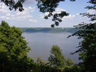
Frontenac State Park is a state park of Minnesota, United States, on the Mississippi River 10 miles (16 km) southeast of Red Wing. The park is notable both for its history and for its birdwatching opportunities. The centerpiece of the park is a 430-foot-high (130 m), 3-mile-long (4.8 km) steep limestone bluff overlooking Lake Pepin, a natural widening of the Mississippi. The bluff is variously called Garrard's Bluff or Point No-Point, the latter name coming from riverboat captains because of the optical illusion that it protruded into the Mississippi River. There is a natural limestone arch on the blufftop called In-Yan-Teopa, a Dakota name meaning "Rock With Opening". Park lands entirely surround the town of Frontenac, once a high-class resort at the end of the 19th century.

Minneopa State Park

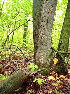
Minneopa State Park is a state park in the U.S. state of Minnesota. It was established in 1905 to preserve Minneopa Falls, a large waterfall for southern Minnesota, and was expanded in the 1960s to include the lower reaches of Minneopa Creek and a large tract of prairie. Minneopa is Minnesota's third oldest state park, after Itasca and Interstate. Two park resources are listed on the National Register of Historic Places: the 1862 Seppman Mill and a district of seven Rustic Style structures built by the Works Progress Administration in the late 1930s. The park is located almost entirely on the south side of the Minnesota River, 3 miles (4.8 km) west of Mankato. In 2015 the state reintroduced American bison to the park in a 330-acre (130 ha) fenced enclosure, through which visitors can drive in their vehicles.

Rice Lake State Park state park in Minnesota, United States

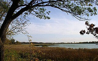
Rice Lake State Park is a state park of Minnesota, United States, just east of Owatonna. Park lands entirely surround Rice Lake, an important stopping point for migrating waterfowl. The lake covers 750 acres (300 ha) with an average depth of 3 feet (1 m).

Cannon Valley Trail

The Cannon Valley Trail is a paved rail trail that follows the Cannon River in southeast Minnesota.

Three Rivers Park District

Three Rivers Park District is a special park district serving the suburban areas of the Twin Cities including suburban Hennepin, Carver, Dakota, Scott and Ramsey counties. Three Rivers's mission is "To promote environmental stewardship through recreation and education in a natural resources-based park system." Three Rivers operates twenty parks and ten regional trails, with at least two more regional trails planned. Nearly seven million people visit Three Rivers facilities each year.

Lebanon Hills Regional Park

Lebanon Hills Regional Park is located in the Minnesota cities of Eagan and Apple Valley. The 1,869-acre (7.56 km2) park, the largest in Dakota County, contains forests, grasslands, marshes, and wetlands. Winter activities include skiing, snowshoeing, ice skating, ice fishing, hiking, and winter mountain biking. Summer activities include mountain biking, canoeing, kayaking, swimming, camping, horseback riding, and hiking.

Lake Bemidji State Park

Lake Bemidji State Park is a state park of Minnesota, United States, on the north shore of 6,765-acre (27.38 km2) Lake Bemidji. The northern half of the park preserves a spruce-tamarack bog. A district of National Park Service rustic structures built by the Civilian Conservation Corps and National Youth Administration in the 1930s is on the National Register of Historic Places. The park is located 5 miles (8.0 km) north of the city of Bemidji.

Lake Maria State Park

Lake Maria State Park is a state park of Minnesota, United States, created to provide a wilderness area within an easy drive of Minneapolis–Saint Paul. The park's amenities are designed primarily for hikers, backpackers, and horseback riders and consequently use remains light compared to other state parks around the metro area. It preserves a remnant of Big Woods atop a hilly, glacially-formed landscape dotted with lakes and wetlands. The park was established in 1963 west of Monticello, Minnesota.

Willow River State Park

Willow River State Park is a 2,891-acre (1,170 ha) Wisconsin state park located five miles north of Hudson. The centerpiece of the park is Willow Falls, a powerful cascade in a 200-foot (61 m) deep gorge. Another popular feature is Little Falls Lake, a shallow reservoir on the Willow River. Because of its proximity to Minneapolis-St. Paul it is one of the most visited state parks in Wisconsin. Trilobite fossils found in the lower layers of the gorge indicate the rock is around 600 million years old.

Pinckney State Recreation Area

Pinckney State Recreation Area is a Michigan state recreation area in Dexter, Sylvan and Lyndon Townships, Washtenaw County and Putnam and Unadilla Townships, Livingston County in the U.S. state of Michigan. The park is 11,000 acres (4,500 ha) and sits at an elevation of 922 feet (281 m). The park is connected to the nearby Waterloo State Recreation Area by the 35-mile (56 km) Waterloo–Pinckney Trail. Pinckney State Recreation Area is open for year-round recreation including hiking, fishing, swimming, hunting and a variety of winter sports.

Greenbrier State Park

Greenbrier State Park is a public recreation area located on South Mountain near Boonsboro in Washington County, Maryland, USA. The state park has camping, hiking trails, and a 42-acre (17 ha) man-made lake. It is managed by the Maryland Department of Natural Resources.

Mill Towns Trail

The Mill Towns State Trail is a multi-use trail in development along the Cannon River. Currently a 3-mile-long (4.8 km) rail trail linking Northfield and Dundas, the trail is planned to extend southward to Faribault and eastward to Cannon Falls.

References

  1. "Sakatah State Park". Geographic Names Information System . United States Geological Survey. 1980-01-11. Retrieved 2011-02-25.