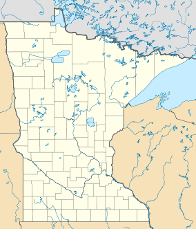
Breitung Township is a township in Saint Louis County, Minnesota, United States. The population was 605 at the 2010 census.

The Mesabi Iron Range is an elongate trend containing large deposits of iron ore, and the largest of four major iron ranges in the region collectively known as the Iron Range of Minnesota. Discovered in 1866, it is the chief iron ore mining district in the United States. The district is located in northeast Minnesota, largely in Itasca and Saint Louis counties. It was extensively worked in the earlier part of the 20th century. Extraction operations declined throughout the mid-1970s but rebounded in 2005. China's growing demand for iron, along with the falling value of the U.S. dollar versus other world currencies, have made taconite production profitable again, and some mines that had closed have been reopened, while current mines have been expanded.
Iron Range refers collectively or individually to a number of elongated iron-ore mining districts around Lake Superior in the United States and Canada. Despite the word "range," the iron ranges are not mountain chains, but outcrops of Precambrian sedimentary formations containing high percentages of iron. These cherty iron ore deposits are Precambrian in age for the Vermilion Range, while middle Precambrian in age for the Mesabi and Cuyuna ranges, all in Minnesota. The Gogebic Range in Wisconsin and the Marquette Iron Range and Menominee Range in Michigan have similar characteristics and are of similar age. Natural ores and concentrates were produced from 1848 until the mid 1950s, when taconites and jaspers were concentrated and pelletized, and started to become the major source of iron production.

Lake Vermilion is a freshwater lake in northeastern Minnesota, United States. The Ojibwe originally called the lake Nee-Man-Nee, which means “the evening sun tinting the water a reddish color”. French fur traders translated this to the Latin word Vermilion, which is a red pigment. Lake Vermilion is located between the towns of Tower on the east and Cook on the west, in the heart of Minnesota's Arrowhead Region at Vermilion Iron Range. The area was mined from the late 19th century until the 1960s, and the Soudan Mine operated just south of the lake.
The Vermilion Range exists between Tower and Ely, Minnesota, and contains significant deposits of iron ore. Together with the Mesabi and Cuyuna Ranges, these three constitute the Iron Ranges of northern Minnesota; they were deposited in the Animikie Group. While the Mesabi Range had iron ore close enough to the surface to enable pit mining, mines had to be dug deep underground to reach the ore of the Vermilion and Cuyuna ranges. The Soudan mine was nearly 1/2 mile underground and required blasting of Precambrian sedimentary bedrock.
The Cuyuna Range is an iron range to the southwest of the Mesabi Range, largely within Crow Wing County, Minnesota. It lies along a 68-mile-long (109 km) line between Brainerd, Minnesota, and Aitkin, Minnesota. The width ranges from 1 to 10 miles.

The Soudan Underground Mine State Park is a Minnesota state park at the site of the Soudan Underground Mine, on the south shore of Lake Vermilion, in the Vermilion Range (Minnesota). The mine is known as Minnesota's oldest, deepest, and richest iron mine, and now hosts the Soudan Underground Laboratory. As the Soudan Iron Mine, it has been designated a U.S. National Historic Landmark.

The Minnesota Department of Natural Resources is the agency of the U.S. state of Minnesota charged with conserving and managing the state's natural resources. The agency maintains areas such as state parks, state forests, recreational trails, and recreation areas as well as managing minerals, wildlife, and forestry throughout the state. The agency is divided into six divisions - Ecological & Water Resources, Enforcement, Fish & Wildlife, Forestry, Lands & Minerals, and Parks & Trails.

Muskallonge Lake State Park is a public recreation area on Lake Superior sixteen miles (26 km) east of Grand Marais in Luce County, Michigan. The state park covers 217 acres (88 ha) between the shores of Lake Superior and Muskallonge Lake where Native American's once had an encampment and where a station of the United States Life-Saving Service once stood. The park offers swimming and fishing and includes a 159-site campground, boat launch, picnic area, playground, and trails for hiking and snow-mobiling.
Minnesota State Highway 169 is a highway in northeast Minnesota, which runs from its interchange with U.S. Highway 53 in Wuori Township and continues northeast to its northern terminus at the intersection of Lake County Road 18 and Power Dam Road in Fall Lake Township. State Highway 169 becomes Lake County Road 18 at this point.

Kickapoo State Recreation Area is an Illinois state park on 2,842 acres (1,150 ha) in Vermilion County, Illinois, United States. Located just outside Danville, Illinois, this park is easily accessible through route I-74. It is 28 miles (45 km) away from the University of Illinois at Urbana-Champaign and 95 miles (153 km) from Indianapolis. According to the Illinois Department of Natural Resources, the name Kickapoo originated from the Kickapoo village that once existed near the junction of the Salt Fork and Middle Fork branches of the Vermilion River. After Europeans settled in the area and displaced the Native Americans, the Europeans began to dig wells to harvest salt from salt springs, called salines. In the early 20th century the land was then strip-mined for coal. Kickapoo State Park was the first park in the United States to be located on strip-mined land. The state of Illinois purchased the Kickapoo State Park Area in 1939 with donation money from Danville residents and the land has since recovered from the extraction of these resources.
Soudan is an unincorporated community and census-designated place (CDP) in Breitung Township, Saint Louis County, Minnesota, United States. As of the 2010 census, its population was 446.
The Taconite State Trail extends 165 miles from Grand Rapids, Minnesota to Ely, Minnesota and intersects the Arrowhead State Trail west of Lake Vermilion. On the Grand Rapids end, the trail is paved for the first 6 miles for in-line skating and biking. The rest of the trail is natural surface used primarily in the winter months for snowmobiling. In the summer, several areas contain standing water, but some areas are suitable for horseback riding, hiking, and mountain biking
The Bear Island State Forest is a state forest in Minnesota bordered by the towns of Ely, Babbitt, and Tower in Lake and Saint Louis counties. It is adjacent to the Burntside State Forest and the federally managed Superior National Forest and Boundary Waters Canoe Area Wilderness. It is managed primarily by the Minnesota Department of Natural Resources and the counties.
The Kabetogama State Forest is a state forest located in Koochiching and Saint Louis counties, Minnesota. The forest borders the Superior National Forest and the Boundary Waters Canoe Area Wilderness to the east, the Sturgeon River State Forest to the south, the Nett Lake Indian Reservation to the west, and Voyageurs National Park to the north. The forest is managed by the Minnesota Department of Natural Resources.
The Heartland State Trail is a multi-use recreational rail trail in north-central Minnesota, USA. It runs 49 miles (79 km) between Park Rapids and Cass Lake, intersecting with the Paul Bunyan State Trail around Walker. The entire route is paved, with a parallel grass trackway along the southern half for horseback riding and mountain biking. The northern half of the trail has some parallel trackway for snowmobiles. A 4-mile (6.4 km) segment north of Walker traverses very hilly terrain to appeal to snowmobilers; other users can follow a marked alternate route on paved road shoulders.

Greenleaf Lake State Recreation Area is a state park unit of Minnesota, USA, currently in development. It includes undeveloped shoreline on both Greenleaf and Sioux Lakes, halfway between the cities of Hutchinson and Litchfield in Meeker County. Portions of the state recreation area (SRA) are open to the public for day-use recreation, but there are no facilities yet on site. The park boundaries were set by the Minnesota Legislature and the state is still acquiring land from willing sellers; two-thirds of the property remain privately owned.

The Stuntz Bay Boathouse Historic District comprises a row of 143 boathouses on Lake Vermilion in Breitung Township, Minnesota, United States. They were mostly built in the first half of the 20th century by employees of the adjacent Soudan Iron Mine. The mining company provided the lots to employees as a reward for their years of service, and the miners did their own construction. Most of the boathouses were built with tamarack logs and scrap corrugated metal from the mine property. Boating and fishing were major pastimes for the mine employees and their families in their leisure hours, and the mining company promoted access to outdoor recreation as a perk of employment. The Stuntz Bay Boathouses were listed as a historic district on the National Register of Historic Places in 2007 for their local significance in the themes of architecture, entertainment/recreation, industry, and social history. They were nominated for illustrating the personal lives of the miners and vernacular metal architecture.

The Pioneer Mine was an underground iron mine in Ely, Minnesota, United States, in operation from 1889 to 1967. It is one of only two such mines on the Vermilion Range whose above-ground structures are still standing, the other being the Soudan Mine. The Pioneer Mine Buildings and "A" Headframe were listed on the National Register of Historic Places as a historic district in 1978 for their state-level significance in the themes of engineering and industry. They were nominated for being some of the last vestiges of a once-common mining technique on the Vermilion Range.