Fayette Historic State Park is the state park of the historic town of Fayette in the U.S. state of Michigan. It is located on the Big Bay de Noc of Lake Michigan, between Snail Shell Harbor and Sand Bay, on the southern side of the Upper Peninsula, about 17 miles south of US 2. Fayette was the site of an industrial community that manufactured charcoal pig iron between 1867 and 1891. The town has been reconstructed into a living museum, showing what life was like in this town in the late 19th century. It was listed on the National Register of Historic Places in 1970.

Carley State Park is a state park of Minnesota, United States, about 15 miles (24 km) northeast of Rochester and about 2 miles (3.2 km) south of Plainview in Wabasha County. It is used for picnics, camping, hiking, and other outdoor recreation. It is known for the bluebell flowers that bloom there every spring.

Great River Bluffs State Park is a state park of Minnesota, United States, on the Mississippi River southeast of Winona. Originally known as O. L. Kipp State Park, it was renamed in the late 1990s to describe better its resources. The park preserves steep-sided bluffs rising 500 feet (150 m) above the river and the narrow valleys between them, which support rare and fragile plant communities. Two of the bluffs have received further protection under the Minnesota Scientific and Natural Areas program, which are known as King's and Queen's Bluff Scientific and Natural Area.

Afton State Park is a state park of Minnesota, USA, on the St. Croix River in Washington County. Its hiking trails offer views of the river, rolling glacial moraine, and bluffland it preserves. It is a popular place for birdwatching, picnics, camping, and other typical outdoor recreational activities. To deter overuse of a state park only 20 miles (32 km) from downtown St. Paul, there is no vehicle access to the camping area or swimming beach.
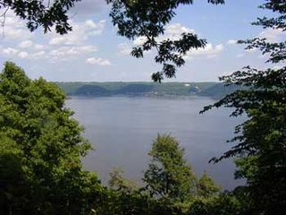
Frontenac State Park is a state park of Minnesota, United States, on the Mississippi River 10 miles (16 km) southeast of Red Wing. The park is notable both for its history and for its birdwatching opportunities. The centerpiece of the park is a 430-foot-high (130 m), 3-mile-long (4.8 km) steep limestone bluff overlooking Lake Pepin, a natural widening of the Mississippi. The bluff is variously called Garrard's Bluff or Point No-Point, the latter name coming from riverboat captains because of the optical illusion that it protruded into the Mississippi River. There is a natural limestone arch on the blufftop called In-Yan-Teopa, a Dakota name meaning "Rock With Opening". Park lands entirely surround the town of Frontenac, once a high-class resort at the end of the 19th century.

Buffalo River State Park is a state park of Minnesota, United States, conserving a prairie bisected by the wooded banks of the Buffalo River. Together with the adjacent Bluestem Prairie Scientific and Natural Area owned by The Nature Conservancy, it protects one of the largest and highest-quality prairie remnants in Minnesota. With the closest swimming lake to the Fargo–Moorhead metropolitan area, however, it is most popular for swimming and picnicking. The 1,068-acre (432 ha) park is located just off U.S. Route 10 in Clay County, 4.5 miles (7.2 km) east of Glyndon and 14 miles (23 km) east of Moorhead.

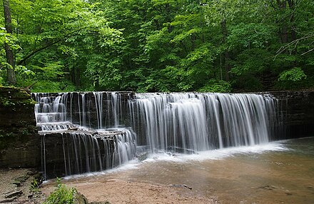
Minneopa State Park is a state park in the U.S. state of Minnesota. It was established in 1905 to preserve Minneopa Falls, a large waterfall for southern Minnesota, and was expanded in the 1960s to include the lower reaches of Minneopa Creek and a large tract of prairie. Minneopa is Minnesota's third oldest state park, after Itasca and Interstate. Two park resources are listed on the National Register of Historic Places: the 1862 Seppman Mill and a district of seven Rustic Style structures built by the Works Progress Administration in the late 1930s. The park is located almost entirely on the south side of the Minnesota River, 3 miles (4.8 km) west of Mankato. In 2015 the state reintroduced American bison to the park in a 330-acre (130 ha) fenced enclosure, through which visitors can drive in their vehicles.

Beaver Creek Valley State Park is a state park of Minnesota, United States, featuring a steep, narrow valley carved by East Beaver Creek. This spring-fed stream is a fishing destination for its native brook trout, and introduced brown trout. The park rests on a heavily forested valley, up to 250 feet (76 m) deep in places, amidst the farmland of southeastern Minnesota. Located near the town of Caledonia, the park was developed in the 1930s by the Works Progress Administration. The parkland exhibits the highly stream-carved terrain characteristic of the Driftless Area.
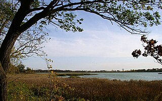
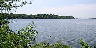
Rice Lake State Park is a state park of Minnesota, United States, just east of Owatonna. Park lands entirely surround Rice Lake, an important stopping point for migrating waterfowl. The lake covers 750 acres (300 ha) with an average depth of 3 feet (1 m).

St. Croix State Park is a state park in Pine County, Minnesota, USA. The park follows the shore of the St. Croix River for 21 miles (34 km) and contains the last 7 miles (11 km) of the Kettle River. At 33,895 acres (13,717 ha) it is the largest Minnesota state park. It was developed as a Recreational Demonstration Area in the 1930s, and is one of the finest surviving properties of this type in the nation. 164 structures built by the Civilian Conservation Corps and the Works Progress Administration survive, the largest collection of New Deal projects in Minnesota. As a historic district they were listed on the National Register of Historic Places and proclaimed a National Historic Landmark in 1997.
Sakatah Lake State Park is an 842-acre (341 ha) state park of Minnesota, USA, on a natural widening of the Cannon River near the town of Waterville. The Dakota native to the area called it "Sakatah" which means "singing hills". To honor this native heritage, some of the trails in the park have been given Dakota names. The Sakatah Singing Hills State Trail, which connects Faribault and Mankato, runs through this park.

Lake Shetek State Park is a state park of Minnesota, United States, on Lake Shetek, which is the largest lake in southwestern Minnesota and the headwaters of the Des Moines River. It is most popular for water recreation and camping. However the park also contains historical resources related to the Dakota War of 1862, including an original log cabin and a monument to 15 white settlers killed there and at nearby Slaughter Slough on August 20, 1862.

Lake Maria State Park is a state park of Minnesota, United States, created to provide a wilderness area within an easy drive of Minneapolis–Saint Paul. The park's amenities are designed primarily for hikers, backpackers, and horseback riders and consequently use remains light compared to other state parks around the metro area. It preserves a remnant of Big Woods atop a hilly, glacially-formed landscape dotted with lakes and wetlands. The park was established in 1963 west of the city of Monticello.

Willow River State Park is a 2,891-acre (1,170 ha) Wisconsin state park located five miles (8 km) north of Hudson. The centerpiece of the park is Willow Falls, a powerful cascade in a 200-foot (61 m) deep gorge. Another popular feature is Little Falls Lake, a shallow reservoir on the Willow River. Because of its proximity to Minneapolis-St. Paul it is one of the most visited state parks in Wisconsin. Trilobite fossils found in the lower layers of the gorge indicate the rock is around 600 million years old.
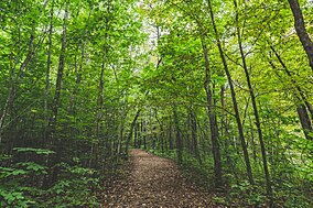
Big Woods refers to a type of temperate hardwood forest ecoregion found in western Wisconsin and south-central Minnesota. "Big Woods" is a direct translation of the name given to the region by French explorers: Grand Bois.

Cedars of Lebanon State Park is a state park in Wilson County, Tennessee, in the southeastern United States. It consists of 900 acres (364 ha) situated amidst the 9,420-acre (3,810 ha) Cedars of Lebanon State Forest. The park and forest are approximately 10 miles (16 km) south of Lebanon, Tennessee.

Mary Jane Thurston State Park is a 591-acre (239 ha) Ohio state park in Wood and Henry Counties, Ohio in the United States. It is named for Mary Jane Thurston, a schoolteacher from Grand Rapids, Ohio who bequeathed 14 acres (57,000 m2) of land for the establishment of a park. The park is along the Maumee River near the remains of the historic Miami and Erie Canal. Mary Jane Thurston State Park is open for year-round recreation including, hunting, fishing and boating, picnicking, camping and hiking.

Knob Noster State Park is a public recreation area covering 3,934 acres (1,592 ha) in Johnson County, Missouri, in the United States. The state park bears the name of the nearby town of Knob Noster, which itself is named for one of two small hills or "knobs" that rise up in an otherwise flat section of Missouri. Noster is a Latin adjective meaning "our"—therefore, Knob Noster translates as "our hill." A local Indian belief stated that the hills were "raised up as monuments to slain warriors." The park offers year-round camping, hiking, and fishing and is managed by the Missouri Department of Natural Resources.

The Birch Lakes State Forest is a state forest located in Stearns County, Minnesota. One of the smallest Minnesota state forests, it is managed primarily for recreation by the Minnesota Department of Natural Resources. Big Birch Lake, a 2,112 acres (855 ha) sand- and marl-bottomed lake, is accessible from the northeast corner of the forest. The forest is located in a transitory ecotone between the temperate deciduous forest to the northeast and the tallgrass prairie to the southwest, with the rolling terrain characteristic of the glacial activity in the area.

Greenleaf Lake State Recreation Area is a state park unit of Minnesota, USA, currently in development. It includes undeveloped shoreline on both Greenleaf and Sioux Lakes, halfway between the cities of Hutchinson and Litchfield in Meeker County. Portions of the state recreation area (SRA) are open to the public for day-use recreation, but there are no facilities yet on site. The park boundaries were set by the Minnesota Legislature and the state is still acquiring land from willing sellers; two-thirds of the property remain privately owned.