Voyageurs National Park is an American national park in northern Minnesota near the city of International Falls established in 1975. The park's name commemorates the voyageurs—French-Canadian fur traders who were the first European settlers to frequently travel through the area. Notable for its outstanding water resources, the park is popular with canoeists, kayakers, other boaters, and fishermen. The Kabetogama Peninsula, which lies entirely within the park and makes up most of its land area, is accessible only by boat. To the east of the park lies the Boundary Waters Canoe Area Wilderness.
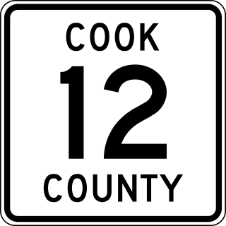
County State-Aid Highway 12 (CSAH 12), also known as the Gunflint Trail, or County Road 12 (CR 12), is a 57-mile (92 km) paved roadway and National Scenic Byway in Cook County, Minnesota, that begins in Grand Marais and ends at Saganaga Lake in the Boundary Waters Canoe Area Wilderness (BWCAW), near the U.S. border with Ontario. It provides access to many of the entry points in the BWCAW.

Savanna Portage State Park is a state park of Minnesota, USA, established in 1961 to preserve the historic Savanna Portage, a difficult 6-mile (9.7 km) trail connecting the watersheds of the Mississippi River and Lake Superior. The portage trail crosses a drainage divide separating the West Savanna River, which drains to the Mississippi River and the Gulf of Mexico, from the East Savanna River, which flows in an opposite direction to the Saint Louis River, Lake Superior and the Great Lakes, and the Saint Lawrence River to the Atlantic Ocean.

Tettegouche State Park, pronounced “tet-a-gooch”, in the United States, is a Minnesota state park on the north shore of Lake Superior 58 miles (93 km) northeast of Duluth in Lake County on scenic Minnesota Highway 61. The park's name stems from the Tettegouche Club, an association of local businessmen which purchased the park in 1910 from the Alger-Smith Lumber Company. The club's members protected the area until its sale in 1971 to the deLaittres family. In 1979, the state of Minnesota acquired 3,400 acres (1,400 ha) from the Nature Conservancy, including Tettegouche Camp. The land was added to Baptism River State Park, which was renamed Tettegouche State Park.

Wild River State Park is a state park of Minnesota, United States, curving along 18 miles (29 km) of the St. Croix River. This long, narrow park is shaped somewhat like a sideways 'S', with development largely concentrated in the lower third. The remote upper sections flank the mouth of a tributary called the Sunrise River. The park is managed to provide quieter, more nature-oriented recreation as a counterpoint to the busier William O'Brien and Interstate State Parks downstream.

Zippel Bay State Park is a state park in Lake of the Woods County, Minnesota in the United States. It is on the white sand beach shoreline of the Lake of the Woods, near the United States border with Canada. The park is open for year-round recreation including camping, hiking, fishing and cross-country skiing.
Frontenac State Park is a state park of Minnesota, United States, on the Mississippi River 10 miles (16 km) southeast of Red Wing. The park is notable both for its history and for its birdwatching opportunities. The centerpiece of the park is a 430-foot-high (130 m), 3-mile-long (4.8 km) steep limestone bluff overlooking Lake Pepin, a natural widening of the Mississippi. The bluff is variously called Garrard's Bluff or Point No-Point, the latter name coming from riverboat captains because of the optical illusion that it protruded into the Mississippi River. There is a natural limestone arch on the blufftop called In-Yan-Teopa, a Dakota name meaning "Rock With Opening". Park lands entirely surround the town of Frontenac, once a high-class resort at the end of the 19th century.

Jay Cooke State Park is a state park of Minnesota, United States, protecting the lower reaches of the Saint Louis River. The park is located about 10 miles (16 km) southwest of Duluth and is one of the ten most visited state parks in Minnesota. The western half of the park contains part of a rocky, 13-mile (21 km) gorge. This was a major barrier to Native Americans and early Europeans traveling by canoe, which they bypassed with the challenging Grand Portage of the St. Louis River. The river was a vital link connecting the Mississippi waterways to the west with the Great Lakes to the east.

St. Croix State Park is a state park in Pine County, Minnesota, USA. The park follows the shore of the St. Croix River for 21 miles (34 km) and contains the last 7 miles (11 km) of the Kettle River. At 33,895 acres (13,717 ha) it is the largest Minnesota state park. It was developed as a Recreational Demonstration Area in the 1930s, and is one of the finest surviving properties of this type in the nation. 164 structures built by the Civilian Conservation Corps and the Works Progress Administration survive, the largest collection of New Deal projects in Minnesota. As a historic district they were listed on the National Register of Historic Places and proclaimed a National Historic Landmark in 1997.

Big Bog State Recreation Area, a recent addition to the Minnesota state park system, is located on Minnesota State Highway 72, north of Waskish, Minnesota. It covers 9,459 acres (38.3 km2), primarily swamps, bogs, and upland "islands".
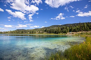
Kentucky Alleyne Provincial Park is a provincial park in British Columbia. The park is located 38 kilometres south of Merritt, British Columbia.

Lake Bemidji State Park is a state park of Minnesota, United States, on the north shore of 6,765-acre (27.38 km2) Lake Bemidji. The northern half of the park preserves a spruce-tamarack bog. A district of National Park Service rustic structures built by the Civilian Conservation Corps and National Youth Administration in the 1930s is on the National Register of Historic Places. The park is located 5 miles (8.0 km) north of the city of Bemidji.
The Willard Munger State Trail is a system of recreational trails between Hinckley, Minnesota and Duluth, Minnesota. There are three segments to the trail, Hinckley to Duluth Segment, Alex Laveau Memorial Trail, and Matthew Lourey State Trail.

Yellowstone Lake State Park is a state park of Wisconsin, United States, featuring a 455-acre (184 ha) reservoir on a tributary of the Pecatonica River. The state park is included in the 4,047-acre (1,638 ha) Yellowstone Lake State Wildlife Area. The park has 128 campsites and 5 group sites. There is a swimming area with sand beach, picnic areas, and playgrounds. Boat launch, boat rentals, fishing for bluegill, largemouth bass, walleye and channel catfish, with some northern pike and muskellunge. Hiking trails, and groomed cross country ski trails. The adjacent 4,000 acre wildlife area offers extensive horse trails and a shooting range.
Kabetogama is an unincorporated community in Kabetogama Township, Saint Louis County, Minnesota, United States, located within the Kabetogama State Forest.

Tobin Lake is a reservoir along the course of the Saskatchewan River in the Canadian province of Saskatchewan. Tobin Lake was formed by the building of the E.B. Campbell Dam on the Saskatchewan River in 1963. The dam was originally named Squaw Rapids Dam, but was renamed E.B. Campbell Dam in 1988 as the term squaw is derogatory. The town of Nipawin is near the western end of the lake and upstream from Nipawin along the Saskatchewan River is Codette Lake, which was formed by the construction of the Francois Finlay Dam in 1986. Situated between these two man-made lakes, Nipawin earned the nickname The Town of Two Lakes.
Narrow Hills Provincial Park is a northern boreal forest provincial recreational park in the Canadian province of Saskatchewan. It is located in a hilly plateau called the Cub Hills and contains several recreational facilities and over 25 accessible lakes within its boundaries. The geographical features of the park, including the lakes, valleys, and lowlands were formed over 10,000 years ago during the last ice age. The town of Smeaton is the closest community and it is located 70 kilometres (43 mi) to the south.

Willard Pond is a small, protected lake in Antrim, New Hampshire, United States. The lake, located in southwestern New Hampshire, is about 108 acres (44 ha) in size with an average depth of 25 feet (7.6 m) and a maximum depth of 58 feet (18 m). No petroleum motors are allowed, and fly fishing is the only form of fishing allowed. It is part of the dePierrefeu Wildlife Sanctuary, which is owned by the New Hampshire Audubon Society. Because the pond and the land around it are part of the sanctuary, the shore is unable to be developed. Therefore, there are no buildings around the pond and there won't be in the foreseeable future. Willard is instead surrounded by extensive amounts of wilderness and hiking trails that lead around the pond and to the summits of Bald Mountain and Goodhue Hill. Willard is a popular fishing, boating and hiking destination, and it has become more popular with its mention in numerous magazines and newspapers.
Greenwater Lake Provincial Park is a provincial park in the Canadian province of Saskatchewan. It is located on the eastern side of the province in the Porcupine Hills on Highway 38. The closest town, Porcupine Plain, is about 28 kilometres to the north-east of the park visitor centre. Founded on 19 February 1932, Greenwater is one of the oldest provincial parks in Saskatchewan. The original six parks were established in 1931 and Greenwater Provincial Park was added one year later. In 1964, the park was expanded to its current size.
Minnesota Scenic Byways are a system of roads in the U.S. state of Minnesota which pass through areas of scenic, cultural, or recreational significance. There are currently 22 scenic byways in the system with a total length of 2,948 miles (4,744 km). Eight of these byways are also designated as National Scenic Byways, and the North Shore Scenic Drive is further designated as an All-American Road.