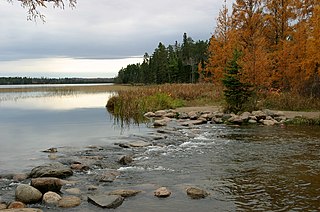
Itasca State Park is a state park of Minnesota, United States, and contains the headwaters of the Mississippi River. The park spans 32,690 acres (132.3 km2) of northern Minnesota, and is located about 21 miles (34 km) north of Park Rapids, Minnesota and 25 miles (40 km) from Bagley, Minnesota. The park is part of Minnesota's Pine Moraines and Outwash Plains Ecological Subsection and is contained within Clearwater, Hubbard, and Becker counties.

The St. Croix River is a tributary of the Mississippi River, about 169 mi (272 km) long, in the U.S. states of Wisconsin and Minnesota. The lower 125 mi (201 km) of the river form the border between Wisconsin and Minnesota. The river is a National Scenic Riverway under the protection of the National Park Service. A hydroelectric plant at the Saint Croix Falls Dam supplies power to the Minneapolis–Saint Paul metropolitan area.

Banning State Park is a state park in Pine County, Minnesota, United States, stretched along 10 miles (16 km) of the Kettle River near the town of Sandstone. The centerpiece of the park is 1.5 miles (2.4 km) of churning rapids, some up to Class IV. The daring kayakers and canoeists who shoot Blueberry Slide, Mother's Delight, Dragon's Tooth, Little Banning, and Hell's Gate each spring attract spectators to the park. Landbound visitors can hike along the state's first Wild and Scenic River amid dramatic sandstone rock formations, large potholes carved by the river, and the remains of a historic quarry. Other features are Wolf Creek Falls and Robinson Ice Cave. The park is located directly off Interstate 35. Banning State Park is open daily from 8am until 10pm. Each vehicle entering the park requires an up-to-date permit which can be purchased online or at the park office.

Wild River State Park is a state park of Minnesota, United States, curving along 18 miles (29 km) of the St. Croix River. This long, narrow park is shaped somewhat like a sideways 'S', with development largely concentrated in the lower third. The remote upper sections flank the mouth of a tributary called the Sunrise River. The park is managed to provide quieter, more nature-oriented recreation as a counterpoint to the busier William O'Brien and Interstate State Parks downstream.

Interstate Park comprises two adjacent state parks on the Minnesota–Wisconsin border, both named Interstate State Park. They straddle the Dalles of the St. Croix River, a deep basalt gorge with glacial potholes and other rock formations. The Wisconsin park is 1,330 acres (538 ha) and the Minnesota park is 298 acres (121 ha). The towns of Taylors Falls, Minnesota and St. Croix Falls, Wisconsin are adjacent to the park. Interstate Park is within the Saint Croix National Scenic Riverway and the Ice Age National Scientific Reserve. The western terminus of the Ice Age National Scenic Trail is on the Wisconsin side. On the Minnesota side, two areas contain National Park Service rustic style buildings and structures that are listed on the National Register of Historic Places.

Grand Portage State Park is a state park at the northeastern tip of the U.S. state of Minnesota, on the Canada–United States border. It contains a 120-foot (37 m) waterfall, the tallest in the state, on the Pigeon River. The High Falls and other waterfalls and rapids upstream necessitated a historically important portage on a fur trade route between the Great Lakes and inland Canada. This 8.5-mile (13.7 km) path as well as the sites of historic forts at either end are preserved in nearby Grand Portage National Monument.

William O'Brien State Park is a 1,520-acre (6.2 km2) state park of Minnesota, USA, along the St. Croix River. Its hiking trails traverse rolling glacial moraine, riparian zones, restored oak savanna, wooded areas and bogs. It is a popular place for birdwatching, picnics, camping, cross-country skiing, canoeing, fishing, and other typical outdoor recreational activities.

Judge C. R. Magney State Park is a state park in the U.S. state of Minnesota, on the North Shore of Lake Superior. It was named for Clarence R. Magney, a former mayor of Duluth and justice of the Minnesota Supreme Court, who was instrumental in getting 11 state parks and scenic waysides established along the North Shore. The park is best known for the Devil's Kettle, an unusual waterfall and rock formation in which half of the Brule River disappears into a pothole.

St. Croix State Park is a state park in Pine County, Minnesota, USA. The park follows the shore of the St. Croix River for 21 miles (34 km) and contains the last 7 miles (11 km) of the Kettle River. At 33,895 acres (13,717 ha) it is the largest Minnesota state park. It was developed as a Recreational Demonstration Area in the 1930s, and is one of the finest surviving properties of this type in the nation. 164 structures built by the Civilian Conservation Corps and the Works Progress Administration survive, the largest collection of New Deal projects in Minnesota. As a historic district they were listed on the National Register of Historic Places and proclaimed a National Historic Landmark in 1997.
The Willard Munger State Trail is a system of recreational trails between Hinckley and Duluth, Minnesota. The trail's three segments are the Hinckley to Duluth Segment, Alex Laveau Memorial Trail, and Matthew Lourey State Trail.

The Minnesota Department of Natural Resources, or Minnesota DNR, is the agency of the U.S. state of Minnesota charged with conserving and managing the state's natural resources. The agency maintains areas such as state parks, state forests, recreational trails, and recreation areas as well as managing minerals, wildlife, and forestry throughout the state. The agency is divided into six divisions - Ecological & Water Resources, Enforcement, Fish & Wildlife, Forestry, Lands & Minerals, and Parks & Trails.

The Saint Croix National Scenic Riverway is a federally protected system of riverways located in eastern Minnesota and northwestern Wisconsin. It protects 252 miles (406 km) of river, including the St. Croix River, and the Namekagon River, as well as adjacent land along the rivers. The St. Croix National Scenic Riverway is one of the original eight National Wild and Scenic Rivers, largely as a result of legislation by senators Walter Mondale of Minnesota and Gaylord Nelson of Wisconsin. The largest scenic riverway east of the Mississippi River, it lies within parts of eight counties in Wisconsin: Bayfield, Burnett, Douglas, Pierce, Polk, St. Croix, Sawyer, and Washburn; and three in Minnesota: Chisago, Pine, and Washington.

The St. Croix Boom Site is a historic and scenic wayside on the St. Croix River in Stillwater Township, Minnesota, United States. It commemorates the location of a critical log boom where, from 1856 to 1914, timber from upriver was sorted and stored before being dispatched to sawmills downstream. The site was developed as a roadside park along Minnesota State Highway 95 in the 1930s. In 1966 it was designated a National Historic Landmark for its national significance in the theme of industry. It was nominated for being the earliest, most important, and longest serving of the log storage and handling operations that supported Minnesota's major logging industry. Virtually no traces remain of the site's original buildings and structures.
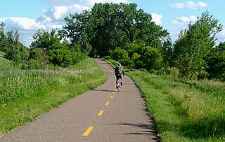
The Gateway State Trail is a multi-use recreational rail trail in the U.S. state of Minnesota, running 18 miles (29 km) from Saint Paul to Pine Point Regional Park in Stillwater. It runs through urban landscapes of eastern Saint Paul in Ramsey County and rural farmland and forests in Washington County. It was designated a National Recreation Trail in 2002.
The Fond du Lac State Forest is a state forest in Minnesota, United States, principally managed by the Minnesota Department of Natural Resources (MDNR). The main segment of the forest is located between the towns of Sawyer and Cromwell, in Carlton County. The boundaries of the forest overlap with those of the Fond du Lac Indian Reservation, some state forest land falls within the reservation. The Kettle Lake Wildlife Management Area is located in the southern half of the main segment. A smaller segment is located adjacent to Jay Cooke State Park and the border with Wisconsin in Saint Louis County.
The Crow Wing State Forest is a state forest located near Fairfield Township in Crow Wing County, Minnesota. It is about 20 miles (32 km) northeast of the tourism-based town of Brainerd. Approximately 14,072 acres (5,695 ha) (44%) of the forest of 31,307 acres (12,669 ha) is actively managed. The managed acres are split nearly equally between the Minnesota Department of Natural Resources, Crow Wing County, and the privately owned Potlatch Corp.
The Beltrami Island State Forest is a state forest located in Lake of the Woods, Roseau, and Beltrami counties, Minnesota. Named after Italian explorer Giacomo Beltrami, it is the second-largest state forest in the Minnesota system after Pine Island State Forest. The largest wildlife management area in the state at 321,149 acres (129,964 ha), the Red Lake Wildlife Management Area, is located within the forest. The majority of the forest is managed by the Minnesota Department of Natural Resources, although a significant portion are tribal lands belonging to the neighboring Red Lake Band of Ojibwe.

The Grand Portage State Forest is a state forest located near the community of Hovland in Cook County, in extreme northeastern Minnesota. The forest encloses Judge C. R. Magney State Park, Swamp River Wildlife Management Area, Hovland Woods Scientific and Natural Area, and Spring Beauty Hardwoods Scientific and Natural Area. It borders the Grand Portage Indian Reservation to the east, the Superior National Forest to the west, and Ontario to the north. The forest is named after the Grand Portage, a historic trade route between the Great Lakes and the Northwest.
The Nemadji State Forest is a state forest located primarily in Pine County, Minnesota. A small portion of the forest extends into neighboring Carlton County. The eastern perimeter of the forest borders the state of Wisconsin. It is managed by the Minnesota Department of Natural Resources. Gray wolves, white-tailed deer, and eagles are present in the forest.
Minnesota Scenic Byways are a system of roads in the U.S. state of Minnesota which pass through areas of scenic, cultural, or recreational significance. There are currently 22 scenic byways in the system with a total length of 2,948 miles (4,744 km). Eight of these byways are also designated as National Scenic Byways, and the North Shore Scenic Drive is further designated as an All-American Road.
