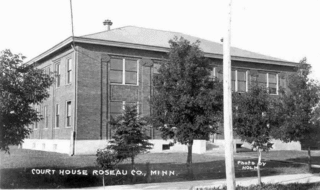
Roseau County is a county in the northwestern part of the U.S. state of Minnesota, along the Canada–US border. As of the 2020 census, the population was 15,331. Its county seat is Roseau. Roseau County borders the Canadian province of Manitoba.
Itasca State Park is a state park of Minnesota, United States, and contains the headwaters of the Mississippi River. The park spans 32,690 acres (132.3 km2) of northern Minnesota, and is located about 21 miles (34 km) north of Park Rapids, Minnesota and 25 miles (40 km) from Bagley, Minnesota. The park is part of Minnesota's Pine Moraines and Outwash Plains Ecological Subsection and is contained within Clearwater, Hubbard, and Becker counties.

Savanna Portage State Park is a state park in the U.S. State of Minnesota established in 1961 to preserve the historic Savanna Portage, a difficult 6-mile (9.7 km) trail connecting the watersheds of the Mississippi River and Lake Superior. The portage trail crosses a drainage divide separating the West Savanna River, which drains to the Mississippi River and the Gulf of Mexico, from the East Savanna River, which flows in an opposite direction to the Saint Louis River, Lake Superior and the Great Lakes, and the Saint Lawrence River to the Atlantic Ocean.

Judge C. R. Magney State Park is a state park in the U.S. state of Minnesota, on the North Shore of Lake Superior. It was named for Clarence R. Magney, a former mayor of Duluth and justice of the Minnesota Supreme Court, who was instrumental in getting 11 state parks and scenic waysides established along the North Shore. The park is best known for the Devil's Kettle, an unusual waterfall and rock formation in which half of the Brule River disappears into a pothole.

Glacial Lakes State Park is a state park of Minnesota, USA, approximately 5 miles (8.0 km) south of Starbuck. It was founded in 1963 to preserve some of the remaining rolling prairie which previously covered much of the state. Located in the Leaf Mountains, the park and the area around it contains many glacial landforms created by the Wisconsonian glaciation.
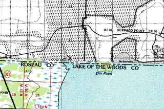
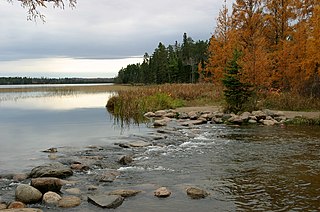
Elm Point, Minnesota, is a small uninhabited cape and a practical exclave of the United States in Lake Township, Roseau County, Minnesota, United States. It is surrounded on the west, south, and east by Lake of the Woods, and on the north by the Canadian First Nation community of Buffalo Point in southeastern Manitoba. Part of Elm Point is privately owned and part of it is state land managed by the Department of Natural Resources as part of the Border Wildlife Management Area. It is located southwest of the much larger exclave known as the Northwest Angle. There is a line of felled trees marking the international border, which runs nominally along the 49th parallel, although in this area it runs slightly to the south due to 19th-century surveying errors.

The U.S. State of Minnesota is the northernmost state outside Alaska; its isolated Northwest Angle in Lake of the Woods is the only part of the 48 contiguous states lying north of the 49th parallel north. Minnesota is in the U.S. region known as the Upper Midwest in interior North America. The state shares a Lake Superior water border with Michigan and Wisconsin on the northeast; the remainder of the eastern border is with Wisconsin. Iowa is to the south, South Dakota and North Dakota are to the west, and the Canadian provinces of Manitoba and Ontario are to the north. With 87,014 square miles (225,370 km2), or approximately 2.26% of the United States, Minnesota is the 12th largest state.
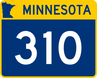
Trunk Highway 310 (MN 310) is a highway in northwest Minnesota, which runs from its intersection with MN 11 and MN 89 in Roseau and continues north to its northern terminus at the Canadian border; where the route becomes Manitoba Provincial Road 310 (PR 310) upon crossing the border, near the community of South Junction, Manitoba. The highway is 10.5 miles (16.9 km) in length.

The natural history of Minnesota covers the plant and animal species of the U.S. state of Minnesota. The continental climate and location of Minnesota at the physiographic intersection of the Laurentian and the Interior Plains influences its plant and animal life. Three of North America's biomes converge in Minnesota: prairie grasslands in the southwestern and western parts of the state, the eastern temperate deciduous forests in the east-central and the southeast, and the coniferous forest in the north-central and northeast.

Pocomoke River State Park is a public recreation area lying on both banks of the Pocomoke River between Snow Hill and Pocomoke City in Worcester County, Maryland. The state park comprises two areas within Pocomoke State Forest: Shad Landing on the south bank of the river and Milburn Landing on the north bank.

The Cloquet Valley State Forest encompasses 327,098 acres (1,323.7 km2); 48,384 acres (195.8 km2) of which are Minnesota Department of Natural Resources forestry administered lands.
Pass a Loutre Wildlife Management Area (WMA) is a 115,000-acre (47,000 ha) protected wetland in Plaquemines Parish, Louisiana, United States. The WMA is located due south and bordering the 48,000 acre Delta National Wildlife Refuge, accessible only by air or boat, contains the Pass A L'Outre Lighthouse, and Port Eads is within the boundary.
The Beltrami Island State Forest is a state forest located in Lake of the Woods, Roseau, and Beltrami counties, Minnesota. Named after Italian explorer Giacomo Beltrami, it is the second-largest state forest in the Minnesota system after Pine Island State Forest. The largest wildlife management area in the state at 321,149 acres (129,964 ha), the Red Lake Wildlife Management Area, is located within the forest. The majority of the forest is managed by the Minnesota Department of Natural Resources, although a significant portion are tribal lands belonging to the neighboring Red Lake Band of Ojibwe.
The Big Fork State Forest is a state forest located in Koochiching and Itasca counties, Minnesota. It is primarily managed by the Minnesota Department of Natural Resources. The landscape has many moraines, lakes, and wetlands. The "Lost 40" and the largest red pine in the state of Minnesota are located within the forest.
The Kabetogama State Forest is a state forest located in Koochiching and Saint Louis counties, Minnesota, United States. The forest borders the Superior National Forest and the Boundary Waters Canoe Area Wilderness to the east, the Sturgeon River State Forest to the south, the Nett Lake Indian Reservation to the west, and Voyageurs National Park to the north. The forest is managed by the Minnesota Department of Natural Resources.
The Koochiching State Forest is a state forest located near International Falls in Itasca, Koochiching, and Saint Louis counties, Minnesota. The forest borders the Pine Island State Forest to the west, the Big Fork State Forest and George Washington State Forest to the south, the Nett Lake Indian Reservation and the Kabetogama State Forest to the east. A leg of the forest touches Rainy Lake to the north, which forms part of the international border with Ontario. Of the 565,500 acres (2,288 km2), 344,300 acres (1,393 km2) are managed by the Minnesota Department of Natural Resources, making it one of the largest forests in the Minnesota state system.
The Lake of the Woods State Forest is a state forest located south of Lake of the Woods in Beltrami, Koochiching, Lake of the Woods and Roseau counties in Minnesota, USA. The forest borders the Pine Island State Forest to the east and the Beltrami Island State Forest to the west.
The Land o' Lakes State Forest is a state forest located primarily in Cass County, Minnesota, with portions extending into adjacent Aitkin and Crow Wing counties. The forest has small shared borders with the Chippewa National Forest to the north, and the Hill River State Forest to east. Over half of the forest's land is managed by the Minnesota Department of Natural Resources; the remaining land is managed by Cass County or is privately held.
The Mississippi Headwaters State Forest is a state forest located near the town of Wilton in Beltrami County, Minnesota. Portions of the forest extend into the neighboring counties of Clearwater and Hubbard. The majority of the forest is managed by the respective counties, with the Minnesota Department of Natural Resources managing around 9,000 acres (3,600 ha). The forest is named after its location immediately downstream (north) of Lake Itasca, the headwaters of the Mississippi River.

Greenleaf Lake State Recreation Area is a state park unit of Minnesota, USA, currently in development. It includes undeveloped shoreline on both Greenleaf and Sioux Lakes, halfway between the cities of Hutchinson and Litchfield in Meeker County. Portions of the state recreation area (SRA) are open to the public for day-use recreation, but there are no facilities yet on site. The park boundaries were set by the Minnesota Legislature and the state is still acquiring land from willing sellers; two-thirds of the property remain privately owned.
